Showing 543 items
matching rail line
-
 Orbost & District Historical Society
black and white photograph, late 19th century - early 20th century
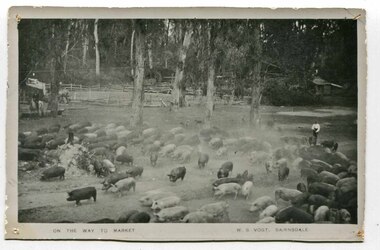
... . This method of transport continued until the rail line to Orbost... . This method of transport continued until the rail line to Orbost ...Pigs were taken to Bairnsdale by coaxing them with maize thrown from a wagonette . From Bairnsdale they were freighted to market by train. The journey to Bairnsdale took about five days . This method of transport continued until the rail line to Orbost was opened in 1916. This photograph is a pictorial record of Orbost farming practices in the early 20th century.A black / white photograph of pigs being taken to market. There are men on horseback with them.on front - On the Way to Market W.S. Vogt Bairnsdaleagriculture farming-orbost pigs -
 Port of Echuca
Black and white photograph
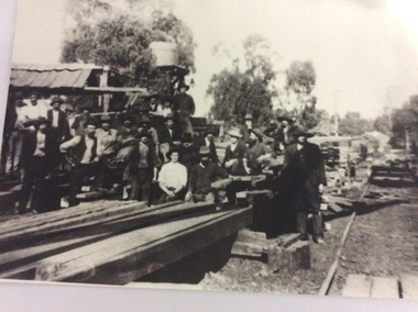
... . A tramway ran out to it from the main rail line near the iron bridge... ran out to it from the main rail line near the iron bridge ...Macintosh's sawmill was on the banks of the Murray River in Echuca east where the Banyule State forest is now located. A tramway ran out to it from the main rail line near the iron bridge. Macintoshes Sawmill was one of the largest in the area. (Ref. Clare Jackson. )Macintoshes sawmill was set up by James Macintosh in 1868 in Echuca East. His sawmill prospered and in 1878 was "equal to five normal sawmills" (Ref; Coulson, Helen, "Echuca Moama On the Murray." P.158) He also owned 2 paddle steamers and 8 barges. The Macintosh Family contributed substantially to the development of Echuca East, but by 1901 the Family was in severe debt and were forced to sell the sawmill to the Nicholas Family.A black and white photograph of a large group of men outside a sawmill, reputed to be Macintoshes Sawmill in Echuca East.On the back of the photograph written in pencil are the words "Believed to be workmen at McIntosh's mill (Charlie Dowell says)macintosh's sawmill, sawmill industry, echuca east, banyule state forest, macintosh james, dowell, charlie, logging industry, jackson, clare -
 Melbourne Tram Museum
Ephemera - Set of 5 sample - tram - rail quarterly tickets, Victorian Railways (VR), 1946
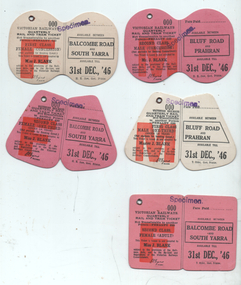
... on the Sandringham - Black Rock and rail line. All dated with an expiry date... on the Sandringham - Black Rock and rail line. All dated with an expiry date ...Set of 5 quarterly demonstration Victorian Railways tram - rail tickets for various uses and destinations on the Sandringham - Black Rock and rail line. All dated with an expiry date of 31 Dec. 1946. Not used as such, or does the reference does not show them being used.Demonstrates a set of tickets that were likely produced for discussion purposes for the Sandringham to Black Rock tram line.Set of 5 printed cloth faced tickets each with a metal eyelet and creased in the centre. All stamped "Specimen"tickets, vr, vr trams, victorian railways, sandringham to black rock -
 Melbourne Tram Museum
Photograph - Tram 780 corner Holden and Pilkington St Fitzroy North, Warren Doubleday, 23/8/1969
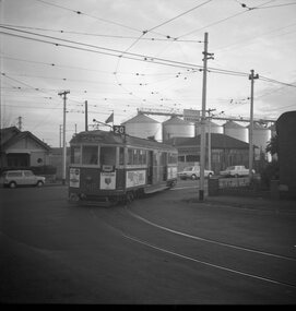
... the grain silos on the form inner circle rail line in the background. ... on the form inner circle rail line in the background. Yields ...Photo shows W5 780 turning from Holden St into Pilkington St Fitzroy North. Tram showing Special, has a "Coburg" Auxiliary board on the front and a Preston Run number. Has the grain silos on the form inner circle rail line in the background. Yields information the use of Holden St North Fitzroy.Black and White photograph of Tram 780 at the corner Holden and Pilkington St Fitzroy North.Has details on rear in blue ink.tramways, trams, tours, tram 780, holden st, pilkington st, w5 class -
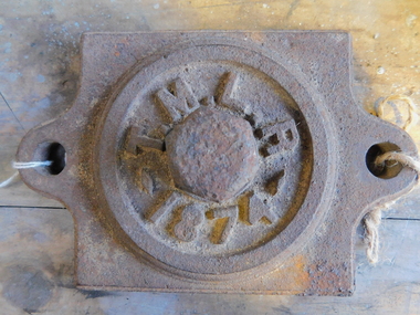 Puffing Billy Railway
Axle Box Cover - Tasmanian Main Line Co, 1874
... Axle box cover from a Tasmanian Main Line Railway rail...Axle box cover from a Tasmanian Main Line rail vehicle from... Main Line Railway rail vehicle from 1874 The Tasmanian Main ...Axle box cover from a Tasmanian Main Line Railway rail vehicle from 1874 The Tasmanian Main Line Railway Company (T.M.R.L.) was a privately owned railway company that existed in Tasmania from 1872 to 1890. The company were the first operators of rail services between Hobart and Launceston, where it connected with the Launceston and Western Railway (L.W.R.) It started construction of a 3' 6" gauge line between Hobart and Launceston in 1873 which was completed in December 1875. and was officially opened on 1 November 1876. The route of the railway was selected largely as a result of vocal local interests and accordingly traversed some reasonably unfavorable topography, particularly in the southern section. Because the TMLR had limited finances, the line was built to the narrow (1067 mm) gauge and included long sections of steep gradients and sharp curves. The final eighteen kilometres of the route from Western Junction to Launceston used the existing broad gauge alignment of the Launceston and Western Railway, with a third rail being laid for use by the narrow gauge trains A close but uncomfortable relationship with the Government was resolved in 1890 with the purchase of the company's assets by the Crown and their incorporation into the Tasmanian Government Railways on 1 October 1890. Historic early Tasmanian Main Line Railway - Vehicle Axel Box cover Axle box cover from a Tasmanian Main Line rail vehicle from 1874.T.M.L.R - 1874 -axle, tasmanian main line railway, axle box, tasmania, main line, -
 Stawell Historical Society Inc
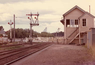
Photograph, Railway Signal Box No.1 and Signal No 2 Railway Gates -- 2 Coloured photos
... . Second photo has Napier & Victoria St in background. Note rail... in background. Note rail line is closer to signal box in 153.5 b, second ...Colour photo of No1 Signal Box and Railway Gates Seaby Street also called Signal box a. 153.5b is No 2 Signal Box. c 1974Two coloured photographs, 153.3 no.1 Signal box and railway gates. Second photo 153.5b is a front view of no. 2 Signal box. Second photo has Napier & Victoria St in background. Note rail line is closer to signal box in 153.5 b, second photo and stairs are different. Vac 74 no1 Signal box and signal gates (153.5) Vac No 2 Signal box (153.5 b)stawell -
 Sunbury Family History and Heritage Society Inc.
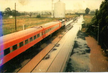
Photograph, 17 December 1985
... in Sunbury, which flooded the main Melbourne Bendigo rail line... the main Melbourne Bendigo rail line and disrupted traffic ...On 17th December 1985 record torrential rain fell in Sunbury, which flooded the main Melbourne Bendigo rail line and disrupted traffic. The photograph is looking to the north of the station and takes in the historic Macedon Street bridge and the open ground with the storage silo on the west side of the railway line. A coloured photograph of a former V Line train stopped at a station where the railway line has been flooded. A storage silo occupies vac ant ground adjacent to the railway line.sunbury railway station, storage silos, horne street -
 Kiewa Valley Historical Society
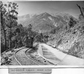
Photo - Bogong Creek Race Line
... that they built to create hydro electric power. The rail line was used... that they built to create hydro electric power. The rail line was used ...The SECV constructed the Kiewa Hydro Electric Scheme which included race lines to catch the water and feed it into the dams that they built to create hydro electric power. The rail line was used to construct the race line and enables the race line to be easily checked for maintenance eg. fallen trees The SECV constructed the Kiewa Hydro Electric Scheme from the late 1940s to 1961 being one of the first hydro schemes and hence environmently friendly.Shiny black and white photo showing the railway track, with a locomotive on it, beside the race line. Snow is on the surrounding mountains. ;Bogong Creek Race Line in pen and attafhed to the photo. On the back "Property of / State Electricity Commission of Victoria/ Publicity photo / Permission to Publish must be obtained / and acknowledgement made. / Negative No. 14-138bogong creek race line, kiewa hydro electric scheme -
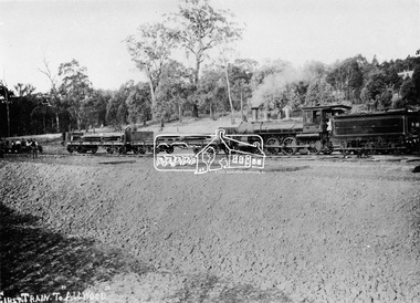 Eltham District Historical Society Inc
Photograph, First train to Hurstbridge
... which carried equipment for the construction of the rail line... which carried equipment for the construction of the rail line ...The first steam train to Hurstbridge was probably this one which carried equipment for the construction of the rail line and railway station. The formal opening of the train extension from Eltham to Hurstbridge railway station took place on June 25, 1912. The area was known as Allwood and was offically proclaimed as Hurstbridge in 1924. This photo forms part of a collection of photographs gathered by the Shire of Eltham for their centenary project book, "Pioneers and Painters: 100 years of the Shire of Eltham" by Alan Marshall (1971). The collection of over 500 images is held in partnership between Eltham District Historical Society and Yarra Plenty Regional Library (Eltham Library) and is now formally known as 'The Shire of Eltham Pioneers Photograph Collection.' It is significant in being the first community sourced collection representing the places and people of the Shire's first one hundred years.Digital imagesepp, shire of eltham pioneers photograph collection, diamond creek, hurstbridge, wattle glen, allwood, steam train, construction, railroad -
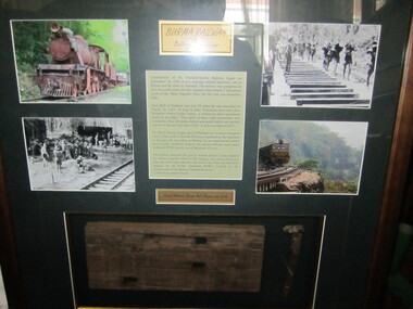 Ballarat RSL Sub-Branch Inc.
Photograph board - Framed Burma Railway, "Ballarat Connection"
... x piece of sleeper and rail line spike.Brief history of Alex... cutting. 1 x piece of sleeper and rail line spike.Brief history ...4 x photos two of WW2 era forced labours, two photos 1 of old rail engine and 1 of current train on old rail cutting. 1 x piece of sleeper and rail line spike.Brief history of Alex Bell of Ballarat. Donation plague from Selkirk Group of Comsecond world war (ww2), 1939 - 1945, photo/pictures, ballarat rsl, ballarat -
 City of Kingston
Photograph - Black and white, 20 December 1945
... and the rail line. This is now the area occupied by the extension... of land runs between the Nepean Highway and the rail line ...This aerial image covers a section of Cheltenham, with a large paddock yet to be converted to an industrial and later a commercial zone.This aerial photograph provides evidence of the changing landscape of Cheltenham and Highett since WWII. Photographed in 1945, the image features a large block of land now the site of site the major transformation of Cheltenham with the development of the Southland shopping centre in the 1960s and expansion in the 1990s.Aerial photograph of the Cheltenham area in the City of Kingston. This 1945 image is concentrated on the area between Bay Road and Garfield Lane with the distinctive bend into Jean Street. A large block of land runs between the Nepean Highway and the rail line. This is now the area occupied by the extension of Southland in the 1990s. It is a negative version of VKHC124.cheltenham, southland, market garden -
 Wycheproof & District Historical Society Inc.
Railway Book, Wycheproof Railway, 2004
... as feeder to the rail line. The Railway Station closed in December... 23 parishes would act as feeder to the rail line. The Railway ...Friday, September 28, 1883 was a memorable date for Wycheproof as on that day was the long-awaited official opening of the railway. It was recorded that no less than 23 parishes would act as feeder to the rail line. The Railway Station closed in December 1990 but the building was renovated in 2010 with plans for a community focus and cultural events.The arrival of rail opened up the Mallee. Local farmers began sending wheat, sheep and wool by rail. Improvements to transport stock was ongoing and the eventual rail extension north of the town, resulted in a well patronised passenger service for years. Railway families and workers added to the culture of the town.Display Book of A3 size with 20 pockets of Wycheproof Rail information. It includes a collection of newspaper and magazine articles, photos, rail drawings, train calendar, paint colour legend and other rail references.sea lake, railway, rail-drawing, last-passenger- train, centenary- train, train - calendar, steaming- up- broadway, wycheproof - rail -
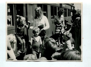 Orbost & District Historical Society
black and white photograph, second half 20th century
... Rail Line was closed as a passenger line from 1935 to be used... Rail Line was closed as a passenger line from 1935 to be used ...This photograph is of a group of pre-schoolers returning from a train trip to Nowa Nowa. It has been taken at Orbost Railway Station. A steam train? Although the Orbost Bairnsdale Rail Line was closed as a passenger line from 1935 to be used as a freight line, there were often special passenger trains.A black / white photograph of a group of women and young children alighting from a train.railway-orbost excursion-children -
 Melbourne Tram Museum
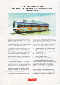
Pamphlet, Goninan & Co, "Light Rail Vehicles for the Kowloon Canton Railway Corporation (Hong Kong)", c1997
... of the 20 vehicles built for the KCRC Tuen Mun Light Rail line... for the KCRC Tuen Mun Light Rail line in Hong Kong. Published ...Pamphlet - A4, full colour two sided titled "Light Rail Vehicles for the Kowloon Canton Railway Corporation (Hong Kong)", giving details including dimensions and a side elevation of the 20 vehicles built for the KCRC Tuen Mun Light Rail line in Hong Kong. Published by Goninan, built in Newcastle, Hamiltontrams, tramways, hong kong, new trams, goninan & co., specification -
 Melbourne Tram Museum
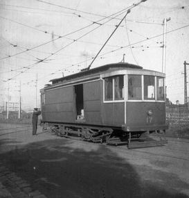
Negative, Wal Jack collection, Aug. 1940
... No. 17 in Cameron St, Brunswick. Has the Coburg rail line... No. 17 in Cameron St, Brunswick. Has the Coburg rail line ...Black and white negative, by Wal Jack, of Freight car No. 17 in Cameron St, Brunswick. Has the Coburg rail line in the background. Shows the 21E truck. Dated 8/1940. May not be a Wal Jack photograph as odd negative size. See also Reg item 5333 for another photo of this car at Brunswick.trams, tramways, freight tram, brunswick, cameron st, brill 21e, tram 17 -
 Melbourne Tram Museum
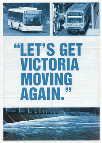
Pamphlet, Liberal Party, "Let's get Victoria Moving Again", 2010
... for rail line to Rowville. Quotes Ted Baillieu - used for the 2010..., free travel for students and feasibility study for rail line ...Pamphlet - A4 printed on white gloss paper titled "Let's get Victoria Moving Again" - promoting the transport plan for the Liberal Party - abolishing zone 3, incorporation of the Met to Mornington Peninsular, free travel for students and feasibility study for rail line to Rowville. Quotes Ted Baillieu - used for the 2010 election.trams, tramways, liberal party, tickets, fares, the met -
 Ballarat Tramway Museum
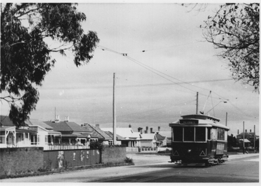
Photograph - Tram 32 Victoria St, late 1950s
... rail line shortly before the Victoria St terminus. The tram has... rail line shortly before the Victoria St terminus. The tram has ...The photograph shows SEC Ballarat trams Nos. 32 crossing over the road over the rail bridge for the former Buninyong rail line shortly before the Victoria St terminus. The tram has been fitted with reflective triangles on the front dash dated the photo between 1956 and 1960. Photographer unknown.Yields information about tram 32 and the Victoria St rail bridge.Black and White print on plain paper.tramcars, tram 32, victoria st, bridge -
Port Melbourne Historical & Preservation Society
Photograph - Woolsheds between Beacon and Barak Roads, Port Melbourne, Don Hossack, 1947
... sheds and rail line. The wool sheds were built by the Americans... sheds and rail line. The wool sheds were built by the Americans ...Donated by Don Hossack who took the photograph when he was 16 years old and working at the woolsheds. He recalls that bags of oats and barley were stored here.Photo (10 x 12" glossy black and white print) of the wool sheds between Beacon and Barak Roads. Shows north easternmost sheds and rail line. The wool sheds were built by the Americans during World War II and taken down again in the 1950s . Map (hand drawn) on rear shows location of photograph.map (hand drawn) of location of photographtransport - railways, built environment - industrial, war - world war ii -
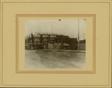 Kew Historical Society Inc
Photograph - Railway level crossing in Glenferrie Road, Glenferrie, E.J. Dower, 1912-13
... of the train level crossing and the elevation of the rail line above... level crossing and the elevation of the rail line above the road ...One of a series of photographs, taken by Edgar James Dower in the second decade of the twentieth century. Born and raised in Olinda, his family later moved to Surrey Hills. He worked as an adult as a clerk in the city office of the Metropolitan Gas Company, and in his role as a 'collector', he was able to photograph scenes including the construction of tramlines and associated buildings in Kew, Hawthorn, Camberwell and Surrey Hills. Later he established a real estate agency with his brother - the E.J. Dower Real Estate Agency, Dandenong Office.The image is an historically significant record of the development of transport infrastructure which was used to connect Victorians in the first two decades of the twentieth century. This development resulted from increases in population and the consequent extension of Melbourne's suburbs. The photographs, both individually and collectively, richly detail the labour of workers and the tools and machinery used to create and extend Melbourne's public transport network in the years preceding and during World War 1.Digital copy of an original mounted photograph showing the old railway crossing in Glenferrie Road, Hawthorn. The removal of the train level crossing and the elevation of the rail line above the road was designed to enable the laying of tram tracks along Glenferrie Road. The buildings to the right of the photo were being demolished to allow for this. "The Don Store" is immediately behind the crossing.Annotated verso: "1912 / Demolishing shops near Glenferrie Railway Station, just prior to the regrading of line to camberwell / Taken by E.J. Dower 1912"theme --- travelling by tram, theme -- connecting victorians by transport and communications, glenferrie railway station, glenferrie road -- hawthorn (vic.), railways -- hawthorn -
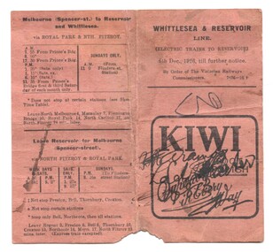 Melbourne Tram Museum
Ephemera - Timetable, Victorian Railways, "Whittlesea & Reservoir Line", Dec. 1926
... on the Reservoir (Whittlesea, currently Mernda) rail line. Shows... on the Reservoir (Whittlesea, currently Mernda) rail line. Shows the trains ...Timetable - folded brown card titled "Whittlesea & Reservoir Line" dated 6/12/1926 detailing train services on the Reservoir (Whittlesea, currently Mernda) rail line. Shows the trains that ran via Royal Park, or Clifton Hill. The Royal Park services were in effective competition with the tramways. Has an advert for Kiwi Boot Polish.trams, tramways, timetables, vr, reservoir, clifton hill, royal park, inner circle -
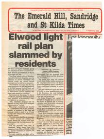 Melbourne Tram Museum
Newspaper, The Emerald Hill, Sandridge and St Kilda Times, "Elwood light rail plan slammed by residents", 8/09/1988 12:00:00 AM
... Kilda Light rail line into Elwood; the residents using... Trams tramways St Kilda Elwood Light Rail New Tramway Newspaper ...Newspaper clipping from "The Emerald Hill, Sandridge and St Kilda Times", titled "Elwood light rail plan slammed by residents", 8 September 1988, about the proposed extension of the St Kilda Light rail line into Elwood; the residents using such terms as appalled, ridiculous, futile, traffic problems, though the City of St Kilda was supportive.trams, tramways, st kilda, elwood, light rail, new tramway -
 Greensborough Historical Society
Map, Melbourne and Metropolitan Board of Works. Survey Division, MMBW, Yarra 2500 / 13.28. Mernda, Wilton Vale, 1977_08
... Lines. The abandoned rail line (old Whittlesea line... and SEC Transmission Lines. The abandoned rail line (old ...Melbourne and Metropolitan Board of Works. Yarra 2500 [base map] 13.28. Mernda, Wilton Vale. Municipality of Diamond Valley 257 and Whittlesea 239. Prominent streets: Wilton Vale Road. Features include Yan Yean Pipe Track and SEC Transmission Lines. The abandoned rail line (old Whittlesea line) is in the top left corner.MMBW Map in 1:2500 [scale] series. Cream parchment with green tape reinforcing on edges and punched holes on left edge.mmbw, melbourne and metropolitan board of works, shire of diamond valley, mernda - maps -
 Greensborough Historical Society
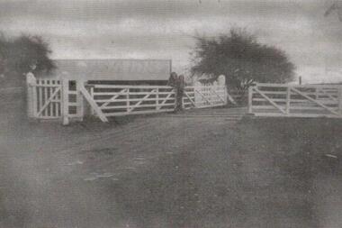
Photograph, Railway Gates at Grimshaw Street Greensborough, 1930c
... to the double rail line and building in background. Please contact... that this is the case due to the double rail line and building in background ...Two women are standing at the railway crossing gates, ready to open or close the gates [Possibly Iredale family?]. Originally thought to be the rail crossing at Grimshaw Street and Old Greensborough Road. In 2023, there is doubt that this is the case due to the double rail line and building in background. Please contact the Society if you have any idea where this is located.Copy of photo of railway gates. Sepia.On back: "Godwill from Val Wilson"railway gates, rail crossing, iredale -
 Greensborough Historical Society
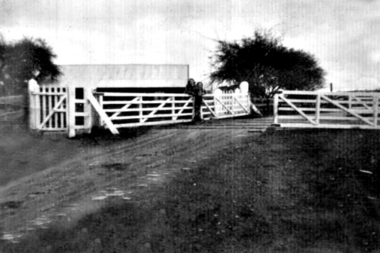
Photograph - Digital Image, Grimshaw Street rail crossing, 1930c
... to the double rail line and building in background. Please contact... that this is the case due to the double rail line and building in background ...Two women are standing at the railway crossing gates, ready to open or close the gates [Possibly Iredale family?]. Originally thought to be the rail crossing at Grimshaw Street and Old Greensborough Road. In 2023, there is doubt that this is the case due to the double rail line and building in background. Please contact the Society if you have any idea where this is located.Digital copy of black and white photograph.railway gates, iredale -
 Greensborough Historical Society
Photograph - Digital Image, Grimshaw Street Railway Gates and Crossing Greensborough, 1930c
... to the double rail line and building in background. Please contact... that this is the case due to the double rail line and building in background ...Two women are standing at the railway crossing gates, ready to open or close the gates [Possibly Iredale family?]. Originally thought to be the rail crossing at Grimshaw Street and Old Greensborough Road. In 2023, there is doubt that this is the case due to the double rail line and building in background. Please contact the Society if you have any idea where this is located.Digital copy of black and white photograph.rail crossing, iredale -
 Ballarat Tramway Museum
Photograph - Black & White Photograph/s, Leon Marshall Wood, 29/12/1947 12:00:00 AM
... and rail line in the background and part of the tram stop shelter. .... Has the level crossing and rail line in the background ...Black and White print contained within the Wal Jack Bendigo and Geelong Album, see Reg Item 5003 for more details. Photo of Bendigo Birney No.30 at North Bendigo, Photo Leon Marshall Wood, with the destination of Golden Square - 29-12-1947. Has the level crossing and rail line in the background and part of the tram stop shelter. On the rear in black ink "SEC of Victoria Bendigo, ex Geelong "Birney" car No. 30 Nth Bendigo terminus. In the bottom left hand corner "29.12.1947" The Leon Marshall Wood stamp in green ink and the number "SEC 15" written in.trams, tramways, bendigo, north bendigo, level crossings, birney, tram 30 -
 Melbourne Tram Museum
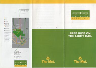
Pamphlet, The Met, "Free ride on the Light Rail", 1988
... the conversion of the Upfield rail line to light rail.... the conversion of the Upfield rail line to light rail. "Free ride ...Pamphlet - three fold DL full colour titled "Free ride on the Light Rail", providing a voucher for travel on the Upfield or North Coburg lines, to travel on the St Kilda Port Melbourne Light rail lines by circling a date on the image of a scratch ticket. Gives the conditions of travel. Used to promote the conversion of the Upfield rail line to light rail.trams, tramways, upfield, light rail, tickets, conversion, st kilda, north coburg -
 Greensborough Historical Society
Photograph - Digital Image, Gilding wedding, 1896_
... of the rail line. John married Harriet Flower Edmonds in 1896... of Main Street, north of the rail line. John married Harriet ...Informal photograph of wedding party from the Gilding family. The Gilding family lived in Greensborough and operated a Bootmaker’s shop located on the west side of Main Street, north of the rail line. John married Harriet Flower Edmonds in 1896. Standing next to the bride is Bruce Heddle and his mother Mrs W Heddle. John relocated to Diamond Creek after this wedding.Digital copy of black and white photograph. -
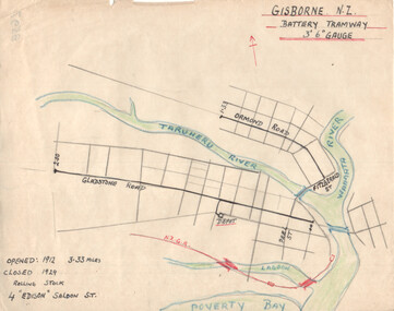 Ballarat Tramway Museum
Drawing - Gisborne NZ - Battery Tramway - plan, Wal Jack, c1946
... in Gisborne NZ. Shows the NZ rail line, rivers and the length... (four) tramcar system in Gisborne NZ. Shows the NZ rail line ...Wal Jack had an extensive range of correspondents throughout Australia and the world who often provided him with detailed drawings and notes on various tramway systems. This drawing shows the small battery-powered (four) tramcar system in Gisborne NZ. Shows the NZ rail line, rivers and the length of each route, and the dates of operation. Based on the handwriting, prepared by Wal Jack himself. Yields information about Wal Jack's extensive recording and research work.Drawing - black, red and blue ink or colour pencil on quarto size paper of the Gisborne NZ tramway system.tramways, wal jack, drawings, maps, tramcars, gisborne nz -
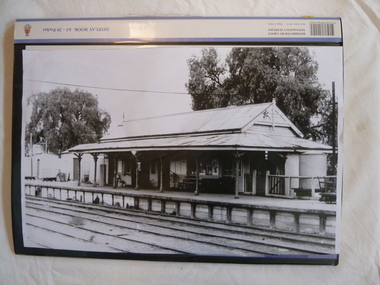
 Federation University Historical Collection
Plan, Copy of a Plan of Serviceton Railway Station Building, 1888
... the cost. Ut was at Serviceton the the Victorian rail line... was at Serviceton the the Victorian rail line and the Adelaide-Wolseley ...The Serviceton Railway Station was completed in 1889 , with the Colony of Victoria and the Colony of South Australia sharing the cost. Ut was at Serviceton the the Victorian rail line and the Adelaide-Wolseley railway line of South Australia joined. The Railway Station included customs offices which were no longer necessary after the Federation of Australian States in 1901. ( https://en.wikipedia.org/wiki/Serviceton,_Victoria, accessed 30 August 2021)Copy of plan for the Serviceton Railway Linerailway, servicetone railway station, plan, serviceton