Showing 242 items
matching residental development
-
 Whitehorse Historical Society Inc.
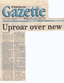
Article, Uproar over new units, 29/10/1997 12:00:00 AM
Mitcham residents and the Nunawading and District Historical SocietyMitcham residents and the Nunawading and District Historical Society have joined the growing list of objectors to a proposed 16 unit development at the corner of Mitcham Road and Meerut Street on the site of one of the few remaining historical homes in the area. The house was built in 1934 by Stanley and Helen Walker. Mr Walker's family was owner and operator of the Australian Tessellated Tile Company, an important industry for Mitcham and Victoria. The house was recognised in the 1994 City of Nunawading Heritage Survey Project and was classified as being of high local significance,Mitcham residents and the Nunawading and District Historical Societymitcham road, mitcham, meerut street, walker, stanley, helen, arrowsmith, valda, daly, peter, seamer -
 Whitehorse Historical Society Inc.
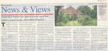
Article, Walker Estate, 22/11/1997 12:00:00 AM
Luther College Year 10 History assignment Residents in Mitcham are fighting to save one of their suburb's historic homes.Residents in Mitcham are fighting to save one of their suburb's historic homes. More than 60 objections have been received by the City of Whitehorse Planning Office to an application by Metrospan Developments to build 16 double storey units at 456 - 460 Mitcham Road, Mitcham. The proposed development is on part of the historic Walker Estate.Luther College Year 10 History assignment Residents in Mitcham are fighting to save one of their suburb's historic homes. walker estate, hogg, tony, australian tesselated tile co. pty ltd, allan, peter, buckingham, helen, rigo, anthony, metrospan developments -
 Whitehorse Historical Society Inc.
Article, Set To Sell, 1/04/1992 12:00:00 AM
Residents surrounding the former site of the Warrawong Primary SchoolResidents surrounding the former site of the Warrawong Primary School have accepted the maximum 12% public open space with 15 dwellings per hectare development.Residents surrounding the former site of the Warrawong Primary Schoolvictoria. ministry of planning & housing, warrawong primary school, city of nunawading -
Whitehorse Historical Society Inc.
Article, Hostel welcomes first residents
After five years of planning and development the Nunawading Community Hostel has taken in its first residents.After five years of planning and development the Nunawading Community Hostel has taken in its first residents. With photo.After five years of planning and development the Nunawading Community Hostel has taken in its first residents.retirement homes and villages, nunawading community hostel, wroe, chris, martin, jan, cavill, margaret, williams, pat, livingstone road, vermont south, no 39 -
Whitehorse Historical Society Inc.
Article, Blackburn beef-up?, 2009
... planning development. Blackburn residents fear a new Whitehorse ...Blackburn residents fear a new Whitehorse planning development.Blackburn residents fear a new Whitehorse planning development. David Muscat launched a group called Mega WARFARE to oppose dense developments (photo)Blackburn residents fear a new Whitehorse planning development. blackburn village residents group, muscat, david, reid, julie, morrison, david, megamile, nunawading, mega warfare -
Whitehorse Historical Society Inc.
Document, Valda Arrowsmith, 2009
Notes of an interview with Valda Arrowsmith OAM by Lesley Alves on 29 April 2009 on the opposition to the Mitcham Towers development in Colombo Street Mitcham.Notes of an interview with Valda Arrowsmith OAM by Lesley Alves on 29 April 2009 on the opposition to the Mitcham Towers development in Colombo Street Mitcham.Notes of an interview with Valda Arrowsmith OAM by Lesley Alves on 29 April 2009 on the opposition to the Mitcham Towers development in Colombo Street Mitcham.high-rise buildings, colombo street, mitcham, mitcham residents group -
Whitehorse Historical Society Inc.
Article, Call to end tower power, 2004
Opponents of the Mitcham towers are unhappy that the Whitehorse Council failed to make a decision on the development of the Mitcham buildings incl. photosOpponents of the Mitcham towers are unhappy that the Whitehorse Council failed to make a decision on the development of the Mitcham buildings incl. photosOpponents of the Mitcham towers are unhappy that the Whitehorse Council failed to make a decision on the development of the Mitcham buildings incl. photoscity of whitehorse, building permits, mitcham residents' group, hogg, tony, arrowsmith, valda, bilston, john, treacy, peter, colombo street, mitcham, high-rise buildings -
Whitehorse Historical Society Inc.
Article, Residents to fight church's $70 M plan, 2013
Seventh Day Adventist Church development of property opposite the Blackburn Lake SanctuarySeventh Day Adventist Church development of property opposite the Blackburn Lake Sanctuary encompassing a 151 dwelling retirement village, auditorium, shop and cafe, with 300 car spaces.Seventh Day Adventist Church development of property opposite the Blackburn Lake Sanctuaryseventh day adventist church, blackburn lake sanctuary, retirement homes and villages -
Whitehorse Historical Society Inc.
Article, Resident group calls for open spaces, 2013
... and renewed focus on open spaces Residential development Resident ...Whitehorse Residents and ratepayers Association.Whitehorse Residents and ratepayers Association calls for a review of proposed residential hubs and renewed focus on open spacesWhitehorse Residents and ratepayers Association.residential development, resident action, whitehorse residents and ratepayers association -
Whitehorse Historical Society Inc.
Article, Call to keep school land, 2012
... will be used for residential development. Residents in Nunawading fear ...Residents in Nunawading fear the land where the former Nunawading Primary School was situated will be used for residential development.Residents in Nunawading fear the land where the former Nunawading Primary School was situated will be used for residential development. They would prefer it to be open space.Residents in Nunawading fear the land where the former Nunawading Primary School was situated will be used for residential development.nunawading primary school no. 4190, daw, philip, whitehorse primary school, springview primary school blackburn north, whitehorse ratepayers and residents association -
Whitehorse Historical Society Inc.
Article, Deal close in Vermont land battle, 1990
Article about the negotiation between the residents and land developers over Wunderlich site developmentArticle about the negotiation between the residents and land developers over Wunderlich site development.Article about the negotiation between the residents and land developers over Wunderlich site developmentrooks road vermont, land subdivision, mitcham road vermont, wunderlich limited -
Whitehorse Historical Society Inc.
Article, Development threatens to bury famous artistic site, 2006
Residents have made a last-ditch call for the Federal Government to stop development on land where Frederick McCubbin painted his famous work 'Bush Burial' in 1890Residents have made a last-ditch call for the Federal Government to stop development on land where Frederick McCubbin painted his famous work 'Bush Burial' in 1890 (Photo of painting plus David McCubbin)Residents have made a last-ditch call for the Federal Government to stop development on land where Frederick McCubbin painted his famous work 'Bush Burial' in 1890blackburn lake sanctuary, mccubbin, frederick, mccubbin, david, wolseley crescent, blackburn, blackburn lake environmental education park committee, city of whitehorse, seventh day adventist church nunawading -
 Whitehorse Historical Society Inc.
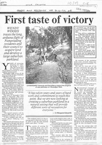
Newspaper - Article, First taste of victory, 8/04/1992
' First taste of victory' by Wendy Woods. Article in Nunawading Gazette, 8 April 1992, on background to development of Wurundjeri Walk.wurundjeri walk, parks and reserves, blackburn south residents for open space, fulton road, blackburn south, orchard grove, edwards, margaret, berry, david -
 Whitehorse Historical Society Inc.
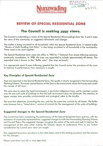
Document - Pamphlet, Review of special residential zone, 1973
City of Nunawading: review of special residential zone: seeking exemptions from residents on existing zone provisions 1973residential development, land use, city of nunawading, laburnum street, blackburn, the avenue, fuschia street, myrtle grove, linum street, acacia avenue, laurel grove, boongarry avenue, main street, gardiner street, blackburn road, jeffery street, naughton grove, special residential zone -
 Whitehorse Historical Society Inc.
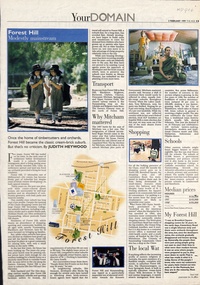
Newspaper - Article, Forest Hill: Modestly mainstream, 3/02/1999
Brief history of the development of Forest Hill and facilities available to residents.residential development, hall, noel, canterbury road, forest hill, burwood highway, vermont south, forest hill -
 Whitehorse Historical Society Inc.
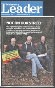
Article, Glenburnie Road Development, 2018
Members of the Glenburnie Road Residents Association, which has protected the area's unique bushland for 80 years, are protesting against the building of 11 four bedroom houses at 42-48.Members of the Glenburnie Road Residents Association, which has protected the area's unique bushland for 80 years, are protesting against the building of 11 four bedroom houses at 42-48.Members of the Glenburnie Road Residents Association, which has protected the area's unique bushland for 80 years, are protesting against the building of 11 four bedroom houses at 42-48.glenburnie road, mitcham no. 42-48, glenburnie road residents association -
 Whitehorse Historical Society Inc.
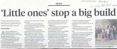
Article, Little Ones' Stop a Big Build, 2018
The State planning tribunal revoked a permit Whitehorse Council issued for an 'Overpowering' apartment block at 20 Downing Street, Blackburn.The State planning tribunal revoked a permit Whitehorse Council issued for an 'Overpowering' apartment block at 20 Downing Street, Blackburn. Local residents spent $10,000 fighting the proposed development.The State planning tribunal revoked a permit Whitehorse Council issued for an 'Overpowering' apartment block at 20 Downing Street, Blackburn. downing street, blackburn, no.20, planning development, city of whitehorse -
 Whitehorse Historical Society Inc.
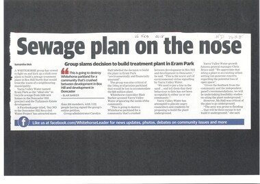
Article, Sewage Plan, 2018
... and Tullamore Estate development, but local residents are totally... Hill precinct and Tullamore Estate development, but local ...Yarra Valley Water named Eram Park as the 'ideal site' to recycle sewage from 5500 new homes in the Doncaster Hill precinct and Tullamore Estate development, but local residents are totally opposed it.sewerage and sanitation, yarra valley water, city of whitehorse, eram park -
 Whitehorse Historical Society Inc.
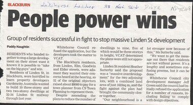
Article, Linden Street, 1/11/2016 12:00:00 AM
Residents of Linden, Elm, Goodwin and Elder Streets won a protest against a developer who took the development of 32-34 Linden Street to VCAT after it was rejected by Whitehorse Council.linden street, blackburn, city of whitehorse -
 Whitehorse Historical Society Inc.
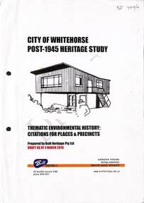
Book - Heritage Study, City Of Whitehorse Post-1945 Heritage Study, 4 March 2015
City of Whitehorse Post-1945 Heritage Study, dated 4 March 2015A4, 285 pages. A draft copy of the City of Whitehorse Post-1945 Heritage Study, dated 4 March 2015 (on front page) plus published copy of Appendix 2 pages 275-285non-fictionCity of Whitehorse Post-1945 Heritage Study, dated 4 March 2015 city of whitehorse, post war buildings, built heritage pty ltd, historic buildings, post war development, houses, architectural styles -
Ballarat Heritage Services
Document, RPD, Canadian Valley Outline Development Plan, 06/2005
According to the 2001 census the Canadian Valley was home to around 7700 residents.An overall framework for future planning and management of the Canadian Valley on the southern side of Ballarat. canadian valley, mount helen, mount clear, buninyong, ballarat technology park, federation university, university of ballarat, canadian creek, urban sprawl, koala management, urbanisation, urban growth management -
Ballarat Heritage Services
Lisa Gervasoni, Understanding Ballarat's Heritage Education Kit
A CD-ROM education package providing information on: VELS History 4 – Ballarat's heritage can tell us about key events such as Eureka, democracy, gold rushes, federation. Deakin was the member for Ballarat and was involved in the development of the Fine Art Gallery. - Ballarat’s goldfields were very multicultural in comparison to Ballarat today. Chinese made an impact on the goldfields – miners, mining techniques and in medical treatments. VELS History 5 – Eureka – what did that say about governance and justice in the 1850’s. - Working conditions and unionism .. Why would work safety and working hours be important to Ballarat. What was life like 100 years ago – what work did people do, how were domestic tasks undertaken, how was travel undertaken). culture and art – what aspects / collections tell us about life in Ballarat. (note the focus is not on medieval times but the early years of Ballarat – lessons of change and continuity still apply) VELS History – 6 – Eureka and democracy Gold rushes and development of tools and skills Trade unions and work conditions Remembrance of war Early multiculturalism Changes in technology – medical, educational, communications Technological changes made by Ballarat or Ballarat residents ballarat heritage, city of ballarat education kit -
 Department of Health and Human Services
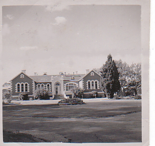
Photograph, Front of building and roundabout of Pleasant Creek Special School - Stawell - Circa 1940 to 1950
Pleasant Creek Colony history in brief Warning about distressing information Patient information Disclaimer Source On this page: Pleasant Creek Colony history in brief Warning about distressing information Patient information Disclaimer Source Pleasant Creek Colony history in brief In 1861, the Pleasant Creek Hospital opened as a medical facility for the population of Stawell and district. Another building was added in 1904, Syme Ward for convalescent patients. In 1933, the facility was replaced by a newly-built hospital in the town of Stawell. In 1934, the Mental Hygiene Department acquired the old Pleasant Creek Hospital site and converted it to accommodate children with disabilities, which became Pleasant Creek Special School. The first residents (18 boys) were admitted in 1937 from Royal Park Depot. At the end of 1937, there were 98 children living at Pleasant Creek. In 1968 the Pleasant Creek Special School was renamed Pleasant Creek Training Centre, caring for people with intellectual disabilities. From the 1950s to the 1980s, there were several building developments: •1957, Lonsdale Unit expanded capacity to 113 •1969, Bellfield and Fyans Units increased numbers to 196 •1977, Alexandra Unit converted to recreational and lecture room facility. •1977, Day Centre, Nurses' Home and Clinical Services Administration buildings •1985, Nara Unit closed for renovations and residents moved to the previous staff living quarters. https://www.findingrecords.dhhs.vic.gov.au/CollectionResultsPage/Pleasant-Creek-Colony -
 Ballarat Tramway Museum
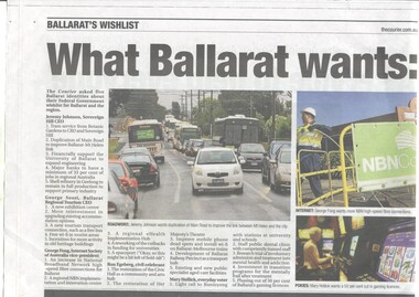
Newspaper, The Courier Ballarat, "What Ballarat wants: voters have their say", "An expensive wish list", 13/7/13 to 20/7/2013
... views of Ballarat residents about the development of Ballarat ...Yields information about views of Ballarat residents about the development of Ballarat in the future and the possible use of trams - too expensive!Set of four newspaper clippings/extracts from The Courier, about what Ballarat residents would like to see in the city and letters. Story by Tim Cowie. .1 - Newspaper clipping from The Courier, 13/7/2013 - titled "What Ballarat wants: voters have their say", under the banner "Ballarat's Wishlist" looks at local identities and their wishes. Has a suggestion for a light rail line between Ballarat and Buninyong and trams in Ballarat. .2 - Newspaper clipping from The Courier, 19/7/2013 - titled "An expensive wish list", under the heading "Trams are unlikely, but sports projects could get the nod". Quotes Ms King, Ballarat MP. .3 - Opinion section of The Courier, 20/7/2013 - "Web Words", six letters about the possibility of trams in the City of Ballarat - mainly negative. .4 - The Courier on-line version of 5916.2 ballarat, ballarat revival, tourism, new tramway -
 Queenscliffe Maritime Museum
Painting - Framed Watercolour, Fishermen's Pier Queenscliff
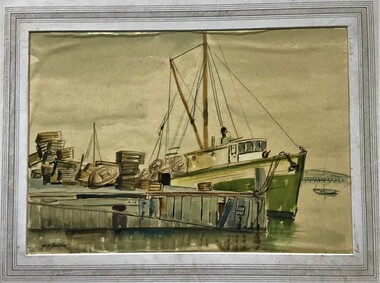
Queenscliff’s first pier, then known as the Fishermen’s Pier, was completed in 1857. It was not until some thirty years later that the second Steamer Pier was constructed adjacent to the former and periodically extended from the mid to late 1880s to cope with the demand in pleasure bay steamer services. The last of these extensions was to provide a dog-leg construction and the extant shelter shed. 1960 witnessed the demolition of the original Fishermen’s Pier - by this time having been extended in the late nineteenth and early twentieth centuries to the equivalent length of the Steamer Pier - and saw the relocation of its 1926-29 lifeboat house to the Steamer Pier, now Queenscliff Pier. The mid to late 2000s saw Queenscliff Harbour undergo large-scale redevelopment in order to deepen its waters for pleasure craft and increase its berths to over 300. This was met with strong community opposition, largely with concerns for neighbourhood character and perceived cause for gentrification its stakeholders would impart. With early construction estimates of $20 million dollars, this figure had almost doubled upon realisation. (Lovell Chen Architects. ‘Individual Property Citation’, Queenscliffe Heritage Study, 2009.) (Freya Mitchell, ‘Queenscliff residents fight a tide of development sweeping the historic town’ ABC radio, 15 April 2005).Fishermen's Pier Watercolour painting of Fishermen's Pier in Queenscliffwatercolour, fishermen's pier, queenscliff -
 Kew Historical Society Inc
Photograph, J F C Farquhar, Kew Asylum & Grounds, 1891
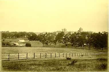
At the beginning of the 1890s, the Kew businessman and Town Councillor, Henry Kellett, commissioned J.F.C. Farquhar to photograph scenes of Kew. These scenes included panoramas as well as pastoral scenes. The resulting set of twelve photographs was assembled in an album, Kew Where We Live, from which customers could select images for purchase.The preamble to the album describes that the photographs used the ‘argentic bromide’ process, now more commonly known as the gelatine silver process. This form of dry plate photography allowed for the negatives to be kept for weeks before processing, hence its value in landscape photography. The resulting images were considered to be finely grained and everlasting. Evidence of the success of Henry Kellett’s venture can be seen today, in that some of the photographs are held in national collections.It is believed that the Kew Historical Society’s copy of the Kellett album is unique and that the photographs in the book were the first copies taken from the original plates. It is the first and most important series of images produced about Kew. The individual images have proved essential in identifying buildings and places of heritage value in the district.When the Kew Lunatic Asylum was opened in 1871, its extensive 340 acres of grounds were intended for farming, agriculture and recreation for the inmates. The point-of-view chosen by Farquhar for this panoramic photograph focuses on the ordered open fields, haystacks and remnant trees that extended from the foreground to the rear of the Asylum. The inmates are the absent players in this pastoral idyll. In 1891, The Argus reported on the Annual Asylum Picnic: “Wednesday saw the Kew picnic, the yearly festival of the mad folks and their keepers. Once a year the public subscribes for cakes and ale for all these mad folks, and their keepers, from superintendent to lowest wardsman, turn out, and use their best endeavours to make one day in the year sanely merry.” Regardless of such merriment, the Asylum’s development and ongoing status were frequently a source of disquiet to the residents of Kew, who regularly petitioned the State Government for its removal. Despite these views, the Asylum was to remain a functioning institution from 1871 to 1988. Kew Asylum & Groundskew illustrated, kew where we live, photographic books, henry kellett, kew lunatic asylum -
Kew Historical Society Inc
Journal, Kewriosity : October 1984
[Kew] Recreation Centre update [The Committee; Resident Attitude Survey] / p1. [Anglican] Archbishop's first visit to East Kew [St Paul's Church] / p1. Community [Asian Evangelical Fellowship; Hyde Park Fellowship; Kew Baptist Church; Kew Native Plant Group; Kew Garden Club; Kew (Daytime) Garden Club; Fashion Parade; The Rheumatism and Arthritis Foundation of Victoria; Retiring?; Anyone for tennis?; Games evening] / p2. Council - Mayoral Column / Cr Robin Saunders / p3. New Depot / p3. Library News / p3. Calling on people with disabilities in Kew / p3. Dieback in Kew's Plane Trees / p3. Kew's new Councillors - Roger Streeton; Chester Keon-Cohen] / p4. Kew Junction Shopping Centre - Liftout Guide / p5-6, 11-12. Youth Pages - Welcome / p7. Earth Club Camps / Phil Smith p7. Training the oldies / Elizabeth Trapani p7. Holiday fun around Kew / p8&9. Things to do in Kew / p10. A bit further afield / p10. Community - Artisst take dance , drama & art to the streets / p13. Asthma Foundation / p13. Council - More thoughts about the Community House / p14. 1985 Kew Festival / p14. Development Plan for Lower Yarra / p15. Jackie Kookaburra goes to Sea / p15. Migrant woman candidate for Kew [Anna-Maria Dierer, ALP] / p15. Council/Community - Traffic Management; New Residents' Kit; Family Fun Day [East Kew Uniting Church]; Older Person's Action Centre; Kew Citizens' Band - Engagement list / p16.Kewriosity was a local newsletter combining Kew Council and community news. It was published between November 1983 and June 1994, replacing an earlier Kewriosity [broad] Sheet (1979-84). In producing Kewriosity, Council aimed to provide a range of interesting and informative articles covering its deliberations and decision making, together with items of general interest and importance to the Kew community and information not generally available through daily media outlets.non-fiction[Kew] Recreation Centre update [The Committee; Resident Attitude Survey] / p1. [Anglican] Archbishop's first visit to East Kew [St Paul's Church] / p1. Community [Asian Evangelical Fellowship; Hyde Park Fellowship; Kew Baptist Church; Kew Native Plant Group; Kew Garden Club; Kew (Daytime) Garden Club; Fashion Parade; The Rheumatism and Arthritis Foundation of Victoria; Retiring?; Anyone for tennis?; Games evening] / p2. Council - Mayoral Column / Cr Robin Saunders / p3. New Depot / p3. Library News / p3. Calling on people with disabilities in Kew / p3. Dieback in Kew's Plane Trees / p3. Kew's new Councillors - Roger Streeton; Chester Keon-Cohen] / p4. Kew Junction Shopping Centre - Liftout Guide / p5-6, 11-12. Youth Pages - Welcome / p7. Earth Club Camps / Phil Smith p7. Training the oldies / Elizabeth Trapani p7. Holiday fun around Kew / p8&9. Things to do in Kew / p10. A bit further afield / p10. Community - Artisst take dance , drama & art to the streets / p13. Asthma Foundation / p13. Council - More thoughts about the Community House / p14. 1985 Kew Festival / p14. Development Plan for Lower Yarra / p15. Jackie Kookaburra goes to Sea / p15. Migrant woman candidate for Kew [Anna-Maria Dierer, ALP] / p15. Council/Community - Traffic Management; New Residents' Kit; Family Fun Day [East Kew Uniting Church]; Older Person's Action Centre; Kew Citizens' Band - Engagement list / p16. publications -- city of kew (vic.), kewriosity, council newsletters, community newsletters -
 Kew Historical Society Inc
Plan, Melbourne & Metropolitan Board of Works : Borough of Kew : Detail Plan No.1572, 1905
The Melbourne and Metropolitan Board of Works (MMBW) plans were produced from the 1890s to the 1950s. They were crucial to the design and development of Melbourne's sewerage and drainage system. The plans, at a scale of 40 feet to 1 inch (1:480), provide a detailed historical record of Melbourne streetscapes and environmental features. Each plan covers one or two street blocks (roughly six streets), showing details of buildings, including garden layouts and ownership boundaries, and features such as laneways, drains, bridges, parks, municipal boundaries and other prominent landmarks as they existed at the time each plan was produced. (Source: State Library of Victoria)This plan forms part of a large group of MMBW plans and maps that was donated to the Society by the Mr Poulter, City Engineer of the City of Kew in 1989. Within this collection, thirty-five hand-coloured plans, backed with linen, are of statewide significance as they include annotations that provide details of construction materials used in buildings in the first decade of the 20th century as well as additional information about land ownership and usage. The copies in the Public Record Office Victoria and the State Library of Victoria are monochrome versions which do not denote building materials so that the maps in this collection are invaluable and unique tools for researchers and heritage consultants. A number of the plans are not held in the collection of the State Library of Victoria so they have the additional attribute of rarity.Original survey plan, issued by the MMBW to a contractor with responsibility for constructing sewers in the area identified on the plan within the Borough of Kew. The plan was at some stage hand-coloured, possibly by the contractor, but more likely by officers working in the Engineering Department of the Borough and later Town, then City of Kew. The hand-coloured sections of buildings on the plan were used to denote masonry or brick constructions (pink), weatherboard constructions (yellow), and public buildings (grey). Plan No. 1572 represents the built environment bordered by Barkers Road, Wrixon Street, Edgevale Road and Fitzwilliam Street. Other streets identified on the plan include Stansell Street. Plan 1572 shows that by 1903-05, there was only patchy development in this area of Kew, mainly on Edgevale Road and Fitzwilliam Street. Only two named houses are identified: the quaintly named ‘Tweed Cottage’, and ‘Mendip’. The earliest reference to Treed Cottage in Australian newspapers is to the death of Walter Thompson, aged 74 who was a resident there in 1885. His youngest daughter was to die there in 1908. Mendip to the north of Tweed Cottage was owned by Henry Thompson; he was to die in 1901; his wife in 1932. At this period of time, Malin Street and Clivedon Court did not extend to Barkers Road.melbourne and metropolitan board of works, detail plans, mmbw 1572, cartography -
 Sunbury Family History and Heritage Society Inc.
Photograph, Sunbury Asylum, c1920s
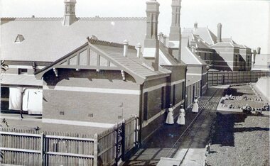
The brick buildings in the photograph are of the former Sunbury Asylum and F3 Ward is in the foreground. Initially the site on Jackson Hill also known as She0ak Hill opened as an Industrial School for orphaned or neglected children and in 1879 it became an asylum where it continued to function as an asylum until the Victorian Government closed it on 20th November 1992.The Sunbury Asylum played an important part in Sunbury and wider community's development over 150 years. throughout its existence there was much interaction between the residents, staff and local community, many of whom were employed at 'The Hill' as it was known locally. A sepia non-digital photograph of a large brick hospital building with three nurses standing outside it on a narrow pathway edging a garden bed. A picket fence is at the rear of the building enclosing a small yard where washing is drying on the line.sunbury asylum, jackson hill, caloola, sheoak hill, ward f3 -
 Surrey Hills Historical Society Collection
book, Beyond the garden wall: twenty-two gardeners and their gardens, 2008
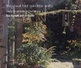
This book was compiled by Sue Barnett at the request of the project participants from material gathered as part of the project "Beyond the Garden Wall". This project was devised and managed by a team at Surrey Hills Neighbourhood Centre Inc. with funding from the Victorian Department of Planning and Community Development (VDPCD) under the "Images of Age' grant 2007. It involved conducting oral histories, reflection on the part of the participants through visual diaries, photography and painting. A short video of some of the gardens was also commissioned. All the elements came together during Seniors Festival in an exhibition held at the Augustine Centre, and opened by Jane Edmanson. At the request of the VDPCD, a modified exhibition was held in 2008 at 'Australia on Collins' during the 2008 Seniors Festival. Sue Barnett and Jo Reitze (Mrs de Carteret) are Surrey Hills residents. This provides a snapshot of 20 gardens and the 22 passionate gardeners who created them. The prose provides a potted history of the gardeners and their philosophical approach, accompanied by portraits of them and cameo photos of their gardens, as well as a photo of the painting of the garden as seen by artist Jo Reitze. All the gardens were situated within the City of Boroondara and all the gardeners were over 60 years of age. Prose written by Sue Barnett; photography by Sue Barnett and Jo Reitze.gardening, anecdotes, (ms) jo reitze, (ms) susan barnett, sue barnett, paintings, gardeners