Showing 835 items
matching subdivision plan
-
 Whitehorse Historical Society Inc.
Map, Subdivision Plan for part of Blackburn Park, c1910
... Subdivision Plan for part of Blackburn Park... 1903 - 1912. Subdivision Plan for part of Blackburn Park Map ...Photocopy of advertisement for sale of subdivision of area in BlackburnPhotocopy of advertisement for sale of subdivision of area in Blackburn between the railway line and Whitehorse Road between Station Street and Alfred Street. Some purchasers noted between 1903 - 1912.Photocopy of advertisement for sale of subdivision of area in Blackburnland subdivision, whitehorse road, blackburn, station street, blackburn, railway road, blackburn, queen street, blackburn, albert street, blackburn, chapel street, blackburn, george street, blackburn, cottage street, blackburn, alfred street, blackburn -
 Whitehorse Historical Society Inc.
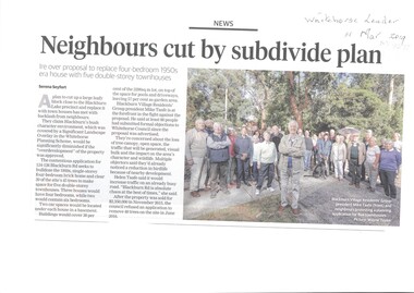
Article, Neighbours Oppose Subdivision Plan
... Neighbours Oppose Subdivision Plan... Subdivision Plan Article Article ...Neighbours are opposed to the removal of a 1950's house.Neighbours are opposed to the removal of a 1950's house to be replaced by 5 double-storey townhouses at 124 -126 Blackburn Rd which would require removal of 39 of the 45 trees on site.Neighbours are opposed to the removal of a 1950's house.blackburn, whitehorse planning scheme, blackburn road blackburn nos. 124 -126, blackburn village residents' group -
 Ringwood and District Historical Society
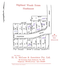
Document, Subdivision Plan - Highland Woods Estate, Heathmont, Victoria (undated, circa 1968)
... Subdivision Plan - Highland Woods Estate, Heathmont.... Subdivision Plan - Highland Woods Estate, Heathmont, Victoria (undated ...Map of 15 residential allotments for sale, with seven rubber-stamped SOLD and one with handwritten notation "$5650 1968". Subdivision includes Barrow Drive and Barnic Road, Heathmont. Agent - H.G. McLean & Associates Pty. Ltd., 166 Canterbury Road, Heathmont Vic., 3135, Telephones : 870-3422 A/hrs 870-5879. -
 Ringwood and District Historical Society
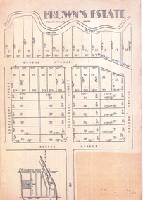
Flyer, Subdivision Plan - Brown's Estate, Ringwood, Vic
... Subdivision Plan - Brown's Estate, Ringwood, Vic.... subdivision of "Brown's Paddock". Subdivision Plan - Brown's Estate ...Buff-coloured single sided leaflet advertising subdivision of "Brown's Paddock".Subdivision includes Brown's Avenue (northern part later renamed Nelson Street), Montgomery Street, Churchill Street, Bond Street. Sole Agents - A.T. Miles & Son, 175 Whitehorse Road Rinwood. -
 Ringwood and District Historical Society
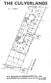
Document, Subdivision Plan - The Culverlands Estate, Heathmont, Victoria (undated, circa 1968)
... Subdivision Plan - The Culverlands Estate, Heathmont...-3422 A/hrs 870-5879 and 729-2809. Subdivision Plan ...Map of residential allotments for sale, with handwritten pricing notations and some marked "Sold". Subdivision includes Culverlands Road, Swain Court, Pleasant Drive, Barbara Court, and Armstrong Road, Heathmont. Agent - H.G. McLean & Associates Pty. Ltd., 166 Canterbury Road, Heathmont Vic., 3135, Telephones : 870-3422 A/hrs 870-5879 and 729-2809. -
 Ringwood and District Historical Society
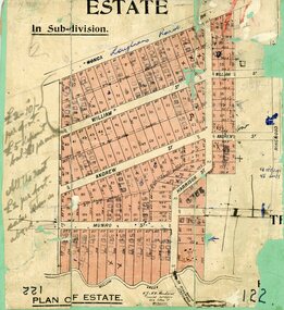
Map, Subdivision Plan, Loughnans Road, Ringwood - circa 1922
... Subdivision Plan, Loughnans Road, Ringwood - circa 1922... flyer). Subdivision Plan, Loughnans Road, Ringwood - circa 1922 ...Green card with cut-out map of residential allotments, some marked "sold". "Plan of Estate" includes Wonga Road, Loughnans Road, William Street, Andrew Street, Harrison Street, and Munro Street, Ringwood. (Surrounding area is part of Ringwood Park Estate featured in seperate 1922 auction flyer).Handwritten notations - (northern section) {£2-10/- per foot. £5 deposit bal £1 per month} All the rest £2 per foot, value same as above. Licensed Surveyors - W.J. & A.W. Kenhardt, 352 Collins Street, Melbourne. -
 Ringwood and District Historical Society
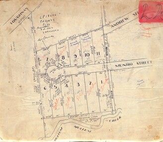
Map, Subdivision Plan of residential allotments in Munro Street, Ringwood, Victoria - (Undated, circa 1920s)
... Subdivision Plan of residential allotments in Munro Street... backing. Subdivision Plan of residential allotments in Munro ...Map of residential allotments on cardboard backing.Handwritten notations include sales information and title references LP1884, Vol 6602, Fol 132038, with number of units on lots 8, 9 and 10. -
 Ringwood and District Historical Society
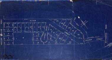
Map, Subdivision Plan of residential allotments in Mullum Mullum Road, Oliver Street and Lister Court, Ringwood, Victoria - (Undated)
... Subdivision Plan of residential allotments in Mullum Mullum... Subdivision Plan of residential allotments in Mullum Mullum Road ...Blueprint copy on cardboard backingNorth directional indicator includes name of Surveyor and Town Planner, Saxil Tuxen. -
 Ringwood and District Historical Society
Map, Subdivision Plan of residential allotments in Caroline Street, Thomas Street, Emerald Street and Ford Street, Ringwood, Victoria - (Undated, circa 1930)
... Subdivision Plan of residential allotments in Caroline... of residential allotments on blue cardboard backing. Subdivision Plan ...Map of residential allotments on blue cardboard backing.Handwritten title reference notation LP13641. -
 Ringwood and District Historical Society
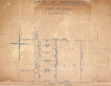
Map, Subdivision Plan of 5 residential allotments on Warrandyte Road and Oban Road, Ringwood, Victoria - (Undated - pre 1950s)
... Subdivision Plan of 5 residential allotments on Warrandyte... of Crown Allotment Map on cardboard backing Subdivision Plan of 5 ...Partial copy of Crown Allotment Map on cardboard backingParish of Warrandyte, County of Evelyn. -
 Ringwood and District Historical Society
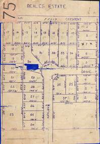
Map, Subdivision Plan of 37 residential allotments on Panorama Avenue, Felix Crescent, Evelyn Road and Avalon Grove, Ringwood, Victoria - (Undated - circa 1960)
... Subdivision Plan of 37 residential allotments on Panorama... backing Subdivision Plan of 37 residential allotments on Panorama ...Stencilled copy of map on blue cardboard backingBeales Estate -
 Ringwood and District Historical Society
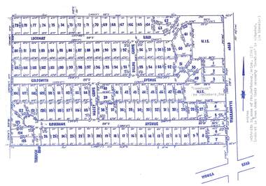
Map, Subdivision Plan - Rosebank Avenue area, North Ringwood, Vic. - circa 1960s
... Subdivision Plan - Rosebank Avenue area, North Ringwood.... Subdivision Plan - Rosebank Avenue area, North Ringwood, Vic. - circa ...Single page plan printed on green background showing allotments included in un-named subdivision layout surrounding "Rosebank" property, Warrandyte Road, Ringwood North. Subdivision includes Through Road, Rosebank Avenue, Macey Grove, Goldsmith Avenue, Dillon Grove, Lockhart Road, and Warrandyte Road.Typewritten notation against "Rosebank" property - "Mrs Godbehear, Snr.". "Goldsmith is maiden name of Mrs. Godbehear, Senior. (1960). Lockhart is town where their property "Rosebank" is situated. (In Riverina)". Additional Rosebank Avenue allotments blueprint clipping on light cardboard backing incldes handwritten title reference LP57659. -
 Ringwood and District Historical Society
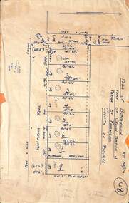
Map, Subdivision Plan - 8 residential allotments south of City Road on Wantirna Road, Ringwood, Victoria - (Undated - circa 1950s)
... Subdivision Plan - 8 residential allotments south of City... on cardboard backing. Subdivision Plan - 8 residential allotments south ...Hand-drawn map on cardboard backing.Part of Crown Portion 11, Parish of Ringwood, County of Bourke. Some allotments include real estate sales notations. (North arrow incorrectly points east.) -
 Whitehorse Historical Society Inc.
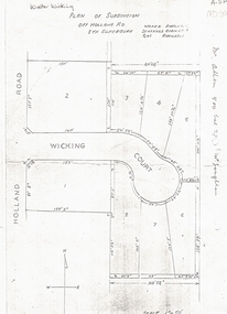
Document, Walter Wicking Plan of Subdivision, ?1952
... Walter Wicking Plan of Subdivision...Plan of subdivision for Wicking Court, South Blackburn.... wicking walter benjamin holland road Plan of subdivision ...Plan of subdivision for Wicking CourPlan of subdivision for Wicking Court, South Blackburn.Plan of subdivision for Wicking Courland subdivision, wicking court, blackburn south, wicking, walter benjamin, holland road -
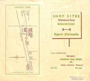 Ringwood and District Historical Society
Flyer, Ringwood Mail, Retail Subdivision Brochure - Plan of New Shop Sites, Ringwood, Victoria. - circa 1950
... Retail Subdivision Brochure - Plan of New Shop Sites... Subdivision Brochure - Plan of New Shop Sites, Ringwood, Victoria ...Double sided folded page advertising shop sites in Whitehorse Road, Ringwood, with locality plan, price list, terms of sale, summary of local facilities and services, and diagram showing layout of 9 retail allotments for sale. These sites were originally zoned as residential as part of the 1926 "Olive Grove Estate" subdivision. (See Vicorian Collections Reference 5169). The 9 new shops were later allocated street numbers 58 to 64 Whitehorse Road, Ringwood.Locality plan showing shop sites for sale on Whitehorse Road, Ringwood, between New Street and Olive Grove. Sole Agents: Ringwood Real Estate Co., Station Entrance, Ringwood, (Telephone) WU6661, WU6662. -
 Kew Historical Society Inc
Plan, J R Mathers & McMillan, Sackville, Thomas & Lytton Streets, Kew, Twentieth Century
... a substantial number of real estate subdivision plans, mainly of Kew...Lithographed subdivision plan for an un-named estate... number of real estate subdivision plans, mainly of Kew but also ...The Kew Historical Society's map collection includes a substantial number of real estate subdivision plans, mainly of Kew but also of surrounding suburbs in Melbourne. Most of the subdivision plans date from the 1920s and 1930s when the districts old homes and local farmland were being split up to accommodate residential growth in the postwar period. These early plans were assembled by a local firm, Jas R Mather & McMillan, which had an office in Cotham Road. Many of the plans, and sometimes photos, were annotated by the agents.Subdivision plans are historically important documents used as evidence for the growth of suburbs in Australia. They frequently provide information about when the land was sold as well as evidence relating to surveyors and real estate and financial agents. The numerous subdivision plans in the Kew Historical Society's collection represent working documents, ranging from the initial sketches made in planning a subdivision to printed plans on which auctioneers or agents listed the prices for which individual lots were sold. In a number of cases, the reverse of a subdivision plan in the collection includes a photograph of a house that was also for sale by the agent. These photographs provide significant heritage information relating house design and decoration, fencing and household gardens.The photograph may also be aesthetically significant depending on the importance of the photographic atelier.Lithographed subdivision plan for an un-named estate with 28 allotments facing Lytton, Sackville and Thomas Streets in Kew. The land would have originally formed part of the Dumaresq Estate. subdivision plans - kew, lytton street, sackville street, thomas street - kew -
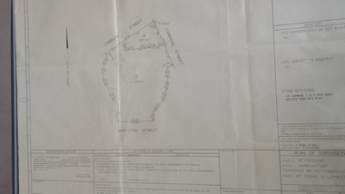 Peterborough History Group
Map - survey of Hamilton St wetland, Plan of Subdivision Hamilton Street
... Plan of Subdivision Hamilton Street...A3 plan of subdivision showing the outline of the swamp..., Charles St and Cumming St. Plan of Subdivision Hamilton Street Map ...Subdivided to preserve the wetland, locals estimate it occurred between 1976 and 1983A3 plan of subdivision showing the outline of the swamp bounded by Hamilton St, Charles St and Cumming St. peterborough, survey map, golden pond -
![7 Roomed Brick [villa]; Modern Conveniences](/media/collectors/550653872162f11fb04854aa/items/59ec3da221ea690fdc4ba793/item-media/59ec3ee521ea690fdc4d0c37/item-fit-380x285.jpg) Kew Historical Society Inc
Kew Historical Society IncPhotograph - 7 Roomed Brick [villa]; Modern Conveniences, 1920s
... a substantial number of real estate subdivision plans, mainly of Kew... is on the reverse of a subdivision plan for the Normanby Heights Estate, Kew.... number of real estate subdivision plans, mainly of Kew but also ...The Kew Historical Society's map collection includes a substantial number of real estate subdivision plans, mainly of Kew but also of surrounding suburbs in Melbourne. Most of the subdivision plans date from the 1920s and 1930s when the districts old homes and local farmland were being split up to accommodate residential growth in the postwar period. These early plans were assembled by a local firm, Jas R Mather & McMillan, which had an office in Cotham Road. Many of the plans, and sometimes photos, were annotated by the agents.Subdivision plans are historically important documents used as evidence for the growth of suburbs in Australia. They frequently provide information about when the land was sold as well as evidence relating to surveyors and real estate and financial agents. The numerous subdivision plans in the Kew Historical Society's collection represent working documents, ranging from the initial sketches made in planning a subdivision to printed plans on which auctioneers or agents listed the prices for which individual lots were sold. In a number of cases, the reverse of a subdivision plan in the collection includes a photograph of a house that was also for sale by the agent. These photographs provide significant heritage information relating house design and decoration, fencing and household gardens.The photograph may also be aesthetically significant depending on the importance of the photographic atelier.A professionally produced photograph for a local real estate agent, probably Jas. R. Mathers, Son & McMillan. The photograph is of a Federation-era bungalow, in Kew. The photo is on the reverse of a subdivision plan for the Normanby Heights Estate, Kew.The mount on which the photograph is placed includes: "Kew. 1 minute to tram. Good Position. / 7 roomed brick. Modern conveniences. / Land 60 x 135. 1100 pounds"real estate photographs, houses - kew, federation architecture -
 Kew Historical Society Inc
Photograph - 8 roomed DF Brick Villa, Kew, J E Barnes, c.1920
... Subdivision plans are historically important documents used... of the photograph is a subdivision plan for the Normanby Estate, East Kew... Subdivision plans are historically important documents used ...Subdivision plans are historically important documents used as evidence of the growth of suburbs in Australia. They frequently provide information about when the land was sold on which a built structure was subsequently constructed as well as evidence relating to surveyors and real estate and financial agents. The numerous subdivision plans in the Kew Historical Society's collection represent working documents, ranging from the initial sketches made in planning a subdivision to printed plans on which auctioneers or agents listed the prices for which individual lots were sold. In a number of cases, the reverse of a subdivision plan in the collection includes a photograph of a house that was also for sale by the agent. These photographs provide significant heritage information relating house design and decoration, fencing and household gardens. The photograph is of additional aesthetic significance as it was photographed by J. E. Barnes. Josiah Earl Barnes is a nationally significant photographer. He was also the most important photographer to have worked in Kew. He was active as a photographer in the district from c.1906 until his death in 1921. Best known as 'the Embarkation Photographer' (see the Australian War Memorial collection), J. Earl Barnes was also the official photographer employed by the Borough (and later Town, then City) of Kew. He clearly also completed commercial jobs for local businesses, as is the case in this photograph of a house for a local real estate and financial agent.A photograph, mounted on board of a double fronted Federation-era brick villa in Kew, photographed for a local real estate agent and financier by J. E. Barnes of Kew. On the reverse of the photograph is a subdivision plan for the Normanby Estate, East Kew - 2016.0039.1. As can be seen from the image, there is a large tear on the surface of the photograph.The brown card on which the photograph is mounted includes the following handwritten description, which may aid the identification of the house: "Kew, 3 minutes from tram, 8 roomed DF Brick Villa, tile roof including two attics, sleepout, bathroom, heater, E Light, Entrance Hall, double doors, leadlights, laundry, garden, lawns, land 75 x 170, 1975 pounds". Also photographers inscription on mount, lower left: J. E. Barnes / Photo / Phone 1966 Haw. KEW.j. e. barnes, josiah earl barnes, j. earl banes - photographer, architecture - federation style, houses - kew, real estate photographs -
 Whitehorse Historical Society Inc.
Document, Plan of Subdivision, 1861
... Plan of Subdivision...Copy of plan of subdivision by Patrick Riley of Section 77... of subdivision by Patrick Riley Copy of plan of subdivision by Patrick ...Copy of plan of subdivision by Patrick RileyCopy of plan of subdivision by Patrick Riley of Section 77, Parish of Nunawading 'Springfield Township' 1861. Bounded by Whitehorse Road, Walker's Road, (now known as Springvale Road) and Springfield RoadCopy of plan of subdivision by Patrick Rileyland sales, riley, patrick, whitehorse road, nunawading, walkers road, springfield road, black street, robertson street, sandy street, burnt street, luckie street, bridge street, creek street, koonung street, thompson street -
 Kew Historical Society Inc
Plan - Subdivision : Cotham and Glenferrie Roads, J R Mathers & McMillan
... a substantial number of real estate subdivision plans, mainly of Kew... (now Stirling Street). The plan predates the actual subdivision... number of real estate subdivision plans, mainly of Kew but also ...The Kew Historical Society's map collection includes a substantial number of real estate subdivision plans, mainly of Kew but also of surrounding suburbs in Melbourne. Most of the subdivision plans date from the 1920s and 1930s when the districts old homes and local farmland were being split up to accommodate residential growth in the postwar period. These early plans were assembled by a local firm, Jas R Mather & McMillan, which had an office in Cotham Road. Many of the plans, and sometimes photos, were annotated by the agents.Subdivision plans are historically important documents used as evidence for the growth of suburbs in Australia. They frequently provide information about when the land was sold as well as evidence relating to surveyors and real estate and financial agents. The numerous subdivision plans in the Kew Historical Society's collection represent working documents, ranging from the initial sketches made in planning a subdivision to printed plans on which auctioneers or agents listed the prices for which individual lots were sold. In a number of cases, the reverse of a subdivision plan in the collection includes a photograph of a house that was also for sale by the agent. These photographs provide significant heritage information relating house design and decoration, fencing and household gardens.The photograph may also be aesthetically significant depending on the importance of the photographic atelier.An undated and untitled hand-drawn and coloured subdivision plan detailing the boundaries of a number of irregular allotments bordering Cotham Road, Glenferrie Road and Stirling Avenue (now Stirling Street). The plan predates the actual subdivision that led to the creation of the eight commercial properties occupying 118-132 Cotham Road. The plan may represent an old subdivision that was further subdivided at a later date, or it may be a subdivision that never eventuated. On MMBW Detail Plan 1575 (1903), the area represented by the proposed subdivision was residential rather than commercial. The irregularity of lots is also apparent in the MMBW Plan. The largest of the unnumbered blocks on the hand-drawn subdivision plan may relate to the boundaries of the nineteenth century mansion identified as ‘Kelso’ on the MMBW Plan.subdivision plans - kew, cotham road - kew,, glenferrie road - kew , stirling avenue street - kew -
![Map, Plan of Subdivision of Crown Portion 23 & parts 24-25, Parish of Korkuperrimul [1900s?]](/media/collectors/5e461d8021ea67224c82f2a1/items/675fe058304668462205d4fb/item-media/675fe0ef304668462205d7d6/item-fit-380x285.jpg) Bacchus Marsh & District Historical Society
Bacchus Marsh & District Historical SocietyMap, Plan of Subdivision of Crown Portion 23 & parts 24-25, Parish of Korkuperrimul [1900s?]
... Plan of Subdivision of Crown Portion 23 & parts 24-25... directions from the township area. The date of the subdivision.... Plan of Subdivision of Crown Portion 23 & parts 24-25, Parish ...The Parish of Korkuperrimul includes a significant section of the township of Bacchus Marsh and extends in western and northern directions from the township area. The date of the subdivision indicated on this plan has not been established. The engineer's stamp on the drawing shows the firm of Muntz and Muntz who were operating under that name in the early part of the 20th century.A single page paper map showing 20 blocks of land for sale in the Parish of Korkuperrimul. Scale 100 feet to 1 inch. The map is pasted into a bound volume containing 76 maps or plans in total. High resolution digital image stored on BMDHS computer network. Stamped: 'Muntz & Muntz Civil Engineers, Architects & Surveyors, Trustees Chambers ?? Cor Collins Street and Bank Placeland sales bacchus marsh, bacchus marsh victoria maps, land sales korkuperrimul parish -
 Kew Historical Society Inc
Plan, F R Simms & Son, Land for Private Sale: Cnr Victor Avenue and Mont Victor Road, Kew, 1950-1960
... . The subdivision plan shows most of the lots in the entire subdivision: 1...Subdivision plan advertising five superb home sites among.... The subdivision plan shows most of the lots in the entire subdivision: 1 ...George Rimington established The Parkhill Nursery in 1877. By 1910, it was more commonly known as Rimington’s Nurseries and well known for its sale of violets. After World War II, Rimington’s Nurseries were gradually subdivided and sold. The 38 allotments were released in sections, including lots 34 to 36 on the corner of Mont Victor Road and Victor Avenue. Previous lots in the subdivision had bordered Burke Road, Rimington Avenue, Heather Grove, and Stoke Avenue. The selling point as it had been in comparable estates for a century were the proximity to transport, schools and churches, as well as the high location and excellent views. The subdivision plan shows most of the lots in the entire subdivision: 1-11, 13-26, and 34-38. Presumably, lot 12 and lots 27-33 were still to be released.Subdivision plans are historically important documents used as evidence of the growth of suburbs in Australia. They frequently provide information about when the land was sold on which a built structure was subsequently constructed as well as evidence relating to surveyors and real estate and financial agents. The numerous subdivision plans in the Kew Historical Society's collection represent working documents, ranging from the initial sketches made in planning a subdivision to printed plans on which auctioneers or agents listed the prices for which individual lots were sold. In a number of cases, the reverse of a subdivision plan in the collection includes a photograph of a house that was also for sale by the agent. These photographs provide significant heritage information relating house design and decoration, fencing and household gardens.Subdivision plan advertising five superb home sites among lots in Burke Road, Stoke Avenue, Victor Avenue, Mont Victor Road and Heather Grove.subdivision plans - kew, rimington avenue -- kew (vic.), heather grove -- kew (vic), stoke avenue -- kew (vic.), burke road -- kew (vic.), mont victor road -- kew (vic.) -
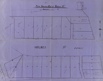 Federation University Historical Collection
Map, Plan subdivision: Allotment 12 Holmes Street, Ballarat
... Plan subdivision: Allotment 12 Holmes Street, Ballarat... is numbered - 20 in all Names on some blocks Plan subdivision ...The Allotments drawn in Holmes Street appear to be hand drawn and showing one of the first subdivisions in Ballarat. This was begun in the 1860s. Some names are marked on the blocks - Taylor (9), Holmes (6), Robert Watson (3), Watson (16), Walter (18),Wetherly (11), Vacant (7)Blue paper with black ink showing the land blocks either side of Holmes Street Each block is numbered - 20 in all Names on some blocksNorth indicated with arrow Sizes of blocks - depth and width holmes street, subdivision, allotment 12, holmes, taylor, robert watson, watson, wetherly, vacant -
University of Melbourne, Burnley Campus Archives
Plan, Ratio Consultants Pty. Ltd, Conceptual Subdivision & Garden Layout Plan Project 'Rosecraddock' Rosecraddock Place Caulfield, 1991
... Conceptual Subdivision & Garden Layout Plan Project..." subdivision plans landscape design Tracing paper plan by Ratio ...Tracing paper plan by Ratio Consultants Pty. Ltd., for Mr P. Shellard, Project No 1887, drawing No LS3, October 1991. Scale 1:250.p. shellard, caulfield, ratio consultants, "rosecraddock", subdivision plans, landscape design -
 Warrnambool and District Historical Society Inc.
Map, Plans (5) showing Subdivisions of Warrnambool, 1989
... ‘Subdivision Plan, Reference Guide, Steve Hester, Oct. 1989’. ... steve hester history ‘Subdivision Plan, Reference Guide, Steve ...These plans have been drawn by Steve Hester for the Warrnambool City Council to illustrate the allotments in Warrnambool concerned with the subdivisions of 1989. The streets have not been named but there is an indication of the area with the identification of known buildings (eg Hospital) and the plan numbers of each allotment is clearly marked. These numbers corresponded to the plan numbers registered in card files and ledgers in the Warrnambool City Council offices. The scale of the plans was 1 to 5000. These plans are of considerable interest because they show Warrnambool street subdivisions of 1989 in illustrative form. They show how information was collated in the late 1980s before the widespread use of computer digital means to describe and store information.These are five hand-drawn sheets showing plans of sub-divisions in Warrnambool streets in 1989 (Warrnambool City Council material). The plans are multi-coloured (crayons) and show allotments with plan numbers. The first plan has much of the material torn off but the location is known to be in the Russells Creek area. Some of the green tape around the edges is missing. Plans two to five are almost intact and are bound with green tape. Plan Two- Industrial Estate of West Warrnambool; Plan Three – Hospital/Merrivale/ Lake Pertobe areas; Plan Four – North Warrnambool, Wollaston/Brierly areas; Plan Five – Flaxman Street area. ‘Subdivision Plan, Reference Guide, Steve Hester, Oct. 1989’. warrnambool street subdivisions, steve hester, history -
Glenelg Shire Council Cultural Collection
Plan - Plan - subdivision at Cape Bridgewater, 02/04/1992
... Plan - subdivision at Cape Bridgewater...Black and white photocopy of an old plan of a subdivision... Cliff Street Portland great-ocean-road town planning residential ...Black and white photocopy of an old plan of a subdivision at Cape Bridgewater. In two halves, not joined together. Black texta numbers on some of the lots 1 - 28town planning, residential, cape bridgewater -
Glenelg Shire Council Cultural Collection
Plan - Plan - subdivision at Cape Bridgewater, n.d
... Plan - subdivision at Cape Bridgewater...Black and white photocopy of a 1990s plan of a subdivision... of a 1990s plan of a subdivision at Cape Bridgewater - 'Heritage ...Black and white photocopy of a 1990s plan of a subdivision at Cape Bridgewater - 'Heritage Valley'. Twenty-eight lots . In two halves, not joined togethertown planning, residential, sub divide, cape bridgewater -
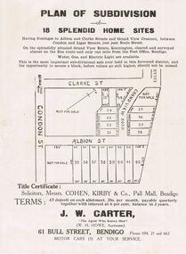 Bendigo Historical Society Inc.
Document - RANDALL COLLECTION: PLAN OF SUBDIVISION OF 18 SPLENDID HOME SITES, Sat. 18th May 1929
... RANDALL COLLECTION: PLAN OF SUBDIVISION OF 18 SPLENDID HOME...Document, Plan of Subdivision of 18 Splendid Home Sites... DOCUMENT J.B.Ross, Print, Bendigo Document, Plan of Subdivision ...Document, Plan of Subdivision of 18 Splendid Home Sites. Having frontages to Albion and Clark Streets and Grand View Cresent, between Condon and Ligar Streets, just pass Neale Street.Title Certificate: Solicitors, Messrs. Cohen, Kirby & Co, Pall Mall, Bendigo. J.W.Carter 61 Bull Street , Bendigo, ''The Agent Who Knows How''.J.B.Ross, Print, Bendigodocument -
![Map, Plan of Subdivision [Allotments along Lerderderg, George and McFarland Streets]](/media/collectors/5e461d8021ea67224c82f2a1/items/675d7243165f146b8adfc656/item-media/675d72d7165f146b8adfc859/item-fit-380x285.jpg) Bacchus Marsh & District Historical Society
Bacchus Marsh & District Historical SocietyMap, Plan of Subdivision [Allotments along Lerderderg, George and McFarland Streets]
... Plan of Subdivision [Allotments along Lerderderg, George... at the top of the map are the words, 'Plan of Subdivision of Cr Pors... at the top of the map are the words, 'Plan of Subdivision of Cr Pors ...This map shows allotments of land on the northern side of Lerderderg Street from Gisborne Road through to the approximate site of the present day Bacchus Marsh Primary School. There are also allotments shown on the southern side of McFarland Street between George Street and Gisborne Road. Larger allotments of land are shown extending northwards towards Masons Lane. Inscribed at the top of the map are the words, 'Plan of Subdivision of Cr Pors (Crown Portions) 12 & 13 & Allotments 1,2,3,4, Block 3, Parish of Korkuperrimul, County of Bourke'. The date of the map has not been established but the absence of the Bacchus Marsh Primary School on the map suggests it may have been produced prior to 1865 when the primary school was built in Lerderderg Street.Single page map showing house block size land allotments in the Lerderderg, George Street and McFarland Street area of Bacchus Marsh with larger allotments north of this area towards Masons Lane also shown. Scale 150 feet to 1 inch. Part of a set of maps which are pasted into a bound volume containing 76 maps or plans in total. High resolution digital image stored on BMDHS computer network. bacchus marsh victoria maps, lerderderg street land allotments, mcfarland street land allotments