Showing 10915 items
matching the land
-
 Bendigo Historical Society Inc.
Administrative record - Reports of sales by auction
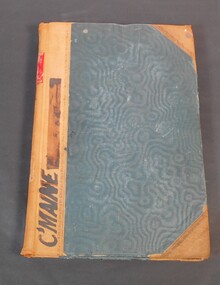
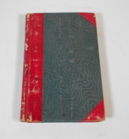
Blue book with brown corners and spine, red label on spine with the title in gold letters "Reports of sales by auction". Letter "C" on spine. C'Maine on front cover. The book contains official Crown land sales documents, the papers are glued into the book. The book contains the purchasers' names, land section, allotments and price. Cover the period from 1893 to 1905.11/1/1893 to 12/03/06 written on the spine. Land sale reports 1880 written on inside cover. land sales, crown land, auctions -
 Whitehorse Historical Society Inc.
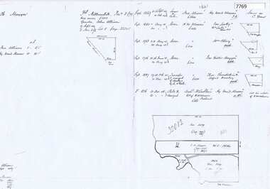
Letter - Correspondence, John McClelland, 1905
Letter to John McClelland from solicitors in 1905 regarding the transfer of land to members of his family.Letter to John McClelland from solicitors in 1905 regarding the transfer of land to members of his family. Land was north and south of the railway in Tunstall (sketch).Letter to John McClelland from solicitors in 1905 regarding the transfer of land to members of his family. mcclelland, john, mcclelland family, tunstall -
Whitehorse Historical Society Inc.
Book, Aboriginal Melbourne, 1998
Subtitled 'the lost land of the Kulin people.Subtitled 'the lost land of the Kulin people. Previously published as 'The Land of the Kulin', 1985. Author's presentation copy to Ted and Valda Arrowsmith.Subtitled 'the lost land of the Kulin people. aborigines, kulin -
 National Wool Museum
Leaflet
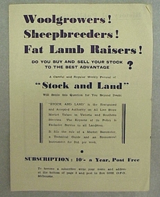
Subscription leaflet and application for "Stock and Land" newspaper.Subscription leaflet and application for "Stock and Land" newspaper.Geelong 848594 6/- 20/11 Prahran B893271 6/- 13/2/46agriculture - news, stock and land, woods, mr george -
Ringwood and District Historical Society
Land titles and plan, Victorian Titles Office, Titles and plans of Ringwood Land between Mullum Land and Wonga Rd. (Re Ann Jane Kennedy). 1907, 1-Oct-07
The documents pertaining to Ann Jane Kennedy inheriting the land from her late husband Samuel John Kennedy and the history of the transfers of land from Ann Jane Kennedy in 1907 until the title was cancelled in 1925 to James Melbourne Ross. The area was 10 acres between Mullum Mullum Road and Wonga Road retrieved from Titles Office.Ten pages of photocopied titles and plans of land in Ringwood between Mullum Road and Wonga Road, also transfer of original land. -
 Federation University Historical Collection
Map - Documents, Documents relating to Land - Selection of Maps of subdivisions; Titles; Cemetery sections
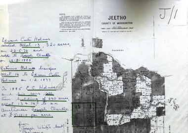
Maps indicate the land owned in various areas of Victoria - Mornington Peninsula, Ascot / Creswick areaLand maps showing block divisions and owners. Edward Carter Holmes J.P. selected land and called it Launchley - later called Wambalano.jeetho, county of mornington, edward carter holmes, joseph clarke, catherine holmes, talbot, william coghill, pre-emptive right, tourello pre-emptive right, glendonald pre-emptive right, clunes, smeaton, ascot, counties of ripon and talbot, certificate of title, ballaarat general cemetery, new cemetery, poowong, helen coghill -
 Kiewa Valley Historical Society
Report - Alpine Study Area Volume 2 Maps, Land Conservation Council, 1970s
The Victorian Environmental Assessment Council and the former Environment Conservation Council (ECC) and Land Conservation Council (LCC) have completed 36 land use investigations over more than 35 years, including 27 regional reviews. They provide a framework for use of Public Land in Victoria. The Land Conservation Council was established by the Land Conservation Act 1970.These maps provide an assessment of the Alpine area at the time the maps were created. Some of the topics eg. Rainfall and water resources may change over the years thus providing a comparative analysis. Others may provide information for future development such as mineral exploration, building of a dam / tunnel etc.Blue box shaped folder containing 9 of 10 Maps of the Alpine Study Area produced by the Land Conservation Council. Maps include 1. Public land and descriptive blocks. 2. Physiography. 3. Topography. 4. Geology (missing). 5. Rainfall and water resources. 6. Vegetation 7. Land systems. 8. Recreation. 9. Primary production. 10. Minerals Ex library item. Stamped in red "Discarded From Stock / Swan Hill Regional Libraryalpine area, maps of alpine area, land conservation council -
Marysville & District Historical Society
Map (item), Taungurung Land and Waters Council Aboriginal Corporation, Unknown
A map of the area in Victoria which is the land of the Taungurung Clan.A map of the area in Victoria which is the land of the Taungurung Clan. Taungurung Land and Waters Council (TLaWC) was registered 16 July 2009 as the Registered Aboriginal Party that represents the interests of the Taungurung people. TLaWC is the corporate representative and ‘face’ of the Taungurung people and serves to uphold their interests with respect to culture and country. The Taungurung people occupy much of central Victoria. Their country encompasses the area between the upper reaches of the Goulburn River and its tributaries north of the Dividing Range. From the Campaspe River to Kilmore in the West, eastwards to Mount Beauty, from Benalla in the north down to the top of the Great Dividing Range, their boundaries with other Aboriginal tribes are respected in accordance with traditional laws.taungurung clan, taungurung land and waters council aboriginal corporation, victoria -
Tatura Irrigation & Wartime Camps Museum
Poster, Subdivision of Township Allotments
Poster depicting the land which was being sold by J S Darby on the 3 December 1890. Auctioneer was Martin Cussen and Co. Map shows location of land.Single sheet of paper, laminated. Advertising land subdivision for sale in the township of Rushworth. Being sold by Martin Cussen and Co, auctioneers for J S Darby. Shows map of land subdivision.rushworth, land subdivision, martin cussen and co, j s darby -
 Wangaratta RSL Sub Branch
Badge - Boxed badge, 2012
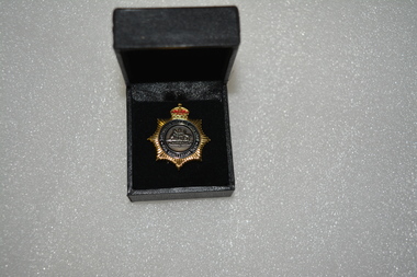
Badge received by Dorothy Kiely in 2012 on the 70th anniversary of the Australian Women's Land Army. The Australian Women’s Land Army (AWLA) was formed during the Second World War to combat rising labour shortages in the farming sector. From December 1941, when Japan entered the war, the nation’s need to build up its armed forces was placed above the needs of other industries. Agricultural labour was steadily diverted to the armed services and war industry To meet the shortfall in rural labour, State and private women’s land organisations were organised, modelled on those established in Great Britain during the First and Second World Wars. A national body was formed on 27 July 1942 under the jurisdiction of the Director General of Manpower. While policy was devised by the Commonwealth Government, the organisation of the AWLA remained State-based. An extensive recruiting campaign was undertaken for new members. Most members of the existing land armies were later incorporated into the AWLA as well. Black box containing gold star shaped badge with red crown above Australian coat of arms Badge:-Australian Women's Land Army 70th Anniversary 2012 Box:- top in gold lettering 70th Anniversary of the Australian Women's Land Armyawla, ww2, dorothy kiely -
Whitehorse Historical Society Inc.
Article, Land Which Overlooks Dandenongs, 1935
Sale of Land which overlooks Dandenongs.Land which overlooks Dandenongs : Real Estate is reviving between Box Hill and Croydon. Article on Box Hill to Croydon land development 1935.Sale of Land which overlooks Dandenongs.eastern suburbs, melbourne, real estate, transport, local government -
Whitehorse Historical Society Inc.
Article, Traders Trapped, 1985
Eight Businesses at Houston Shopping Centre, Middleborough Road, Box Hill.Eight Businesses at Houston Shopping Centre, Middleborough Road, Box Hill, facing rezoning of land reserved for the Healesville Freeway. Traders say they are being treated unfairly by the Road Construction Authority, owner of the land.Eight Businesses at Houston Shopping Centre, Middleborough Road, Box Hill. land use, anderson camp -
Glenelg Shire Council Cultural Collection
Photograph - Photograph - Portland Harbour, 1960-1966
Port of Portland Authority archivesFront: (no inscriptions) Back: Valuable reclaimed industrial land alongside main shipping berths at Portland (typed on sticker, centre)port of portland archives, aerial photography, portland harbour -
 Greensborough Historical Society
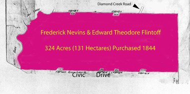
Folder of documents, Flintoff - various documents, 1844_
Records the Flintoff family's ownership of parcels of land in the Greensborough area. Includes a survey plan for acquisition of land for the aqueduct 1897.Various photocopies of title documents relating to land owned by the Flintoff family in Greensborough.Mainly handwritten documents dating from early 20th century.flintoff family, land titles, greensborough, aqueduct -
 Halls Gap & Grampians Historical Society
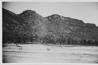
Postcard - B/W
The Wonderland range from the Halls Gap side. the cleared land was used for grazing purposes.Photo shows peaks in background with cleared land in the foregroundPost Card Correspondence Address 122 Grampiansscenery, wonderland range -
 Dandenong/Cranbourne RSL Sub Branch
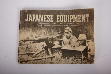
Booklet - Book, Japanese Equipment, Japanese Equipment
Recorded inside -: Pte AB Bishop ux37033 2/2nd Info Bn.Small Booklet containing Photographs and Characteristics of Basic weapons Encounted In SWPA. It is a pocket book 14cm x10cm of 50 pages detailing many items including -: flags and badges, pistols ,rifles grenades,various guns, bombs, land mines, flame thrower, tanks, tanks and mortars. Dated June 1943. Book belonged to VX37033 Andrew Bishop.GS(INT). ADV HQ ALLIED LAND FORCES SWPA NOT TO BE PUBLISHED. -
 Ballarat Heritage Services
Photograph - Colour, Clare Gervasoni, Church Avenue, Hepburn Springs, from Bellinzona, 2004, 28/06/2004
The block of land depicted has been leveled with a huge rock barrier around the corner perimeter.Block of land on the corner of Borsa Crescent and Seventh Street.bellinzona, actea, hepburn springs, church avenue, seventh street, borsa crescent -
 Greensborough Historical Society
Aerial Photograph, Flintoff land - View from above, 1945_
Section of the 1945 Greensborough aerial survey, focusing on the land belonging to the Flintoff familyPhotocopy of section of 1945 aerial survey of Greensborough area"Flintoff land to west of Diamond Creek Rd" written in pencil on backflintoff family, aerial photograph -
 Ringwood and District Historical Society
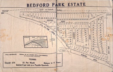
Plan - Sub-division, Bedford Park Estate, Ringwood, Victoria - 1924
Bedford Park subdivisional development did not eventuate. The land adjoining the railway line became parkland with provision for sporting facilities and the remainder was purchased by the Education Department as the site for Ringwood High School/Secondary College. Poster size land sale advertisement.Subdivision plan includes Bedford Road, Graham Road, Joyce Street, Anderson Street, and Adams Street. Solicitors - W.R.R. Blair, Son & Falconbridge, 405 Collins Street, Melbourne. -
 Bacchus Marsh & District Historical Society
Map, Plan of the property of Messers Atkins and Clarke to be sold at the Mansion, Bacchus Marsh 19th April 1856. Copy 1
This plan of land allotments for sale indicates the property once owned by the Bacchus family in and around the township area of Bacchus Marsh. The Bacchus family sold their property in Bacchus Marsh to John Atkins and Robert Nalder Clarke in March 1851. Atkins and Clarke kept the property for a number of years until April 1856 when these allotments were put up for sale.This plan is almost identical to another copy held by the Bacchus Marsh and District Historical Society, VC Record 452, BMDHS collection). This plan, VC Record 707 Copy 1, contains a little more detail overall than VC Record 452 Copy 2, such as who did the survey work for the plan (R.C. Bagot) and who the selling agents were, (W.M. Tennent), and on the right side of the plan near the Lerderderg River is indicated the general area for a second parcel of land from this sale which is to be sold. There is also a compass illustration indicating north and south compass points.This is a very early land sales plan for the township of Bacchus Marsh and it therefore provides some clues as to how the early urban development of the township took place. Upon seeing the map in 1911 Bacchus Marsh Express newspaper editor Christopher Crisp wrote "The sale appears to have created the present township, which had a nucleus in earlier times further east", Express, 30 September, 1911, page 3.A single page paper plan showing allotments of land for sale. The subdivided land shown was owned by John Atkins and Robert Nalder Clarke, but previously owned by the Bacchus Family and was in and around their Manor House (Mansion) property in Bacchus Marsh.There are 5 portions of land further divided into numerous small portions. The land for sale is bounded by the present day streets of Main Street, Young Street, McFarland Street, Morton Streets, Crook Street, and part of the eastern section extends to the Lerderderg River. Scale: 8 chains to 1 inch The plan is pasted into a bound volume containing 76 maps or plans in total. BMDHS Loc: AR/B12/S4 Bacchus Marsh Township and Nearby Districts Maps Volume In-house Digital copies: BMDHS, Computer Network: Maps\Bacchus Marsh Township and Nearby Districts Maps VolumeHeading: Plan of the first portion of land. The property of Messers Atkins and Clarke situate at Bacchus Marsh. To be sold by W.M. Tennent & Co. at the Mansion on the Ground on Saturday the 19th April 1856. Below heading: Jas Ferguson, Lithographer On upper right side: Subdivided by R.C. Bagot London and Liverpool Chambers, Melbourne. 'Thos Taubman'. Post Office Stamp: BACCHUS MARSH VICTORIA MY 6, 63bacchus marsh victoria maps, bacchus family, land sales, manor house bacchus marsh -
 Kew Historical Society Inc
Photograph - Flooding of shared path at rear of Guide Dogs Victoria, 1993
The land currently occupied by Guide Dogs Victoria was once part of the grounds of the Kew Lunatic Asylum. This includes the land, designated as parkland which adjoins the Yarra River. Original colour small format polaroid photograph of flooding in parkland at the rear of Guide Dogs Victoria in the area now used as the Main Yarra Trail; taken on 16 September 1993."Flooding of shared path on 16.9.93 / Rains 15.9.93 - rear Guide Dogs [Victoria] land"yarra river -- floods -- kew (vic.), guide dogs victoria, main yarra trail, chandler park -
 Greensborough Historical Society
Document collection, Copies of Poulter family documents, 1880o
Records some land ownership, birth, deaths and marriages of the Poulter family of Greensborough. Dates from 1880s.Copies of documents, land titles and birth, death and marriage certificates.Mainly handwritten records.poulter family, land titles, greensborough -
 Uniting Church Archives - Synod of Victoria
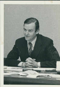
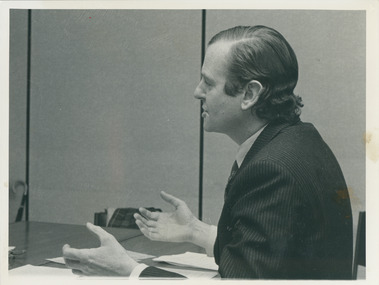
Photograph, Hugh Morgan, 1984
The article was the cover story of a discussion between Morgan and the Rev. Dr D'Arcy Wood regarding Aboriginal land rights in C&N for July 25, 1984.Photograph of Hugh Morgan as part of an article on land rights.Identification of Hugh Morgan.land rights, morgan, hugh, wood, d'arcy -
 Uniting Church Archives - Synod of Victoria
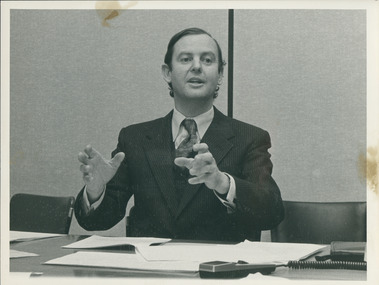
Photograph, Hugh Morgan, 1984
The article was the cover story of a discussion between Morgan and the Rev. Dr D'Arcy Wood regarding Aboriginal land rights in C&N for July 25, 1984.Photograph of Hugh Morgan as part of an article on land rights.Identification of Hugh Morganland rights, morgan, hugh, wood, d'arcy -
Whitehorse Historical Society Inc.
Letter - Correspondence, Obtaining a grant of Crown Land at rear of Myrtle Grove, 1932
Correspondence between Council and Closer Settlement Board re land in Pakenham Street including plans of allotments.Correspondence between Council and Closer Settlement Board re land in Pakenham Street including plans of allotments. Also further correspondence re land being sold by Malcolm Sheehan to Dal Hear.Correspondence between Council and Closer Settlement Board re land in Pakenham Street including plans of allotments.pakenham street, blackburn, myrtle grove, blackburn, shire of blackburn and mitcham, sheehan, malcolm, hearn, dal, victoria. closer settlement board -
 Phillip Island and District Historical Society Inc.
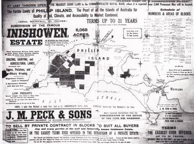
Map & Newspaper clipping, The Argus, Inishowen Estate, c1910 and 3/11/1868
Selection of land on Phillip island. Early subdivision of "Inishowen" Estate.449-01: Map of Phillip island showing "Inishowen" Estate c 1910 449-02: Newspaper article on the selection of land plus listing of people who obtained land. Argus 03/11/1868.inishowen estate phillip island, phillip island land selection 1868 -
 Otway Districts Historical Society
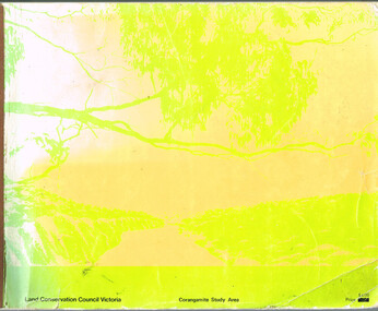
Book, Land Conservation Council, Report on the Corangamite Study Area, May 1976
The Report describes and assesses the natural resources of public land in the Corangamite study area, and provides a factual basis on which members of the community may base their submissions to the Council.Report on the Corangamite study area. Land Conservation Council. Melbourne; Land Conservation Council; May 1976. x, 310 p.; illus, maps (separate). Soft cover.land conservation council; corangamite; geology; physiography; climate; water resources; soils; vegetation; fauna; -
 Bendigo Historical Society Inc.
Administrative record - Lands Office Bendigo - Residence area applications
Green and red hardbound book. It contains handwritten details of applications of residence area licenses under part II of the land's act 1869. It covers the period from 02-11-1881 to 25/11/1881.Application Register part 2, land act 1869 on the spine. On the first page in pencil: Soloman Paul, Hill Street Sandhurst.land office, residence area licenses -
 Greensborough Historical Society
Document - Certificate of Title, Alison land, 1840o
Land originally granted to John Alison 09/09/1840. Shows chain of ownership from Alison to Lecky, Mayger (Magyar) and Blay; Lecky to Charles Buck; Mayger to Whatmough.Shows part of the chain of ownership of this parcel of land in Greensborough.4 pages. Copies of land titles and associated documentsSome annotations by Noel Withersland titles - greensborough, mayger family, whatmough family