Showing 980 items matching "victoria square"
-
 Kiewa Valley Historical Society
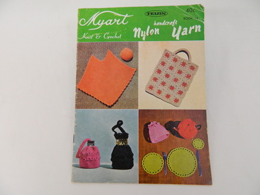
Book - Country Women's Association of Victoria, Myart Knit & Crochet
This book was used by members of the Tawonga C.W.A.. The group exhibited their handicrafts and made items for charity. The Tawonga branch of the C.W.A. commenced on the 7th Feb. 1946 and often combined activities with the other branches in the Kiewa Valley. The C.W.A. aimed to improve health, welfare and education for women and children in the country.Women living in Tawonga were mostly on farms and, in 1946, when the branch commenced would have been feeling more remote with WW11 having had an effect on available workers and the well being of the women and children.Small coloured 16 page book with a cover showing 4 squares of knitted and crocheted items. At the top the book has a light green background with white writing and some black writing. The back cover is similar with 4 different items. The book is bound with 2 staples. The book has patterns with instructions for knitted & crocheted items.Cover: 'Myart / Knit & Crochet' - on left. 'Handcraft / Nylon Yarn' - on right. 'Teijin 40c / Book 14' - top right in blackcountry women's association of victoria. tawonga. handcrafts. knitting. crocheting. -
 Kiewa Valley Historical Society
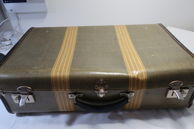
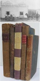
Case with Books x9 - 1930s to 1950s, 1. The Lawsons by Gwen Meredith 2. A Many Splendoured (sic) Thing by Han Suyin 3. Reach for the Sky by Paul Brickhill 4. My Fair Lady 5. Brownies at St. Bride's by Ethel Talbot 6. The Children's Treasure House 7. Complete Household Guide 8. The Royal Tour of Australia and New Zealand in Pictures 9. Under Southern Skies Victoria ..Australia
These books are all old and belonged to local families in the Kiewa Valley. Reading was a major form of entertainment from the 1930s before TV was available.These books give an insight into the interests of families in the Kiewa Valley prior to the invention of TV.Case - Stiff cardboard, yellow & green with two yellow strips on outside. Inside blue squares. Metal handle attached. Fastened by two sliding locks one at each end and each with a key hole. There is a clip/clasp in the front centre. Books: Nos. 1-4 A collection of x4 medium size novels belonging to Vera Hore; No. 5 x1 belonging to Jessie Hollonds, Tawonga and is a small book with coloured cover. No. 6. large red book No. 7. a large yellow/brown book No 8. a large hard covered red book with x2 gold lions on front No 9. colored cardboard cover with spiral spineCase - Label on the lid inside and centre top: 'Made by/ Permacase/Melbourne, Victoria/Aero Tweed Books: 1-4 Mrs Vera Hore / Bogong Hotel / Tawonga inscribed on front page 5. Lois Jessie Hollonds, Tawonga "To dear Lois / With best wishes / from Nancy / Xmas 1934 inscribed on front page 6. Dorothy Maureen Ryder / Tawonga / 1-10-35 inscribed on front page 7- - 9. nilhore family tawonga hotel, hollonds family, old books, royal tour 1950s -
 Kiewa Valley Historical Society
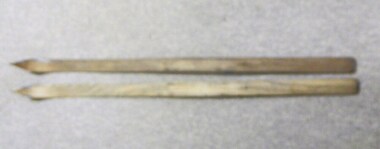
Skis, 1944-45
Skiing was first done at Falls Creek with the building of the towns of Bogong and Mt Beauty. European workers to the Hydro scheme thought that Falls Creek would make a good skiing village. The first ski lodge being opened in 1947. These skiis would have been used in those first seasons of Falls Creek and used by the first skiers of the time from 1945 onwards.These skiis are historically and socially significant, as they would have been one of the first type of skiis used at Falls Creek, one of Victoria first ski resorts, and used by the pioneers of skiing in Victoria. This item has good interpretive capacity as it shows the style of skiis that were used in the 1940's and they are a good comparative item against modern skiis. These skiis were used by Bill Bertram during the first winter traverse from Mount Hotham to the Mountain Creek base of Mount Bogong, see KVHS 0161 for biography of this historical event.Painted Red base with blue undercoat with center groove from base to 3/4 of way towards tip At tips are square pices with round holes possbily HOME MADE? 21 plus 2 holes on top face (for binding)sport, pioneers, snow, skiis, skiing, falls-creek, bogong-village, mt-beauty -
 Kiewa Valley Historical Society
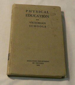
Book - Teacher Reference, Wilke and Co P/L, Physical Education for Victorian Schools, 1946
This book would have been used for physical education for schools all over Victoria from 1946 onwards. It has a very good foward by HP Kelly MB BS Medical Inspector of Schools stating the importance of pyshical movement and sport which is still trying to be installed into children today! This book cover all ages of children from infants to sixteen year olds. This book has social and historical significance because it shows the games, sorts, exercises, and gymnastics, swimming, dancing and rhymes that were done in the mid 20th century. This shows that teachers were aware of the importance of PE during this time. Many of these principles are still being taught today and with so many children in Victoria being obese through lack of exercise, this is very topical book! It was used by Bogong State School which had a very active PE education and therefore makes it very good interpretive capacity, It is the only book of this type in our collectionThe book is covered in light brown material with black writing on the front cover and spineHas a library marking number on the spine, 613, edu.1 in white paint on a black square. The inside cover has a purple stamp State School 4590 Bogong Vic and the number 2170 in pen. On the back cover has got 613 Edu.1 in pencilbook, school, teaching, pyhsical-education, education-department-of-victoria, teachers-aid, bogong state school -
 Kiewa Valley Historical Society
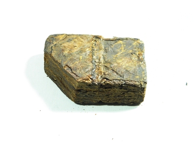
Plug Tobacco, Circa 1900s
This item (tobacco plug, as it was referred to) was used as a smokeless digestion of nicotine from the tobacco leaf. It was harvested by the tobacco growers before tailor made cigarettes became available. It was mainly regarded as more of a male item as it required to expectorate unwanted mouth juices. Ladies rarely used chewing tobacco. Most hotels and drinking rooms (men only in this era) had special spittoons to catch the waste.This item was used at a time when it was socially acceptable to chew tobacco (1800s to early 1900s). The associated health problems (lung and other related cancers including emphysema) eventually became the social and political incentive to curb the tobacco industry in the Kiewa Valley. Harvesting tobacco also had extreme risks such as "Green Tobacco " sickness. In Victoria the economical viability of the tobacco industry was extinguished in 2006. The tobacco drying sheds are still standing in the Kiewa Valley and in nearby regions. This item was also used by miners underground retrieving gold.This work environment was strictly a non smoke one.Square (small corner cut off) of compressed tobacco leaves, brown in colour and dried. Known at the time of use as a Plug.tobacco, chewing, plug, nicotine, smokeless, rural industry -
 Warrnambool RSL Sub Branch
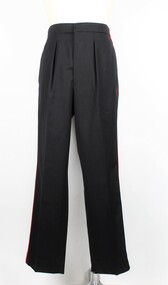
Dress Trousers Army Reserve, Fletcher Jones & Staff, 1998
... Inscriptions on the larger square label: Fletcher Jones... on the larger square label: Fletcher Jones / Victoria / 1998 / NSN: 8405 ...This jacket is part of the dress uniform of a Major in the Army Reserve. Major Bernard Farley who owned this jacket wore it to official functions in the Mess dining room. He served in this capacity from 1998-2001. Bernard also served in the RAAF for a number of years.These trousers are part of the dress uniform of a Major in the Army Reserve. Major Bernard Farley, who owned the uniform, wore it to official functions in the Mess dining room. He served in this capacity from 1998-2001. Bernard also served in the RAAF for a number of years.Long black trousers with a single red stripe running down either side from the top of the waistband to the base of the legs. There are two pockets just eunderneath the waistband on either side of the trousers. The fabric frms two stiff peaks at the centre of the back of the waistband. The trousers have a black zip with a metallic clip just above and six black plastic buttons along the interior of the waistband. There is one white square label with inscriptions attached to the back/left of the interior section of the waistband. Directly underneath this is another rectangular white label of the same length however much shorter. This also has inscriptions.Inscriptions on the larger square label: Fletcher Jones / Victoria / 1998 / NSN: 8405-66-095-9737 / NAME........... / SERVICE NO............ / 70% Wool / 30% Polyester / DRY CLEAN ONLY (A) / Press on original creases. Use damp cloth. Medium to hot iron / ZT782 AR0009 Inscriptions on the smaller rectangular label: 425267283.ZT782G / 94-92-76 / 347 044 07063222 / CLOTH / AR0009 / . . 5 . D40. 5 / J10066. . W *army reserve, dress uniform, dress trousers, trousers, army uniform, uniform, bernard farley, farley, warrnambool rsl, warrnambool -
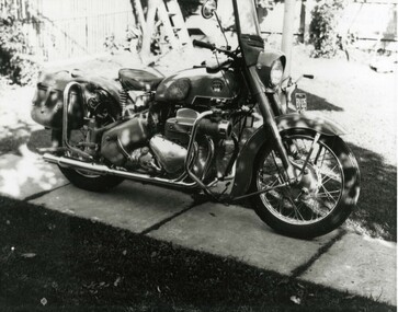
 Victoria Police Museum
Photograph (police motorcycle)
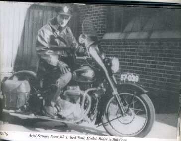
Senior Constable Bill Gore on a 1953 Ariel Square 4 motorcyclepolice vehicles; gore, william; police motorcycles; ariel square four motorcycle -
 Victoria Police Museum
Photograph (police motorcycle)
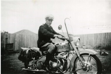
John Pollock on Ariel Square Four in back yard. Clothes line in background. Circa 1956police vehicles; wireless patrol; motor transport branch; motor transport section; motor cycle patrol; police motorcycles; ariel square four motorcycle; pollock, john -
 Victoria Police Museum
Photograph (police motorcycle)
Ariel Square 4 MkII, registration number BV-035, without rider. Circa 1958police vehicles; wireless patrol; motor transport branch; motor transport section; motor cycle patrol; police motorcycles; ariel square four motorcycle -
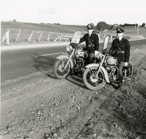 Victoria Police Museum
Photograph (police motorcycle)
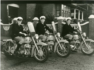
Two Ariel Square Four Mark IIs with riders on country road. Circa 1954police vehicles; wireless patrol; motor transport branch; motor transport section; motor cycle patrol; police motorcycles; ariel square four motorcycle -
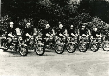 Victoria Police Museum
Photograph (police motorcycle)
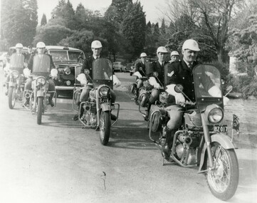
Seven Ariel Square Fours lined up, bearing flags with crown and Southern Cross, with riders mounted on their bikes. Circa 1956police vehicles; wireless patrol; motor transport branch; motor transport section; motor cycle patrol; police motorcycles; ariel square four motorcycle -
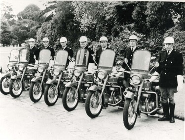 Victoria Police Museum
Photograph (police motorcycle)
Seven Ariel Square Fours lined up bearing flags with crown and Southern Cross, with riders standing beside their bikes. Circa 1956police vehicles; wireless patrol; motor transport branch; motor transport section; motor cycle patrol; police motorcycles, ariel square four motorcycle -
 Victoria Police Museum
Photograph (police motorcycle)
Ariel Square Fours escorting a vehicle through Botanic Gardens, possibly from Governor's residence. Circa 1956police vehicles; wireless patrol; motor transport branch; motor transport section; motor cycle patrol; police motorcycles; ariel square four motorcycle -
 Victoria Police Museum
Photograph (police motorcycle)
Three Ariel Square Fours with two of the riders being Bob Scott and John Johnston. Circa 1960police vehicles; wireless patrol; motor transport branch; motor transport section; motor cycle patrol; police motorcycles; ariel square four motorcycle -
 Orbost & District Historical Society
menu, 1912
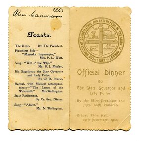
This item is an invitation to a dinner given by the Shire President and Mrs Hugh Cameron for the State Governor and Lady Fuller to be held in the Orbost Shire Hall on November 19, 1912. The governor and his wife left Melbourne on November 14 on a visit to East Gippsland. Hugh Cameron (1850-1921) was on the Orbost Shire council from 1892-1915. (more info. in O.D.H.S. newsletter -Tambo Shire) The Shire of Orbost was a local government area about 380 kilometres east of Melbourne, the state capital of Victoria, Australia. The shire covered an area of 9,347 square kilometres (3,608.9 sq mi), and existed from 1892 until 1994. Originally, Orbost was part of the Bairnsdale Road District which was created on 30 April 1867. Splitting away as part of the Shire of Tambo in 1882, Orbost was first incorporated as a shire in its own right as the Shire of Croajingolong on 30 May 1892. It received its present name on 17 February 1893. On 3 January 1913 part of its western riding was annexed to Tambo as its Cunninghame Riding. On 2 December 1994, the Shire was abolished, and merged with City and Shire of Bairnsdale, Shire of Tambo, most of Shire of Omeo and the Boole Boole Peninsula from Shire of Rosedale into the Shire of East Gippsland. This item is associated with Orbost Shire Council which no longer exists. It is also associated with Hugh Cameron.A small menu on a cream folded card with blue print. On the front is stamped a large blue logo of the Shire of Orbost. The text is "Official Dinner". On the back is a list of toasts and inside is the menu.On back - handwritten - "Alex Cameron"orbost-shire-council cameron-hugh -
 Orbost & District Historical Society
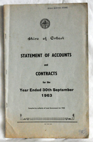
statement of accounts, Shire of Orbost Statement of Accounts, 1963
This document was made by the Shire of Orbost, local government. The Shire of Orbost was a local government area about 380 kilometres (236 mi) east of Melbourne, the state capital of Victoria, Australia. The shire covered an area of 9,347 square kilometres (3,608.9 sq mi), and existed from 1892 until 1994. Originally, Orbost was part of the Bairnsdale Road District which was created on 30 April 1867. Splitting away as part of the Shire of Tambo in 1882, Orbost was first incorporated as a shire in its own right as the Shire of Croajingolong on 30 May 1892. It received its present name on 17 February 1893. On 3 January 1913 part of its western riding was annexed to Tambo as its Cunninghame Riding. On 2 December 1994, the Shire was abolished, and merged with City and Shire of Bairnsdale, Shire of Tambo, most of Shire of Omeo and the Boole Boole Peninsula from Shire of Rosedale into the Shire of East Gippsland. Local governments play an important role in the lives of citizens in Australia. Local government authorities exist to provide services and amenities to local communities, and are also responsible for regulating and providing services for land and property in their district. This item is representative of a time when Orbost had its own Shire Council. A document with a light blue cover, black print. It is a "statement of accounts for the Shire of Orbost for the year ended 30th September, 1963".document-statement-of-accounts orbost-shire -
 Orbost & District Historical Society
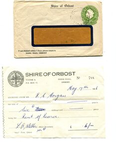
envelope and receipt, Snowy River Mail as "Mail" Print, May 17 1956
This receipt was issued to R. C. Morgan of Orbost. on May 17, 1956. It was for rent of reserve for six shillings. It was issued by the Orbost Shire Council. The Shire of Orbost was a local government area about 380 kilometres east of Melbourne, the state capital of Victoria, Australia. The shire covered an area of 9,347 square kilometres and existed from 1892 until 1994. Originally, Orbost was part of the Bairnsdale Road District which was created on 30 April 1867. Splitting away as part of the Shire of Tambo in 1882, Orbost was first incorporated as a shire in its own right as the Shire of Croajingolong on 30 May 1892. It received its present name on 17 February 1893. On 3 January 1913 part of its western riding was annexed to Tambo as its Cunninghame Riding. Local governments play an important role in the lives of citizens in Australia. Local government authorities exist to provide services and amenities to local communities, and are also responsible for regulating and providing services for land and property in their district. This item is representative of a time when Orbost had its own Shire Council. A widow - faced envelope with a green threepence stamp top right corner. At the top is "Shire of Orbost". Bottom right is "If not claimed within 7 Days please return to SHIRE HALL, ORBOST".There is a receipt to R.C. Morgan for 6/- being for the "rent of reserve" and signed by L.A. Walker. It has the Orbost Shire logo in the top left corner.orbost-shire-council morgan-r.c. -
 Ringwood and District Historical Society
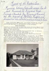
Memorabilia, Record of Historic Lane and formation of Carmel Haven Kindergarten, Ringwood East, Victoria - 1956
Buying of Carmel Haven and formation of kindergarten after Mrs. Olive Raftis and a committee bought the historic lane which ran between Victoria St. Lois St. and Wenwood St. Ringwood East.Six pages of memorabilia about the historic lane running between Victoria Street across Lois Street and Wenwood Street, Ringwood East formed by Ringwood Council at the request of Mrs. Olive Raftis and Committee who collected and subscribed to the lane, including picture of house bought to use as a Kindergarten. 26269-1. Description of location and photograph with summary of Kindergarten activities 26269-2. Newsletter - Second meeting of ratepayers to discus lane 26269-3. Receipt from Borough of Ringwood for supply of 400 square yards of concrete path Victoria Street to Wenwood Street to Mrs. Raftis 26269-4. Receipt to Committee for 18 yards of gravel for concrete gutter. 26269-5. Receipt to Mrs. O. Raftis £5 with 2d Victoria Stamp Duty attached. 26269-6. List of contributers. -
 Ringwood and District Historical Society
Plan, Ringwood Station Estate, Subdivision, Ringwood, Victoria - circa 1925
ID 5224 note: Further information relating to squares marked H, F, G, J, and K included in ID 5225 - Ringwood Shop and Dwelling Estate.Hand drawn plan of Ringwood Station Estate showing allotments for sale, with two typed pages attached showing land title information and sale prices.Drawn by Edyth Greenwood, phone 988 Central. Subdivision includes Station Street, Pitt Street, Bedford Road, Wantirna Road, James Street, William Street (later Kendall Street), Greenwood Avenue, Ellison Street, and Haig Street. Circles denote blocks for sale. Squares denote house properties for sale. Other features marked include location of businesses along Main Street (Maroondah Highway), cool store, railway station, shop and police station on Bedford Road, church on Station Street, site of schoolmaster's residence and State School, and location of proposed public baths. Ryner & Langford, Solicitors -
 Ringwood and District Historical Society
Letter, Property for sale - Ringwood Shop and Dwelling Estate, Ringwood, Victoria - circa 1925
ID 5225 note: Further information relating to allotments marked on the hand-drawn plan are included in ID 5224 - Ringwood Station Estate.Typewritten letter from A.V. Greenwood with hand drawn plan of Ringwood Shop and Dwelling Estate, detailed description of property for sale, and top and side elevation views of house. (7 pages)(Transcript of first page - to unknown recipient) Phone 988 Central, 331 Canty Greenwood Pty. Ltd. 5 Flinders Street Melbourne. Dear Sir, 1. Attached please find drawings of my house at Ringwood. 2. It is for sale at £4,865 or to let at £5 per week to an approved tenant. 3. I sold it to Mr. De Garis and vacated it, but it is now back on my hands. 4. I leased another place instead of living in my own. I may be able to cancel same; in the meantime, however, I propose to sell or let my own. The painters are now going through the place; re-varnishing, re-oiling and re-polishing so that in about five days it will look "spick and span". 5. The house was specially built under my own supervision. 6. It is very suitable for a high class Guest House, Doctor's residence, Hospital or Convalescent Home. If you know of anyone whom it might suit, please communicate with them. DESCRIPTION 7. It stands on 305 feet of land facing Greenwood Avenue. It is cement, roughcast and hardwood, well oiled, and is now being redone so that the house is as good as new; red tile roof; verandahs three sides; two sleep-outs; five bedrooms; large dining room; very large music room with nooks, upstairs lounge, study; sewing room; built-in wardrobes and cupboards throughout; handsome kitchen with handsome pantry cupboard with drawers and glass front; one bath room; one shower room; wash house with patent copper and laundry. Every modern convenience, hot water system (through copper pipes with large copper cylinder) electric lights everywhere, outside and in, Yan Yean water laid on everwhere throughout house and gardens. Floors throughout are the very best, close set, stained and polished; dainty lead light windows etc. 8. There is a big garage, with tiled roof and two rooms with all conveniences for a married couple. Property is well drained with a system of its own. The house stands upon the top of a hill close to Railway Station, say 500 feet from the Footbridge. 9. The garden has expansive shrubs; sheds; fernery; tennis court. 10. A handsome piece of furniture goes with the house; a combination pantry and storeroom for groceries, milk, bread etc., consisting of drawers, glass and wire doors, as mentioned above. 11. It is within easy distance of Melbourne as it is only two minutes from Ringwood Station, which is a frequent electric train service bringing it within 39 minutes of the City. It is thought better by some to go further out into the country atmosphere and walk a short distance at the end than to go by train 20 minutes then walk 15 to 20 minutes. 12. The price quoted of £4,865 is made up as follows - 305 feet of land @ £5 ... £1,515 Garage and dwelling ... £300 House hot water system, American cupboard ... £2,600 Water, fencing, sheds & drain ... £250 For the lot ... £4,865 Should you require copies of the enclosed drawings I shall be pleased to supply same. 13. Mr. J.B. McAlpin is the local agent, Phone Ring. 7 (after hours Ring. 44) or you may phone me Central 988. 14. The house is south of the line, facing Greenwood Avenue and immediately at the back of Ringwood House, which is also my property. Yours sincerely, A.V. Greenwood (illegible) ..... (Transcript of second page) RINGWOOD SHOP AND DWELLING ESTATE See these letters on plan attached (H.) Ringwood House and Shops on 100 by 150 feet of land fronting Bedford Road 100 feet @ £10 per foot - £1,000 House and shops - £2,400 ... £3,400 Ringwood House consists of Boarding House, (Phone 101) and two shops, mainly brick; 9 inch walls. Will carry another story. Has music room, dining room, entrance halls, 10 bedrooms, large verandahs, all conveniences, hot and cold water, and stands on what will become a most valuable business corner. (F.)(G.) Mr. Greenwood's house, garage and sheds, stands on 307 feet of land fronting Greenwood Avenue. See detailed description attached ... £4,865 (J.) Cottage on Block 81 in William Street ... £750 (K.) Cottage in Pitt Street ... £650 (Total) £9,665 ..... (Description of third page - Subdivision Plan) Drawn by Edyth Greenwood, phone 988 Central. Subdivision includes Station Street, Pitt Street, Bedford Road, Wantirna Road, James Street, William Street (later Kendall Street), Greenwood Avenue, Ellison Street, and Haig Street. Circles denote blocks for sale. Squares denote house properties for sale. Other features marked include location of businesses along Main Street (Maroondah Highway), cool store, railway station, shop and police station on Bedford Road, church on Station Street, site of schoolmaster's residence and State School, and location of proposed public baths -
 Ringwood and District Historical Society
Book - Business Records, Collection of 5 Day-books and Ledgers kept by Thomas Grant, Blacksmith, Ringwood, Victoria
GRANT, Thomas (From Short Notes on Ringwood - RDHS) Born 1854, died 1933, aged 79 years. Thomas Grant, born in Burwood, Victoria, came to Ringwood in 1876. On land purchased from Mr. D. Gostick in Whitehorse Road, in the vicinity of the present Drive In Arcade, he built a blacksmith's and coach building shop. In 1880, he married Mary Ann French, of Mulgrave. There were four children, Andrew, Mary, (died in infancy) Thomas, and Margaret. Miss Margaret Grant is a well known resident of Mullum Road. With the opening of the station in 1882, activities in the growing district tended to congregate in its vicinity, and, in 1883, Mr. Grant moved his “smith" to the corner of Adelaide Street. At the same time, he planted out an orchard on his land which ran from Ringwood Street, to Warrandyte Road, and north as far as Mullum Greek. Eventually, about 1910, he sold his business to the Reed Brothers, and retired to the comparatively lighter life of orchardist and market gardener. In 1909, he sold 8 acres of his land to the Lilydale Council. This land, situated in Ringwood Street, behind the Town Hall, is known as the Ringwood Reserve. Mr. & Mrs. Grant were foundation members of the Methodist Church. He was appointed a Trustee in 1879, and served until his death 54 years later. He was an enthusiastic member of many societies, and he held public office in civic affairs. His interests included the Progress Association, Cricket Club, and the Agricultural Society, at whose annual show, he was a regular exhibitor. He served as a Councillor in the Lilydale Shire, repres¬enting Ringwood, from 1889 to 1894, and was a Justice of the Peace. 26278a Ledger belonging to First Blacksmith in Ringwood 1880s. Dark green cover with leather spine and corners. Dark coloured edges on pages. 542 pages, 320 used. 26278b Day book belonging to Thomas Grant, Blacksmith, Ringwood used 1929. Brown covered book with leather spine. First 95 pages torn out. Only two pages of remaining 76 used. 26278c Ledger with alphabetical index - Thomas Grant, Blacksmith, Ringwood - 1888. Green covered book with red spine and corners. Dark coloured edges on pages. 275 pages. Some unused. 26278d T. Grant Blacksmith Day Book. Green covered day book of T. Grant, Blacksmith and General Smithy, Ringwood 1883 . Red square on spine with Day book written on it. Day Book in ink hand written on front spine. 26278e Day book belonging to Thomas Grant, Blacksmith, Ringwood - 1879-1881. Green cover with brown spine and edges. Gold lettering on spine saying Day Book Pages all used. 26278f Collection of receipts, some blotting paper, some pages from the Journal of Architecture, a short story, and drawing with description of an Albert Sociable carriage. -
 Orbost & District Historical Society
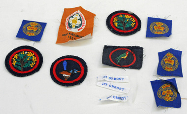
badges, 1950's -1960's
These badges are unused and were possibly available for those guides who took part in the various camps or became new members. they were designed to sew on to the guide uniforms or blankets. Nancye Wallace (nee Warren) was a Guide leader.Established in 1910, Girl Guiding is now one of the largest all female organisations in the world. It is designed for girls, young and not-so-young women to join and enjoy a program of informal learning, opportunities, fun, personal development and friendship. (ref. Girl Guides Victoria). These badges used by an Orbost local reflects the history of that organisation in Orbost.Twelve cloth badges. They are unused Girl Guide badges. two are round with a black background and inside a red circle is a wattle tree. One is round with a variegated fairy wren inside a red circle. One is rectangular with an eastern rosella inside a red circle. There are four smaller square shaped badges (cut from a strip) with gold, and red print on a blue background - " 1910 Girl Guides Jubilee 1960". One is a rectangular Camp Kindamindi badge and there are three rectangular strips, white with blue print "1st Orbost".badges-cloth girl-guides -
 Orbost & District Historical Society
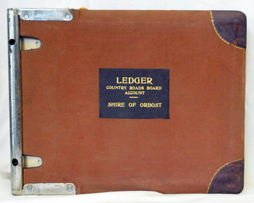
ledger, 1950's -1960's
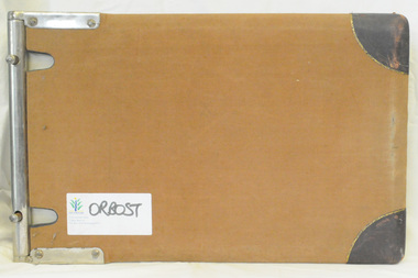
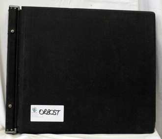
This ledger was used bt the Shire of Orbost local government to record Country Roads Board accounts 1950's and 1960's. The item was donated to Orbost & District Historical society from P.R.O.V. as a Place of Deposit (POD) item for safe keeping by a local history group or museum. The shire covered an area of 9,347 square kilometres and existed from 1892 until 1994 when it became part of the East Gippsland Shire Council. Orbost was at first included in the Bairnsdale Shire from 1882 and was later part of the Tambo Shire. Because of travelling distances the Croajingalong Shire was created in 1892 (name changed to Orbost Shire 17.2.1893 with James Cameron as the first Shire President. In 1994 it amalgamated to become part of East Gippsland Shire Council. The Country Roads Board was the government authority for the construction and maintenance of main roads in Victoria between 1913 and 1983. It was succeeded by the Road Construction authority on 1 July 1983 and later merged with the Road Traffic Authority on July 1 1989 to form the Roads Corporation. James Cameron, an Orbost farming pioneer and Member of the Legislative Assembly, fathered the Country Roads Board. This ledger is a hand-written record of accounts for the Orbost Shire local council. It pre-dates computer records. The Orbost Shire Council no longer exists having been absorbed into the East Gippsland Shire Council.A heavy brown coloured ledger with covered wooden covers. it has steel metal binding. Inside are strips of paper marking pages. It contains blue ink hand-written records of monies in/out (?) to Shire of Orbost Council. On the front cover inside a black rectangle in gold print is " LEDGER COUNTRY ROADS BOARD ACCOUNT ORBOST". It is an "Emu Binder".ledger orbost-shire accounts country-roads-board -
 Orbost & District Historical Society
ledger, 1950's ; 1960's
This ledger was used by the Shire of Orbost to record transactions with the Country Roads board in 1950's and 1960's. The item was donated to Orbost & District Historical society from P.R.O.V. as a Place of Deposit (POD) item for safe keeping by a local history group or museum. The shire covered an area of 9,347 square kilometres and existed from 1892 until 1994 when it became part of the East Gippsland Shire Council. Orbost was at first included in the Bairnsdale Shire from 1882 and was later part of the Tambo Shire. Because of travelling distances the Croajingalong Shire was created in 1892 (name changed to Orbost Shire 17.2.1893 with James Cameron as the first Shire President. In 1994 it amalgamated to become part of East Gippsland Shire Council. The Country Roads Board was the government authority for the construction and maintenance of main roads in Victoria between 1913 and 1983. It was succeeded by the Road Construction authority on 1 July 1983 and later merged with the Road Traffic Authority on July 1 1989 to form the Roads Corporation. James Cameron, an Orbost farming pioneer and Member of the Legislative Assembly, fathered the Country Roads Board. This item is a hand-written record of accounts of the Orbost Shire local Government. It pre-dates computer records,The Shire of Orbost Council no longer exists having been absorbed into th East Gippsland Shire council.A heavy brown coloured ledger with steel bindings. Covers are probably wooden. It contains hand-written records of transactions the Country Roads Board. -
 Orbost & District Historical Society
ledger, late 1950's - 1970's
This ledger was used by the Shire of Orbost in the late 1950's - 1970's.The item was donated to Orbost & District Historical society from P.R.O.V. as a Place of Deposit (POD) item for safe keeping by a local history group or museum. The shire covered an area of 9,347 square kilometres and existed from 1892 until 1994 when it became part of the East Gippsland Shire Council. Orbost was at first included in the Bairnsdale Shire from 1882 and was later part of the Tambo Shire. Because of travelling distances the Croajingalong Shire was created in 1892 (name changed to Orbost Shire 17.2.1893 with James Cameron as the first Shire President. In 1994 it amalgamated to become part of East Gippsland Shire Council. The Country Roads Board was the government authority for the construction and maintenance of main roads in Victoria between 1913 and 1983. It was succeeded by the Road Construction authority on 1 July 1983 and later merged with the Road Traffic Authority on July 1 1989 to form the Roads Corporation. James Cameron, an Orbost farming pioneer and Member of the Legislative Assembly, fathered the Country Roads Board This item is a hand-written record of Orbost Shire Council accounts. It pre- dates computer records. The Shire of Orbost local council no longer exists having been absorbed by the East Gippsland Shire Council.A black ledger with wooden covers. It contains hand-written records of transactions between Orbost Shire Council and the Country Roads Board.bottom left corner - Orbost in black on a white East Gippsland Shire logoledger accounts shire-of-orbost country-roads-board -
 Cheese World Museum
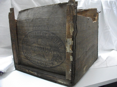
Box, butter
This butter box belonged to Jack Gore of Warrnambool who used it in his garage to store car parts. It is connected to Warrnambool Cheese and Butter Factory Company Limited through the box manufacturer, Peter John McGennan, who was one of the instigators of the factory. Cobden and Warrnambool factories were the first two co-operative factories to produce butter in Victoria, both commencing in 1888. Warrnambool Cheese and Butter Factory Company Ltd is the only remaining independent butter factory still using its original name. It is an example of the manner in which butter was packed for export from the late 19th century until well into the 20th century. Its innovative design is light but strong, using plywood for the box body and struts 'stitched' to the body with wire. The ply was originally pine imported from New Zealand which did not taint the butter. Following the exclusion of the timber from NZ, plantations of local pine were planted and used. McGennan's box factory supplied butter boxes to the majority of butter factories in Victoria, producing up to half a million boxes per year by 1917.This Cobden butter box is historically significant relating to the butter industry and a rare item. Not many of these exist. Wooden butter box with broken ends and a hole in the bottom.Constructed using thin ply ends, sides and base with square wooden struts tied with wire to strengthen the box. The trade mark on the end of the box is an oval with text around a map of Australia with the word AUSTRALIA printing across the map.COBDEN/PURE CREAMERY BUTTER/56lb Net/VICTORIA/REGD No.528butter, dairying, dairy manufacturing industry, butter boxes, cobden -
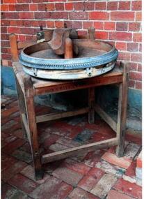 Learmonth and District Historical Society Inc.
Butter Churn, Circa late 1800's
Very little is known about this particular Butter Churn. It may have been used by a local dairy farmer.an example of early butter churns (wooden) used around the late 1800's by dairy farmers.A large round wheel made of wood with an iron rim and a wooden paddle turned by a handle.It is on a square wooden stand.Cherry and Sons.Gisborne Victoria1800'sbutter churn.food preparation -
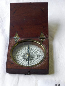 Flagstaff Hill Maritime Museum and Village
Instrument - Compass, c. 1839
This magnetic compass is a good size to fit easily into a person's pocket or personal luggage and is protected from knocks by its wooden case. It could have been used for reference when travelling on land or sea. There is no visible manufacturer's mark, which may mean that it was not of high monetary value. Leith is a district of Edinburgh in the country of Scotland, the U.K. It was once the Port of Edinburgh and many migrant ships departed from here bound for the Australian colony. It had a busy shipbuilding industry, with wet and dry docks. It appears from the inscription on the case "Chas Gray, LEITH, 1839" that this pocket compass once belonged to Charles M. Gray (Chas is a common abbreviation for the name Charles). The inscription coincides with the name, place and date that the Western Victorian pioneer Charles M. Gray left Scotland and arrived in Australia. Charles Gray was born in Anstruther, Scotland, in 1818. His family was connected with the Royal Marines, which may have created his nautical instruments such as this pocket compass. Charles Gray arrived in Hobson's Bay on 15 June 1839 on the ship “Midlothian”. That same ship had departed from Leith, Scotland on February 15th 1839. Did Charles Gray acquire the pocket compass in Leith, perhaps as a gift or a souvenir of his motherland? Charles Gray was an early squatter and went on to become a very successful settler as a sheep pastoralist in the Western District of what is now Victoria (originally the colony of New South Wales). He and his wife had a large property called “Nareeb Nareeb”, Green Hill Creek District (now Glenthompson), Victoria, from 1840-1886. He was also a local Councillor and Justice of the Peace, and had an interest in the local indigenous people; he named his property after their tribe. Charles returned to England in 1890 and died there in 1905. Charles Gray had written an account in 1890 of his life at Nareeb Nareeb, called Western Victoria in the Forties: "REMINISCENCES OF A PIONEER The Western District in the 1840's By Charles Gray" , a valuable historical reference to colonial Victoria. His book was published by the Hamilton Spectator in 1932. Charles Gray's photograph is one of 713 historical photographs of early Victorian settlers, created as a montage by Thomas Foster Chuck in 1872. The State Library of Victoria holds the framed montage titled “The Explorers and Early Colonists of Victoria”. To qualify for inclusion on this montage the Settlers must have arrived in Victoria before 1843. Charles Gray's photograph is number 349! The pocket compass is associated with Charles Gray, one of the early squatters and settlers in Western Victoria, possibly given to him as a parting gift on his emigration to Van Diemans land in 1839. The item is very significant as it's connection with one of Victoria's early pioneers is well provenanced by the inscriptions on the wooden case. Pocket compass, brass, set into a square wooden case with hinged lid and small hook catch. Compass is marked with 360 degrees and compass points and has two pointers; one to show magnetic north and one to set the direction of travel. Hinges are triangular and inset into the wood. The lid has an attached brass plaque with the inscription "Chas Gray, Leith, 1839" (It likely belonged to Charles Gray, Leith, UK, who migrated to Port Philip Australia in 1839 and became a successful pastoralist.) “Chas Gray / LEITH / 1839” engraved on brass plaque on lid.flagstaff hill, warrnambool, shipwrecked coast, flagstaff hill maritime museum, maritime museum, shipwreck coast, flagstaff hill maritime village, great ocean road, magnetic compass, pocket compass, charles m. gray, chas gray, migrrant from leith 1839, charles gray anstruther, scottland, ship midlothian 1839, squatter western victoria, settler western victoria, hobson's bay port phillip australia, charles gray nareeb nareeb - green hill creek district, western victoria in the forties: reminiscences of a pioneer by charles m. gray 1890, leith edinburgh u.k., western victoria in the forties: reminiscences of a pioneer - montage by thomas foster chuck 1872, charles gray, reminiscences of a pioneer, the western district in the 1840's, compass, scientific instrument, nautical instrument, direction, directional compass, navigation -
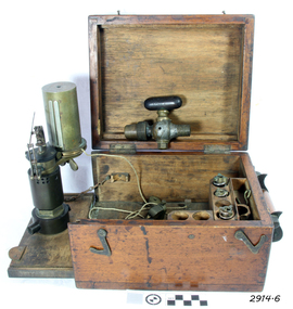 Flagstaff Hill Maritime Museum and Village
Engine Dynamometer, c.1890’s
The steam engine indicator, or dynamometer, is an instrument used on a steam engine (such as that of a vessel or train) to measure and record the change in the pressures of the engine’s cylinders during their operating cycle. The engineer would use it to identify problems or defects such as bad valve settings or constricted steam pipes. It could indicate the difference in efficiency caused by adjustments made to the engine, being able to instantly measure the variation of pressure from the engine stroke at any given time. This force of power would be registered by a pencil, fitted to the adjustable arm, which would trace a line on paper wound around the cylinder. The recorded information could be used in conjunction with mathematical tables. This particular instrument was made by T.S. Mc Innes, one of the better manufacturers of engine indicators. Mc Innes engine indicators were still being used in the mid 1900’s. This specific instrument was used by Mark Forsythe of North Berwial, Scotland and late of Ararat, Victoria when he was chief engineer on the “SS Talawena” in 1892. The Port of Warrnambool, in Victoria, harboured steam ships that carried both passengers and cargo along the south west coast in the late 1800’s and into the 1900’s. The engineer of a steam ship was responsible for reaching and maintaining the optimum level of steam energy to serve the locomotion and efficiency of the steam ship. The engineer would use a steam engine indicator to measure and record information to achieve this purpose. Engine Dynamometer or Steam Engine Indicator in square, fitted oak case. This brass instrument is used to measure and record steam pressure for setting up and adjusting valves on a steam engine. It has an oscillating recording drum with vertical, silver clip attached for holding paper in place around the drum. The drum oscillates left to right. There is a pulley attached to a length of cord, which is attached to the drum. Beside the drum is a fine metal arm, vertically adjustable, small hole in the end to hold a pencil. Inscription stamped into bracket of the arm. The engine indicator is mounted on a hinged side of the case that swings out ready for use. Attached chains prevent the side from opening past vertical. There is storage for other accessories and an empty compartment in the base (where a scale or ruler may have been located). The case has a collapsible wooden handle, brass hinges and two brass, hook-shaped catches. There is a code stamped inside the lid. It contains a brass, ‘T’ shaped steam-cock (or stop cock) with two open ends made of metal pipe with different sized threads. (Turning the handle on top opens and closes the space in the pipe and would close off the flow of steam from one end to the other.) Also inside the case are three different spiral springs, each with a threaded nut on the end that has a threaded hole inside it. Used by Mr Mark Forsythe when chief engineer on the SS Talawena in 1892 “T.S. MC INNES PATENT” and “522 _ _” (last 2 digits are unreadable) pressed into the arm of the brass indicator. “[ ] X ’ stamped inside the lid of the case. The 3 springs all have a number stamped into them: (1) “32” and “12” (2) “12” and “16” [above] “12” (3) “64” and “150” Card that came with instrument “This instrument was used by Mark Forsythe of North Berwial Scotland and late of Ararat, Victoria when chief engineer on the SS Talawena in 1892" dynamometer, steam engine indicator, t.s. mcinnes, glasgow, dobbie mcinnes, port of warrnambool, warrnambool, flagstaff hill, flagstaff hill maritime museum, flagstaff hill maritime village, maritime museum, shipwreck coast, great ocean road -
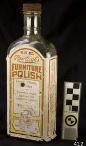 Flagstaff Hill Maritime Museum and Village
Container - Glass Bottle, W T Rawleigh, 1920s
W.T. Rawleigh's & Co. manufactured various household products in a factory in Collins Place, Melbourne, between 1930 and 1935. The W.T. Rawleigh Company was an American company started by William Rawleigh in 1889. The company expanded to both Canada and Australia with the Rawleigh company specialising in medicines, remedies, food additives, cleaning products and toiletries. Due to increased demand, Rawleigh’s required a larger factory and thus built the factory in Dawson Street Brunswick Victoria and by 1950 the factory had been extended to include 98,000 square feet of floor space. The Brunswick factory ceased production in the late 1970s and manufacturing was moved to New South Wales. During the peak of production, more than 200 people were employed in the Brunswick factory and several independent sale representatives sold their products door-to-door throughout the country. The ‘Rawleigh’s man’ was a regular door-to-door salesman of inter war and post-war suburban Melbourne. Rawleigh’s products are still in production today.A significant item as it gives a snapshot into domestic life and social norms of the pre and post war period in Melbourne and throughout Australia and New Zealand. The item demonstrates how selling house hold products door to door was pioneered in Australia by the Rawleigh’s company in the early 1900s and is still in existence today.Bottle, glass, narrow neck rectangular base with metal screw top.label of Rawleigh's Furniture Polishflagstaff hill, warrnambool, flagstaff hill maritime museum, shipwreck coast, flagstaff hill maritime village, great ocean road, bottle, rawleigh's furniture polish, furniture polish, rawleigh's, cleaning