Showing 2441 items matching "early development"
-
 Kiewa Valley Historical Society
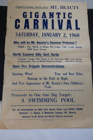
Poster - Mt Beauty Gigantic Carnival, 1960
The residents of Mt Beauty and the Kiewa Valley swam in the local East and West Kiewa Rivers. The community began planning the building of a swimming pool at Mt Beauty in the early 1960s and held events to raise money for it. The building of a swimming pool in Mt Beauty is part of the construction town's development and demonstrates the support of the community, especially the Mt Beauty and District Progress Association, and the SECV.Yellowed paper with black print dated Saturday, January 2, 1960 advertising the events for the day at Mt Beauty. Proceeds to the Swimming Pool.mt beauty swimming pool, carnival, mt beauty and district progress association -
 Kiewa Valley Historical Society
Wheelchair
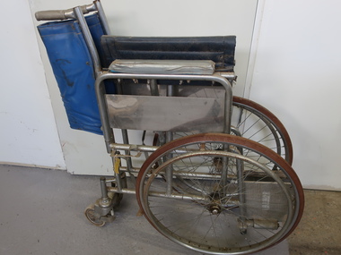
After WWII demand for wheelchairs increased. The original wheelchairs were driven by the patient's hands pushing the wheels. Later a motor was added. Then the motor and battery were built into the chair under the seat. This was followed by developments in ergonomics (comfort), controls, comfort and performance.See KVHS 1796, KVHS 1797Used by Wilma Davies, a Kiewa Valley resident, who suffered from polio from the early 1950s.2 large wheels - The outer wheel is steel and the inner is rubber with metal spokes attached. The foot plates are of ribbed steel. The ribbed seat is blue made of thick canvas as is the back of the chair. Some plastic has been glued on the back. The arm rests are also covered with old torn plastic. There is a metal stick on the side used to brake the chair by being pulled enabling it to touch the wheel and slow it down or stop it from turning."Sibbing / Melbourne" on the foot platespolio, wheelchair, pandemic -
 Kiewa Valley Historical Society
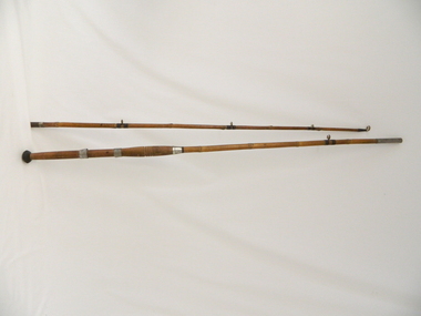
Rod Fishing, circa early 1900's
This bamboo fishing rod was used in the mid to late 1900's and demonstrates that local production of recreational fishing poles was at a high level and their demand was high. Imported recreational sporting goods from either the United Kingdom, the United States of America or Asia countries was due to the larger lead up times from these suppliers and the greater import costs from slower ocean supply ships. It was only after World War II that the trade influx from other countries has supplied cheaper goods. This recreational fishing pole is highly significant to the Kiewa Valley as it demonstrates that recreational fishing has been evolved from the need to supply a balanced diet by the early pioneer families of fish from the major Kiewa rivers. The ability of the Kiewa Valley rivers to provide a good fishing environment (high protein diet) for both early indigenous families and early pioneers was the important food source that provided for a balanced diet and the higher level of nutritious development of both body and mind. This two piece wooden fishing Rod is made from bamboo shafts or poles, one length thicker than the other. The smaller diameter shaft is the top end and fits into the longer thicker shaft at a stainless steel tube end.The smaller shaft has a stainless steel reinforcement ring where both shafts fit together. At the bottom end of the thick shaft is a black rubber "stopper" or "foot". There are two stainless steel rings, each with a reel holding "bulge" which allows for the the reel's "prongs" to be secured. The top ring has a greater diameter allowing it to move up and down the shaft/pole to secure the top "prong" firmly onto the shaft/pole.recreation, river, rod, fishing, industry, fish -
 Kiewa Valley Historical Society
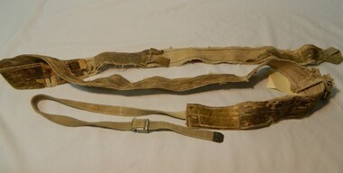
Seal Skins Ski Straps / Soles, mid 1900's
These seal skin straps and webbing were introduced into the Victorian Alps by European engineers, conducting survey work for the SEC Hydro scheme in the late 1930s. This period in time produced many immigrants from a war torn Europe with highly developed technical skills. Many of these immigrants provided articles that were well suited to the alpine regions of Australia, ones they used in their homelands. These were times when the home grown cultures of the Anglo Saxon heritage of the earlier settlers within the Kiewa Valley became interwoven with the various European cultures and this formed, what in later years became the beginning of the Australian multi-cultural society. The Kiewa Valley and its surrounding regions where the major rural areas which did not progress in a so typical Aussie "dinky-di", "she'll be right" fashion. The European influence was however not too strong, so as to obliterate the flavour of the home grown rural society.The major populated sections of the upper Kiewa Valley and the Alpine regions were accelerated by the SEC Hydro Development which brought into the slow growing rural regions a quasi multi ethnic society, however this was only noticeable up to the time when the final Power Station was commissioned in the 1960s. The slight variations to the typical Australian rural settlements of the time were in some food preparations, winter apparel such as these seal skin straps and soles and "langlauf" (cross-country skis). The sealskins were sewn so that their grain ran from front to back thereby allowing the skins to grip going up hill and glide going downhill.The gardens and varieties of flowering shrubs and trees where also more in line with traditional European "outdoor" settings. Seal skin sewn onto one side of a strap of webbing. There is a webbing loop on the front that slips over a small point at the front of the ski. There is a webbing strap attached to the back of the seal skin sole coming over the back of ski that clips metal fasteners onto a loop of webbing behind the ski boot. alpine sports, snow skis, winter clothing, mount bogong recreational activities, snow sports -
 Kiewa Valley Historical Society
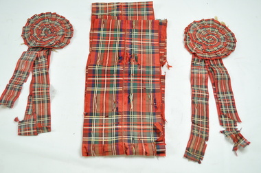
Sash and Rosettes Tartan
Early athletics year 11 school championships Kiewa Valley School Carnival circa 1920 - 1950s Historical and social significance of school based physical development of children through dedicated sports programs. An integral part of child development and socialising within the formal school environmentSash made from fine cotton weave with Scottish highland tartan. Width 12cm and sides fine stitched. Pattern (Royal Stewart) running length of ribbon.Two rosettes of same material 9cm diameter with three 3cm wide ribbons attached lengths 16cm, 20.5cm and 28cm The "Glen" designHighland clan to be identified sash, rosettes, school foot races -
 Kiewa Valley Historical Society
Book - Reference S.E.C. History x4, Brown Power A Jubilee History of the State Electricity Commission of Victoria, first published 1969
Although this book revolves around the supply of power(Electricity) from brown coal it does cover the period 1937 onwards when the Kiewa Hydro Electricity Scheme was first mooted. This area was believed to be far away from aerial bombardment should the coastal power stations be attacked by air in World War II(1939 -1945). After the war, post 1945, the demand for a continual power supply, not affected by seasonal coastal flooding was together with a lower cost of hydro electricity power the major incentive for the Victoria Government of the day to proceed (in the 1940s) with The Kiewa Hydro Electricity Scheme. In 1946 Victorian government sought greater independence from the New South Wales black coal supplies.The significance of this book to the Kiewa Valley and its outlying regions is that it details why the development of an Alpine region was and now still is pocketed with a European flavour both in buildings and in town vegetation(trees and flowers). European (post World War II refugees) where attracted to these alpine areas not only for hard labouring positions but also for their technical skills and some street names offer a distinct European lineage rather than convict or of earlier English settler. The construction phase accommodation continued after completion of the Kiewa Hydro Electricity Scheme to become popular venues for an increasing winter tourism industry. This book has a brown hard cover encapsulated by a cream sleeve with brown and black print. On the front of the sleeve is an embossed circular motif with centre piece S.E.C. emblem and around this the words "50 YEARS OF SERVICE" and below this" STATE ELECTRICITY COMMISSION OF VICTORIA". The book contains 313 double sided pages of black print and black and white photographs.On front of paper sleeve "Brown Power A Jubilee History of the State Electricity Commission of Victoria Cecil Edwards". On the second page, below the Title "Brown Power" there is a pasted, printed presentation certificate, with the S.E.C. emblem and these printed words " Presented by the Chairman and Commissioners to A.G. MILLIST, ESQ. in recognition of long and valued service with the Commission"electricity, victorian power supplies, hydro electricity, brown coal, cecil edwards -
 Kiewa Valley Historical Society
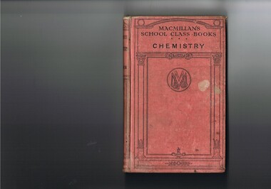
Book - Reference Chemistry, Elements of Chemistry, first printed 1887 this item 1921
This item is a good example of a pre 1960's school science reference books. It contains sketches of experimental apparatus and not colored photographs of later text books. Although the sketches are very instructional they do not show the various colours obtained when mixing some compounds. The history of reprints demonstrates the quality of the information and the ease of study for students using this book. The era of this publication was a time when sources for knowledge in schools was restricted to mainly school books and teacher demonstrations. The student in the 2 Millennium has a far greater reference source available e.g. the internet. This book is significant to the Kiewa Valley as the Davies family (Tas Davies, penned on the first page), belong to the early settlers of the valley. The book acknowledges that although the region was relatively isolated up to the mid 1900s, the good teaching methods of local schools did not suffer in this rural area. This region was not in the backwaters of scholarly development and modern progressive thought. As with "school of the air" distances in rural areas, between centres of learning and recipients, became irrelevant provided that the social stimulant to learn exists. The "local school" mind set within rural areas was, even before the improvement of the communication "explosion" of the early 1900s followed by the internet facilities of the late 1900s, the greatest drive in cutting the anomalies between city and rural learning facilities. Government decentralising higher education facilities into regional centres (Wodonga - Albury) provided greater access for the learned mind.This item (book) has a faded red colour, hard cover with black print and rectangular design. Within this design is an encircled double "M" and "&" (in the left inverted V of the M) and a "Co" (in the right inverted V of the M). On the front cover "MACMILLAN'S SCHOOL CLASS BOOKS CHEMISTRY" and on the spine "ELEMENTS OF CHEMISTRY" underneath "REMSEN" and at the bottom"MACMILLAN & Co"school, chemistry, text books, science experiments -
 Kiewa Valley Historical Society
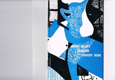
Book - Reference Cooking, Mount Beauty Souvenir Cookery Book x2, Circa 1962
This cookery book was printed in the early 1960s for the purpose of obtaining the necessary funds for the construction of the Mount Beauty swimming pool. The advertisements within this book covers local traders of this time frame, for example, the Bogong Hotel which is no longer operational. the culinary measurements are in Imperial measures(pounds and ounces). The book has sections for continental dishes and sweets (Australian flavour), special dishes for Lent, cakes (farmhouse fruit cake), jams, marmalades (home made), marrow and apple chutney. Some of these recipes are early 20th Century related and in the 2000s are not sought after. The food "take away" lifestyle has been responsible for the demise of a lot of the recipes in this book. The swing away from home grown produce has been not only a lifestyle change but also the faster pace of living in rural areas. The specialisation and redefined development of the local produce store (previously provided everything the rural shopper needed) was a forced move due to larger and cheaper city born fresh food supermarkets. Although there are still some local produce store within the region these will in time vanish. This cookery book was produced just after Mount Beauty was released from an SEC "closed" community in 1961(see KVHS 0134) and the town then had to fend for itself. This book was compiled and produced because the town needed a swimming pool (which possible would have been provided had the SEC still been responsible). The book demonstrates the strong rural psyche of rallying together for the good of all and united for something which would be of benefit to all. The period 1961 to the 1970s was one of great change for Mount Beauty. The SEC protective cage was a blessing for some but a goal for others. The independence that was gained after the SEC left provided for a drastic "make over" in regards to the facilities provided for the "locals" and that for the tourists. An increase in tourist related industries such as snow skiing in winter, hang gliding and gliding, mountain bike rallies, bush walking and horse riding, all of which have supply outlets in the town, has provided a more cosmopolitan atmosphere. These activities and the greater interaction with populations outside of the region has reduced the "hermit" type feel of the town psyche.This recipe book consists of eighty nine pages in black and white print. It contains black and white sketches, recipes of local domestic cooks and advertisements covering local traders. The cover is approximately 280 g/m2 in weight and the pages are at 90 g/m2 in weight. The cover has a design in the style of Abstract Expressionism (period 1950-1960s) of identifiable (clock,jug,fruit,window) and abstract objects in tints of blue and shades of black. This was designed by Cheryl Ryder of the Mount Beauty High School, under supervision of Mr I Baker (Art Teacher)On the foreword(page two and page three) "Mt. Beauty Souvenir Cookery Book First Edition" . This foreword was presented by Rosa Kinnear, President, Ladies' Auxiliary 2nd copy - no inscriptionrecipe, cooking, food, domestic, kitchen, local history, comfort food, pioneer cleaning methods -
 Eltham District Historical Society Inc
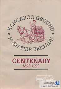
Book, Bruce Bence, Kangaroo Ground Bush Fire Brigade, centenary 1892-1992 : the story of the Kangaroo Ground Fire Brigade / Bruce Bence, 1992
Contents (described as Index): The early days, Ewen Hugh Cameron, 1914-1939, Supporting organisations, Eltham Emergency Operations Centre, Kangaroo Ground Fire Brigade Ladies Auxiliary, The fire tower, the Salvation Army and Red Cross, 1930-1992, The Kangaroo Ground Fire Brigade Today, Kangaroo Ground Fire Brigade Chronology. Includes a list of names of office bearers. Also includes references to neighbouring brigades and copies of historical newspaper articles. This publication was supported by the resources, information and facilities of The Shire of Eltham Historical Society.This book is significant in that not only does it traces the development of Kangaroo Ground Bush fire brigade since 1892 and of emergency services in the area but it also gives an insight into the people and their community.Softcover; 61 p., [7] p. of plates : b&w ill., 7 maps, ports.ISBN 064606651Xkangaroo ground, fire brigades, emeregency services, kangaroo ground fire brigade, fires, bush fires, shire of eltham war memorial, kangaroo ground tower -
 Eltham District Historical Society Inc
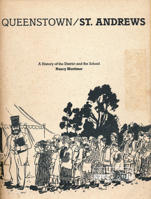
Book, Queenstown / St Andrews: A history of the district and the school by Nancy Mortimer, 1983
Local history book published on the occasion of the 125th anniversary of St Andrews Primary School 1983. Contents: Forward, Headmaster's message, early days at St. Andrews, School No 128: St Andrews, Why should children practice temperance, 3594 Queenstown North, 933 Smith's Gully, 1737 Smith's Gully, The Church of St Andrews, Post Office, St Andrew's Hotel. Includes some photos and illustrations including reproduced original documents. Includes list of head teachers 1858-1983. Includes names of pupils 1983.This book is significant in that not only does it traces the development of St Andrews Primary School and of education in the area but it also gives an insight into the people and their community.Softcover, 109 pagesqueenstown, st andrews, education, st andrews primary school -
 Eltham District Historical Society Inc
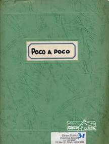
Book, Poco a Poco: the story of the Shire of Eltham Brass Band, November 1964, 1964
Page [i] : Prepared for the Committee of the Shire of Eltham Brass band by E. Y. Barnes. This may have been an early draft copy as it includes pen notations and corrections. Page 2: "The aim of this presentation is to give a balanced comprehensive story of the Shire of Eltham Brass Band, its origins, aims, history and operations". The Band was formed in 1954 with male members, Includes a list and biographies of bandmasters, uniforms, engagements, names of and roles of "helpers" and names of organisations which the Band has been associated. as well as names of early band members and other associated members. This document is significant in that it not only traces the development of the Shire of Eltham Brass Band (a forerunner of the current Eltham Concert Band) and of music in the area but it also gives an insight into the people and their community in the 1950s and early 1960s.Original typed manuscript with occasional photocopied sketch enclosed in a green folder. Calligraphy on cover plate and title page Title pages includes the signature: E.Y. Barnesbrass band -
 Eltham District Historical Society Inc
Ledger, Eltham Road District. Assessment for the Year ending Oct. 14th, 1858, 1857c
The Eltham Roads Board was established in 1856. This is a unique significant record of early settlers in the Shire of Eltham. One of 6 early rate books. This is among the oldest items in the EDHS collection. An article in the Eltham and Whittlesea Shires Advertiser Friday 21 Nov 1941 Page 5 titled: District's Early History states: "The first rate book which is still in existence at the Shire Office is for the year ending October 14, 1858 and is probably the best record possible to indicate the development of the district. At the time properties were rated as follows: Cultivated land. 6d. per acre; pasture land, 1d. per acre: estimated annual value of buildings, etc., 6d in the (pound). The total amount of rate recorded for the year was (pounds)153/14/8. Properties were described as being situated at Lower Plenty, Yarra Yarra, Eltham, Lower Eltham, Kangaroo Ground, Yarra Flats, Diamond Creek and the Yarra."Ledger with printed columns: Number, Name of Occupier, Description, Where situated, Cultivated land, Pasture land, Estimated annual value of buildings, Rate, Remarks. Ledger filled out by hand with 152 entries (not alphabetically arranged). A number of blank pages are included. Copy re-bound in green hard leather look card by Arnall & Jackson Pty Ltd Brunswick, 1968 Inside cover includes a compliments slip taped to the cover from Arnall & Jackson Pty Ltd. with handwritten inscription: "Ian, I hope the hysterical society doesn't get historical about this". Organised 1968 I. Maynard Inside cover includes pasted printed note: RATE OF ASSESSMENT AS FOLLOWS: Cultivated land 6d per acre Pasture land 1 per acre Estimated Annual Value of Buildings, &c., 6d. in the Pound eltham roads board, rate book, rate payers, transaction, pioneers, settlers, 1858, assessment ledger, eltham road district, public records office victoria (prov), rate books, shire of eltham archives -
 Eltham District Historical Society Inc
Ledger, Eltham Road District. Assessment for the Year ending Oct. 14th, 1859, 1858c
The Eltham Roads Board was established in 1856. This ledger includes the signature of Road Board Secretary and Collector Wingrove, a significant person in Eltham's early history. This is a unique significant record of early settlers in the Shire of Eltham. One of 6 early rate books. This is among the oldest items in the EDHS collection. An article in the Eltham and Whittlesea Shires Advertiser Friday 21 Nov 1941 Page 5 titled: District's Early History states: "The first rate book which is still in existence at the Shire Office is for the year ending October 14, 1858 and is probably the best record possible to indicate the development of the district. At the time properties were rated as follows: Cultivated land. 6d. per acre; pasture land, 1d. per acre: estimated annual value of buildings, etc., 6d in the (pound). The total amount of rate recorded for the year was (pounds)153/14/8. Properties were described as being situated at Lower Plenty, Yarra Yarra, Eltham, Lower Eltham, Kangaroo Ground, Yarra Flats, Diamond Creek and the Yarra."Ledger with printed columns: Number, Name of Occupier, Description, Where situated, Cultivated land, Pasture land, Estimated annual value of buildings, Rate, Remarks, Arrears collected, excused, unoccupied, uncollected and amount actually collected. Ledger filled out by hand with 173 entries (not alphabetically arranged). A number of blank pages are included. Inside cover includes pasted printed note: RATE OF ASSESSMENT AS FOLLOWS: Cultivated land 6d per acre Pasture land 2d per acre Unalienated Pasture Land 8d per Acre Estimated Annual Value of Buildings, &c., 6d. in the Pound eltham roads board, rate book, rate payers, transaction, pioneers, settlers, wingrove, 1859, assessment ledger, eltham road district, public records office victoria (prov), rate books, shire of eltham archives -
 Eltham District Historical Society Inc
Ledger, Eltham Road District. Assessment for the Year ending Oct. 14th, 1860 (Version 1), 1859c
The Eltham Roads Board was established in 1856. This is a unique significant record of early settlers in the Shire of Eltham. One of 6 early rate books. This is among the oldest items in the EDHS collection. An article in the Eltham and Whittlesea Shires Advertiser Friday 21 Nov 1941 Page 5 titled: District's Early History states: "The first rate book which is still in existence at the Shire Office is for the year ending October 14, 1858 and is probably the best record possible to indicate the development of the district. At the time properties were rated as follows: Cultivated land. 6d. per acre; pasture land, 1d. per acre: estimated annual value of buildings, etc., 6d in the (pound). The total amount of rate recorded for the year was (pounds)153/14/8. Properties were described as being situated at Lower Plenty, Yarra Yarra, Eltham, Lower Eltham, Kangaroo Ground, Yarra Flats, Diamond Creek and the Yarra."Ledger with printed columns: Number, Name of Occupier, Description, Where situated, Cultivated land, Pasture land, Estimated annual value of buildings, Rate, Remarks, Arrears collected, excused, unoccupied, uncollected and amount actually collected. Ledger filled out by hand with 177 entries (not alphabetically arranged). A number of blank pages are included. Inside cover includes pasted printed note: RATE OF ASSESSMENT AS FOLLOWS: Cultivated land 6d per acre Pasture land 2d per acre Unalienated Pasture Land 8d per Acre Estimated Annual Value of Buildings, &c., 6d. in the Pound eltham roads board, rate book, rate payers, transaction, pioneers, settlers, wingrove, 1860, assessment ledger, eltham road district, public records office victoria (prov), rate books, shire of eltham archives -
 Eltham District Historical Society Inc
Ledger, Eltham Road District. Assessment for the Year ending Oct. 14th, 1860 (Version 2), 1859c
The Eltham Roads Board was established in 1856. This is a unique significant record of early settlers in the Shire of Eltham. One of 6 early rate books. This is among the oldest items in the EDHS collection. An article in the Eltham and Whittlesea Shires Advertiser Friday 21 Nov 1941 Page 5 titled: District's Early History states: "The first rate book which is still in existence at the Shire Office is for the year ending October 14, 1858 and is probably the best record possible to indicate the development of the district. At the time properties were rated as follows: Cultivated land. 6d. per acre; pasture land, 1d. per acre: estimated annual value of buildings, etc., 6d in the (pound). The total amount of rate recorded for the year was (pounds)153/14/8. Properties were described as being situated at Lower Plenty, Yarra Yarra, Eltham, Lower Eltham, Kangaroo Ground, Yarra Flats, Diamond Creek and the Yarra."Ledger with printed columns: Number, Name of Occupier, Description, Where situated, Cultivated land, Pasture land, Estimated annual value of buildings, Rate, Remarks, Arrears collected, excused, unoccupied, uncollected and amount actually collected. Ledger filled out by hand with 177 entries (not alphabetically arranged). A number of blank pages are included. This version was slight changes to version one. Inside cover includes pasted printed note: RATE OF ASSESSMENT AS FOLLOWS: Cultivated land 6d per acre Pasture land 2d per acre Unalienated Pasture Land 8d per Acre Estimated Annual Value of Buildings, &c., 6d. in the Pound eltham roads board, rate book, rate payers, transaction, pioneers, settlers, 1860, assessment ledger, eltham road district, public records office victoria (prov), rate books, shire of eltham archives -
 Eltham District Historical Society Inc
Ledger, Eltham Road District. Assessment for the Year ending Oct. 14th, 1861, 1860c
The Eltham Roads Board was established in 1856. This is a unique significant record of early settlers in the Shire of Eltham. One of 6 early rate books. This is among the oldest items in the EDHS collection. An article in the Eltham and Whittlesea Shires Advertiser Friday 21 Nov 1941 Page 5 titled: District's Early History states: "The first rate book which is still in existence at the Shire Office is for the year ending October 14, 1858 and is probably the best record possible to indicate the development of the district. At the time properties were rated as follows: Cultivated land. 6d. per acre; pasture land, 1d. per acre: estimated annual value of buildings, etc., 6d in the (pound). The total amount of rate recorded for the year was (pounds)153/14/8. Properties were described as being situated at Lower Plenty, Yarra Yarra, Eltham, Lower Eltham, Kangaroo Ground, Yarra Flats, Diamond Creek and the Yarra."Ledger with printed columns: Number, Name of Occupier, Description, Where situated, Cultivated land, Pasture land, Estimated annual value of buildings, Rate, Remarks, Arrears collected, excused, unoccupied, uncollected and amount actually collected. Ledger filled out by hand with 185 entries (not alphabetically arranged) and summary section. A number of blank pages are included. Inside cover includes pasted printed note: RATE OF ASSESSMENT AS FOLLOWS: Cultivated land 6d per acre Pasture land 2d per acre Unalienated Pasture Land 8d per Acre Estimated Annual Value of Buildings, &c., 6d. in the Pound eltham roads board, rate book, rate payers, transaction, pioneers, settlers, 1861, assessment ledger, eltham road district, public records office victoria (prov), rate books, shire of eltham archives -
 Eltham District Historical Society Inc
Ledger, Eltham Road District. Assessment for the Year ending Oct. 14th, 1862, 1861c
The Eltham Roads Board was established in 1856. This is a unique significant record of early settlers in the Shire of Eltham. One of 6 early rate books. This is among the oldest items in the EDHS collection. An article in the Eltham and Whittlesea Shires Advertiser Friday 21 Nov 1941 Page 5 titled: District's Early History states: "The first rate book which is still in existence at the Shire Office is for the year ending October 14, 1858 and is probably the best record possible to indicate the development of the district. At the time properties were rated as follows: Cultivated land. 6d. per acre; pasture land, 1d. per acre: estimated annual value of buildings, etc., 6d in the (pound). The total amount of rate recorded for the year was (pounds)153/14/8. Properties were described as being situated at Lower Plenty, Yarra Yarra, Eltham, Lower Eltham, Kangaroo Ground, Yarra Flats, Diamond Creek and the Yarra."Ledger with printed columns: Number, Name of Occupier, Description, Where situated, Cultivated land, Pasture land, Estimated annual value of buildings, Rate, Remarks, Arrears collected, excused, unoccupied, uncollected and amount actually collected. Ledger filled out by hand with 184 entries (not alphabetically arranged) and summary section. A number of blank pages are included. Inside cover includes pasted printed note: RATE OF ASSESSMENT AS FOLLOWS: Cultivated land 6d per acre Pasture land 1/2d per acre Unalienated Pasture Land 1/28 per Acre Estimated Annual Value of Buildings, &c., 6d. in the Pound eltham roads board, rate book, rate payers, transaction, pioneers, settlers, 1862, assessment ledger, eltham road district, public records office victoria (prov), rate books, shire of eltham archives -
 Eltham District Historical Society Inc
Ledger, Eltham Road District. Assessment for the Year ending Oct. 14th, 1863, 1862c
The Eltham Roads Board was established in 1856. This is a unique significant record of early settlers in the Shire of Eltham. One of 6 early rate books. This is among the oldest items in the EDHS collection. An article in the Eltham and Whittlesea Shires Advertiser Friday 21 Nov 1941 Page 5 titled: District's Early History states: "The first rate book which is still in existence at the Shire Office is for the year ending October 14, 1858 and is probably the best record possible to indicate the development of the district. At the time properties were rated as follows: Cultivated land. 6d. per acre; pasture land, 1d. per acre: estimated annual value of buildings, etc., 6d in the (pound). The total amount of rate recorded for the year was (pounds)153/14/8. Properties were described as being situated at Lower Plenty, Yarra Yarra, Eltham, Lower Eltham, Kangaroo Ground, Yarra Flats, Diamond Creek and the Yarra."Ledger with printed columns: Number, Name of Occupier, Description, Where situated, Cultivated land, Pasture land, Estimated annual value of buildings, Rate, Remarks, Arrears collected, excused, unoccupied, uncollected and amount actually collected. Ledger filled out by hand with 181 entries (not alphabetically arranged) and summary section. A number of blank pages are included. Inside cover includes pasted printed note: RATE OF ASSESSMENT AS FOLLOWS: Cultivated land 6d per acre Pasture land 1/2d per acre Unalienated Pasture Land 1/28 per Acre Estimated Annual Value of Buildings, &c., 6d. in the Pound eltham roads board, rate book, rate payers, transaction, pioneers, settlers, 1863, assessment ledger, eltham road district, public records office victoria (prov), rate books, shire of eltham archives -
 Eltham District Historical Society Inc
Photograph, Entrance to Shire of Eltham Memorial Park, Garden Hill, Eltham-Yarra Glen Road, Kangaroo Ground, c.1923
... during early stages of development prior to the erection ...View to south-east from Shire of Eltham Soldiers' Memorial Park showing the carriageway from the road to top of Memorial Park. Accompanying notes state that the entry gate was put in place in May 1921. Eltham and Whittlesea Shire Advertiser and Diamond Creek Valley Advocate Fri 21 May 1920 p 2 reported: Kangaroo Ground Memorial Park "It was decided to arrange for a working bee on Saturday, 29th inst., for the purpose of forming and gravelling the track leading to the Park, and of carrying out other necessary works." A history summary of the Shire of Eltham Soldiers’ Memorial Park • The summit at Garden Hill was a popular tourist lookout and picnic spot from the 1880s. Virtually the entire Shire of Eltham and beyond could be viewed from this location. • A local farmer, Mr Walter A. D. Wippell is credited as being the first to propose the idea of a war memorial park and offered £50 towards the purchase of the land. • The earliest public reference to this project is to be found in the local Advertiser newspaper edition of August 9th, 1918. A report of the August Council meeting records the Eltham Shire President, Cr. Robert White, saying: "some time back it was proposed that the Council obtain and place on an Honour Board in the Council Chamber [at Kangaroo Ground] containing names of the lads who had enlisted. Just recently however, it had been suggested that a more fitting memorial would be the obtaining of a piece of land on the summit of Garden Hill, Kangaroo Ground, and the formation of a memorial park in which a monument could be erected to represent the whole of Shire. If a couple of acres could be obtained a gentleman had promised to donate 50 pounds, and another one would fence it, and other contributions, he was sure, could be obtained." • Councillors were favourable of the proposal and the President, Shire Secretary and Shire Engineer were deputised to wait on Messrs Mess Bros. (the owners of the Garden Hill farm) and ascertain if they would gratuitously give the land. The Mess Bros. land adjoined the farm/stud of Mrs Fanny White (Cr Robert White’s mother), daughter of Andrew Harkness who established their property on Garden Hill around 1846. • Access to the land came in February 1919 when several Councillors and the Shire Engineer surveyed the actual two acres of '5 chains along the road and 4 chains deep'. The Engineer volunteered his services free to do this task. The Mess brothers however demanded £100 per acre but eventually agreed to take £50 per acre. • Entry from the Kangaroo Ground-Yarra Glen road was seen to be a problem and Mrs. White, who owned the land beside the park, was asked to donated a triangle of her property to allow this access. • By September 1919 returned soldiers were employed by the Shire and volunteers were called to clear the hilltop by ploughing up the rocks and clearing the area, the fencing was put into place and in May 1921 the Council erected three gates, within an archway, at the entrance to the drive and pathway to the summit. • Public subscriptions were sought through the Advertiser newspaper to beautify the site. The views of the Curator of the Melbourne Botanical Gardens were sought as to the ‘class of ornamental trees most suitable for planting in the Park area”. • The Memorial Park or Shire of Eltham Soldiers’ Memorial Park was officially opened by Mr. W.H. Everard, M.L.A., 3 September 1921. • In 1922 plans were made to place a War Memorial in the Park. Funds were donated by the Council of £250 and a challenge to the community, to match this money with contributions was met. • On Anzac Day 1923, 1,000 people gathered on the summit in the park for a memorial service. A much smaller group of about 50 people gathered around a newly constructed cairn and flagstaff in the afternoon of Anzac Day 1924 amidst rain and a squally southerly wind, the morning service being cancelled. • A meeting for those interested in establishing a War Memorial monument within the park was held in January 1924 and the Eltham Shire War Memorial League was formed and a design competition decided upon. • The Shire of Eltham War Memorial tower was built in 1926 at a cost of £1,023 and 5 shillings with locally quarried stone donated by Dr Ethel and Professor William Osborne. It was formally known as the ‘Shire of Eltham War Memorial’ and was unveiled on 11 November 1926. The large bronze inscription above the entrance to the tower states: SHIRE OF ELTHAM WAR MEMORIAL THESE MEN DIED FOR THEIR COUNTRY 1914 IN REMEMBRANCE THIS TOWER WAS BUILT 1918 • The Caretaker’s hut was built in 1927 with left over from the tower construction. • A returned soldier was appointed to act as caretaker for the memorials. Tiny Carrol, a huge man, was the first caretaker and lived in the stone hut. There was a push to have alterations made at one stage to provide additional rooms for a married caretaker but was rejected. • A new Caretaker Cottage was built in 1951 at a cost £2,500. The cottage had been subjected to raids by thieves three times during construction until a guard from the Returned Servicemen’s League was posted until its opening. • The War Memorial tower was re-dedicated by Sir Dallas Brooks on 8 November 1951, unveiling new bronze plaques containing the names of those who fell during the Second World War. Sir Dallas also officiated the opening of the new Caretaker’s Cottage. • A toilet block was built in 1965. • A further dedication of the Shire of Eltham War Memorial tower took place 11 November 2001 to recognise the men who fell in subsequent campaigns up to and including Vietnam. • Four land titles are involved: o The purchase of the two acres from owners Ruth Gosling, Alexander Mess, James Johnson Mess and Joseph Mess is recorded in two actions, the first being the payment of £100 for the two acres, the second showing that the Shire of Eltham did not get a transfer of title until 14th January 1952. o The access land donated by Mrs. Fanny White is dated 26 February 1924. A further need to widen the entry came after the deepening of the road cutting and another land donation was given by Sir Herbert Gepp, title dated 15th May 1952. This would have been about the time he sold off the former White ‘Garden Hill’ property. o The land reserve to increase the area and possibly allow a circuit road to be put in place on the western side of the park was purchased by the Shire of Eltham, title dated 16th February 1973. Rare photograph of the entrance to the Shire's Memorial Park during early stages of development prior to the erection of the Shire of Eltham War MemorialSepia photograph printed with white border with slight crack lower left hand corner and three significant vertical cracks fanning from lower centre edge to upper edge Digitally enhanced version to minimise impact of crackseltham-yarra glen road, entrance gate, garden hill, kangaroo ground, shire of eltham memorial park, shire of eltham war memorial, kangaroo ground war memorial park -
 Eltham District Historical Society Inc
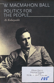
Book, Australian Scholarly Publishing Pty Ltd, W. Macmahon Ball: Politics for the People by Ai Kobayashi, 2013
William Macmahon Ball was a seminal figure in the development of the discipline of political science in Australia. His pioneering efforts at the University of Melbourne from the early 1930s culminated in the establishment of a separate Department of Political Science in 1939, an achievement at least a decade ahead of other Australian universities. The Balls lived in Eltham.xiv, 278 pages, 8 unnumbered pages of plates : illustrations, portraits ISBN 9781921875915william macmahon ball -
 Warrnambool and District Historical Society Inc.
Booklet, Allansford Progress Association, Second half of 20th century
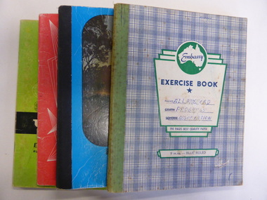
These four exercise books give documentation on the activities of the Allansford Progress Association (1966 to 1988). Allansford is a settlement about 9 kilometres from Warrnambool and most of the town area is now within the boundaries of the Warrnambool City Council. The association was re-formed in November 1966 after the demise of an earlier group. The members of the group campaigned in areas of local concern – T. V. reception, drainage and sewerage, postal services, sports facilities including the development of the Speedway, housing development, road proposals, waste management and disaster plans. These books are of interest in that they provide an overview of the history of a local organization. They will be useful for research. These are four exercise books - three Minutes books, and one Accounts book, from the Allansford Progress Association (1966-1988). The exercise books have coloured covers, (blue and white checkered, green, red and blue). Two are bound with tape and two are stapled. There are some loose sheets in all of the books. All the entries are handwritten. On front covers: ‘Allansford Progress Association’allansford progress association, history of allansford, history of warrnambool -
 Warrnambool and District Historical Society Inc.
Article - Fletcher Jones Gardens Warrnambool, 1993
The article gives an overview of the development of the landscaping of factory gardens in the early part of the 20th century. The Fletcher Jones Gardens feature strongly and a brief history is given of the establishment of the Fletcher Jones factory. Fletcher Jones Factory held a significant place in the economic development of the city. The Fletcher Jones Gardens remain a significant landmark in the cityArticle titled “Fletcher Jones Gardens Warrnambool,” printed with blue background. Three coloured photographs showing different vistas of the gardens.warrnambool, fletcher jones, pleasant hill, fletcher jones gardens -
 Warrnambool and District Historical Society Inc.
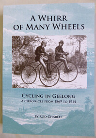
Book, Rod Charles, A whirr of many wheels, 2013
A history of cycling in the Geelong area from 1869 to 1914.Pale green and white soft cover depicting an illustration of buildings around the shores of Corio Bay taken from an engraving 1860. 585 Pages. Sepia coloured drawing of two men on bicycles. Title is in black text. One of three volumes.non-fictionA history of cycling in the Geelong area from 1869 to 1914.warrnambool, geelong cycling,, early cycling in victoria -
 Warrnambool and District Historical Society Inc.
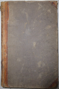
Document - Ledger: Warrnambool Shire Correspondence Letter Book, 1871-1875, Circa 1870
A detailed continuum of correspondence showing the progress of development in the district and the co-operation and cost sharing between the different shires to have work completed. This collection of letters provides a very good overview of issues and work covered in the early settlement days of the district. Cover is brown watermarked patterned cloth with tan suede binding and corners. Inside front and back covers is green and red patterned paper. Alphabetical index at the front. The ledger contains copies of letters which were written to local shires and lands Departments and relate mainly to matters of infrastructure and local government charges There are a number of invoices at the back of the book.: Letter Book No. on spine. Gold lettering on red. Serial numbers, signatures, engravings, dedications in books, manufacturing details or personal markingswarrnambool, warrnambool shire, hampden shire, mount rouse shire, geelong to belfast road, alfred davies, 1873-1875, shire correspondence -
 Warrnambool and District Historical Society Inc.
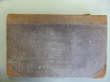
Document - Ledger: Warrnambool Shire Letter book 1861-1865, Circa 1860
Contains correspondence pertaining to matters of infrastructure in the period of the 1860’s. The period contained within this ledger is very early in the establishment of the district. It shows the co-operation and initiative between councils, government departments and individuals in matters relating drainage, bridges , roads all vital to the development of the region.Fawn cloth on card cover with tan corner and spine binding. Contains alphabetical index at the front. Letters are written on very fine paper.: On the spine is a paper label, “January1861-April 1865.Label inside front cover “Sands &Kenny. Account Book Manufacturers, Stationers &Printers, Collins St Melbourne. The index contains the following names :W G Allan, Bostock, Biggs, Bench of Magistrates Caramut, Niel Black, Commissioner of the Crown Lands Warrnambool, Commissioner of Roads and Bridges, Cross, Carr, Duffy, Davies, Duffus, Fitzmaurice, Horace Flower warrnambool, warrnambool shire, tenders, district roads board, a davies, 1861-1865 -
 Eltham District Historical Society Inc
Photograph, View at Eltham, Vic, c.1924
Copy of possible Rose Stereograph Co. postcard “View at Eltham, Vic.”, c.1924 looking southwest from Main Road near York Street to Bridge Street and the original 1875 bridge across what is now the Alistair Knox Park The land in the foreground was first bought from the Crown by J.M. Holloway in 1851. The land was sub-divided and called "Little Eltham". Bridge Street was created as part of the sub-division. Most of the sub-division was residential lots but the creek valley was divided into lots for small farms. Council started to buy the land for the Eltham Town park in the early 1960s. The area was used as a garbage tip and filled above the flood plain of the creek. Development of the land for a park began in the early 1970s. The house on the right was owned for many years by the Hill family until Council bought it in the early 1960s. The house was built in the 1850s or 60s. The house on the left stood on what is now the southwest corner of Susan and Bridge Streets. The Braithwaite family was associated with this house. The double line of fencing in the foreground was a continuation of York Street to the creek. The Bridge Street bridge was built in 1875 and replaced in 1958. (Ref: Early view of Little Eltham; Byways of History by Colleen Ison, Publication unk, 24 August 1982) Reproduced on p61 of 'Pioneers & Painters' Date estimated on same as View at Hurstbridge featuring Wattle Valley EstateThis photo forms part of a collection of photographs gathered by the Shire of Eltham for their centenary project book,"Pioneers and Painters: 100 years of the Shire of Eltham" by Alan Marshall (1971). The collection of over 500 images is held in partnership between Eltham District Historical Society and Yarra Plenty Regional Library (Eltham Library) and is now formally known as the 'The Shire of Eltham Pioneers Photograph Collection.' It is significant in being the first community sourced collection representing the places and people of the Shire's first one hundred years.Digital image 120 format B&W negative Prints 17 x 25 cm and 10 x 15 cmsepp, shire of eltham pioneers photograph collection, eltham, bridge street, bridge, alistair knox park, braithwaite, bridge street bridge, eltham town park, hill family home, main road, pioneers and painters, york street -
 Eltham District Historical Society Inc
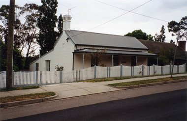
Photograph, Margaret Ball, Stebbing's Cottage, 88 Pitt Street, Eltham, June 1999
One of the oldest houses in Eltham, the cottage was built around 1861 by pioneer builder George Stebbing whose family lived in it until the 1900s. It’s plain and simple style reflects the functional design of the house. George Stebbing was responsible for the construction of some of Eltham's principal township buildings, including the Uniting (former Methodist) church, St. Margaret's Anglican church (1861) and Shillinglaw Cottage (1879). The house is historically and aesthetically significant because it is a rare surviving example of the modest homes constructed for and by artisans within the early Eltham township and is a significant feature of the streetscape In the 1960s Albert Downing owned this propertyThe Margaret Ball (Pre 1960s Houses) Collection was a personal project initiated to mark the year 2000 and arose as a result of the disappearance of many pre-1960s parts of Eltham due to development. Approximately 200 pre-1960s style houses that were left in Eltham between Main Road and east to Bible Street, between Cecil Street to the north and south to Dalton Street were photographed in late 1999. Not all of the houses could be photographed; some because the garden or trees blocked the view of the house, others because of rubbish or cars were in the way, some because people were working on the house or in the gardens at the time.Colour photographic print eltham, houses, streets, margaret ball (pre 1960s houses) collection, pitt street, stebbing's cottage, downing -
 Orbost & District Historical Society
book, Department of Education Victoria, The School Paper, December 1900
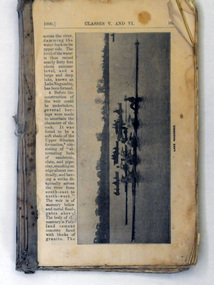
"Having a monthly circulation of 211,670 copies, the Victoria "School Paper" is claimed by the Education department to form the staple provision for leading matter in the elementary schools." -( December 29, 1920, The Argus). In Victoria the Education Department's School papers were compulsory reading for children until the 1930s when the Victorian readers became compulsory and the School Papers supplemented them. This one is for Grades V and VI.This item is an example of a school text book used in the very early 20th century. School textbooks reflect the development of education in Australia.From them we can understand what was taught and how children learned in Australian schools in earlier times.A collection / compilation of magazines called the "The School Paper". Binding is string and the back cover is cloth covered. on front - "William Brown"education school-reader the-school-paper-1900 -
 Orbost & District Historical Society
book, The School Paper, August 1902
"Having a monthly circulation of 211,670 copies, the Victoria "School Paper" is claimed by the Education department to form the staple provision for leading matter in the elementary schools." -( December 29, 1920, The Argus). In Victoria the Education Department's School papers were compulsory reading for children until the 1930s when the Victorian readers became compulsory and the School Papers supplemented them. This item is an example of a school text book used in the very early 20th century. School textbooks reflect the development of education in Australia.From them we can understand what was taught and how children learned in Australian schools in earlier times.A collection /compilation of The School Paper magazines. It has a hard cloth cover with string binding. The front cover is brown and the spine has blue and white stripes. Pasted on the inside cover is a photo of a school group.education reader the-school-paper-1902 -
 Orbost & District Historical Society
book, Stanley,Paul & Company, The Lady's Realm, November 1910 - April 1911
The Lady's Realm was a illustrated monthly women's magazine published in London in the 19th century, initially edited by W. H. Wilkins. It also published 36 volumes between 1896 and 1914. The Lady's Realm was a British women's magazine published from 1896 until 1914, possibly until 1915. It primarily targeted upper-class readers as well as an aspirational middle-class audience, featuring photographs, poems, fiction, and columns by popular authors such as Marie Corelli, Frances Hodgson Burnett, Jack London, and H.G. Wells. (Wikipedia) Founded in 1833, the Sydney Mechanics' School of Arts is the longest running School of Arts (also known as a "Mechanics' Institute") and the oldest continuous lending library in Australia. These magazines reflect women's interests in the early 20th century. Women’s magazines developed rapidly through the 1800s, reflecting both marketing developments and social changes. As the century progressed, publications aimed at women changed from the middle-class drawing-room journals of the 1830s and 1840s to the cheaper, chattier, more domestic magazines of the 1880s and 1890s. This item oi an example of a publication aimed at a particular social class.A thick hard back book with a dark blue and red fabric cover. It contains short stories by various authors. "SYDNEY MECHANICS SCHOOL OF ARTS 225 PITT STREET" on front cover.literature-lady's-realm short-stories