Showing 173515 items matching "nellie-street"
-
 Bendigo Historical Society Inc.
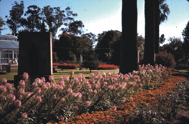
Slide - CHS, CONSERVATORY GARDENS, BRIDGE STREET, BENDIGO, 1979
Slide. CHS, Conservatory Gardens, Bridge Street, Bendigo. View of the Conservatory Gardens from the corner of Bull and Bridge streets. Date: 7.4.79slide, bendigo, conservatory gardens bendigo, slide chs, conservatory gardens, bridge street, bendigo 1979 -
 Tatura Irrigation & Wartime Camps Museum
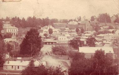
Photograph, Tatura Bird's Eye
Bird's eye view of Tatura; features Criterion Hotel, Hogan Street, Hogan Street Railway Crossing, Horse-drawn cart, fences.tatura, buildings, historic, transport, railway, horse -
 Clunes Museum
Photograph
POSTCARD SENT TO MRS. MC LENNAN, MARLBOROUGH, ROCKHAMPTON, QUEENSLAND FROM E.M.S.POSTCARD - OVERVIEW OF CLUNES - TAKEN FROM TOP OF CAMERON STREET HILL - SHOWING FRASER AND SERVICE STREET CORNER, SHOPS AND BUILDINGS. =1159Addressed to Mrs. L. McLennan Olive Marlborough Rockhampton Queensland Message With best wishes for a happy New Year E.M.S.local history, document, postcard, clunes township -
Whitehorse Historical Society Inc.
Article, Basin not the answer, claims flooding victim, 1993
A retarding basin in Scott Street, Vermont is proposed to prevent flooding in Barbara Street, but former resident, Ms Daly is sceptical of its efficiency.A retarding basin in Scott Street, Vermont is proposed to prevent flooding in Barbara Street, but former resident, Ms Daly is sceptical of its efficiency.A retarding basin in Scott Street, Vermont is proposed to prevent flooding in Barbara Street, but former resident, Ms Daly is sceptical of its efficiency.city of nunawading., barbara street, vermont, scott street, vermont, daly, belinda, ward, kelvin -
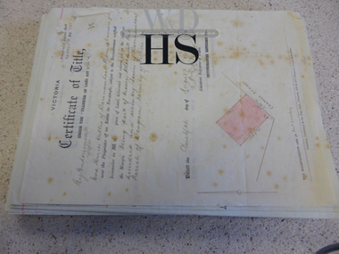
 Whitehorse Historical Society Inc.
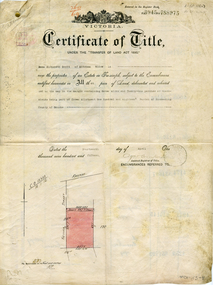
Legal record - Document, Certificate of Title - Scott, 14/04/1915 12:00:00 AM
Certificate of Title dated 14/4/1915 in the name of Emma Elizabeth Scott.Certificate of Title dated 14/4/1915 in the name of Emma Elizabeth Scott. Land bounded by Victoria Street and Scott Street, MitchamCertificate of Title dated 14/4/1915 in the name of Emma Elizabeth Scott.land titles, scott, emma elizabeth, scott street, mitcham, victoria street -
Whitehorse Historical Society Inc.
Article, Mitcham plan under way, 1986
Article stating that Edward Street, Mitcham will be closed for redevelopment of Mitcham Shopping Centre and the removal of the Guide Hall in Britannia Street to Halliday Park.Article stating that Edward Street, Mitcham will be closed for redevelopment of Mitcham Shopping Centre and the removal of the Guide Hall in Britannia Street to Halliday Park.Article stating that Edward Street, Mitcham will be closed for redevelopment of Mitcham Shopping Centre and the removal of the Guide Hall in Britannia Street to Halliday Park.edward street, mitcham, mitcham shopping centre, mitcham guides, britannia street, halliday park -
 Whitehorse Historical Society Inc.
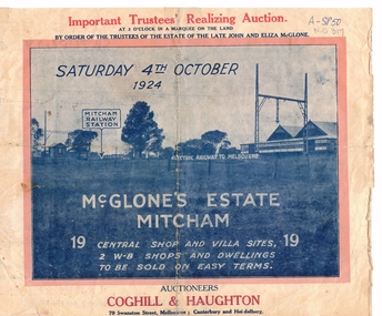
Document, McGlone Estate Mitcham
Pamphlet on auction of McGlone's Estate,Pamphlet on auction of McGlone's Estate, Mitcham 1924. Bordered by McGlone Street, Whitehorse Road, Station Street and Mitcham Railway line and stationPamphlet on auction of McGlone's Estate, land sales, auctions, mcglone estate, mcglone, john, elizabeth, station street, mitcham, whitehorse road, mitcham railway station, coghill & haughton -
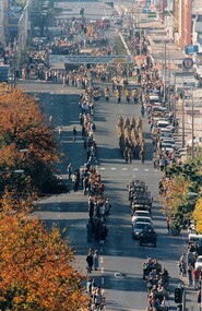 8th/13th Victorian Mounted Rifles Regimental Collection
Photograph
Colour photograph of Anzac Day March in Dean Street Albury,1994.Photographer positioned in elevated position at western end of Dean Street. -
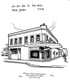 Port Melbourne Historical & Preservation Society
Drawing - Property sketch - 201-205 Ross Street, Struck & Spink Graphics P/L, 19 Aug 1992
Property sketches done for Frank Gordon Real Estate in the 1990s. 201- 205 Ross Street (corner Bridge Street). Milk Barbuilt environment - commercial, frank gordon & co, ross street -
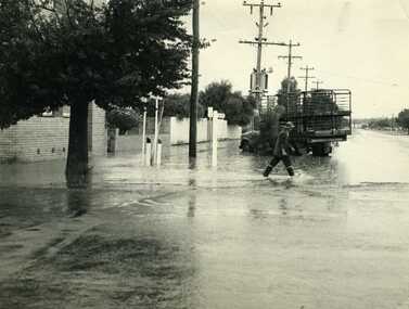 Charlton Golden Grains Museum Inc
Photograph, Cameron, Ian, 1972 Flash Flood, Jan 1972
1972 Flash flood, cnr of High St and Armstrong St, Charlton.B/W photograph of 1972 flash flood Corner High Street & Armstrong Streets. Man crossing road through flood water.flood, charlton, armstrong street -
 Kew Historical Society Inc
Plan, Melbourne and Metropolitan Board of Works, Borough of Kew : Detail Plan No.1580, 1904
The Melbourne and Metropolitan Board of Works (MMBW) plans were produced from the 1890s to the 1950s. They were crucial to the design and development of Melbourne's sewerage and drainage system. The plans, at a scale of 40 feet to 1 inch (1:480), provide a detailed historical record of Melbourne streetscapes and environmental features. Each plan covers one or two street blocks (roughly six streets), showing details of buildings, including garden layouts and ownership boundaries, and features such as laneways, drains, bridges, parks, municipal boundaries and other prominent landmarks as they existed at the time each plan was produced. (Source: State Library of Victoria)This plan forms part of a large group of MMBW plans and maps that was donated to the Society by the Mr Poulter, City Engineer of the City of Kew in 1989. Within this collection, thirty-five hand-coloured plans, backed with linen, are of statewide significance as they include annotations that provide details of construction materials used in buildings in the first decade of the 20th century as well as additional information about land ownership and usage. The copies in the Public Record Office Victoria and the State Library of Victoria are monochrome versions which do not denote building materials so that the maps in this collection are invaluable and unique tools for researchers and heritage consultants. A number of the plans are not held in the collection of the State Library of Victoria so they have the additional attribute of rarity.Original survey plan, issued by the MMBW to a contractor with responsibility for constructing sewers in the area identified on the plan within the Borough of Kew. The plan was at some stage hand-coloured, possibly by the contractor, but more likely by officers working in the Engineering Department of the Borough and later Town, then City of Kew. The hand-coloured sections of buildings on the plan were used to denote masonry or brick constructions (pink), weatherboard constructions (yellow), and public buildings (grey). The area represented in this detail plan has undergone significant change during the 20th century. The widening of High Street in the 1930s and 1950s involved the shops on the south side of High Street being demolished and later rebuilt to fit the widened street. Another significant loss was the mansion ‘Drayton’ fronting Wellington Street, owned at this stage by Susannah Fenton. Her family name would later to be given to Fenton Way, which was to be built over the grounds of the house following its demolition. The plan of the garden is particularly interesting, containing a batten dome fronting Wellington Street, an ornamental pond, a fountain and a brick and glass conservatory. The notes by the plumbing contractor on this plan are particularly detailed. Pink borders delineate the ownership of the varying parcels of land. Some of the better known owners listed include the real estate agent Cr. Henry de Castres Kellett (bt) and John Padbury, the funeral director. This particular plan provides a clear view of the configuration of the Kew Junction in 1903 and the commercial buildings that surrounded it.melbourne and metropolitan board of works, detail plans, maps - borough of kew, mmbw 1580, cartography -
 Kew Historical Society Inc
Plan - Subdivision Plan, Normanby Estate, East Kew, 1913
Pru Sanderson, in her groundbreaking ‘City of Kew Urban Conservation Study : Volume 2 - Development History’ (1988), summarised the periods of urban development and subdivisions of land in Kew. The periods that she identified included 1845-1880, 1880-1893, 1893-1921, 1921-1933, 1933-1943, and Post-War Development. These periods were selected as they represented periods of rapid growth or decline in urban development. An obvious starting point for Sanderson’s groupings involved population growth and the associated economic cycles. These cycles also highlighted urban expansion onto land that was predominantly rural, although in other cases it represented the decline and breakup of large estates. A number of the plans in the Kew Historical Society’s collection can also be found in other collections, such as those of the State Library of Victoria and the Boroondara Library Service. A number are however unique to the collection.The Kew Historical Society collection includes almost 100 subdivision plans pertaining to suburbs of the City of Melbourne. Most of these are of Kew, Kew East or Studley Park, although a smaller number are plans of Camberwell, Deepdene, Balwyn and Hawthorn. It is believed that the majority of the plans were gifted to the Society by persons connected with the real estate firm - J. R. Mathers and McMillan, 136 Cotham Road, Kew. The Plans in the collection are rarely in pristine form, being working plans on which the agent would write notes and record lots sold and the prices of these. The subdivision plans are historically significant examples of the growth of urban Melbourne from the beginning of the 20th Century up until the 1980s. A number of the plans are double-sided and often include a photograph on the reverse. The Normanby Estate, which was adjacent to Normanby Road, Kew East, included thirty-one lots for sale. Streets on the subdivision plan include Adeney Avenue, Park Hill Road, Normanby Road, Weir Street and Wharton Street. Cotham Road and its tramway are shown nearby. The plan is interesting as it shows Wharton Street, named after the architect and town planner George Wharton, who was the first chairman of the Municipality of Kew. The street was to later be renamed Cecil Street. Also shown are proposed ‘Municipal Gardens’ where Parkhill Drive is now located.subdivision plans - kew, normanby estate -
 Warrnambool and District Historical Society Inc.
Document, Accounts, Early and Middle 20th Century
These pages of accounts are from the firm of Mackay Taylor, Lawyers, a prominent firm in Warrnambool for over 100 years. The Warrnambool legal businesses of George Mackay and James Fletcher merged in 1893 and was known as Fletcher and Mackay. In the 1920s Mr Mackay took J. McD Taylor as a partner and the premises at 131 Kepler Street were built about that time, with the firm being known as Mackay and Taylor. After the original partners died there was a succession of partners with the legal firm continuing as Mackay Taylor until the 1990s. These account sheets from a prominent 20th century legal firm in Warrnambool are of considerable importance as they document the legal records of many Warrnambool and district personalities from the early 20th century. The information contained in the sheets will therefore add to the known history of many local people from the past and will be very useful to researchers.These are handwritten accounts for bills to be paid to Mackay Taylor Lawyers for services rendered. The accounts are described in detail and are written on quarto size paper with the requisite red lines already printed on the pages. There are over 100 sheets and they date from 1938 to 1940. There are also two original Certificates of Title for Eva Willis (1916, portion of land in Cramer Street) and Archie Jackson (1924, portion of land in Cramer Street). warrnambool, warrnambool lawyers -
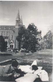 Northern District School of Nursing. Managed by Bendigo Historical Society Inc.
Photograph - Photo of first year nurses
The Northern District School of Nursing opened in 1950 in to address the issues around nurse recruitment, training and education that had previously been hospital based. The residential school was to provide theoretical and in-house education and practical training over three years. The students would also receive practical hands-on training in the wards of associated hospitals. The Northern District School of Nursing operated from Lister House, Rowan Street, Bendigo. It was the first independent school of nursing in Victoria and continued until it closed in 1989.Black and white photo of two nurses, from school 43, in civilian clothes relaxing outside the Hostel in Wattle Street. The Sacred Heart Cathedral is in the background. In biro on reverse - Weekend photo at Wattle Street Hostel. On a separate sheet the following information in biro- At Wattle St. Hostel. Sacred Heart Cathedral in background. Weekend relaxing. L-R 1. Jan Goss 2. Louise Murphy -
Glenelg Shire Council Cultural Collection
Souvenir - Badge - Portland State School no. 489. Vic 100th anniversary, c. 1934
Palmer Street Primary School, now rebranded to Portland Primary School.Badge, Portland State School (Palmer Street) no. 489. Vic 100th anniversary. Round, metal, pin on reverse, obverse black and white, view of front of school, from Palmer St. 'ONE HUNDREDTH ANNIVERSARY STATE & PORTLAND' round top edge. 'PORTLAND SCHOOL NO 489 1934' round lower edge. Measures 3 cm diameter. -
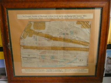 Bendigo Historical Society Inc.
Document - PLAN OF TOWNSHIP OF SANDHURST 1854, July 25. 1854
Coloured- The planned township of Sandhurst is placed over the early Bendigo creek township of 1854. The two main streets of the early township were Camp and Auction streets. The street shown as Dowling street later became Queen & Hopetoun streets. The building near the bridge at View Point is Pykes Building. The Post Office was located here in 1854 - 58. Bernal street is now Chapel street. The creeks were straightened to their present courses. Streets on map are. Pall Mall - Bridge - McCrae - Hargraves - Lyttleton - Myers - Mollison - McLaren - Mitchell - Williamson - Mundy - Bernal - Baxter - Larritt - Bramble - McIvor - Bull. Also shown on map: Bendigo Creek - Government Reserve - Present Cemetery - Proposed diversion of creek. FH 562 Deframed 2022Lithographed at Surveyor Generals Office. Melbourne. July 25. 1854. By R. Meikle.place, bendigo, original 1854 bendigo map -
Glenelg Shire Council Cultural Collection
Photograph - Copy of Photograph - Percy Street, Portland, Victoria, 1859
Vern Mc Callum CollectionDigital copy of monochrome photo taken in Portland in 1859. View of west side of Percy Street between Tyers and Henty Street. Several men standing on footpath. Man in horse and buggy. Another horse and buggy staning empty in street. -
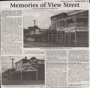 Bendigo Historical Society Inc.
Newspaper - JENNY FOLEY COLLECTION: MEMORIES OF VIEW STREEET
Bendigo Weekly, Friday 27, July 2001. Memories of View Street - a snippet of Bendigo history, by Edith Lunn - An article describing the small businesses that flourished in View Street from the corner of Barnard Street to View point. The clip is in a folder.newspaper, bendigo, bendigo weekly -
Port Melbourne Historical & Preservation Society
Photograph - 41 to 71 Evans Street, Port Melbourne, Meredith Turnbull, Dec 1996
Meredith Turnbull photographed this series in 1996 to record the rapidly changing streetscape, which had already had a number of old houses replaced by concrete two-storey structures under the State government's urban consolidation policyFrom a series of 70 colour photos recording all buildings in Evans Street from Graham Street overpass to Ingles Street, as photographed from the railway reservation, by Meredith Turnbull in December 1996 - wider view of numbers 41 to 71House numbers noted on backbuilt environment - domestic, meredith turnbull -
Port Melbourne Historical & Preservation Society
Photograph - 52 Evans Street, Port Melbourne, Meredith Turnbull, Dec 1996
Meredith Turnbull photographed this series in 1996 to record the rapidly changing streetscape, which had already had a number of old houses replaced by concrete two-storey structures under the State government's urban consolidation policyFrom a series of 70 colour photos recording all buildings in Evans Street from Graham Street overpass to Ingles Street, as photographed from the railway reservation, by Meredith Turnbull in December 1996 - number 52 'Tring Cottage' closeupHouse numbers noted on backbuilt environment - domestic, meredith turnbull -
Port Melbourne Historical & Preservation Society
Photograph - 127 & 128 Evans Street, Port Melbourne, Meredith Turnbull, Dec 1996
Meredith Turnbull photographed this series in 1996 to record the rapidly changing streetscape, which had already had a number of old houses replaced by concrete two-storey structures under the State government's urban consolidation policyFrom a series of 70 colour photos recording all buildings in Evans Street from Graham Street overpass to Ingles Street, as photographed from the railway reservation, by Meredith Turnbull in December 1996 - number 127, 128 close-upHouse numbers noted on backbuilt environment - domestic, meredith turnbull -
Port Melbourne Historical & Preservation Society
Photograph - Turner Family home, 190 Nott Street (renumbered as 114 Nott Street), Port Melbourne, 1940s
B&W lasercopy, one of four on a page of photos of Bert Turner family home, 190 Nott Street: 114 Nott Street in the 1980s. (Nott Street numbers have changed; see also item 914 re furnishings)built environment - domestic, bert turner -
Port Melbourne Historical & Preservation Society
Photograph - 8, 9 & 11 Evans Street, Port Melbourne, Meredith Turnbull, Dec 1996
Meredith Turnbull photographed this series in 1996 to record the rapidly changing streetscape, which had already had a number of old houses replaced by concrete two-storey structures under the State government's urban consolidation policyFrom a series of 70 colour photos recording all buildings in Evans Street from Graham Street overpass to Ingles Street, as photographed from the railway reservation, by Meredith Turnbull in December 1996 - number 8, 9, 11 EvansHouse numbers noted on backbuilt environment - domestic, meredith turnbull -
Port Melbourne Historical & Preservation Society
Photograph - 43, 44, 45 & 46 Evans Street, Port Melbourne, Meredith Turnbull, Dec 1996
Meredith Turnbull photographed this series in 1996 to record the rapidly changing streetscape, which had already had a number of old houses replaced by concrete two-storey structures under the State government's urban consolidation policyFrom a series of 70 colour photos recording all buildings in Evans Street from Graham Street overpass to Ingles Street, as photographed from the railway reservation, by Meredith Turnbull in December 1996 - number 43, 44, 45, 46House numbers noted on backbuilt environment - domestic, meredith turnbull -
Port Melbourne Historical & Preservation Society
Photograph - Lily Cottage, 77 Evans Street, Port Melbourne, Meredith Turnbull, Dec 1996
Meredith Turnbull photographed this series in 1996 to record the rapidly changing streetscape, which had already had a number of old houses replaced by concrete two-storey structures under the State government's urban consolidation policyFrom a series of 70 colour photos recording all buildings in Evans Street from Graham Street overpass to Ingles Street, as photographed from the railway reservation, by Meredith Turnbull in December 1996 - two of number 77 (Lily Cottage)House numbers noted on backbuilt environment - domestic, meredith turnbull -
Port Melbourne Historical & Preservation Society
Photograph - 125, 126, 127 & 128 Evans Street, Port Melbourne, Meredith Turnbull, Dec 1996
Meredith Turnbull photographed this series in 1996 to record the rapidly changing streetscape, which had already had a number of old houses replaced by concrete two-storey structures under the State government's urban consolidation policyFrom a series of 70 colour photos recording all buildings in Evans Street from Graham Street overpass to Ingles Street, as photographed from the railway reservation, by Meredith Turnbull in December 1996 - number 125, 126, 127, 128House numbers noted on backbuilt environment - domestic, meredith turnbull -
Port Melbourne Historical & Preservation Society
Photograph - 151, 152, 153 & 154 Evans Street, Port Melbourne, Meredith Turnbull, Dec 1996
Meredith Turnbull photographed this series in 1996 to record the rapidly changing streetscape, which had already had a number of old houses replaced by concrete two-storey structures under the State government's urban consolidation policyFrom a series of 70 colour photos recording all buildings in Evans Street from Graham Street overpass to Ingles Street, as photographed from the railway reservation, by Meredith Turnbull in December 1996 - number 151, 152, 153, 154House numbers noted on backbuilt environment - domestic, meredith turnbull -
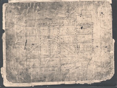 Bendigo Historical Society Inc.
Photograph - WES HARRY COLLECTION: TOWNSHIP OF SANDHURST, 1854
Photograph of the Parish Plan of the Township of Sandhurst in 1854. It covers the area of the CBD from Mitchell (not named) to Bernal Streets and from the Bendigo Creek to Mollison St. ( other than Pall Mall and McRae streets, none of these parallel streets are named)place, bendigo, first survey, sandhurst, first survey, bendigo creek -
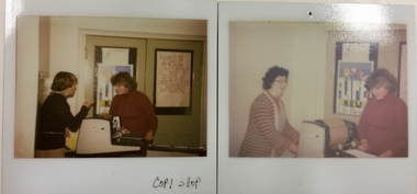 Kew Historical Society Inc
Photograph - 'Copy Shop', Old Masonic Hall, Walpole Street
The 'Copy Shop' in Walpole Street, Kew was located in the former Masonic Hall. It was a community operated facility. The 'shop' was designed for use by groups to run off leaflets or newsletters. It also served as a community space where people could drop in for a coffee and leave leaflets and information about events in the City of Kew. Two polaroid photographs, Thea Sartori in a red jumper is in both photographs. The woman in the pink cardigan is Aileen Cahill. Both photos were taken at the 'Copy Shop' in the old Masonic Hall [demolished] in Walpole Street. front: "Copy Shop"copy shop - walpole street - kew (vic), community facilities -- city of kew, masonic hall -- kew (vic.) -
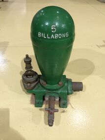 Puffing Billy Railway
Functional object - Billabong Ram Pump Size #5, Unknown
Pump - Billabong Ram Pump Size #5 Based on available historical data, the Australian-made Billabong Hydraulic Ram is one of the oldest rams produced anywhere in the world The Billabong Hydraulic Ram was first introduced into Australia in 1855 by John Danks and Son Limited, John Danks & Son Pty Ltd began as a plumbing business in 1859, established by brothers John and Samuel. It occupied a prominent site in Bourke Street, Melbourne, for 100 years. The business quickly grew to include factories in Melbourne and Sydney which manufactured and supplied a variety of plumbing and engineering products such as brassware, pumps, windmills and bells. The company was registered in Victoria on 25 January 1889 to continue the hardware manufacturing and supply business founded by brothers John and Samuel Danks in 1859. The head office was based in Bourke Street, Melbourne while another branch was established in Sydney in the 1880s. The company had factories in Melbourne and Sydney. The John Danks and Son Limited catalogue published in 1890, listing Billabong Hydraulic Rams as one of its major machinery products. The catalogue also provides reference to the company’s ram experience and manufacture, beginning by stating that in 1890 they already had 35 years of experience with Billabong Hydraulic Rams. The Hydraulic Ram has stood the test of time and it remains one of the few really practical and efficient uses of natural energy today. It operates without almost any cost, will last indefinitely and, with only two moving parts, is simplicity itself. It requires minimum maintenance and minimum replacement of parts. It is not uncommon to find rams working continuously for many years without any attention. • The Rams do not require electricity, fuel or steam to operate. • They possess simplicity of construction and operation – only 2 moving parts. • Powered only by running water. • Require very minimal or almost no maintenance. • Heavy duty cast Iron base and Dome. This Pump recovered from the Clematis Creek in the Mid 1970's Used to pump water from the creek to the Paradise (Clematis) Hotel. Historic - Farm Equipment - Used to pump water from the creek to the Paradise (Clematis) Hotel.Cast Iron Bronze valveBillabong 5billabong, puffing billy, ram pump