Showing 11159 items matching "planning "
-
 Ringwood and District Historical Society
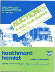
Flyer - Auction Sale, Heathmont Hamlet, Yarang Court and Westmore Drive, Heathmont, Victoria - 1978
Multi-fold promotional brochure with project home style images and floor plans. Six of 31 planned homes to be auctioned on Saturday 12th August, 1978. A project by Star Homes. Auctioneers/Agents - Bill Gefland, 71 Kooyong Road, Caulfield North. Ph: 5090211 AH. 203807, 8763939. Consultant - Enid M. Davies. Terms $6000 deposit, 3 year term interest 12% quart adj. 2 year term interest 10% quart adj. Home style images: The Atlas Ole, The Argo, The Atlas Pioneer, The Mira, The Alpha, The Libra, The Tucana, The Venus. Illustrated front cover - Libra 77. -
 University of Melbourne, Burnley Campus Archives
Plan, Richmond Park, 1926-1954
Photocopy of Section of a Survey Plan 1926 showing fencing and hedging dated 1927. Stamp, Department of Lands and Survey 8.9.54 (Original plan dated 25.3.27) Part of handwritten notes signed "M. Anderson ? 28/2/45."parks, richmond, burnley gardens, orchards -
 Flagstaff Hill Maritime Museum and Village
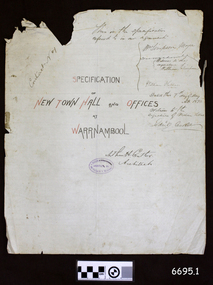
Legal record - Plans and Contract, Arthur H. Cutler, Architect, Warrnambool Town Hall, 1890-1892
This is a set of documents including three sheets of blueprint plans for the New Town Hall and Offices for Warrnambool, created in 1890 by the Architect Mr Arthur H. Cutler of Melbourne. The Contract was signed by the Town Mayor for Warrnambool, Mr William Simpson on May 7th 1890. Also, a Council copy of the Contract dated 26 June 1890, with the signatures and diagram where the two official stamps would be placed. The Foundation Stone was laid the following year by the next Mayor, John Hyland on February 24th 1891. The contractor for the building was granted to W. Kellas (William) of Warrnambool. The Town Hall and Offices were built on the corner of Liebig and Timor Streets in Warrnambool. On March 20th 1983 the new Performing Arts Centre was opened y the Mayor, Councillor R w Andreson, on the same site. The new building incorporates the 1890 Town Hall building. The plans, contracts, documents and various references to people on the documents are significant to the history of the City of Warrnambool and its community. The Warrnambool Town Hall building is also significant for the many community events held there over the decades after it was built. Appreciation for the significance of the almost century-old Town Hall building is demonstrated by its inclusion in the new Performing Arts Centre.Set of five documents that includes Plans for the Warrnambool Town Hall, the Contract cover page and a letter from the Architect to the Council. The Contract cover page and the Letter are hand written on cream-coloured paper with a waxy finish, with watermarks. 1) Contract Cover Page, 5th May 1890, Specification of the New Town Hall and Offices at Warrnambool. 2) Letter, 29th January 1892, from Architect Arthur H. Cutler to Mayor and Councilors, Town of Warrnambool 3) Blueprint Sheet 4, Longitudinal Section, and profiles of Liebig Street and Timor Street, Warrnambool Town Hall, 4) Blueprint Sheet 3, First Floor & Balcony Plan, and Roof Plan 5) Blueprint Sheet 2, Ground Floor Plan, Warrnambool Town Hall 6) Contract, 26 June 1890, marked (Draft Copy Tow Hall Contract), Between Mayor, Councillors and Rate Payers, and William Kellas, ContractorWatermarks on handwritten pages [horizontal lines], "36" "BUSBRIDGE'S / LOFT DRIED" Contract cover page, Oval stamp "CUTLER - 281 COLLINS ST. E. MELBOURNE - ARCHITECT " (other crossed out text) Handwritten script "This is the specifications referred to in our agreement" "Dated this 7th day of May A.D. 1890" Signed "W. Simpson Mayor" "Arthur H. Cutler Architect", [two Witnesses' signatures and others] Letter from Arthur Cutler, handwritten, has his address "472 Chancery Lane, Melbourne" CONTRACT of 26 June 1890: "The Mayor, Councillors and Rate Payers of Warrnambool" "William Kellas of Warrnambool" "Signed William Simpson, Maoyorr" "R F Kennedy, Councillor" "Wm Kellas" with diagrams where the round Common Seal and square Stamp would be applied.warrnambool, flagstaff hill, warrnambool, flagstaff hill maritime museum, maritime village, shipwreck coast, great ocean roaad, warrnamboo town hall, warrnambool council offices, mayor william simpson, arthur h cutler, architect, civic centre, town hall, performing arts centre, mayor john hyland, william kellas, mayor r w anderson, r f kennedy, contract -
 Kew Historical Society Inc
Plan - Subdivision Plan, Oswinia Estate, East Kew, c.1925
Prue Sanderson, in her groundbreaking ‘City of Kew Urban Conservation Study : Volume 2 - Development History’ (1988), summarised the periods of urban development and subdivisions of land in Kew. The periods that she identified included 1845-1880, 1880-1893, 1893-1921, 1921-1933, 1933-1943, and Post-War Development. These periods were selected as they represented periods of rapid growth or decline in urban development. An obvious starting point for Sanderson’s groupings involved population growth and the associated economic cycles. These cycles also highlighted urban expansion onto land that was predominantly rural, although in other cases it represented the decline and breakup of large estates. A number of the plans in the Kew Historical Society’s collection can also be found in other collections, such as those of the State Library of Victoria and the Boroondara Library Service. A number are however unique to the collection.Subdivision plans are historically important documents used as evidence of the growth of suburbs in Australia. They frequently provide information about when the land was sold on which a built structure was subsequently constructed as well as evidence relating to surveyors and real estate and financial agents. The numerous subdivision plans in the Kew Historical Society's collection represent working documents, ranging from the initial sketches made in planning a subdivision to printed plans on which auctioneers or agents listed the prices for which individual lots were sold. In a number of cases, the reverse of a subdivision plan in the collection includes a photograph of a house that was also for sale by the agent. These photographs provide significant heritage information relating house design and decoration, fencing and household gardens.The ‘Oswinia Estate’ subdivision in East Kew was planned and auctioned in the first half of the 1920s. 169 allotments were created in the triangular section of land bordered by High Street, Burke Road and the Government Boulevard (later Kilby Road). The only piece of land excluded was that where the previous Kew Pound had been located at the east tip of the triangle. Allotments were created fronting Glass, High, Namur, Oswin Streets, Irymple Avenue, and the Government Boulevard. The name for the Estate was derived from Oswin’s farm, which had been one of the largest landholdings in East Kew. The selling agents annotated the plan in our collection with crosses indicating those lots that had been sold. The inset locality plan is particularly interesting as it shows the route and stations of the Outer Circle Railway. When the subdivision plan was created, it included the proposed bridge over the Yarra at Burke Road. The bridge was to be officially opened in 1926.subdivision plans - east kew, oswinia estate, high street, glass street, namur street, government boulevard - kilby road, irymple street, oswin street -
 Bacchus Marsh & District Historical Society
Map, Plan of land purchased by the Bacchus Marsh Shire Council from Mr. T. Low for a deviation of the Melbourne to Ballarat main road. 1877
The date of this plan is 1877 and the land indicted on it required for a road deviation is shaded in blue. It adjoins the Korkuperrimul Creek on one side which indicates the land is located just a few kilometers to the west of Bacchus Marsh. Single page map showing a portion of land purchased by the Bacchus Marsh Shire from Mr Thomas Low for the purpose of a road deviation. Land held by David Robertson is also shown on the map. Scale: 2 chains to 1 inch. Part of a set of maps which are pasted into a bound volume containing 76 maps or plans in total. High resolution digital image stored on BMDHS computer network. Surveyed by W. E. Standfield, Shire Engineer, Bacchus Marsh, 12/4/77bacchus marsh roads and streets, melbourne to ballarat road -
Glenelg Shire Council Cultural Collection
Plan - Plans / Line Drawings - Port of Portland Authority, Victoria, 24/06/1972
PORT OF PORTLAND AUTHORITYFront: '48' - black texta, top right corner -
 University of Melbourne, Burnley Campus Archives
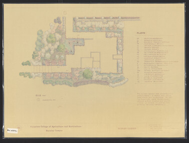
Plan, James Hitchmough, Sunken Garden, 1981-1989
Most plans were held in Geoff Olives's office.(1) Sunken Garden. 1 tracing paper copy and 1 paper, laminated, coloured. Designed by Dr. James Hitchmough, drawn by Jill Kellow c1989. Plants supplied by Victorian Wholesale Nurseries Pty. Ltd. (2) The Sunken Garden. 1 tracing paper, partly coloured, 1 paper copy. Designed by James Hitchmough, drawn by Jill Kellow 20.12.1988. (3) Burnley Horticultural College Gardens Development Sunken Gardens: Plan Proposal I, March 1981 on tracing paper. (4) Burnley Horticultural College Gardens Development Formal Sunken Garden Proposal 2, March 1981 on tracing paper. (5) Burnley Horticultural College Sunken Garden Scheme II by G. Olive on tracing paper. Plants supplied by Victorian Wholesale Nurseries P.L. sunken garden, james hitchmough, jim kellow, andrew smith -
 Melbourne Tram Museum
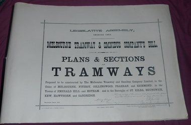
Document - Folder, Jack Cranston, "Melbourne Tramway & Omnibus Company's Bill - Plans and Sections - Tramways - March 1882", 1994
Consists of five sheets with notes about the proposed horse tram system for Melbourne, prepared by Jack Cranston. Includes extract and notes on the parliamentary enquiry and the possibility of a cable tram system. The coloured sheet is from another copy held at the former VicTrack Malvern Museum. Images from the latter set of documents - Sept 2024. 35 Sheets of details on the plans and sections of proposed horse tram lines throughout Melbourne. Produced as part of the work undertaken by Jack Cranston for the Department of Transport / Heritage Victoria - see Reg Item 584. On rear cover ink and on page 2 of the folder is a note on the source of the document. See Inscriptions.Yields information about the proposed horse tram lines by MTOCo that were later developed as cable tram lines.Folder - photocopies or copy prints, A1 approx. size, 45 sheets, clipped together with two black side binders, titled - "Melbourne Tramway & Omnibus Company's Bill - Plans and Sections - Tramways - March 1882". On rear cover sheet, handwritten in black ink - "Constructed and compiled by Jack Cranston by permission from The Ambleside Museum Ferntree Gully Victoria. This is a copy of Original Size Folio"trams, tramways, cable trams, horse trams, mto co, melbourne -
 Kew Historical Society Inc
Plan - Subdivision Plan, High Street, Kew, 1920-1935
Pru Sanderson, in her groundbreaking ‘City of Kew Urban Conservation Study : Volume 2 - Development History’ (1988), summarised the periods of urban development and subdivisions of land in Kew. The periods that she identified included 1845-1880, 1880-1893, 1893-1921, 1921-1933, 1933-1943, and Post-War Development. These periods were selected as they represented periods of rapid growth or decline in urban development. An obvious starting point for Sanderson’s groupings involved population growth and the associated economic cycles. These cycles also highlighted urban expansion onto land that was predominantly rural, although in other cases it represented the decline and breakup of large estates. A number of the plans in the Kew Historical Society’s collection can also be found in other collections, such as those of the State Library of Victoria and the Boroondara Library Service. A number are however unique to the collection.The Kew Historical Society collection includes almost 100 subdivision plans pertaining to suburbs of the City of Melbourne. Most of these are of Kew, Kew East or Studley Park, although a smaller number are plans of Camberwell, Deepdene, Balwyn and Hawthorn. It is believed that the majority of the plans were gifted to the Society by persons connected with the real estate firm - J. R. Mathers and McMillan, 136 Cotham Road, Kew. The Plans in the collection are rarely in pristine form, being working plans on which the agent would write notes and record lots sold and the prices of these. The subdivision plans are historically significant examples of the growth of urban Melbourne from the beginning of the 20th Century up until the 1980s. A number of the plans are double-sided and often include a photograph on the reverse. A number of the latter are by noted photographers such as J.E. Barnes.A roughly drawn and faded actual or projected subdivision of a parcel of land bordering on High and Mary Streets. The plan shows five allotments facing High Street and at their rear, another allotment facing Mary Street. In 1906, when the Board of Works surveyors completed Detail Plan 1589, the allotment in Mary Street is shown to include a building. The section of land attached to this building is shown to be undeveloped, thus making a further subdivision possible.subdivision plans - kew, high street -- kew (vic.), mary street -- kew (vic.) -
University of Melbourne, Burnley Campus Archives
Plan, Methodist Ladies College, 1986 -1988
(1) Site Plan showing Carparking by Hayball Sanderson & Partners Job No 86/142. Drawing No A1. Scale 1:55. November 1986. (2) Master Plan Courtyard Design by Richard Nosworthy, 8.11.88 Sheet No 2 (of 2) Elevation. (3) Master Plan MLC by Michael Doensen 8.11.88. Scale 1:100 Sheet No 1 of 2 Courtyard Planting Plan.Names: Cath Coates, Darren Wilson added in inkrichard nosworthy, michael doensen, methodists ladies college, kew -
Linton and District Historical Society Inc
Floor plan, Floor plan - Linton State School No. 880
A3 size photocopy showing floor plan and east side elevation of Linton State School building. The plan appears to show where new flooring will be required. The number W144563 is written in the top right hand corner. The plan is not clearly dated, however the initials "R. P." followed by the numbers "10/57" suggests that this plan may have been drawn up in 1957.linton state school no. 880, maps and plans, floor plan -
Port Melbourne Historical & Preservation Society
Plan, John James Wild, Architect, New Town Hall Sandridge 1881, 1 Jan 1881
Laminated copy from City collection, elevation plans for new Town Hall Sandridge 1881. .01 - front elevation .02 - rear elevation .03 - transverse section .04 - ground floor plan - A3 copy .05 - first floor plan - A3 copyarchitecture, port melbourne town hall, town clerks, built environment - civic, sandridge town hall, john james wild, edward clark -
University of Melbourne, Burnley Campus Archives
Work on paper (item) - Student Work, Lucas McGarrigle, Landscape Design Plan, 2018
Made as an assignment for HORT90035, a subject at Burnley Horticultural College coordinated by Andrew Laidlaw. assignment, landscaping, burnley horticultural college, landscape construction and graphics, hort90035 -
 Kew Historical Society Inc
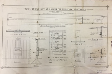
Plan, JC Brown, Detail of Step Butt and Screen for Miniature Rifle Range, 26 February 1910
On 19 July 1907, The Box Hill Reporter published an article on the Miniature Rifle Range. It stated: "Miniature Rifle Range for Kew. The Kew rifle club has made arrangements for the establishment of a miniature rifle range. The Kew borough council has provided a site in the yard at the rear of the town hall, fronting Brougham street. The site has been inspected by the military authorities, who have approved of the locality selected and the arrangements to be made to render the range absolutely safe. The plans are at present being prepared, and it is expected that the range will be completed within the next two months. The range will be under the direct control of the rifle club, subject to the supervision of a joint committee from the council and the club. The first committee will consist of Crs Wishart (mayor), Kellett, and Hiscock as representing the council, and Captain Argyle and Mr S. Abbott representing the rifle club. The range when completed will be available for the use of cadets, friendly societies, and other miniature rifle clubs in the district. Miniature rifle ranges are now occupying a great deal of attention in Great Britain, on the Continent, and in America. Lord Roberts, writing recently on the subject, remarks- "While I do not for a moment pretend that miniature rifle shooting is, in all respects, as useful as knowing how to shoot on a long range, I am satisfied that men can learn to shoot on miniature ranges, and that unless miniature ranges are very generally made use of, the greatest majority in this country will never learn to shoot at all." It is possible by this means also to divert the at present dangerous enthusiasm of uninstructed youths for the pea rifle into safer and more useful channels."Important early document identifying the specifications for a miniature rifle range in central Kew. Rifle clubs and rifle ranges were an important element in defending Victorians and Australians to outside threats. Single page plan (folded), created and approved in 1910, listing the approved specifications for a miniature rifle range in Brougham Street, Kew.Handwritten signature: J.M. / Staff officer for Works Victoria / 26-2-10rifle clubs - rifle ranges, miniature rifle ranges, rifle clubs -- kew (vic) -
Glenelg Shire Council Cultural Collection
Plan - Plan - early Portland, n.d
Early plan drawing of PortlandHand-drawn plan on paper, glued on linen backing. Plan shows layout of properties and a lagoon. Hand-tinted in colour. Names of property owners written on lots.plan, map, town, portland -
Federation University Historical Collection
Plans, Ballarat School of Mines architectural plans, 1 - .2) 1984 .3) 1948
.1) Printed plan: Ground floor existing Ballarat East Free Library .2) As above .3) Copy of plan drawing: Additional room to plumbing shop[ plans, smb, g macgregor, percy everett, plumbing, ballarat east library, ballarat school of mines -
Federation University Historical Collection
Report, Emma Nuttall, Goldfields Consultancy Proposal, 2002-5, 1995
.1) Strategic Plan for Goldfields Region: Consultancy Proposal .2) A Strategic Marketing Plan by four students of Tourism at the University of Ballarat relating to Victoria's Goldfields Region.victorian tourisim industry, tourism, goldfields, victorian goldfields -
Port Melbourne Historical & Preservation Society
Document - Specification, Metalling and chanelling, Rouse Street between Esplanade East and Esplanade West, Engineering Department, Town of Port Melbourne, 14 Mar 1893
Specification for tram and road works in Rouse Street between Esplanades East and West and adjacent to Lagoon Loan Works 1893 plan 19; relates to plan 99.2.Signed by JJ Bartlett (Mayor) 14.3.1893engineering - roads streets lanes and footpaths, sandridge lagoon, transport - tramways, arthur victor heath, town clerks, james john bartlett, mayors -
Port Melbourne Historical & Preservation Society
Plan - Tram and roadworks, Rouse Street between Esplanade East and Esplanade West, Engineering Department, Town of Port Melbourne, Mar 1893
Plan for tram and road works in Rouse Street between Esplanades East and West and adjacent to Lagoon Loan Works 1893 plan 19; relates to specification 99.1Signed by JJ Bartlett (Mayor) 14.3.1893engineering - roads streets lanes and footpaths, sandridge lagoon, transport - tramways, arthur victor heath, town clerks, james john bartlett, mayors -
Port Melbourne Historical & Preservation Society
Plan - Possible maritime shed, Borough of Sandridge, 1870s
An identified building plan - presumably a maritime shed (front elevation faces "the river") - proving front, traverse and longitudinal sections. Possibly two buildings. Plan No. 3.Charles Clay B.S. [Borough Surveyor]:W. Weatherston[e]built environment - civic, piers and wharves, charles clay, william weatherston[e] -
Port Melbourne Historical & Preservation Society
Document, Melbourne and Metropolitan Board of Works, 31 Oct 1935
Documentation of drainage works in 1935 for 141 Bridge St.Plan of drainage 31/10/1935. Details the Melbourne and Metropolitan Board of Works drainage plan for part of Port Melbourne. 141 Bridge St, Port MelbourneHand written details around blueprint of area. Notes made on right hand side and 3 signatures at the bottom.built environment - civic, built environment - domestic, engineering - board of works, melbourne and metropolitan board of works, mmbw, m h grover, r f bentley -
 Bendigo Historical Society Inc.
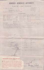
Document - L. PROUT COLLECTION: PLAN OF HOUSE DRAINAGE
Bendigo Sewerage Authority, Plan of House Drainage. For Mrs. C. Prout, weatherboard property situated at 24 Quick Street. The plan is dated 30/10/1930.organization, public utility, water -
 Kew Historical Society Inc
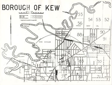
Plan, Borough of Kew, 1910
This work forms part of the collection assembled by the historian Dorothy Rogers, that was donated to the Kew Historical Society by her son John Rogers in 2015. The manuscripts, photographs, maps, and documents were sourced by her from both family and local collections or produced as references for her print publications. Many were directly used by Rogers in writing ‘Lovely Old Homes of Kew’ (1961) and 'A History of Kew' (1973), or the numerous articles on local history that she produced for suburban newspapers. Most of the photographs in the collection include detailed annotations in her hand. The overhead transparency is of a map produced by H.C. Crouch Borough Surveyor in 1910The Rogers Collection provides a comprehensive insight into the working habits of a historian in the 1960s and 1970s. Together it forms the largest privately-donated collection within the archives of the Kew Historical Society.An overhead transparency of a plan of Kew comparing the roads in 1860 with later roads constructed by 1910. Sections of the plan are marked with the location of particular buildings, farms or transport routes.Borough of Kewborough of kew, h.c. crouch -
University of Melbourne, Burnley Campus Archives
Plan, Alexander Metherell Pty. Ltd, Report on Existing Site Conditions at Victorian College of Agriculture and Horticulture Burnley, 1983
Report in plastic folder by Alexander Metherell Pty. Ltd., Melbourne dated November, 1983. Includes plans of Orchard and Campus. See B11.0716 and B11.0599 for descriptions of plans.alexander metherell, vcah, burnley -
 Bendigo Historical Society Inc.
Map - BENDIGO WEEROONA GASWORKS MAP/PLAN COLLECTION: LAY OUT OF NORTHERN SECTION, 1982
Plan of Bendigo Weeroona Works, works lay out northern section. Written on bottom of plan: this tracing from old drawing …. (?) difficult to read, very faded.plan, bendigo, bendigo weeroona gasworks, gas works -
 Melbourne Tram Museum
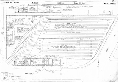
Drawing, Melbourne & Metropolitan Tramways Board (MMTB), "Kew Depot", c1938
Photocopied plans or drawings on A3 sheet of "Kew Depot 22/9/1938 P8400 - Plan of land and buildings - with some 1967 notes shows substation location.trams, tramways, drawings, depots, property, kew, substation -
 Bendigo Historical Society Inc.
Document - MARKS COLLECTION: ALTERATIONS TO FORTUNA VILLA FOR G. LANSELL
Copy of plan: Proposed alterations to Fortuna House (not Villa) for G. Lansell Esq. Plan shows stairway, building. Scale 1/4 inch - 1 foot.buildings, house, fortuna villa -
Port Melbourne Historical & Preservation Society
Plan, Bay Street, C. 1990
A proposed plan for the development of Bay Street, Port Melbourne. The Street plan shows suggestions for tree planting, verandah changes, proposed open space & building use.bay street, built environment - commercial -
 Bendigo Historical Society Inc.
Plan - MARKS COLLECTION: ALBERT PARK SERPENTINE HOUSE PLAN FOR H. LANSELL
Laminated plan showing house plan, side and front elevations, for house plan for H. Lansell, Serpentine. Hand coloured drawings and floor plan. Edwardian style shows large house with maid's quarters, cellar, dining room, bedrooms, dressing room. On top of plan written in black pen Proposed Homestead, Albert Park, Serpentine, for H. Lansell Esq, scale eight feet to one inch, W. Beebe & G.D. Garvin, architects, late W. Beebe, Mitchell Street, Bendigo..bendigo, house, albert park, serpentine -
 Ringwood and District Historical Society
Pamphlet, Subdivisional Auction Sale, Bedford Park, Ringwood - 1924
Bedford Park subdivisional development did not eventuate. The land adjoining the railway line became parkland with provision for sporting facilities and the remainder was purchased by the Education Department as the site for Ringwood High School/Secondary College. Double sided bifolded auction sale advertisement including subdivision features and local facilitiesSubdivision plan includes Bedford Road, Graham Road, Joyce Street, Anderson Street, and Adams Street