Showing 4563 items matching "the avenue"
-
 Bendigo Historical Society Inc.
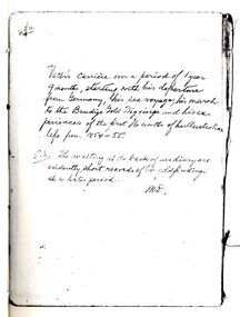
Book - STRAUCH COLLECTION: MEMOIRES OF A BENDIGO PIONEER- BOLDT DIARY
Albert Wilhelm August Boldt (1829-25/8/1895) was born in Strasbourg, Prussia. HE came to Australia and Bendigo in 1854 where he undertook mining. In 1860 he married Elise Marie Streiff.The following pages contain what is evidently the diary of Albert Wilhelm August Boldt, but it is not known who made the introductory comments and was very likely also the person who translated it into the English language. The original is in the hands of Richard Slade of 9 Phillips avenue Carnegie Vic 3163 and several copies were made with his permission in mid 1992.person, individual, albert wilhelm august boldt -
 Ringwood and District Historical Society
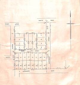
Card - Double-sided Display, Land Subdivision Map Samples
Side 1 - Layout of 20 residential allotments in Shasta Avenue, Merrilong Street, Northwood Street and Alexandra Road, Ringwood East, Victoria (Undated). Side 2 - Extract from Land Auction advertisement for sale of 23 allotments in Ridge Road, Oakley Street and Mount Dandenong Tourist Road, Mount Dandenong, Victoria - circa 1950s. -
 Phillip Island and District Historical Society Inc.
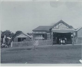
Photographs, 1940's
Store located in Thompson Avenue, Cowes where the Commonwealth Bank was located and now a Furniture Shop. On right hand side heading down the hill. Owned by Smith family (Jessie and husband). Purchased by Bernie & Nell Mulholland. Still there in the 1950's.348-01: Black & White photograph of the Cowes Motor Garage at left and Smiths Motor Garage and Tea Rooms on the right. Three children in the gateway in front of the Motor Garage and four people in front of the Tea Rooms. On the front of the Tea Rooms is printed " confectionery, home made cakes, iced drinks, photo materials and Kodak's developing printing". 348-02: Black & White photograph of the same store and garage taken at a different angle. No people in the photograph.smith motor garage & tea rooms, cowes motor garage, smith family, allan smith -
 Phillip Island and District Historical Society Inc.
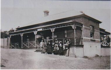
Photograph, Cowes Post Office, Phillip Island, 1920
Post Office on corner of Thompson Avenue and The Esplanade. Brick above concrete building with two brick chimneys. Iron roofing, fenced verandah. Group of 12 people, males suited, with collars and ties, ladies all in long skirts, jackets and hats.Post Office with group of people standing and seated in front of buildingP.O.Cowes (written on back of photograph)local history, photographs, post office, cowes, black & white photograph, ann brown collection, bruce bennett -
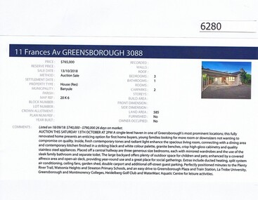 Greensborough Historical Society
Advertising Leaflet, Barry Plant Greensborough, 11 Frances Avenue Greensborough, 13/10/2018
Real estate advertisement for 11 Frances Avenue Greensborough, a 3 bedroom house. Originally listed with Barry Plant, this house was sold on 13/10/2018 by Jellis Craig for $765,000. Previous sales: March 2011 for $551,000; and November 1998 for $136,000. Real estate advertisement black text and colour photographfrances avenue greensborough -
 Port Melbourne Historical & Preservation Society
Flyer - Gretz Gallery Summer Arts Festival, A Community Invitation, c. 1990
Gretz was located at Ingles/Bay/Garton Streets and run by the Stuart family (Helen, Gerry, Claire, Kristin?) in the late 1980s, later moving to Victoria Avenue, Albert Park, with the girls using the vacated St Josephs Primary as studios through the 1990s.Pale green, A6 invitation to a Gretz Gallery Summer Arts Festival, 1 December c1990 - letterboxed to Port residentsarts and entertainment - visual arts, celebrations fetes and exhibitions, gretz gallery -
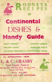 Ringwood and District Historical Society
Booklet, Grasby, L. and C, Rodney's Recipes of Continental dishes and Handy Guide. From Your local Butcher (L & C Grasby, 78 Railway Avenue, East Ringwood, WU 6003) c1960, c1960
Given to customers of L. and C. Grasby, Your Family Butcher, 78, Railway Avenue, East Ringwood.Roney's Recipes of Continental Dishes and handy Guide of party drinks, calorie chart, dietetic charts, sporting facts, cooking measures and temperature guide.10 page booklet plus cream coloured covers with red and green printing on both sides. Contains recipes for various occasions, drinks, charts, cooking measures and temperature guide. Given to customers of the butcher. Covering letter from Mrs. Ives +Additional Keywords: Grasby / Ives, Mrs. Norma. All the Ives family lived at 2 Lois Street, East Ringwood until moved away, except for the eldest Ted and his daughter Lynda who lived at 4 Lois Street. -
Glen Eira Historical Society
Article - ELSTER AVENUE, 16, ELSTERNWICK
This file contains 6 items: 1/Handwritten notes by Peta Darke dated 25/07/2014 listing title details for 16 Elster Avenue from 1909 to 2009 – two pages. 2/Handwritten list of Sands and McDougall entries for the property from 1915 to 1940 dated 25/07/2014 compiled by Peta Darke. 3/A photocopy of a Biggin Scott Real Estate Agents flyer advertising the recent sale of the property in 2009. 4/Print out from ‘The Argus’ of 04/12/1917, Page 6, from the Trove website of a brief article concerning the wounding of S.P.Jones, son of Stephen Jones of ‘Mons’, Elster Avenue in November 1917. 5/A photocopy of colour photograph of exterior of 16 Elster Avenue Circa 1998 taken by R.Darke. 6/Article from ‘Caulfield Glen Eira Leader’ of 25/03/2014, Page 3, concerning Oscar Jones, 14 year old son of present owners, who is an excellent surf life saver. Includes colour photograph of Oscar.elster avenue, college street, bowood, elsternwick, bowden arthur william, mons, hartington street, parnell street, jones stephen alma, kooyong road, kendall ann bell, kendall james william, kendall harold duncan, morrison harold lindsay, morrison rhonda may, cook jean isobel, golding ida curnow, perrett craig stuart, perrett eileen mary, perrett edward, perrett anthea, perrett catherine, lewis kay margaret, swain anthony barry gilles, swain darcy, swain mitchell, jones adrian, jones karine stehman, jones oscar, jones patrick, thomas lloyd, rickman jacob, lee james t, nidschelm harold, regan francis, jones douglas, laughton martin, biggin and scott, ashton daniel, jones stephen percy douglas, architectural styles, edwardian style, timber houses, gardenvale, collinson william morris, thomson william hamilton, lempriere john thompson -
 Federation University Historical Collection
Book, Back to Bacchus Marsh, 1957, 1957
A back to Bacchus Marsh was held from 12 to 20 October 1957.Brown covered book of 28 pages including the official programme for back to Bacchus Marsh, 1957. The book includes an historical essay, Maddingley Brown Coal, World war 11, Darley Military Camp, Darley Firebrick Co., industrial changes and numerous advertisements. Images include: * Grant Street Avenue *St Bernard's new Parish Hall and Schoolrooms * Maddingley No. 2 Cut * Terracing at Maddingley - part of the beautification scheme at Maddingley * Hospital entrance with War memorial Feature * Old Woolpack Inn * Jim Pyke * Infant Welfare and pre-School Centre, Young St * Bacchus Marsh Main Street looking East, 1872 * Andrew George Scott, alias Captain Moonlight * Grant Street Avenue * Ballarat State School No 28 featuring the World War One Memorial Clock maddingley brown coal, world war 11, old woolpack inn, darley military camp, darley firebrick, jim pyke, andrew george scott, captain moonlite, bacchus marsh, world war, bacchus marsh state school no 28, grant street avenue, bacchus marsh war memorial hospital, bacchus marsh avenue of honour, captain bacchus -
 Kew Historical Society Inc
Plan, Melbourne & Metropolitan Board of Works : Borough of Kew : Detail Plan No.1592, 1905
The Melbourne and Metropolitan Board of Works (MMBW) plans were produced from the 1890s to the 1950s. They were crucial to the design and development of Melbourne's sewerage and drainage system. The plans, at a scale of 40 feet to 1 inch (1:480), provide a detailed historical record of Melbourne streetscapes and environmental features. Each plan covers one or two street blocks (roughly six streets), showing details of buildings, including garden layouts and ownership boundaries, and features such as laneways, drains, bridges, parks, municipal boundaries and other prominent landmarks as they existed at the time each plan was produced. (Source: State Library of Victoria). This plan forms part of a large group of MMBW plans and maps that was donated to the Society by the Mr Poulter, City Engineer of the City of Kew in 1989. Within this collection, thirty-five hand-coloured plans, backed with linen, are of statewide significance as they include annotations that provide details of construction materials used in buildings in the first decade of the 20th century as well as additional information about land ownership and usage. The copies in the Public Record Office Victoria and the State Library of Victoria are monochrome versions which do not denote building materials so that the maps in this collection are invaluable and unique tools for researchers and heritage consultants. A number of the plans are not held in the collection of the State Library of Victoria so they have the additional attribute of rarity.Original survey plan, issued by the MMBW to a contractor with responsibility for constructing sewers in the area identified on the plan within the Borough of Kew. The plan was at some stage hand-coloured, possibly by the contractor, but more likely by officers working in the Engineering Department of the Borough and later Town, then City of Kew. The hand-coloured sections of buildings on the plan were used to denote masonry or brick constructions (pink), weatherboard constructions (yellow), and public buildings (grey). In MMBW Plan No.1592, the pink line indicates that area of the plan for which the contracting engineer was responsible. Included in the Plan are a number of primarily brick villas in a section of Belmont Avenue off Cotham Road. The house ‘Uvadale’ north of Belmont Avenue, and facing Cotham Road is also included in the contract. Excluded from the contract but shown on the Plan are ‘Glendonald’, ‘Mont Belmont’ and ‘Gilden’.melbourne and metropolitan board of works, detail plans, survey plans - borough of kew, mmbw 1592, cartography -
City of Kingston
Photograph - Colour, Circa 1993
Edithvale is a suburb in the City of Kingston. It is located between Aspendale and Chelsea on the Port Phillip Bay and built within remnant areas of the Carrum Carrum swamp. The foreshore precinct comprises a wide sandy beach, with low sand dunes and numerous historic boat sheds. The suburb consists of older style dwellings and former holiday houses, combined with mid-century housing and newer homes. The large blocks are increasingly subdivided and the existing dwellings demolished to accommodate units and townhouses, thus changing the landscape of the area and reducing the tree canopy.The beachside suburb of Edithvale was previously part of the extensive Carrum Carrum Swamp. The area was once a source of fish and eels for the Mayone-Bulluk clan of the Bunurong people. Over time the area was drained and predominantly devoted to dairy farming and holiday houses. The farms were gradually sold and subdivided with a large number of homes built after World War II and in the 1960s. Edithvale is mainly residential with a shopping strip along Nepean Highway but little significant industry was ever established in the area apart from a plaster works and confectionary factory, both now closed.Aerial colour photograph of Edithvale as viewed from Alexandra Avenue in the north to Ella Grove Chelsea/Edithvale in the south. The area is built-up with residential housing and facilities including Edithvale Primary School, numerous churches and the Edithvale Railway station. Large sections depict the remnant Carrum Carrum swamp. Edithvale Common and the former "Duck Inn" (Melbourne Water/Friends of Edithvale Seaford Wetlands) can be seen. Edithvale Recreational reserve, the velodrome and Edithvale Public Golf Course are prominent. The image shows vacant land in the area now known as Aspendale Gardens and the newer residential section of Chelsea Heights is not developed. A bike path has been established to cover the secondary drain. The Golf Links Court residential development located off Hughes Avenue is a large vacant block.Yellow circular adhesive sticker on plastic Black ink (marker): * (asterisk) Black type on white adhesive sticker: P000108edithvale, aspendale, chelsea, carrum carrum swamp -
 Greensborough Historical Society
Photograph, Unknown, Studleys of Scotland Avenue, 1920c
G.H. Studley [probably] and two children at 11 Scotland Avenue Greensborough. G. H. Studley was the son of Mr. G. Studley [it is supposed] who was Shire President of Heidelberg and prominent citizen in the 1860-1880s. Studley Road in Heidelberg is named after him.Copy of Black and white photograph in mount.studley, scotland avenue -
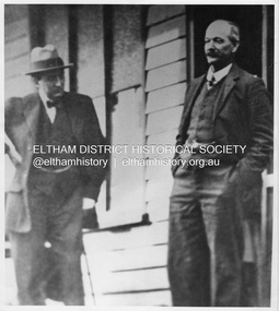 Eltham District Historical Society Inc
Photograph, Allwood, Hurstbridge - W.G. Gray and Capt. Bruce (later Lord Bruce), 1900
Captain Stanley Bruce, M.H.R. with Shire of Eltham Councillor William George Gray owner and manager of Allwood Nurseries at Allwood, Hurstbridge. They met on the occasion of the planting of trees to form the Anzac Avenue (of honour). Bruce would become Prime Minister of Australia in 1923. This photo forms part of a collection of photographs gathered by the Shire of Eltham for their centenary project book, "Pioneers and Painters: 100 years of the Shire of Eltham" by Alan Marshall (1971). The collection of over 500 images is held in partnership between Eltham District Historical Society and Yarra Plenty Regional Library (Eltham Library) and is now formally known as 'The Shire of Eltham Pioneers Photograph Collection.' It is significant in being the first community sourced collection representing the places and people of the Shire's first one hundred years.Digital imagesepp, shire of eltham pioneers photograph collection, hurstbridge, w.g. gray, capt. bruce, stanely bruce -
 Greensborough Historical Society
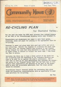
Newsletter, Greenhills and North Greensborough Progress Association, Community News: official journal of the Greenhills and Nth. Greensborough Progress Association. 27th June, 1973. Edition No. 5/73, 27/06/1973
This edition includes a report on the Progress Association's June 1973 meeting, Councillor's report, Re-cycling Plan for Diamond Valley, Diamond Valley Repertory, Eltham Film Society, School and Kinder news, The Plenty River: Fricker Avenue Reserve, Open forum,.Newsletter, 24 p., illus.greenhills and north greensborough progress association, greenhills -
Box Hill Historical Society
Photograph - View of Strabane Chapel, 1/12/1994
View of Strabane Chapel at 29 Strabane Avenue, Box Hill North, home of U3A (University of the Third Age). It was once St Joseph's Church. Architect was Peter Corrigan who received an architectural award for the design. The building is now listed with the National Trust.churches, halls, strabane chapel, university of the third age, u3a, adult education, st. joseph's church, strabane avenue, box hill north -
 Bendigo Military Museum
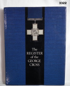
Book - BOOK, GEORGE CROSS, The Register of the George Cross, 1985
Hard cover, dark blue buckram. Gold print front & spine. Dust cover dark blue striped background with the George Cross with ribbon over black band in foreground. Rear view of George Cross on back section of dust cover. 151 pages, cut, plain, white. Illustrated, black & white photos, portraits of recipients.On front fly leaf handwritten inscription & two RSL stamps: "M R Birks 3 Timbertop Avenue Carlingford NSW, 2118 Australia" Handwritten in black ink on front fly leaf: "To Ray Birks from Leon Goldsworthy" books - reference, military history - army, george cross -
 Ringwood and District Historical Society
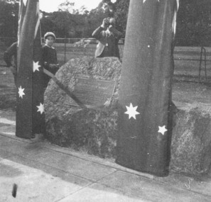
Photograph, Unveiling of plaque in memory of Edward George Honey. 1962
Collection of ten black and white photographs on one sheet.Written on back of collection: "Unveiling plaque in memory of Edward Honey who suggested the '2 minutes silence', Armistice Day. Elderly lady- Mrs Honey lived in Heathmont." Plaque now in Birdwood Avenue, near the Shrine of Remembrance, Melbourne. -
 Kew Historical Society Inc
Plan, Melbourne & Metropolitan Board of Works / Borough of Kew, Detail Plan No.1593, 1905
The Melbourne and Metropolitan Board of Works (MMBW) plans were produced from the 1890s to the 1950s. They were crucial to the design and development of Melbourne's sewerage and drainage system. The plans, at a scale of 40 feet to 1 inch (1:480), provide a detailed historical record of Melbourne streetscapes and environmental features. Each plan covers one or two street blocks (roughly six streets), showing details of buildings, including garden layouts and ownership boundaries, and features such as laneways, drains, bridges, parks, municipal boundaries and other prominent landmarks as they existed at the time each plan was produced. (Source: State Library of Victoria)This plan forms part of a large group of MMBW plans and maps that was donated to the Society by the Mr Poulter, City Engineer of the City of Kew in 1989. Within this collection, thirty-five hand-coloured plans, backed with linen, are of statewide significance as they include annotations that provide details of construction materials used in buildings in the first decade of the 20th century as well as additional information about land ownership and usage. The copies in the Public Record Office Victoria and the State Library of Victoria are monochrome versions which do not denote building materials so that the maps in this collection are invaluable and unique tools for researchers and heritage consultants. A number of the plans are not held in the collection of the State Library of Victoria so they have the additional attribute of rarity.Original survey plan, issued by the MMBW to a contractor with responsibility for constructing sewers in the area identified on the plan within the Borough of Kew. The plan was at some stage hand-coloured, possibly by the contractor, but more likely by officers working in the Engineering Department of the Borough and later Town, then City of Kew. The hand-coloured sections of buildings on the plan were used to denote masonry or brick constructions (pink), weatherboard constructions (yellow), and public buildings (grey). The laborious task of hand-tinting these Board of Works plans was not without hazards as is evidenced by Plan No. 1593. On the Plan, the original colourist spilt black and green ink, partially obscuring some parts. The most obvious casualty is ‘Clifton’ located on the corner of Cotham Road and Park Street [now Adeney Avenue]. Included in this Plan, and outlined in pink is that part of the section that the contracting engineer was tasked with completing. This included sewering on both sides of this part of Cotham Road, but excluded properties such as ‘Glendonald’ and ‘Monnington’. This area was to undergo a series of subdivisions including the ‘Clifton Estate’, which created housing lots on Adeney Avenue and Florence Avenue in 1916. The most notable occupant of Clifton was William Adeney [died 1893], a pioneer of Camperdown, after which Park Street was later renamed.melbourne and metropolitan board of works, detail plans, survey plans - borough of kew, mmbw 1593, cartography -
 Greensborough Historical Society
Map, Melbourne and Metropolitan Board of Works. Survey Division, MMBW, Yarra 2500 / 17.27. Central Hurstbridge, 1978_02
Melbourne and Metropolitan Board of Works. Yarra 2500 [base map] 17-27. Central Hurstbridge. Parish of Greensborough 2724, Municipalities of Diamond Valley 257, Eltham 238 and Whittlesea 239. Prominent streets include: Anzac Avenue and Hurstbridge-Arthurs Creek Road. MMBW Map in 1:2500 [scale] series. Cream parchment with green tape reinforcing on edges and punched holes on left edge.mmbw, melbourne and metropolitan board of works, shire of diamond valley, hurstbridge - maps -
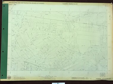 Greensborough Historical Society
Map, Melbourne and Metropolitan Board of Works. Survey Division, MMBW, Yarra 2500 / 14.20. Montmorency, Sherbourne Road, 1977_06
Melbourne and Metropolitan Board of Works. Yarra 2500 [base map] 14.20. Montmorency, Sherbourne Road. Municipality of Diamond Valley 257 and Eltham 238. Prominent streets: Sherbourne Road, Karingal Drive and Calrossie Avenue. Features include Montmorency Station and Meruka Park.MMBW Map in 1:2500 [scale] series. Cream parchment with green tape reinforcing on edges and punched holes on left edge.mmbw, melbourne and metropolitan board of works, shire of diamond valley, montmorency - maps -
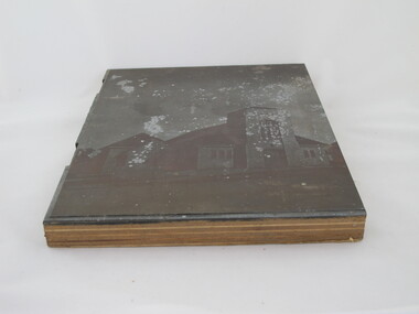 Uniting Church Archives - Synod of Victoria
Photographic print block
Glen Iris Presbyterian Church on the corners of High Street and Allison Avenue. The foundation stone was laid by Prime Minister Mr R. G. Menzies and was opened on 21 November 1953. This photograph is on page 1 of the publication "Glen Iris Presbyterian Church Jubliee History".Outside view of Glen Iris Presbyterian Church.On back "Glen Iris Presbyterian"glen iris presbyterian church -
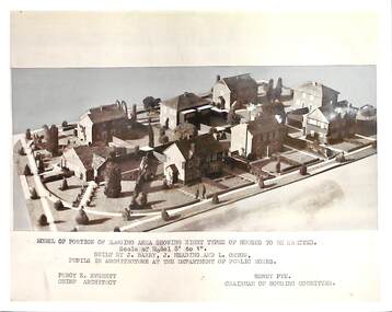 Port Melbourne Historical & Preservation Society
Photograph - Dunstan Estate during construction, Port Melbourne, Department of Public Works, 1936
Twenty five (25) black and white or sepia photographs of the houses of the Dunstan Estate during their building i.e. Griffin Crescent and Southwood Avenue .16 - .25 - photographs of models made by pupils of Architecture at the Department of Public Works . Shows eight types of houses to be erected. Chief Architect Percy E Everett and Henry Pye the Chairman of the Housing Committee built environment - domestic, domestic life, department of public works, dunstan estate, percy e everett, henry pye, albert dunstan -
Port Melbourne Historical & Preservation Society
Document - Family History, Graeme SCOBLE, 1964 - 2018
(a) musical history Spiral bound copy listing all of musical organist Graeme Scoble's musical history. Dates, places, churches, emgagements. (b) photocopies of family photographs (c) part of "The Record" Saturday February 29, 1964. An article on Graeme SCOBLE, from Page Avenue, being appointed as assistant Musical Director for Port Melbourne Meistersingersfamilies, page avenue, graeme scoble, ian scoble, ronald scoble, frederick arthur scoble, percey scoble, keith scoble, joan susan scoble -
Whitehorse Historical Society Inc.
Document, Zander Avenue, 7/01/1986
Memories by Merle Duncan recorded 7/1/1986. Zander Avenue named after the Zanders who had an apple orchard there. Wright Family owned a milk bar in Springfield Road and they built Mountain view shops in Springfield Road. The old manse, now the Nunawading North Community House was their home. Nicoll Reserve was a pear orchard owned by the Aytons.roads and streets, zander avenue, nunawading, nunawading, duncan, merle, wright family, mountain view shops, springfield road, nunawading, nicoll reserve, ayton family, zander family -
 Southern Sherbrooke Historical Society Inc.
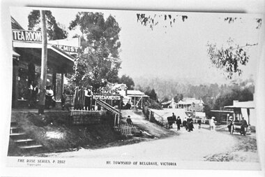
Photograph - Main Street, Belgrave
Township of Belgrave from Rose Series P. 2952. Photograph taken from the low side looking towards Mount Dickie and the Terrys Avenue intersection. A group is walking past the tea rooms, as a man stands near the top of the stairs to the road. A young boy stands at the bottom. People are walking along the road. A horse and cart and a car can be seen. -
![Escol Estate [Kew], 1940](/media/collectors/550653872162f11fb04854aa/items/59115843d0ce2b1f048f0fbb/item-media/591158fdd0ce2e1f04f1e0f5/item-fit-380x285.jpg) Kew Historical Society Inc
Kew Historical Society IncPlan - Subdivision Plan, Escol Estate [Kew], 1940, 1940
Pru Sanderson, in her groundbreaking ‘City of Kew Urban Conservation Study : Volume 2 - Development History’ (1988), summarised the periods of urban development and subdivisions of land in Kew. The periods that she identified included 1845-1880, 1880-1893, 1893-1921, 1921-1933, 1933-1943, and Post-War Development. These periods were selected as they represented periods of rapid growth or decline in urban development. An obvious starting point for Sanderson’s groupings involved population growth and the associated economic cycles. These cycles also highlighted urban expansion onto land that was predominantly rural, although in other cases it represented the decline and breakup of large estates. A number of the plans in the Kew Historical Society’s collection can also be found in other collections, such as those of the State Library of Victoria and the Boroondara Library Service. A number are however unique to the collection.The Kew Historical Society collection includes almost 100 subdivision plans pertaining to suburbs of the City of Melbourne. Most of these are of Kew, Kew East or Studley Park, although a smaller number are plans of Camberwell, Deepdene, Balwyn and Hawthorn. It is believed that the majority of the plans were gifted to the Society by persons connected with the real estate firm - J. R. Mathers and McMillan, 136 Cotham Road, Kew. The Plans in the collection are rarely in pristine form, being working plans on which the agent would write notes and record lots sold and the prices of these. The subdivision plans are historically significant examples of the growth of urban Melbourne from the beginning of the 20th Century up until the 1980s. A number of the plans are double-sided and often include a photograph on the reverse. A number of the latter are by noted photographers such as J.E. Barnes.The ‘Escol Estate’ was a subdivision, which created Bramley Court, which runs south from Sackville Street between Evans Road and Orford Avenue. The subdivision was comprised of 12 lots. At the auction of the lots in May 1940, eight of the 12 allotments were sold. The land was sold subject to a restriction of only one private residence being erected on each lot.subdivision plans - kew, sackville street – kew (vic.), bramley court – kew (vic.) -
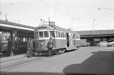 Melbourne Tram Museum
Negative, Travis Jeffrey, 30/09/1961 12:00:00 AM
Negative of trams 557 and 849 at Batman Avenue tram terminus. Tram 557 in foreground has destination Wattle Park - Elgar Rd and Route No 70. Photo shows tram on the right track (outwards from city), with driver and conductor standing in front of tram, posing for the camera. Tram 849 in background has destination Prahran (route not visible).Paper folder that contained the negative had "NR58A" written in red ink, "M3" written in pencil, "48A" written in blue ink, and date stamped/written as 30 Sep 1961.trams, tramways, w2 class, sw5 class, route 70, batman ave, wattle park, prahran, crews, conductors, tram 557, tram 849 -
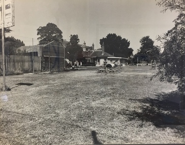 Kew Historical Society Inc
Photograph - 'Carronbank', Marshall Avenue, 1980s
Carronbank (demolished) in Marshall Avenue, Kew was once the home of the Rev Graham Henty Balfour. It had extensive grounds, including a tennis court at the rear of the property. It remained a private residence until c.1960. The Department of Education purchased Carronbank as a school for partially sighted children, opening in February 1961 as State School No 4483. During the period 1961 to c.1980, the building housed a number of services. From 1969 to 1974, it was the site of Carronbank State School, later renamed Carronbank School for Deaf-Blind Children. In 1973, the Department established the Visiting Teacher Service for the Visually Impaired at the site. Its aim was to support teachers working in Victorian Government, Catholic and Independent Schools. From 1983 the school operated as Statewide Resource Centre for Visiting Teachers of the Vision Impaired. In 1988, the amalgamation of Princess Elizabeth Junior School for Deaf Children, the Monnington Centre and Carronbank School for Deaf Blind Students allowed the Victorian Government to sell each of the sites. Monnington [Adeney Avenue, Kew] reverted to private ownership, while Glendonald and Carronbank in Marshall Avenue were demolished and subdivided.The donor, Mr Murray Osler, was Principal of the Monnington Special Education Centre in Adeney Avenue (Kew) from 1976. This photo, and an accompanying drawing of 'Monnington' are important primary resources for the delivery of education to and for deaf-blind children in Victoria.The photograph, framed under perspex, shows the tennis court of Carronbank which had been converted into a play area for the students of the school. The flat roofed building may have been a toilet block, added for the school. The garage brick wall belongs to No 11. Grass is growing on the original asphalt court and there is equipment and tunnels for play. When sold the property was divided into three separate building blocks.carronbank -- marshall avenue -- kew (vic.), schools -- kew (vic.), carronbank -
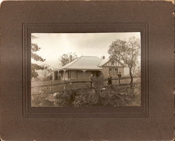
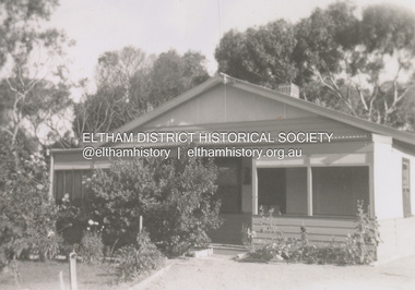 Eltham District Historical Society Inc
Photograph, Glenair, 9 Minifie Avenue, Anglesea, c.1950
John Ingram, baker of Research and his wife Ada (nee Key) owned a holiday house (Glenair) at 9 Minifie Avenue, Anglesea. At some time between 1943 and 1949 they relocated permanently to Anglesea. Ada was an artist. View of rear of house from back garden.anglesea, pam thoonen (nee ingram) collection, 9 minifie avenue, glenair, house -
Glen Eira Historical Society
Document - Linlithgow Ave, 4 Caulfield North
A heritage study from the City of Glen Eira Heritage Management Plan by Andrew Ward, 1996 on Linlithgow, 4 Linlithgow Avenue, Caulfield North. Report details the building’s significance, history and exterior and interior features. Includes references and a photocopied black and white photograph of the exterior.linlithgow, linlithgow avenue, linlithgow co-ed college, caulfield north, ward andrew, streamline moderne, art deco, duncan william, melbourne jockeys premiership, melbourne cup, slaney h, glen eira road, wood samuel, wood muriel, bambra road, jackson archibald, golding elizabeth, inkerman hotel, stables, horse racing, horse training, city of glen eira heritage management plan, haase eva nm, favelle bessie bain, favelle jack joseph, architectural styles, architectural features