Showing 17386 items matching "up"
-
 Kiewa Valley Historical Society
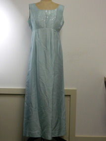
Dress - Aqua Silk, c 1960's
This dress was typical of those worn on 'after 5' special occasions to: dinner dances, weddings, balls. There were many such functions at Mt Beauty and the Kiewa Valley eg. the Hospital Ball.This dress was worn (and possibly made) by Margaret Mc Kendrick (nee Vyner) who lived in Tawonga when growing up. She married Ian Mc Kendrick and they lived in Mt Beauty. She worked as a nurse at the Tawonga & District hospital. Ian worked at the Mt Beauty Post Office. They had 3 children.Aqua silk long (full length) sleeveless dress. Sequined with beads individually hand sewn. Princess line. Zip full length at the back. A couple of pleats at the front and back. 'A' line skirt. Accompanied by a guipure lace short jacket with three quarter sleeves, lined with the same silk as the dress. Scalloped at the bottom of the jacket. Covered button at the top of the back with a loop.'after 5' dress; margaret mckendrick; tawonga; ladies' clothing -
 Kiewa Valley Historical Society
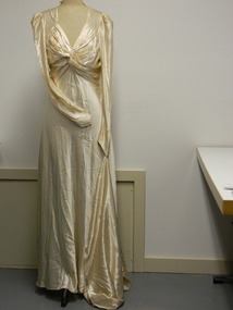
Dress - Wedding Ivory Satin
This dress was worn by Margaret Vyner on her wedding day to Ian Mc Kendrick. Margaret's mother's name was Rita. Margaret was living with her family at Tawonga, Ian was living at Mt Beauty.The couple were locals of the Kiewa Valley. Ian worked at the Mt Beauty Post Office and Margaret at the Tawonga & District Hospital. Their 3 children grew up in Mt Beauty.Ivory / off white satin wedding dress with a train at the back. Puffed with stiffening & padded long sleeves which come to a point at the wrist where fastened with a press stud. Ruched cross over bodice with a V neckline with a semi circular skirt. Plain back to the waist and a half self belt fastened at the back by 3 covered buttons and 3 loops. Left side as a plaquet fastened by 2 hooks and eyes. Semi circular skirt which has, at the rear, a 100 cm train with a finger loop.wedding dress; margaret vyner (mckendrick); tawonga; ladies' clothing -
 Kiewa Valley Historical Society
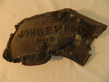
Roper's Hut Memorabilia
Roper's Hut was built in 1939 and was burnt down in 2003. It was rebuilt in 2008 and is situated on the Bogong High Plains on Duane Spur (where Duane's hut had been before it too was destroyed by (1939) bushfires, between Mt Nelse and Big River. The original hut was used as a shelter for cattlemen who grazed their cattle on the High Plains during summer. The Victorian High Country Huts Association Inc. members and friends helped rebuild the hut which is now used as an emergency shelter for visitors to the High Plains.The memorabilia is significant as the items belonged to the Roper family who were one of the original settlers of the Kiewa Valley and one of the original families who drove their cattle up to the Bogong High Plains. The burnt plaque and forks and the rebuilding of the huts (Duane's & Roper's) are significant as bush fires are a constant threat to the Bogong High Plains destroying large areas at a time.1. Bronze Plaque and 2 damaged forks from Roper's Hut which was destroyed by bush fires in 2003. 2. DVD & USB and hard copy photos of the rebuild of Roper's Hut in January 2008.The plaque had 'In Memory of / John F. P. Roper/ died 3-12-1977 / Aged 78 years / He built the original hut Feb. 1939'roper's hut, cattlemen, bogong high plains, bronze plaque, roper family, bush fires -
 Kiewa Valley Historical Society
Papers - Jim Goonan's Story - Dederang, 1950's
Early settlers came to Dederang from Kergunyah. The main road, Dederang to Tawonga was opened about 1860 - 1864, connecting 'Crosthwaite's Gap' with 'Smith's corner'. Jim Goonan's ancestors selected land between Dederang and Tawonga in the early 1860's.A comprehensive history of the town of Dederang from the 1860's up to the 1950's. Early settlers, infrastructure, businesses, activities including sport and life style are described giving an insight into how the Kiewa Valley developed during this time.26 typed pages of the History of Dederang. Each page consists of paragraphs with a heading.dederang, jim goonan, kiewa valley -
 Kiewa Valley Historical Society
Photograph - Folder of Photographs (KVHS 1150 A - F) – Photocopied set of black and white photographs from the display folder (pages 1 - 8) put together by KVHS to document life on the Kiewa Valley Hydro-electric Scheme
Although the Kiewa Hydro-Electric Scheme was first proposed in 1911, construction did not commence until 1938. As part of the push to cut electricity costs and diversify supply, the Victorian Government (circa 1930) initiated the conversion from primarily brown coal supply to hydro – electricity. Field investigations during the 1940’s resulted in a new proposal for a scheme that had more than double the capacity of the 1938 scheme. The Kiewa Hydroelectric Scheme became the largest scheme of its kind in the State Of Victoria and the second largest scheme in Australia. The number of personnel involved in the planning and construction of the scheme increased dramatically. During the late 1940’s, most activity centred around the construction of the West Kiewa Power Station, Rocky Valley Reservoir, McKay Creek Power Station and the Bogong Creek Aqueduct.A common thread across all the larger hydro scheme constructions was the need for workers, both qualified and unqualified who came from around the world seeking a new life for themselves and their families. New accommodation and facilities were required for the army of workers engaged in construction in often remote and wild areas. The SEC had a high demand for timber, and set up the first of a number of sawmills at Bogong Creek in 1939 and set up the first hardwood logging in the headwaters of the Kiewa River. These new ‘towns’ such as Mt Beauty and Bogong, survived, serving the needs of operational personnel and their families, and expanding with growth of new industries. Mount Beauty, and to a lesser extent Bogong, are among these places. Large A3 size spiral bound display folder containing 21 of 58 pages of photocopied black and white photographs of various aspects of the early days of the Kiewa Valley Hydro-electric scheme including equipment, various work sites and photographs of workers and their families. 1-Front page; 2-Security gate at Mt Beauty Camp; 3-Channel 1 on East Kiewa River; 4-Junction Dam – Diversion Tunnel Inlet; 5-Sawmill; 6- Homan’s Gap Sawmill; 7 Junction Dam: 8-Homan Dam Site-Diamond Drilling on River Buttress; 9- Homan Dam Site View Upstream 10-Homan Dam Investigation Camp 1-Windsor & Newton Visual Diary 60 sheet (120 pages) 11’ x 14’ 280 x 356mm 110 GSM Acid Free Drawing Paper 2-1940-Security Gate on Mt Beauty side of Kiewa River bridge. Part of old Mt Beauty camp and mess in background 3- STATE ELECTRICITY COMMISSION OF VICTORIA Date; 11.3.40 Time: 10.30am No K35 Kiewa Hydro Electric Works. Diverting East Kiewa River into Channel Page number 1 4-STATE ELECTRICITY COMMISSION OF VICTORIA Date: 5.4.40 Time: Noon No K58 Kiewa Hydro Electric Works. Junction Dam – Diversion Tunnel Inlet – Normal Flow Page number 2 5- STATE ELECTRICITY COMMISSION OF VICTORIA Date: 19.8.42 Time: 2.30pm No K883 Kiewa Hydro Electric Works. Sawmill – General View Page number 3 6- STATE ELECTRICITY COMMISSION OF VICTORIA Date: 12.1.42 Time: 2.00pm No K540 Kiewa Hydro Electric Works. Homan’s Gap Sawmill – General View Page number 4 7- STATE ELECTRICITY COMMISSION OF VICTORIA Date: 12.1.42 Time: 2.00pm No K540 Kiewa Hydro Electric Works. Junction Dam – General View looking upstream Page number 5 8- STATE ELECTRICITY COMMISSION OF VICTORIA Date: 16.11.45 Time: 10.32amm No K52153 Kiewa Hydro Electric Works Homan Dam Site – Diamond Drilling on River Buttress Page number 6 9-STATE ELECTRICITY COMMISSION OF VICTORIA Date: 15.1.45 Time: 4.10pm No K1781 Kiewa Hydro Electric Works Homan Dam Site – View Upstream Page number 7 10- STATE ELECTRICITY COMMISSION OF VICTORIA Date: 15.1.45 Time: 4.10pm No K1781 Kiewa Hydro Electric Works Homan Dam Investigation Camp 1944 – 1945 Page number 8 secv; kiewa hydro electric scheme; mt beauty; bogong; construction work; -
 Kiewa Valley Historical Society
Photograph - Folder of Photographs – Photocopied set of 10 black and white photographs (pages 19 - 28) from the display folder put together by KVHS to document life on the Kiewa Valley Hydro-electric Scheme
Although the Kiewa Hydro-Electric Scheme was first proposed in 1911, construction did not commence until 1938. As part of the push to cut electricity costs and diversify supply, the Victorian Government (circa 1930) initiated the conversion from primarily brown coal supply to hydro – electricity. Field investigations during the 1940’s resulted in a new proposal for a scheme that had more than double the capacity of the 1938 scheme. The Kiewa Hydroelectric Scheme became the largest scheme of its kind in the State Of Victoria and the second largest scheme in Australia. The number of personnel involved in the planning and construction of the scheme increased dramatically. During the late 1940’s, most activity centred around the construction of the West Kiewa Power Station, Rocky Valley Reservoir, McKay Creek Power Station and the Bogong Creek Aqueduct.A common thread across all the larger hydro scheme constructions was the need for workers, both qualified and unqualified who came from around the world seeking a new life for themselves and their families. New accommodation and facilities were required for the army of workers engaged in construction in often remote and wild areas. The SEC had a high demand for timber, and set up the first of a number of sawmills at Bogong Creek in 1939 and set up the first hardwood logging in the headwaters of the Kiewa River. These new ‘towns’ such as Mt Beauty and Bogong, survived, serving the needs of operational personnel and their families, and expanding with growth of new industries. Mount Beauty, and to a lesser extent Bogong, are among these places. Large A3 size spiral bound display folder containing 21 pages of photocopied black and white photographs of various aspects of the early days of the Kiewa Valley Hydro-electric scheme including equipment, various work sites and photographs of workers and their families. 1-Allis Chalmers Tractor School 2- Gardens outside Administrative Office – Mt Beauty 3- Mt Beauty house – 1950 4-Bridge over Pretty Valley River, Bogong 5-Rocky Valley Spillway Tunnel break through 6-Ni 1 Headrace Tunnel drilling face 7-No 4 Power Station Drilling 8-Clover Dam Flood Waters 9-No1 Head Race Tunnel Portal Building 10-Clover Dam 1-STATE ELECTRICITY COMMISSION OF VICTORIA Date: 5.9.49 Time: 10amm No K5174 Kiewa Hydro Electric Works Allis Chalmers Tractor School Page number 19 2-STATE ELECTRICITY COMMISSION OF VICTORIA Date: 22.2.50 Time: 3.30pm No K5601 Kiewa Hydro Electric Works Gardens outside Administrative Office – Mt Beauty Page number 20 3-Mt Beauty house – 1950 Page number 21 4-STATE ELECTRICITY COMMISSION OF VICTORIA Date: 23.10.50 Time: 11.15am No K6331 Kiewa Hydro Electric Works Bogong-Bridge over Pretty Valley River Page number 22 5-STATE ELECTRICITY COMMISSION OF VICTORIA Date: 23.6.50 Time: 2.30pm No K5844 Kiewa Hydro Electric Works ROCKY VALLEY SPILLWAY TUNNEL BREAK THROUGH Page number 23 6-20/3/52 – No. 1 Headrace Tunnel Drilling face (E.E.E. contract) Page number 24 7-6/6/52 – No 4 Power Station – Drilling Page number 25 8-STATE ELECTRICITY COMMISSION OF VICTORIA Date: 6/6/52 Time: No K7113 Kiewa Hydro Electric Works Clover Dam Flood Waters Page number 26 9-STATE ELECTRICITY COMMISSION OF VICTORIA Date: Oct 1952 Time: No K7239 Kiewa Hydro Electric Works No. 1 HEAD RACE TUNNEL PORTAL BUILDING. Handwritten underneath – This information from Ron White-the later Principal Hydro Engineer of the SEC. Oct 1952 Location incorrect? All work on No 1 had ceased after financial crash of 1951. This photo would refer to No 4 Headrace Tunnel? Page number 27 10-STATE ELECTRICITY COMMISSION OF VICTORIA Date: Jan 1953 Time: No K7307 Kiewa Hydro Electric Works CLOVER DAM Page number 28 secv; kiewa hydro electric scheme; bogong; mt beauty; construction area -
 Kiewa Valley Historical Society
Photograph - Folder of Photographs – Photocopied set of 10 black and white photographs (pages 29 - 38) from the display folder put together by KVHS to document life on the Kiewa Valley Hydro-electric Scheme
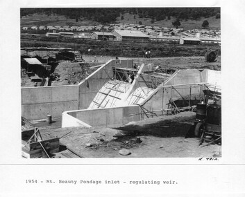
Although the Kiewa Hydro-Electric Scheme was first proposed in 1911, construction did not commence until 1938. As part of the push to cut electricity costs and diversify supply, the Victorian Government (circa 1930) initiated the conversion from primarily brown coal supply to hydro – electricity. Field investigations during the 1940’s resulted in a new proposal for a scheme that had more than double the capacity of the 1938 scheme. The Kiewa Hydroelectric Scheme became the largest scheme of its kind in the State Of Victoria and the second largest scheme in Australia. The number of personnel involved in the planning and construction of the scheme increased dramatically. During the late 1940’s, most activity centred around the construction of the West Kiewa Power Station, Rocky Valley Reservoir, McKay Creek Power Station and the Bogong Creek Aqueduct.A common thread across all the larger hydro scheme constructions was the need for workers, both qualified and unqualified who came from around the world seeking a new life for themselves and their families. New accommodation and facilities were required for the army of workers engaged in construction in often remote and wild areas. The SEC had a high demand for timber, and set up the first of a number of sawmills at Bogong Creek in 1939 and set up the first hardwood logging in the headwaters of the Kiewa River. These new ‘towns’ such as Mt Beauty and Bogong, survived, serving the needs of operational personnel and their families, and expanding with growth of new industries. Mount Beauty, and to a lesser extent Bogong, are among these places. Large A3 size spiral bound display folder containing 21 pages of photocopied black and white photographs of various aspects of the early days of the Kiewa Valley Hydro-electric scheme including equipment, various work sites and photographs of workers and their families. 1-Mt Beauty Pondage inlet-Regulating weir 2-Langfords Gap Basalt Hill-Tunnel in quarry face.3-Rocky Valley Camp-from Engineering Office 4-Basalt Hill tunnel portal 5-No 1 Pressure Shaft Works Bench 6-No 1 Power Station 7-Overturned haulage wagons on the side of an embankment 8- Group of workers dressed in wet weather gear inside a tunnel 9-Workmen and vehicle in tunnel 10-Howman’s Gap campsite at 4,150 feet 1-1954 – Mt Beauty Pondage inlet – Regulating weir Page number 29 2-28/10/54 – Langfords Gap Basalt Hill – Tunnel in quarry face K7860 Page number 30 3-STATE ELECTRICITY COMMISSION OF VICTORIA Date: 17.8.55 Time: No K8132 Kiewa Hydro Electric Works ROCKY VALLEY CAMP – FROM ENGINEERING OFFICE Page number 31 4-28/10/54 – Basalt Hill tunnel portal K7859 Page number 32 5-No.1 Pressure Shaft Works Bench 5.7.56 Page number 33 6- No. 1 Power Station 26.4.59 Page number 34 7- No markings Page number 35 8-No markings (Wooden board on ground printed with - POLAR A.N.GELATINE DYNAMITE “75” DE 28.8.40) Page number 36 9-No markings Page number 37 10-Howman’s Gap campsite at 4,150 feet Page number 38 secv; kiewa hydro electric scheme; mt beauty; bogong; construction area -
 Kiewa Valley Historical Society
Photograph - Folder of Photographs – Photocopied set of black and white photographs (pages 39 - 48) from the display folder put together by KVHS to document life on the Kiewa Valley Hydro-electric Scheme
Although the Kiewa Hydro-Electric Scheme was first proposed in 1911, construction did not commence until 1938. As part of the push to cut electricity costs and diversify supply, the Victorian Government (circa 1930) initiated the conversion from primarily brown coal supply to hydro – electricity. Field investigations during the 1940’s resulted in a new proposal for a scheme that had more than double the capacity of the 1938 scheme. The Kiewa Hydroelectric Scheme became the largest scheme of its kind in the State Of Victoria and the second largest scheme in Australia. The number of personnel involved in the planning and construction of the scheme increased dramatically. During the late 1940’s, most activity centered around the construction of the West Kiewa Power Station, Rocky Valley Reservoir, McKay Creek Power Station and the Bogong Creek Aqueduct.A common thread across all the larger hydro scheme constructions was the need for workers, both qualified and unqualified who came from around the world seeking a new life for themselves and their families. New accommodation and facilities were required for the army of workers engaged in construction in often remote and wild areas. The SEC had a high demand for timber, and set up the first of a number of sawmills at Bogong Creek in 1939 and set up the first hardwood logging in the headwaters of the Kiewa River. These new ‘towns’ such as Mt Beauty and Bogong, survived, serving the needs of operational personnel and their families, and expanding with growth of new industries. Mount Beauty, and to a lesser extent Bogong, are among these places. Large A3 size spiral bound display folder containing photocopied black and white photographs of various aspects of the early days of the Kiewa Valley Hydro-electric scheme including equipment, various work sites and photographs of workers and their families. 1-Breakdown in Circuit Breaker (Isolating Contacts) 2-Big Hill Bench- Site of No 5 Devlopment 3-No 1 Power Station 4-No 1 Pipeline, Anchor No 8 5-Push Dozing-RD8 Tractor 6- Tractor and driver at work 7- Workmen in unnamed tunnel 8- Front page of Journal of SECV Vol 15. Photograph of No 1 pipeline viewed from McKay Portal 9-Rocky Valley Dam Core Wall 10-Workmen working inside tunnel loading rocks into a rail truck. 1-Breakdown in (generator) Circuit Breaker (Isolating Contacts) Handwritten underneath (This is not a picture of any part of a generator. It is a circuit breaker Signed Ron White Ron was the Principal Hydro Engineer of the SEC Kiewa Scheme Page number 39 2-Big Hill Bench – Site of No. 5 Development (abandoned) Page number 40 3-No 1 Power Station Page number 41 4-No. 1 Pipeline, Anchor No. 8 Page number 42 5-Push Dozing – RD8 Tractor, 12 cubic yard Carryall and FD Cletrac Tractor Page number 43 6-No marking Page number 44 7-No marking Page number 45 8-Journal of State Electricity Commission of Victoria SEC Vol 15 No… April-May, 19… No 1 Pipeline-A view from McKay Portal G Hempenstall and D Sutton stiffening pipe section for transport during construction (….indicates missing text) Page Number 46 9-Rocky Valley Dam Core Wall Page number 47 10-No markings Page number 48 secv; kiewa hydro electric scheme; construction area; power stations; reservoirs; aqueduct; mt beauty; bogong -
 Kiewa Valley Historical Society
Leaflet - Kergunyah, Kergunyah 1838 - 1974, 1974
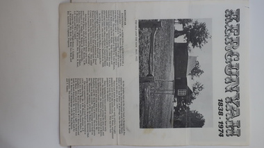
Kergunyah is a small town in the Kiewa Valley in north east Victoria. It is 10km south of Kiewa (town) and 23 km north of Dederang (town). it is farming country commencing in 1838, developing into a small community in 1974 with a School, Church, Post Office, Football Club, Young Farmer Club C.W.A. Netball Club, Card Club and Fire Brigade.Kergunyah is in the Kiewa Valley. Its history is important in the valley as it developed from a large pastoral run in 1838 into a small community supporting the local farming industry with essential organisations eg. school, fire brigade and social organisations eg. sporting teams, C.W.A.. Its history is significant as this leaflet has details of the organisations up to 1974 and this detail can be compared to organisations at Kergunyah today and can be compared to the history of other small rural communities. White stiff paper, folded to A4 size, with black and white photos on each of the 4 pages. Each page has detailed information under headings of community buildings and clubs in the small town. kergunyah; kiewa valley; small community; rural town; -
 Kiewa Valley Historical Society
Tin Coffee and Chicory, circa mid to late 1900's
Chicory was mixed with coffee to reduce the amount of coffee bean required to be used. This coffee "substitute" was due to the repeated fluctuations in availability of coffee beans (and price fluctuations) in the USA in the late 1800s and early 1900s resulting in the search for substitutes and additives to bulk out the available supplies. This was especially so during times of the major World Wars. Chicory was an excellent choice of fillers as it did not greatly influence the strong coffee bean taste. The first choice in USA households was coffee not tea and the influence of the American servicemen's thirst for coffee was a major thrust into the Australian "colonial" preference for a "cuppa" tea. Rural areas took longer to acquire a coffee "break" but with more and more subliminal advertising through "American" films the rural regions developed a growing preference for coffee, however the tea break alias "smoko" has lingered on.This coffee and chicory blend tin container is very significant to the Kiewa Valley in that it demonstrates that even in rural regions of Australia tastes and drinking preferences have changed by subliminal advertising as time goes by. The American "influence" whether by the "invasion" of friendly troops during the major wars or the avalanche of "American films" has altered some of the "dinky-di" Australian "true blue" tastes and mores. The availability of "straight " coffee supplies to rural areas was also in proportion to the level of all weather transport routes. In the late 1800's and early 1900's road freight had to contend with dirt roads, flooded roads, bush fires and grazing cattle/sheep in rural areas. The easier access that city households had with regard to replenishment of food and drink products, up until the mid 1900's, was severely retarded in rural areas. This extensively rusted tin of "Bushells Blue Label" Coffee and Chicory has an octagonal shaped body with a "push/pull" lid(tin).Three sides has reproduced painted ladies in "Roman dress" ladies picking the coffee beans. There is no reproduction of any chicory roots. There are two "Indian dressed" field workers(pickers) with turban head dress. On one side of the tin is "directions of use, net weight and manufacturer details."Bushells Coffee & Chicory", "NET 1-Ib. weight", " No. 144" "Under the Pure Food Act N.S.W. 1938" "by Bushells Ltd. No 144"chicory / coffee drinks, tin hydrated drink, rural food and drink consumption patterns, tinned food and drink -
 Kiewa Valley Historical Society
Scrap Book, Newspaper Clippings: 1949 - 1980s
Clare Roper collected and maintained newspaper clippings of historical interest to the Kiewa Valley Historical Society.Clare Roper grew up and lived in the Kiewa Valley at Tawonga. She was a member of the Kiewa Valley Historical Society for many years.A vanilla, green with sunset picture 'Photo Album' used to save newspaper clippings dated 1949 to late 1980s mostly covering the North East of Victoria. The Photo Album has 3 steel rings that snap open and shut. The pages have a clear plastic sheet that lifts off to place the newspaper cuttings which then 'stick' to the page. The clear cover is then replaced on top.There are 60 pages used both sides.Front cover "Photo Album". Spine 'Photos'.newspapers, historical articles, clare roper, kiewa valley, north east victoria, local press, photos -
 Kiewa Valley Historical Society
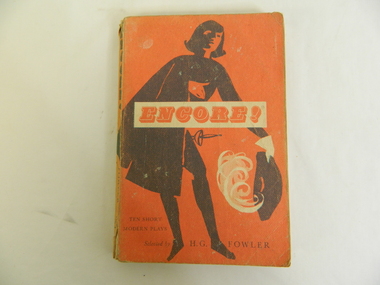
Book - Teacher Reference, Encore! Ten Short Modern Short Plays Selected by H. G. Fowler, 1962
Students in Form 4 were encouraged and taught to perform plays during the 1960s.G. Davies grew up in the Kiewa Valley at Tawonga and attended Mt Beauty Secondary College. Red soft covered book with black and white picture of girl (black) taking a bow and black writing on front and on the spine. The title is in red on white background.'G. Davies Form 4' on first page.school, education, drama, g. davies, tawonga, plays -
 Kiewa Valley Historical Society
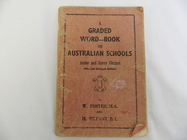
Book - School Text Book, A Graded Word Book for Australian Schools by W. Foster, M. A. and H. Bryant B. A
Spelling books were used in the Primary and Secondary schools during the 1950s. This book enabled the student to progress at his/her own pace. Roy Davies grew up and lived in the Kiewa Valley at Tawonga.Small faded red soft covered book with black writing on cover inside a border of a thin black line. In black: Junior and Senior Classes"Roy Davies 4B 1957". Inside cover page "accompanied, achievement, affair" hand written on inside title page.spelling, school, student, roy davies, education, mt beauty, tawonga -
 Kiewa Valley Historical Society
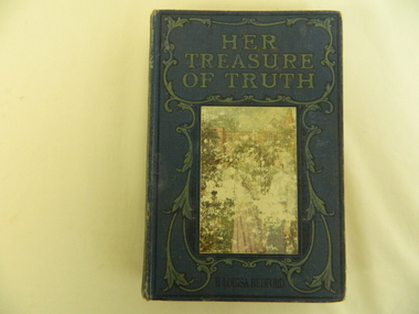
Book - School Prize, The Religious Tract Society, Her Treasure of Truth by H. Louisa Bedford
In 1911, students received prizes for highest marks. Books were appropriate prizes. Everil Fisher grew up and lived at Mongan's Bridge in the Kiewa Valley.Blue hard covered book with light blue title surrounded by light blue swirl on cover. On the spine - the title and author's name are embossed in gold. RTS is embossed in gold at the bottom of the spine. The decoration on the spine is light blue. Inside: Font is large. Between the title page and a picture is a clear sheet of 'tissue' paper.Everil Fisher / Highest marks / S. S. 3403 / 25. 4. 11 - Handwritten on first page.everil fisher, school prize, mongan's bridge primary school -
 Kiewa Valley Historical Society
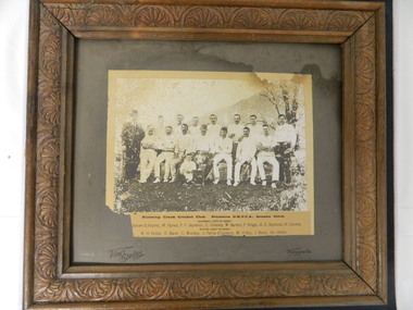
Photo - Running Creek Cricket Club
Running Creek belonged to the Upper Kiewa Valley Cricket Association and were premiers in 1913 - 1914. They dressed in whites with long sleeved shirts and trousers. The umpire was dressed very formally. The names of the players are local families and included brothers or relations with the same surname.Historical: Running Creek were premiers of the Upper Kiewa Valley Cricket Association in 1913 - 1914. Their team consisted of local men some of whom were related. The occasion was important enough to have a photo and to remember it possibly hanging the photo up in a public place eg. club rooms.Black & white photo of Running Creek Cricket Team, Premiers 1913 - 1914. Upper Kiewa Valley Cricket Association Far left - The umpire fully dressed in suit & hat and far right man with white shirt & black trousers. In between 13 cricketers in 2 rows and a child beside the cup at the front. Names of players are typed below the photo. Photo is glued on grey cardboard, framed in brown decorative wooden frame. Back: String attached 1 side only.Title, names of players. Grey cardboard - Vine's Studios / Wangaratta. On back handwritten "Donated by Mrs J. Woodside / Guluguba / Queensland / on 19 July 1972cricket. running creek. upper kiewa valley cricket association. sport. vine's studio. -
 Kiewa Valley Historical Society
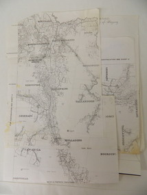
Parish Maps - Kiewa Valley
The Parish Maps show how the Counties were divided into allotments for buyers. On one the original owners are named and the sizes of their properties given. The reference numbers enable individuals research the history of the property. The other is on a smaller scale giving only the allotment numbers. The map with the names gives information on the early settlers of the Kiewa Valley. They show how the Kiewa Valley was divided up into allotments for town dwellers and farmers and enables further research.Two copies of Parish Maps of the towns in the Kiewa Valley. One gives the original owners and the other the reference numbers of the allotments.kiewa valley. parish maps. land owners -
 Kiewa Valley Historical Society
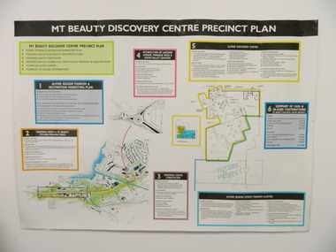
Poster - Mt Beauty Discovery Centre Precinct Plan
The current (2015) Mt Beauty Tourist Centre site was to be upgraded into a 'Sports Tourism Cluster' with funding from the Government and the Alpine Shire with 'In Kind' assistance from Falls Creek Resort management Board, Parks Victoria and the Local Community & Tourism Industry. This project didn't go ahead.The Mt Beauty town was handed over to the Alpine Shire in the 1960's after completion of the Kiewa Hydro Electric Scheme. Plans for up dating facilities are on-going but are rarely completed. This poster is an example of this.Very large laminated poster depicting 6 points for the Alpine Region Sports Tourism Cluster. Each point has a coloured border and background to black writing. There are 3 maps.mt beauty. tourism. discovery centre. sports cluster. -
 Warrnambool and District Historical Society Inc.
Title Search Document, 1930s to 1960s
These documents concern the property in South Warrnambool, Jetty Allotment 7, Section 4. They include a search made of the title of this property in 1937 and information on later purchasers of the property. The first owner of this property was James Cust who purchased it in April 1853. James Cust (1815-1860) came from Ireland to Australia in 1841. From 1847 on he farmed first at Woodford and then moved into Warrnambool and began land speculating.. In 1856 his property was valued at £20,000 but by 1858 he was declared insolvent following the insolvency of his financial backer, William Bateman and his properties were sold. He died in 1860 following an accident at a Ballarat gold mine. Other notable Warrnambool identities who owned this property on Pertobe Road included Thomas King, Christopher Beattie, Thomas Goodall, William McMahon and Alan Lane.These documents are of interest as they detail the history of a property in Warrnambool up to the 1960s. They are also an example of the type of property once owned by James Cust, an important early land speculator in Warrnambool. These are nine loose sheets of paper concerning a legal search made of a block of land in Warrnambool and later documents on the same property The papers contain handwriting in blue and black ink and pencil and one red stamp. One of the pages is an invoice for the charge made for the search.‘Searched 25/5/37 W.D. Richardson Titles Searcher 418 Little Collins Street Melbourne C1’james cust,, history of warrnambool -
 Warrnambool and District Historical Society Inc.
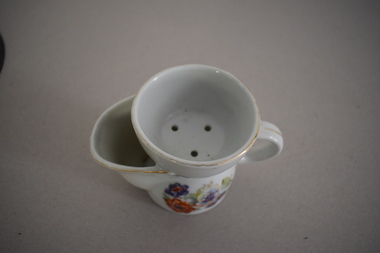
Artefact, Shaving mug, Early 20th century
This is a shaving mug which, together with shaving cream, hot water, a shaver with a razor blade and a razor strop, were the items used by men to shave faces and/or beards. Today these items have been replaced by the use of an electric razor or a plastic holder containing a razor blade. This item is retained as an attractive example of the mugs used by men for shaving purposes up to the 1950s and 60s. This is a white china shaving mug with a circular base, a handle, a wide-lipped opening and a top bowl with three drainage holes at the bottom. The sides of the mug have coloured painted flowers. On the base of the mug is an article from a newspaper regarding the disappearance of the shaving mug from general use (pasted on) and some handwriting, part of which is indecipherable. The handle and the rims of the mug have originally been gilt-edged. ‘Shaving Mug’ ‘This is quite an antique – used by all the 3 R….’ men’s accessories, warrnambool, history of warrnambool -
 Warrnambool and District Historical Society Inc.
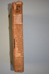
Letter book 6, Jan 1914 - 1917, 1914
This letter book contains letters, plans and sketch maps dating from 1914 to 1917. It came from the office of John William Crawley Junior, an engineer, architect and surveyor in private practice in Warrnambool and also the engineer for the Shire of Warrnambool from 1895 to 1935. His father, brother and son were also engineers and worked in that capacity or as the Shire Secretary for the Shire of Warrnambool, with the Crawley family recording a total of 132 years of service to the Shire of Warrnambool. This Shire existed from 1863 to 1994. The letter book was passed on the John Crawley’s son, Rolf, engineer for the Shire of Warrnambool from 1935 to 1968. It then came into the possession of Michael Hand who took over the private surveying practice of Rolf Crawley in Warrnambool. The Warrnambool and District Historical Society has acquired the letter book, along with several other Crawley ledgers, from the Michael Hand estate. This letter book is of considerable significance as it contains letters, maps and plans drawn up by John William Crawley, Junior, the engineer for the Shire of Warrnambool for 40 years. It will be very useful for researchers. This is a brown hard cover letter book with leather binding on the edges of the cover and on the spine. The leather is worn away in several places. There is gold lettering on the spine. The book has 750 pages of handwritten letters, maps and plans. The inside cover is of a mottled blue colour. There is an alphabetical index at the beginning of the book. ‘6’ ‘Letter Book 1914 to 1917’ john william crawley junior, warrnambool, rolf crawley, warrnambool, shire of warrnambool -
 Warrnambool and District Historical Society Inc.
Letter book 7, 1917-1920, 1917
This letter book contains handwritten letters, sketch maps and plans and dates from 1917 to 1920. It comes from the office of John William Crawley Junior, an engineer, architect and surveyor in private practice in Warrnambool and also the engineer for the Shire of Warrnambool from 1895 to 1935. His father, brother and son were also engineers and worked in that capacity or as Shire Secretary for the Shire of Warrnambool, with the Crawley family recording 132 years of service with the Shire of Warrnambool. The Shire existed from 1863 to 1994. The letter book was passed on to John Crawley’s son, Rolf, the engineer for the Shire of Warrnambool from 1935 to 1968. The letter book then came into the possession of Michael Hand who took over the private surveying business of Rolf Crawley in Warrnambool. The Warrnambool and District Historical Society then acquired this letter book, along with other Crawley ledgers, from the Michael Hand estate. This letter book is of considerable significance as it contains letters, plans and maps drawn up John William Crawley Junior, the engineer for the Shire of Warrnambool for 40 years. It will be very useful for research. This is a hard cover book of 745 pages. It has leather trim on the cover edges and the spine with gold lettering on the spine. The leather covering is scuffed and torn. The inside covers have a mottled blue lining. The book contains maps, plans and handwritten letters and has an alphabetical index at the beginning of the book. Most of the pages have been water-stained. ‘7 Private’ ‘Letter Book 1917 to 1920’john william crawley junior, warrnambool, rolf crawley, warrnambool, shire of warrnambool -
 Warrnambool and District Historical Society Inc.
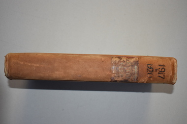
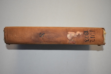
Ledger 10, Letters 1912 1923, 1912
This letter book contains letters and maps and dates from 1912 to 1923. It came from the office of John William Crawley Junior, an engineer, architect and surveyor in private practice in Warrnambool and also the engineer for the Shire of Warrnambool from 1895 to 1935. Hs father, brother and son were also engineers and worked in that capacity or as the Shire Secretary in the Shire of Warrnambool, with the Crawley family recording a total of 132 years of service to the Shire. The Shire of Warrnambool existed from 1863 to 1994. The letter book was passed on to John Crawley’s son, Rolf who was the engineer for the Shire of Warrnambool from 1935 to 1968. It then passed into the possession of Michael Hand who took over the private surveying practice of Rolf Crawley in Warrnambool. The Warrnambool and District Historical Society acquired the letter book, along with several other Crawley ledgers, from the estate of Michael Hand. This letter book is of considerable interest as it contains letters and maps drawn up by John William Crawley, a Shire of Warrnambool engineer for 40 years. It will be helpful to researchers. This is a black hard cover letter book with brown binding on the cover edges and the spine. Parts of the cover have been worn away. The spine once had gold lettering but this is mostly worn away. The book has 743 pages of handwritten letters and maps and an alphabetical index at the front. The pages are water stained.‘Letter Book 1912, 1923’john william crawley junior, warrnambool, rolf crawley, warrnambool, shire of warrnambool -
 Warrnambool and District Historical Society Inc.
Letter book 11, Letters 1926 - 1929, 1926
This letter book contains handwritten letters and sketch maps and dates from 1926 to 1929. It came from the office of John William Crawley Junior, an engineer, surveyor and architect in private practice in Warrnambool and also the engineer for the Shire of Warrnambool from 1895 to 1935. His father, brother and son were also engineers and worked in that capacity or as the Shire Secretary for the Shire of Warrnambool, with the Crawley family recording a total of 132 years of service to the Shire. The Shire of Warrnambool existed from 1863 to 1994. The letter book was passed on to John Crawley’s son, Rolf, the engineer for the Shire of Warrnambool from 1935 to 1968. It then came into the possession of Michael Hand who took over the private surveying practice of Rolf Crawley. The Warrnambool and District Historical Society acquired the letter book, along with several other Crawley ledgers, from the estate of Michael Hand. This letter book is of considerable significance as it contains letters and maps drawn up by John William Crawley, Junior who had a private engineering and surveying practice in Warrnambool and was the engineer for the Shire of Warrnambool for 40 years. It will be very useful for researchers. This is a green hard cover letter book of 1000 pages. It has handwritten letters and sketch maps and an alphabetical index at the front. The cover has brown binding on the edges of the cover and the spine. There is gold lettering on the spine. The cover has an inside mottled red lining. There is a mauve stamp on the first page. ‘Letter Book 1926 to 1929’ ‘P’ ‘Rolf. L. Crawley, Civil Engineer, Drainage and Water Supply Engineer, Licensed Surveyor, Registered Architect, Warrnambool’ john william crawley junior, warrnambool, rolf crawley, warrnambool, shire of warrnambool -
 Warrnambool and District Historical Society Inc.
Letter book 13, 1920
This letter book contains letters, sketch maps and plans and dates from 1920 to 1923. It came from the office of John William Crawley Junior, an engineer, architect and surveyor in private practice in Warrnambool and also the engineer for the Shire of Warrnambool from 1895 to 1935. His father, brother and son were also engineers and worked in that capacity or as the Shire Secretary for the Shire of Warrnambool, with the Crawley family recording a total of 132 years of service to the Shire. The letter book was passed onto John Crawley’s son, Rolf, the engineer for the Shire of Warrnambool from 1935 to 1968. It then came into the possession of Michael Hand who took over the private surveying business on Rolf Crawley in Warrnambool. The Warrnambool and District Historical Society acquired the letter book, along with several other Crawley ledgers, from the estate of Michael Hand. This letter book is of considerable significance as it contains letters and maps drawn up by John William Crawley, an engineer in the Shire of Warrnambool for 40 years. It will be very useful for researchers.This is a dark red hard- cover letter book of 1001 pages. The book has brown binding on the corners of the cover and on the spine. There is gold lettering on the spine. The inside of the cover is lined with a multi-coloured mottled pattern. The cover is stained and scuffed. The pages contain handwritten letters, sketch maps and plans and an alphabetical index at the front. There are three loose pages. There is a mauve stamp on the first page.‘Letter Book 1920 to 1923’ ‘Rolf. L. Crawley Civil Engineer, Drainage and Water Supply Engineer, Licensed Surveyor, Registered Architect, Warrnambool’ john william crawley junior, warrnambool, rolf crawley, warrnambool, shire of warrnambool -
 Warrnambool and District Historical Society Inc.
Letter book 14, 1923
This letter book contains letters, sketch maps and plans and dates from 1923 to 1926. It came from the office of John William Crawley, Junior, an engineer, surveyor and architect in private practice in Warrnambool and also the engineer for the Shire of Warrnambool from 1895 to 1935. His father, brother and son were also engineers, working in that capacity or as the Shire Secretary for the Shire of Warrnambool, with the Crawley family recording a total of 132 years of service to the Shire. The Shire of Warrnambool existed from 1863 to 1994. This letter book was passed on to John Crawley’s son, Rolf, the engineer for the Shire of Warrnambool from 1935 to 1968. It then came into the possession of Michael Hand who took over the private surveying business of Rolf Crawley in Warrnambool. The Warrnambool and District Historical Society acquired the letter book, along with several other Crawley ledgers, from the estate of Michael Hand.This letter book is of considerable significance as it contains letters, maps and plans drawn up by John William Crawley, an engineer and surveyor in private practice in Warrnambool and the engineer for the Shire of Warrnambool for 40 years. It will be useful for researchers. This is a brown hard cover letter book of 1010 pages, with brown binding on the corners of the cover and on the spine. The cover is cuffed and torn. There is gold lettering on the spine. The book contains handwritten letters, maps and plans and an alphabetical index at the front, The pages are water-stained. There is a mauve stamp on the first page.‘Letter Book 1923 to 1926’ ‘J. Wm. Crawley Shire Hall Warrnambool (Private)’ ‘Rolf L. Crawley Civil Engineer, Drainage and Water Supply Engineer, Licensed Surveyor, Registered Architect, Warrnambool’ john william crawley junior, warrnambool, rolf crawley, warrnambool, shire of warrnambool -
 Warrnambool and District Historical Society Inc.
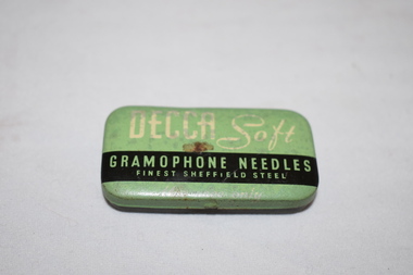
Gramophone Needles, Tin of Gramophone Needles, 1940s
This tin of gramophone needles was produced to be used in conjunction with a Decca Gramophone. The Decca company was founded in 1914 by Barnett Samuel and Sons and their gramophone as patented as the world’s first portable gramophone. The company became known as the Decca Gramophone Company in 1928. Portable gramophones became very popular, especially with the soldiers in World War One. Today the gramophone is largely a collector’s item and has been replaced by more sophisticated sound systems. These needles and their box are of interest as an example of a recreation product in the past. Gramophones were found extensively in homes up to the 1950s. This is a small rectangular-shaped tin with rounded edges. It has a hinged lid painted green on the top. The top has printed material in green, black and white lettering. Inside the tin is black paper lining and inside the lining are about 50 gramophone steel needles. This is not a full tin. The needles are in good condition but the tin is a little rusty‘Decca Soft Gramophone Needles Finest Sheffield Steel Use Once Only’ gramophones, history of warrnambool -
 Port of Echuca
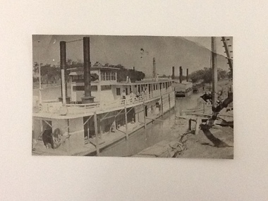
Photograph - Black and white photograph, approx. 1980
P.S. Captain Sturt, with a pile driver in the background. Possibly at Blanchetown. There are 5 men on the upper port deck. The paddle-steamer has 2 funnels and the pile driver has 4 funnels. The wheelhouse is above the upper deck.Demonstrates the use of floating pile drivers to assist in the construction of bridge or wharf building along the river Murray river in approximately the 1920's. The Captain Sturt is in close up so the structure of the paddlesteamer is clear. Rectangular, black and white copy of original photograph of P.S. Captain Sturt, with a pile driver in the background. Possibly at Blanchetown. There are 5 men on the upper port deck. The paddle-steamer has 2 funnels and the pile driver has 4 funnels. The wheelhouse is above the upper deck.In pencil on back: CaptainSturt, Blancheltown or similar. Pile driver in background. On photograph "Captain Sturt" is visible on front and side of the paddlesteamer.blanchetown, p.s.captain sturt, pile driving, murray river, south australia, 1920's -
 Port of Echuca
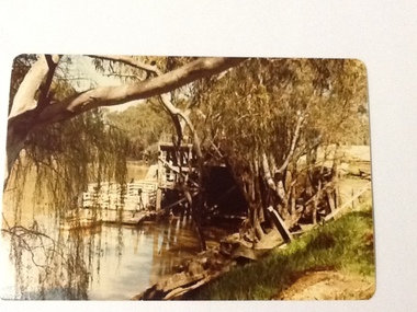
Colour photograph, Approx.1979
This photograph shows a punt (with a dingy tied to it ) moored to the wharf structure on the Murray river at Echuca. Punts were used to transport people and goods from one side of the river to the other.Punts were used to cross the Murray river at many spots before bridges were built. Henry Hopwood set up his initial business with punts across the Murray and Campaspe rivers, charging people, animals and vehicles to cross the rivers.Colour photograph of a punt tied to the port structure, seen through the foliage of gums on the river bank.On reverse:" This paper manufactured by Kodak"port of echuca, hopwood's punt, echuca, port of -
 Port of Echuca
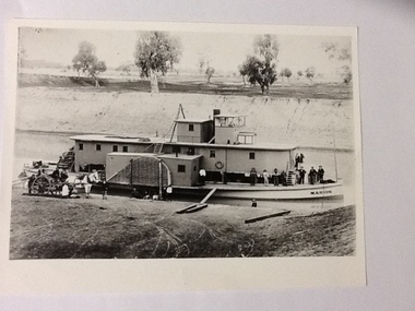
Black and white photograph, Earliest 1897
P. S. Marion Dimensions: 107 ft 11 in X 5 ft 3 in Tonnage: 157 tons Built: 1897, at Milang, S. A. References: Book: "Murray River Paddlesteamers" by D. Wardle. pp.22 Riverboats and Rivermen by W. Drake & M. PagePaddlesteamers were a common form of transport along the Murray river in the early 20th century. This photo shows a number of travellers on the boat, judging by their attire, workmen, cook, men in suits and ties as well as a group of people sitting on the bank, possible a woman and children with dog waiting for the boat to depart. There is also a horse drawn wagon with a number of people on and around it that could be waiting to pick up goods (or have unloaded) from the boat. At the back of the boat stacks of wheat bags (?) are visible.Black and white photograph of P. S. Marion moored by a river bank. There is a group of men standing towards the bow and a horse drawn carriage on the bank near the stern. Copy of an original photograph.On the front: MARION on the bow of the boat and on the wheelhouse. On reverse, in pen: Marion. where? Stamped in black: National Library of Australia.riverboats,, paddle steamers, p. s. marion -
 Port of Echuca
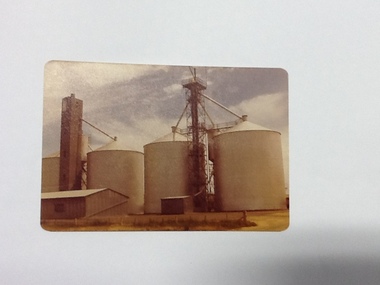
Colour Photograph, Approx.1979
This is of historical and social significance in that Echuca was a terminal for rice distribution and processing. The rice mills were located in Annesley st next to the railway line. Here 4 silos and 2 of the conveyor towers are visible, looking to the east. The rice mills employed many people in Echuca. Echuca has historically had many storage silos for grains. The rice mills in Echuca stored and processed rice up until the early 1990s. This photograph clearly shows the rice silos and conveyor towers that were in Annesley street .Colour photograph (postcard size) of rice mill silos, Echuca. Photograph shows 4 silos with 2 conveyor towers.In blue pen on reverse:"35A-36". Printed in red on reverse:"It's Kodak for color. Nov.79. Print made by Kodak. M."rice mills, echuca, echuca-industry