Showing 4547 items matching "burnley"
-
 University of Melbourne, Burnley Campus Archives
Photograph - Black and white photocopy, Carine Williams (nee Wettenhall) et al, Mending the Mower, 1929
1a. Donated by Carine Williams (nee Wettenhall) (1930) in 1991 for the Centenary Year. 1b. Photograph donated by Pat McVickar in 1991 for the Centenary Year, a note associated with the photographs states that she went to England in 1930 and finished the course at Burnley in 1931. 2. Copy of the original Sepia (by E.B. Littlejohn) lent by P. Hayne(s) (1928) for the 1991 Centenary Year who described it as a group of 15 students and Frank Weavers. 10 of these people graduated in 1928 including P.. Haynes, H. Kirkhope (centre with neck tie?) and Harry Wiseman, one of 2 boys in applecatchers?" (large spacious underwear, must mean trousers). Dairy in the background.1. 2 Sepia photographs and 2. Colour photograph. Copy of b/w photograph lent in the Centenary Year, 1991, by P. Haynes (1928).1. On reverse, "Mending the mower (hand-pushed, of course) 1929."mower, carine williams (née wettenhall), centenary, pat mcvickar, 1991, e.b. littlejohn, p. haynes, students, frank weavers, h. kirkhope, harry wiseman, mending mower, student outside class -
 University of Melbourne, Burnley Campus Archives
Document - Reports, Submissions for accreditation
Nos. 2, 3 & 4 have name Ivo A. Dean. No. 1 has some annotations on 2nd copyburnley college, victorian college of agriculture & horticulture, accreditation, horticulture, recreational turf management, nursery production, crop production -
 University of Melbourne, Burnley Campus Archives
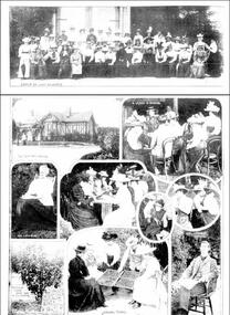
Newspaper - Newspaper Cutting, The Leader, The School of Horticulture, 1899
Photocopy of article in "The Leader," February 18, 1899 about the introduction of female students. Includes illustrations from 'The School of Horticulture, Burnley' (1) View of the Grounds. (2) Instructing a Class. (3) A Group of Students. The Principal, Mr C. Bogue Luffman. Original of article without photographs. Another photocopy version, same date - Page of photographs: Group of Ladies, The Principal's House, A Lesson in Budding, Mrs Luffmann, Specimen Dwarf Apple Tree in Full-Bearing, Sorting Prunes, Mr C Luffmann Principalthe leader, female students, charles bogue luffman, school of hortriculture, mrs luffmann, mr c luffmann, principal, prunes, budding, outside classes, principal's residence, apple tree -
 University of Melbourne, Burnley Campus Archives
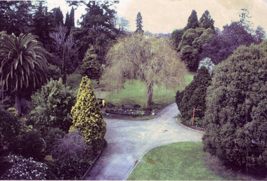
Photograph - Colour photocopy, James (Jim) Pleasance, Garden View, 1990
Colour photocopy of a photograph originally taken by Jim Pleasance as a slide. Photograph taken from a Travel Tower looking down on to the crossroad paths by the Lily Ponds. Taken on the same day as the photograph used in, "Green Grows Our Garden," A.P. Winzenried opposite p 27. The caption reads, "Garden Staff Paula Cave and Andrew Smith modifying Luffman's Ponds, Burnley Gardens, 1990. The island in the western end of the pond is being reduced in size so that people entering the garden get a view down the gardens of the pond." jim pleasance, travel tower, lily ponds, green grows our garden, a.p. winzenried, staff, paula cave, andrew smith, burnley gardens, 1990, luffmann ponds, refurbishment of lily ponds -
 University of Melbourne, Burnley Campus Archives
Plan, Herbaceous Border, 1984-1997
(1) Summer Autumn Herbaceous Border VCAH 1984 - Plant Plan. (2) 2 tracing paper copies The Herbaceous Border VCAH Burnley 6.7.87, names of plants around it. (3) Tracing paper copy, The Herbaceous Border Planting Schedule 12.8.87 and 1 paper copy with annotations in pencil. (4) Planting Plan, 1 with "1991" written on it, and several sketches and copies. (5) Coloured plan, names of some plants different to (4). (6) Coloured plan with some differences to (5). Dated 1997.herbaceous border, burnley vcah, garden beds -
 University of Melbourne, Burnley Campus Archives
Photograph, Pruning Day 1980, 1980
pruning, fruit trees, burnley, public day, administration building, agnotes, blossom tree, pruning demonstrations, orchard, field station -
 University of Melbourne, Burnley Campus Archives
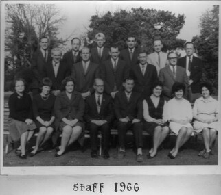
Photograph - Black and white print, Ross Everard, Staff 1966, 1966
Black and white photograph. Official Staff photograph. Some seated on benches and some standing in the Burnley Gardens. L-R: Front Row: C.L.(Connie) Hoffman, Jill Murray, Freda Wannenmacher, T.H. Kneen, E.B. Littlejohn, Rosemary Hamley, Helen Requini, Mrs. Jackson (Canteen), ?. Middle Row: George Grumont, Ken Elliott, A.B.T. Courtney, J.B. (Jack) Nowell, A.J. (Jack) Farrance. Back Row: W.J. (Bill) Nicholls, J.B. Dimelow, Laurie Metzeling, Ian McCure, Clarie Henderson, Phil Bandt.On reverse, "With the compliments of Ross Everard."ross everard, c.l.(connie) hoffman, jill murray, freda wannenmacher, t.h. kneen, e.b. littlejohn, rosemary hamley, helen requini, mrs. jackson, canteen, george grumont, ken elliott, a.b.t. courtney, j.b. (jack) nowell, a.j. (jack) farrance, w.j. (bill) nicholls, j.b. dimelow, laurie metzeling, ian mccure, clarie henderson, phil bandt, staff -
 Mission to Seafarers Victoria
Photograph - Digital Image, series, 05/04/2019
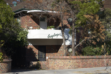
Graylings estate was purchased by Frederick Race Godfrey around 1872 on return of a family trip to England. Reverend Gurney Goldsmith met Ethel Godfrey here while he was invited for lunch and rose her interest in the cause of the sailors. The Godfreys organised two picnics for sailors on their property, one in 1905 and one in 1910. The estate was auctioned and subdivided in 1910 after Fredrick's death. But early the same year he had a second house built on the estate. A brick building that may be what is now the Graylings apartments. According to electoral rolls, Ethel Godfrey and her sisters Frederica and Winifred lived at 95 Alma Road. Ferderica Godfrey, one of the earliest female student of Burnley Horticultural College (1899 or1900-1903) is thought to have created the landscaping of the Graylings gardens. Street signs in St Kilda East depicting the area surrounding the former Grayling estate owned by Frederick Race Godfrey until his death in 1910.graylings, frederick race godfrey (1828-1910), ethel augusta godfrey, alma road, st kilda east, burnley horticultural colleg, frederica godfrey, rica godfrey, rita godfrey -
 Cheese World Museum
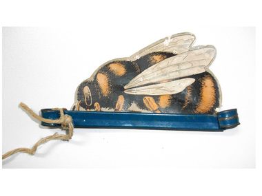
Advertising mobile, Barnes Honey bee
The Percy Uebergang family lived at Tooram Park, Allansford from 1912 until 1992. Percy and Myrtle Uebergang's children were twins, Ray and Joyce born in 1926 who lived at Tooram Park until their deaths, Ray in 1986 and Joyce in 1992. Neither Ray nor Joyce married and following the death of her brother Joyce set up the Ray and Joyce Uebergang Foundation which supports the local community. This advertising mobile is part of the collection of items given into the care of the Cheese World Museum. The van Nooten family purchased the neighbouring property Tooram from the Neale family. Honey bee printed on card and mounted in a blue painted metal holder. On the front the bee is striped black and orange with 2 large wings and 1 small wing in white with black line detail. On the back is advertising material for Barnes honey -text and a drawing of a bee with wings folded. The metal stand has a loop at either end. The loop on one end has a piece of string tied through it to hang up the bee mobile.BARNES/28 FIRST PRIZES/PURE HONEY/Awarded GRAND PRIX. Franco-British Exhibition/HONEY/HOMELL/WHOLEMEAL FLOUR/SELF-RAISING/For SCONES, BISCUITS and BREAD/FRU-ITY FLAKES/For PORRIDGE/SUNLIT/CREAM HONEY/W.J. & F. BARNES Pty Ltd/550 SWAN ST.,/BURNLEY, (printed) JANET/VAN/NOOTEN (child's handwriting in pencil)allansford, advertising material, barnes honey, bees, honey, uebergang, van nooten, tooram -
 University of Melbourne, Burnley Campus Archives
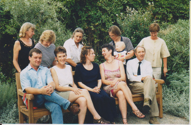
Photograph - Colour prints, Unveiling the Seat in the Grey Garden, 2000
Photographs donated by Michèle Adler 2017 past FOBG PresidentThe first garden bench donated by the Friends of Burnley Gardens. (1)'Unveiling the seat in the grey garden,' L-R Back Row - Carol Sorrell, Julie-Ann Webster, Dorothy James, Jane Geeson, Barb Brockly. L-R Front Row - Phil Tulk, Elspeth Ferguson, Suzanne Borck (worked in Administration), Sandi Pullman, Greg Moore (Principal). (2, 3) Greg Moore cutting the ribbon. (4) Jane Geeson and baby, Barb Brockley (5) Jane Geeson and baby. (6) Julie-Ann Webster. (7, 8) Trish Mooney (Gardener).garden bench, friends of burnley gardens, fobg, unveiling, grey garden, carol sorrell, dorothy james, jane geeson, barbara brockley, phil tulk, elspeth ferguson, suzanne borck, sandra pullman, greg moore, julie-ann webster, trish mooney -
 University of Melbourne, Burnley Campus Archives
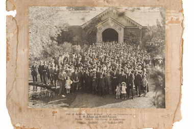
Photograph - Black and white prints and negative, Sutcliffe & Akers Photo, Audience for Poultry Lecture, 1914
Note by E.B. Littlejohn 4 March 1992, "Also identified: Bert Clinton (another poultry expert) a world expert on poultry parasites, second on left of small boy in front row. E.E. Pescott front row third from right."Large black and white photograph pasted on to cardboard. 3 copies black and white photographs and negative. Group of approximately 200 people outside entrance to Pavilion. Copies donated by Isobel McLennanCaption on original and 1 copy, "Part of Audience which attended Lecture and Demonstration by Mr. A. Hart and Mr. A.V.D. Rentoul, Poultry Experts. Department of Agriculture Burnley Gardens 21st November 1914." On reverse 2 copies, "Part of audience for lectures by A.Hart & A.V.D. Rentoul, poultry experts, D. Of Ag 21/11/1914. Note Bert Clinton, E.E. Pescott (Principal.)"pavilion, audience, lecture, demonstration, a. hart, a.v.d. rentoul, poultry experts, department of agriculture, burnley gardens, bert clinton, poultry -
University of Melbourne, Burnley Campus Archives
Plan, Swan Street Entrance. Also see B15.0352, 1988-1998
(1) 1 coloured and 2 copies, hand drawn , and 4 tracing paper sketches. Concept and Drawing by Steve Mullany, Lecturer V.C.A.H. Burnley, 09.12.1988. (2) 2 copies on tracing paper, original on paper with some additional notation and 3 copies of Landscape Plan by Steve Mullany 3 Feb 1989. (3) Photocopy of Project Eden, Swan Street, Richmond - Landscape Plan LA2 Project No 682 by Mark Mc Wha Pty. Ltd. Nov 1997. Includes Irrigation and Plant Schedule. (4) Coloured, Swan St Frontage Planting Scheme by P. Tulk for AMRAD 19.2.1998. -
 University of Melbourne, Burnley Campus Archives
Photograph - Photographs, Publicity Branch Victorian Department of Agriculture, Pruning, Grafting and Propagating Demonstration, c. 1960
Black and white photographs in an envelope marked O.H.M.S. Department of Agriculture, Burnley Gardens, E.1. All stamped,"Photograph by Publicity Branch Victorian Department of Agriculture." (1)-(2) B1687A-B Heavily pruned fruit tree. (3) B1688 Grafting tools. (4)-(8) B1689A-E Cutting techniques. (9)-(15) B1690A-G Joining graft techniques. (16)-(21)A-F Camellia graft. (22)-(26) B1692A-E Magnolia air-layering. (27)-(31) B1693A-E Plum root cuttings and scions and materials. (32)-(36) C668A-E Removing and planting rooted magnolia graft.department of agriculture, burnley gardens, pruning, fruit trees, grafting, tools, cutting, techniques, camellia, magnolia, plum, air-layering, approach grafting, whip and tongue grafting -
 University of Melbourne, Burnley Campus Archives
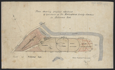
Plan, John S. Jenkins, Plan showing proposed adjustment of boundaries of the Horticultural Society's Gardens in Richmond Park, c.1880-1884
Plan on linen fibre cloth. Shows layout of Burnley bound by Swan St., Yarra River and part of Richmond Park, coloured areas showing proposed area to be added to Park, the old road, shrubbery, new hall, old garden, recent extension and proposed further extension (crossed out in red ink). Scale 4 chains:1 inch. Probably drawn by John S. Jenkins, Town Surveyor, Richmond. Has been photographed so that additional copies can be made. On a CD plus 3 negatives, plus small coloured print. (Also copy glazed and framed for Centenary Exhibition - B92.0540.)john s. jenkins, gardens, richmond, hoticultural society of victoria -
Whitehorse Historical Society Inc.
Article, Time stood still
In 1869 Mount Pleasant Common School opened, first Principal, John Brown, later named Vermont Primary School.In 1869 Mount Pleasant Common School opened, first Principal, John Brown, later named Vermont Primary School. In 1954 a new building erected in Nurlendi Road. 2 years later another building constructed and remaining students on Canterbury Road relocated too. The old building was occupied by a Glen Waverley group opening a church school in 1990. The building was vacant again and in 1991 a fire almost destroyed the old school. Finally in 1993 the old school has been relocated to Nurlendi Road and refurbished.In 1869 Mount Pleasant Common School opened, first Principal, John Brown, later named Vermont Primary School. primary schools, vermont primary school, no. 1022, mount pleasant school, brown, john, nurlendi road, vermont, hunter, kelly, burnley, carina -
 University of Melbourne, Burnley Campus Archives
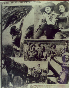
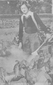
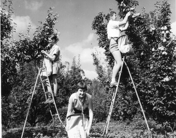
Photograph - Colour print, A.P. Winzenried, Girl Harvesters at Work, 1931-1990
Photograph made by A.P. Winzenried for, "Green Grows Our Garden," p73Colour photograph. Copy of a patchwork of 5 photographs of female students which appeared as newspaper illustrations c.1933, made by A.P. Winzenried. The caption reads, "Girl Harvesters at Work. Girl farming students at Burnley Horticultural Gardens are busy this week. They undergo two years practical and theoretical training in many... farming work. Pictures show: 1. Hay forking by the "weaker" sex. 2. Miss Joy...Miss Freda Poynter, typical students, enjoying billy tea. 3. A happy group on the...a crop of oats. 4. A reaping mower going round the crop. 5. Miss Thelma (Johnson?) drives old Don and the mower." See B99.1057.female students, a.p. winzenried, green grows our garden, burnley horticultural gardens, freda poynter, thelma johnson, don, donald, horse, srtudents working outside, west orchard, horse drawn mower, hay, recreation, oats, farming, reaping mower, newspaper cutting -
 University of Melbourne, Burnley Campus Archives
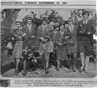
Photograph - Black and white and sepia prints, The Sun-News Pictorial, Back From the Sweet Fragrance of the Bush, 1927
All donated by Ella Chalmers (nee Fry) (1928).(1) Sepia photograph and Newspaper Cutting. Photograph of an illustration from a Newspaper article in the Sun-News Pictorial, Tuesday, September, 27, 1927, "Back from the sweet fragrance of the bush with armfuls of wildflowers for the exhibition of wildflowers to be opened by Lady Somers at St. Kilda Town Hall today. These girls had a happy time at Ringwood yesterday." (2) B/w photograph cut from a journal with the caption, "Students of the Burnley Horticultural College (who started the new term last Tuesday) with Mr. Russ (Practical Demonstrator), Mr. A. Jessep (Principal) and Mr. Harrison (Science Master)." and, "1927." Group of students standing, seated on benches and seated on the lawn in the Ornamental Garden.ella chalmers (née fry), burnley horticultural college, george russ, a.w. jessep, principal, mr. harrison, science master, student group, lady somers, st kilda town hall, exhibition of wildflowers, students, wildflowers, newspaper cutting -
 University of Melbourne, Burnley Campus Archives
Album - 35mm Colour slides, Plant Sales and Garden Week, 1988-1996
1-18. labelled "Oct 29 Plant Sale 1988" Nov 88. 19-36. labelled "Nov 4 Plant Sale 1989" Nov. 37-43. labelled "1990" (Plant Sale) Dec 90. 44-50. labelled "Garden Week 1990" and "Burnley Gardens" Apr 90. 51- 56. labelled "Nov 2 Plant Sale 1991" Nov. 57-66. labelled "Plant Sale 1992" Oct. 82- showing advertising posters for school fairs, one dated Oct 1995 Apr 1996. 67-81.labelled "Plant Sale 1996" Nov. 3 slides of advertising for it Oct. 1 slide "Labelling Austraflore"plant sale, garden week, burnley gardens, school fairs, austraflore -
 University of Melbourne, Burnley Campus Archives
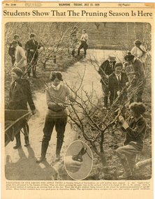
Newspaper - Newspaper Cutting, The Sun News-Pictorial, Students ShowThat The Pruning Season Is Here, 1929
Newspaper cutting from The Sun News-Pictorial, July 23, 1929. Photo of 12 students pruning apple trees, with a close-up of secateur technique. The caption reads: "Daughters of Eve among the apple trees at Burnley School of Horticuture are still lending their support to the apple-a-day adage first advocated in the Garden of Eden. They are shown pruning the apple trees in the orchard, which is in the charge of Mr AW Jessep. Inset is the correct method of cutting to an external bud on the tree. There are 34 girl students being trained at the school for professional positions as agriculturists. Many former students have won good posts in Australian States. The agricultural course occupies two years and carries a special certificate."the sun news-pictorial, students, female students, a.w.jessep, burnley horticultural college, apple trees, pruning, orchard, students working outside, secateurs -
 University of Melbourne, Burnley Campus Archives
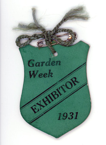
Photograph - Photograph and newspaper cuttings, Judith Cowley, Margaret Cowley (nee Doherty), 1931
margaret cowley nee doherty, garden week 1931, students working outside, female students, orchard, margaret cowley, margaret doherty -
 University of Melbourne, Burnley Campus Archives
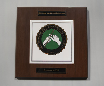
Plaque - Plaque and Research Agreement, The International Plant Propagators' Society Five Year Membership Recognition Plaque and Research Agreement Document, 1995 -2013
Plaque was presented in 2013 and was hung on the staff room walls until 2015. The letter to Ross Gregory Hall was written by Jolyon Burnett, Senior Industry Program Manager, granting funding for NY538 International Propagators Society Australian Region Annual Conference, Melbourne, May 1996. The agreement between The Horticultural Research and Development Corporation and the Faculty of Agriculture, Forestry and Horticulture for this project was signed by Gregory Moore, Principal of the College in 1995.1. Commerative plaque mounted on bevilled varnished wooden board for Five Year Membership Recognition (2008-2013). Presented in 2013 to the college. 2. Letter to Mr Ross Gregory Hall, Senior Lecturer (Production Management) dated 25 October 1995 from Jolyon Burnett of the Horticultural Research and Development Corporation (NSW) accepting his application for funding of the NY538 International Plant Propagators Society Australian Region Annual Conference Melbourne May 1996 3. Research Agreement between The Horticultural Research and Development Corporation and the Faculty of Agriculture, Forestry and Horticulture - Burnley for an approved NY538 project. Signed by Gregory Moore Principal of the College 27/11/1995 (6 A4 pages)1. Five Year Membership Recognition THE INTERNATIONAL PLATN PROPAGATORS' SOCIETY 1951 quaerere et impertire Presented in 2013. Logo in center.ross gregory hall, jolyon burnett, gregory moore, international plant propagators' society, annual conference 1996, burnley college -
 University of Melbourne, Burnley Campus Archives
Plan, Pat de Moulpied, Rose Garden, 1988
Most of these plans were held in Geoff Olive's office. (1) Preliminary concept South-East corner Burnley Gardens Re-design Proposals, Amenity Horticulture III, drawn by Pat de Moulpied 1988. Original turf path destroyed after Garden Week to be replaced with paving donated by Boral. (2) Rose Garden Site Analysis by Peter Jans, Parks & Gardens 1989, pencil on paper. On reverse, "B. Site Analysis & Design Changes. (3) 2 copies pencil on tracing paper, Planting plan. (4) Planting plan on tracing paper. (5) Planting plan (roughly final version?), 1 tracing paper, 6 photocopies. (6) Notes from Geoff Olive addressed to James Hitchmough. Also photocopies of 1 - 5 and some rough sketches. Notes made by Guide Jean Corbett on the History of the Rose.pat de moulpied, peter jans, gardens, geoff olive, andrew smith -
 University of Melbourne, Burnley Campus Archives
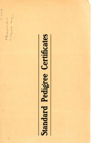
Document - Documents, Registers, Correspondence and Photographs, College Records, Livestock Records, 1919-1951
(1) 2 copies and handwritten notes, School of Primary Agriculture and Horticulture Burnley Gardens "Victoria" Jersey Herd Table No 1, Pedigree then Table: No., Name, Sex, Sire, Dam, Dropped, 24 January 1919 -8 August 1947. (2) 3 copies and handwriten notes, "Victoria" Jersey Herd Milk Fat and Butter Records of cows on hand at 8 August 1947 Table 2: Name, Born, Milk Test, Butter Fat, Class, Calved. (3) 3 copies and handwritten notes, "Victoria" Jersey Herd Milk Fat and Butter Records of cows of 1st, 2nd, 3rd, 4th and 5th generations Table No 3. (4) 2 copies Table No 4: Pedigree.(5) 2 copies Table No 5: Sires used Table: Name, For Pedigree see -. (6) Book of Standard Pedigree Certificates, some stubs with a name on them, V. Starbright's Flirt, V. Elizabeth Anne handwritten on outside. Second book unused. (7) File: "Stock Breeding Cattle Herd Book (Jerseys)" dated 27 May 1936 to 13 September 1950 includes Correspondence, Notices, Jersey Herd Society, AGM of The Australian Jersey Herd Society (Victorian Branch). (8) File: Stock Breeding Cattle Burnley 1943, dated 4 February 1943-8 August 1951, Livestock returns, Memoranda, sale notices. (9) File: Completed Correspondence Cattle dating from 2 December 1926, drawing of cow with markings of calf to be filled in, photographs of calves, correspondence re purchases and sales of cattle, Pedigrees.school of primary agriculture and horticulture, burnley gardens, victoria, jersey herd, milk, butter, records, cows, dairy, pedigree, pedigree certificates, stubs, v. starbright's flirt, v. elizabeth anne, stock breeding, cattle, australian jersey herd society, livestock, correspondence, friesian, holstein friesian, wedding bell, patti bell, tinkee bell, pattidale, carroway, oakhall, calf -
 University of Melbourne, Burnley Campus Archives
Newspaper - Newspaper Cutting, The Argus, Call of the Outdoors - Girls with 'Green Fingers', 1953
Four photocopied pages which together make up an article by Barbara Wallis published on page 16 of The Argus, July 16, 1953. The original newspaper cutting was lent by Mary-Anne Connors in 1991 (contact details in paper catalogue). Includes photographs of Burnley students Mary Lee, Joan Fitzgerald, Jane Ogden and Anne Sheldon. Others mentioned are: Mary Louise Leng, Jennifer Edwards, Justine Mitchelson, Helen Eastman, Alison Howie, Valerie Sloane and Eleanor McClelland. The article discusses what the students will do or hope to do after graduation. All (Mary Lee, Joan Fitzgerald, Jane Ogden and Anne Sheldon on the photograph and Mary Louise Leng, Jennifer Edwards, Justine Mitchelson, Helen Eastman, Alison Howie, Valerie Sloane and Eleanor McClelland) but 3 of them graduated in 1951 and 1954. mary lee, joan fitzgerald, jane ogden, anne sheldon, mary louise leng, jennifer edwards, justine mitchelson, helen eastman, alison howie, valerie sloane, eleanor mcclelland, female students, barbara wallis, mary-anne connors, careers for girls, careers in horticulture -
 University of Melbourne, Burnley Campus Archives
Photograph - Black and white print, Publicity Branch Victorian Department of Agriculture, Students Picking Fruit, 1958-1960
These students are from the first intake for the Diploma of Horticulture who graduated in 1961.Black and white photographs. Students picking apples and pears. The students are wearing special bags which attach by straps round the neck and around the waist, with a flap that opens at the bottom allowing the fruit to be removed. The bags are stamped "Burnley Gardens,". 7 photographs by the Publicity Branch Victorian Department Of Agriculture Ref. No. c.1317. (1) D Left to right: John Richards, Dorothy Issell, Helen Page, picking pears. Also see B92.560 enlarged. (2) E Doroth Issell picking apples. (3) F (2 copies) 6 students picking apples. (4) H Helen Page picking apples. (5) I John Richards, ?, Helen Page, picking apples. 3 unmarked photographs (6) 1 John Richards, Helen Page, Dorothy Issell, picking pears. This photograph used as an illustration in, "Green Grows Our Garden," A.P. Winzenried p99. (7, 8) 2, 3 John Richards, Dorothy Issell, Helen Page picking pears. fruit picking, apples, pears, diploma of horticulture, 1961, bags, john richards, dorothy issell, helen page, green grows our garden, a.p winzenried, students working outside, orchard -
 Melbourne Tram Museum
Document - Research Notes, H. S. McComb, "Orders in Council - Relating to Bridges", c1930
Type and hand written notes, on quarto or scrap paper about Orders in councils relating to Melbourne Tramway bridges - 17 sets of notes, each retained by a paper clip. 1 - Caulfield line at Smith St 2 - Church St Bridge Act 3 - Spencer St Bridge Act 4 - Melbourne to Burwood Tramways Act 5 - Footscray Tramway Act 6 - Fitzroy Northcote and Preston Tramways Act 7 - Hawthorn - Under line at Burwood and over line at Burnley 8 - Burke Road Camberwell 9 - St Kilda rail line at Kerford Road 10 - High St Deepdene - Fairfield to Deepdene line. 11 - Glenferrie - Glenferrie Road 12 - Prahran and Malvern Act 13 - Brunswick and Coburg Tramways Act 14 - PMTT - Caulfield and Sandringham rail lines 15 - Glenferrie and Wattletree road and rail lines 16 - Commercial Road and rail crossings 17 - MMTB Act 1928 - various provisionstrams, tramways, bridges, pmtt, mmtb, glenferrie rd, camberwell, htt, mbctt, ftt, fnptt, railways -
 University of Melbourne, Burnley Campus Archives
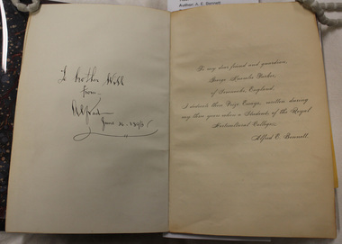
Photograph - Black and white prints and negatives, A.E. Bennett, A.E. Bennett Prize Essays, 1893-1894
Alfred E. Bennett was one of the first students to graduate with a Diploma. He wrote the book after he graduated in 1894. (1) Photographs of photographs, etc. in A.E. Bennett book, "Prize Essays." (i) Acknowledgement for photographs. (ii) p. 101 Appendix. (iii) Diseases of. (iv) Apples. (v) Pioneer timber cottage man and children. (vi) Farm view. (vii) "School of Mines Maryborough. (viii) Group Staff and Students. (ix) "Railway Station Maryborough." (x) "High Street Maryborough." (xi) Maryborough. (xii) Church, Maryborough. (xiii) Maryborough? (xiv) Students and staff seated on horse-drawn cart. (xv, xvi) Distillery equipment. (2) 2 sets of proofs of all photographs in the book. (3) Negatives. Probably taken by A.P. Winzenried for "Green Grows Our Garden." (GGOG). Images used for Media are from B25.0005 as they are the complete collection. Photographs used in GGOG: 26. p9, 11. p10, 25. p12, 5. p22, 19. p29, 15. p32, 27. p 21. The original book is stored with the Burnley Rare Book Collection at the Baillieu Librarya.e. bennett, prize essay, diseases, apples, timber cottage, farm view, school of mines, maryborough, staff, students, railway station, maryborough, church, horse-drawn cart, distillery equipment, a.p. winzenried, green grows our garden, students working outside, orchard, spraying equipment, pruning, planting, orchard gates, entrance gates, neilsons cottage, principal's residence, horticultural board of advice, pavilion, wheelbarrows, californian redwood, sequoia sempervirens, excursion -
 University of Melbourne, Burnley Campus Archives
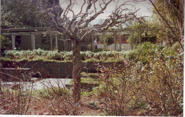
Album - Colour prints and negatives, Garden Views, etc, c. 1991
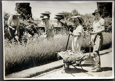
34 colour photographs with negatives. (1) Principal's garage in the Herb Garden area, used for Arboriculture, demolished shortly after in 1992. (2,3)North end of Administration Building. (4) Front of Administration Building. (5,6) Front of Administration Building in winter. (7) ?. (8) Camellia in Emily Gibson Bed. (9) Nursery. (10) Native Garden pool, Andrew Smith, Gardener. (12) Native Garden pool. (13) Melaleuca Lawn. (14)Students outside front of Administration Building. (15-20) Paula Cave, Gardener and Jasmine (in pink) Apprentice working in Herbaceous Border.(21) Students on West side of Administration Building. (22-25) Magnolia in Emily Gibson Bed. (26,27) Pond in a garden not Burnley. (28) Looking through fence to Field Station, Andrew Smith, Gardener. (29) Herbaceous Border and Oak Lawn. (30) Luffmann Ponds and Summer House. (31) Garden view, Wisteria Walk behind. (32) Students in Citriodora Courtyard. (33,34) Students.principal, garage, herb garden, arboriculture, administration building, camellia, emily gibson bed, nursery, native garden, pool, andrew smith, gardener, melaleuca lawn, students, paula cave, gardener, apprentice, herbaceous border, magnolia, ponds, fence, field station, oak lawn, luffmann ponds, summer house, garden views, wisteria walk, citriodora courtyard, lily ponds, orchard -
 University of Melbourne, Burnley Campus Archives
Document - Report, photocopy, Charles Bogue Luffman, Report by the Principal of the School of Horticulture (C. Bogue Luffmann) for the Year Ending 31st December, 1900, 1900
Annual Report by C. Bogue Luffmann, in the Department of Agriculture Annual Report 1900 pp 262-311. 2 copies This is a photocopy of the original report. The report is headed "Department of Agriculture, Victoria." At this time the Burnley School of Agriculture was under the jurisdiction of the Dept. of Agriculture. The report was prepared by the Principal C. Bogue Luffmann. It is 54 pages in length, contains an annual report and prospectus, an examination paper, eight essays on horticultural subjects, 4 of these by Mr Bogue Luffmann and the remainder by students. Essays contained in the Annual Report are: Profitable Branches of Agriculture for Victoria - C Bogue Luffmann (Principal) Trunks and Branches - C Bogue Luffmann Girdling Cincturing Lancing Bandaging & Hardening of Bark - C Bogue Luffmann Humus - Tessa Smith (2nd year student) An examination paper - I Higgins (2nd year student) The Requisite Qualifications of the Commercial Fruit Grower - M.W. Thompson (2nd year student) Fruit Tree Stocks - M.W. Thompson An Examination Paper - H.R. Ward (1st year student) and M. Thatcher (1st year student) charles bogue luffman, principal, student essays, c b luffmann essays, horticulture essays, 1900 horticulture writing, cincturing, girdling, lancing, bandaging horticulture, humus, fruit growing, horticulture turn of the century, horticulture school report, luffmann -
 University of Melbourne, Burnley Campus Archives
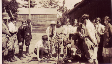
Album - CD black and white and sepia prints, Hilda Dance, 1935-1936
Hilda Dance (graduated 1936, staff 1941-47)2 copies of a CD with photographs taken by Hilda Dance. (1) 4 female students working in a flower bed. (2) 6 students at a flower show. (3) 4 female students on the lawn wearing dresses. (4) Group of students sitting on benches on the lawn. (5) 1936 Year Group. (6) 4 female students playing around on the lawn. (7) Students working near the Luffmann Ponds. (8) Newspaper cutting: 'She knows all the answers.' Student answering questions on a Vegetable Growing public day. (9) 2 female students playing around on the lawn. (10) Possibly an excursion to the zoo-man holding snake. (11) Female student bathing in the Yarra River. (12) Female student climbing a tree with steps cut into it, not Burnley. (13) Students bathing in the Yarra River. (14) 4 female students on the lawn wearing dresses. (15) Group of male students with lawnmower. (16) George Barnett/Russ? (17) Female student watering seedlings. (18) Group of male students with lawnmower. (19) Orchard Border. (20) Group of male students with lawnmower.hilda dance, female students, flower beds, students, flower show, luffmann ponds, students working outside, recreation, lawnmower, tree climbing, george barnett, orchard border, lily ponds