Showing 3209 items
matching engineered
-
 Warrnambool and District Historical Society Inc.
Administrative record - Ledgers (2) - Bruce & McClure, Bruce & McClure business administrators, Petty Cash Book; Share Register, 1916-1945
These two ledgers come from the Warrnambool business of Bruce and McClure. One ledger is a Petty Cash Book with entries dating from 1941 to1945 and the other is a Share Register with entries from 1916 to 1933. The business of Bruce and McClure was located at 159-165 Lava Street Warrnambool and was established about 1900 in premises originally occupied by the plumber and fitter, W. Flett and the blacksmith and farrier, W. Hopkins and in the 1890s by the engineering works of Dobson and Parkinson. Bruce and McClure were engineers, ironfounders and windmill makers and manufactured, produced and serviced farm equipment in a wide area around Warrnambool. In 1945 the business was purchased by the Owen Brothers who later relocated to Caramut Road Warrnambool where it still operates today. These ledgers are of historic interest as they contain details of the operations of an important 20th century business in Warrnambool (Bruce & McClure) and they are very useful for local research. .1 Ledger with a hard green cover and dark red binding. The pages contain red and blue lines and handwritten entries in ink. Some pages are loose and there are some inserts with typed sheets. .2 Ledger with a green cover and dark red binding on the spine. There are alphabetical tabs in the front of the book and the pages contain printed red and blue lines and printed headings. The entries are handwritten in ink. Most of the pages are empty.bruce & mcclure warrnambool, windmill makers warrnambool, owens of warrnambool -
 Eltham District Historical Society Inc
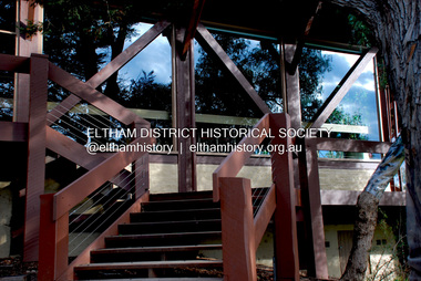
Photograph - Digital Photograph, Jim Connor, Eltham Community and Reception Centre, 801 Main Road, Eltham, 9 July 2008
The Eltham Community and Reception Centre was Australia's first public mud-brick building. Commissioned in 1977 by Eltham Shire Council, led by Shire president (and architect) Robert Marshall, architects Whitford and Peck were asked to design a multipurpose facility in mud-brick and timber. The official opening was performed by the Hon. R.J. Hamer; E.D., M.P., Premier of Victorai on Saturday, April 22, 1978. Architects: Whitford & Peck Pty Ltd Quantity Surveyor: D.J. Cant & Associates Structural Civil Engineers: Charlett & Moore Pty Ltd Landscape: Peter Glass, Dennis Edwards Mech Elec: Lobley Treidel & Partners Pty Ltd Acoustics: Riley Barden & Kirkhope Builder: L.U. Simon Pty Ltdjim connor collection, eltham community and reception centre, eltham community centre, mudbrick construction -
 Warrnambool and District Historical Society Inc.
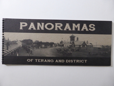
Book, Panoramas of Terang and District, Early 21st century
This is a book containing early 20th century photographs of the town of Terang in the Western District of Victoria. Most of the photographs were taken by Robert Frederick Scott (1877-1953). He was born in Koroit and came to Terang in his early years. He took up coach building and in 1906 he moved to Cobden where he continued coach building with W.J. Silvester. He was regarded at the time as a clever mechanical engineer and was a pioneer in the motor garage business. In the 1930s he was a representative for the Melbourne firm of A.H. McDonald & Co. in the machinery business. He installed milking machines in the Western District and Gippsland. His hobby was photography and he took many photographs in the Western District and supplied photographs to the Victorian Railways for inclusion in the train carriages. This book is of considerable interest as a record of the town of Terang in the early 20th century. The photographs are of high quality and the book will be useful to researchers.This is a soft cover book of 52 pages. It contains black and white photographs of early 20th century Terang and district. The photographs are set in a grey-coloured frame and on the page opposite the photograph is a description of the photograph. The cover is made of lightweight cardboard and the front cover has the title of the book and a black and white photograph of the town of Terang. The book is bound with plastic spirals.history of terang, robert frederick scott, history of western district, warrnambool history -
 Melbourne Water
Photographic View Book, The Melbourne & Metropolitan Board of Works - Water Supply, Sewerage etc. ...Photographic Views, 1908
In 1891 The Melbourne and Metropolitan Board of Works (MMBW) was formed and became responsible for Melbourne's water supply. Melbourne had grown to a city of half a million people. To provide water to this rapidly growing city (especially the eastern suburbs), and to supplement the 1857 Yan Yean Reservoir, Melbourne's first water supply, the Watts River (near Healesville) was tapped. It supplied water to Melbourne, via the Maroondah aqueduct. In May 1892 the MMBW's first engineer-in-chief, Mr William Thwaites began construction on Melbourne's sewerage system. A treatment farm was built at Werribee and a pumping station was built at Spotswood (now the site of the Scienceworks Museum) to send the city's waste to Werribee. The first Melbourne homes were connected to the sewerage system in 1897. This book showcases the MMBW's infrastructure achievements and documents costs, requirements and key personnel involved in the development of the water supply and sewerage schemes.The introduction states "The water supply sources and headworks are in many cases situated in remote places and the sewerage works are chiefly underground. The Board has therefore resolved that these photographs of some of the scenes and works should be collected and bound for general information. August 1908" This book is in excellent condition and provides a detailed insight into the previous 17 years of work and the Board personnel of the MMBW leading up to 1908. It is of historical importance to the history of Melbourne for the photographic documents of places that were not generally open to the public, and for Melbourne Water in its detailed history of the MMBW in the early twentieth century. Photographic view book with hard khaki coloured cardboard cover and blue fabric binding. 120 Pages. Glossy paper with black and white plates and text about the MMBW, and scenic views and places of interest in association with the MMBW. The Melbourne & Metropolitan Board of Works - Water Supply, Sewerage etc. ...Photographic Views...mmbw, board members, sewerage, water supply, historic views, photographs -
 Surrey Hills Historical Society Collection
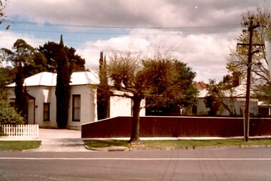
Photograph, Merthyr - 64 Windsor Crescent, Surrey Hills, 1988, 1988
Ref: Alan Holt records - This property was part of Lot 25 in the Windsor Park Estate which was subdivided in 1883. The house of 12 squares was built in 1888 for John Abernethy, an engineer. He also built 62 Windsor Crescent as a coachhouse and cottage. 1888-1891: Owners = John & Sarah Abernethy. John Abernethy died while on a trip to Hong Kong in 1891. 1891-1909: Owner = Mrs Sarah Abernethy 1910-1917: Owner = H Jenkinson The properties at 62 and 64 Windsor Crescent were separated during WW1 (by H Jenkinson). See Alan Holt records for other short term owners. 1970-1975 = Plymouth Bretheren Meeting Hall In 1976 it became a private home again.This is one of the earliest surviving houses in Surrey Hills.A colour photo taken from the street at the rear of a Victorian-style house with rendered walls and a slate roof. The house sits behind a timber fence.victorian style, windsor park estate, merthyr, plymouth bretheren meeting hall, mr john abernethy, mrs sarah abernethy, mr h jenkinson, surrey hills -
 Phillip Island Conservation Society Inc.
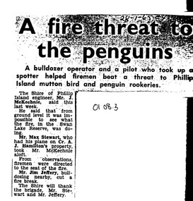
Work on paper - Photocopy of newspaper cutting, Wonthaggi Express or Powlett Express newspaper, "A fire threat to/the penguins", 28.01.1965
The article describes a fire incident which took place in January 1965 at Swan Lake, a water reserve at the entrance to Summerland Peninsula, Phillip Island. Due to an extremely heavy infestation of gorse (noxious weed) and natural tea tree scrub, along with poor vehicle access, the volunteer fire fighters could apparently not gauge the extent of the fire. A light plane operator visiting Cr Arthur Hamilton nearby was able to fly Phillip Island Shire Engineer, Jock McKechnie, over the lake to better direct the fire fighters. Swan Lake has many Bunurong Aboriginal middens and short-tailed shearwater rookeries, and, being not far from the Penguin Parade, a fire there posed a direct threat to the birds. The article is significant because it indicates the vulnerability of the Summerland Peninsula reserves to fire, the way the Shire Engineer, local bulldozer contractor and volunteer fire fighters tackled the fire outbreak. photocopy of newspaper cutting. Dark copying at top. Double column heading. Single column black text on white paper28-1-65 EXswan lake phillip island, summerland peninsula, bunurong aboriginal middens, short-tailed shearwaters, mutton birds, little pengiuns, penguin parade, jock mckechnie, cr arthur hamilton, fire fighters, , max stewart, jim jeffery -
 Melbourne Tram Museum
Photograph - Black and White - cable tram lighting battery workers
Photograph shows a group of five cable tramway employees with a cart containing batteries to supply power for lights in Melbourne Cable trams. This lighting was introduced by the Tramway Board (TB), the forerunner to the MMTB during 1917. A motor generator at each car house or depot provided the power to charge the batteries which were then placed in each tram for the day. Reference - The Commonwealth Engineer 1/8/1917 - Reg Item 2568. The equipment was provided by the General Electric Company. The cart has the letters "TB CH" possibly indicating Clifton Hill Depot and the batteries are lettered "NE" and then given a number. Photo date unknown - 1917 to 1940. This photograph is Public Records Office photo H84 in the Victorian Railways collection.Yields information about the type of batteries used to provide lighting power to cable trams and the workers involved and their clothing. Photograph - Black and White of a group of 5 cable tram battery workers and their cart.trams, tramways, cable trams, lights, depots, car houses, general electric, batteries, clifton hill, tramway board -
 Melbourne Tram Museum
Administrative record - Annual Report/s, Footscray Tramway Trust, "Footscray Tramway Trust", 1917
First Annual Report of the Footscray Tramway Trust, for the year ending 30/9/1917. Lists the Trust Members, Consulting Engineers, and Secretary. Details the Trust's activities, financial loans, construction, car barn, and that it is the first Australian Tramway to use Australian-made rails. Engineering report by McCarty Underwood lists the lines to be built, and rails to use an 80lb/yard NSW railway section with a 30lb/yard bolt-on check rail. Notes the intention to have 7 one-man-operated cars and 3 combination cars. Gives expected cost of operations. Lists the Footscray Council Officers that were involved in the project. Supplementary letter from McCarty Underwood about the cost of the rails and the composite section dated 15/11/1917. Yields information about the construction of the Footscray Tramway Trust tramways.Ten foolscap sheets, duplicated, stapled in top left hand corner.tramways, tramcars, ftt, footscray tramways trust, new tramways, rails, tramway construction, annual reports -
 Bendigo Military Museum
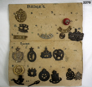
Badge - BADGE COLLECTION MOUNTED, C.WW2
Items in the collection re Ian McLeod RWAFF, refer Cat No 2262.2 for service details.Panel One only, a lot of Indian badges. .1) RAF badge .2), .3), .4) .6) missing .5) SAFA 11 SAVA .7) Derby .8) RSAP .9) SJAB .10) Gloucestershire, Eygpt with Lion .11) Eygpt, Lion, Surronded by oak leaf cluster .12) Red button badge, with a bugle and K R motif over it Panel Two .1) Circular badge .2) Indian signals corps badge. oval shape surmounted with 5 pointed star .3) Indian reconaisance corp badge symbolic tree and arrow .4) Indian engineers badge. 5 point star surrounded by oak leaf cluster .5) Missing .6) WAC India .7) Indian intelligence corps. 5 pointed star .8) Indian electrical and mechanical engineers badge .9) Indian army ordinance badge .10) Indian army medical corps .11) Symbolic cross .12) Burma intelligence corps .13) Stylised trench raid weapon Panel Three .1) Crossed khukris .2) Cross khukris .3) Simple doughnut shaped ring .4) Doughnut shaped ring. surmounted by a crown in center is letters X1 .5) JAT Regiment badge large letters IX surmounted with a crown .6) Regiment cluster of leaves .7) Madras regiment badge .8) Unknown 4 sort of legs surrounded with a crown .9) Dogras Regt. In the centre are the number 17 surmounted with a crown .10) Punjab regt. Center is a 5 pointed star with numbers 14 surmounted with a crown .11) Missingbadges, collection, indian -
 The Beechworth Burke Museum
Photograph, 1960s
This photograph was taken in the 1960s at Lake Sambell Caravan Park and visible in the photograph are individual caravan sites with electricity outlets, a large single-story building with a caravan park banner, dirt roads, a freestanding message board, and a parked car. Lake Sambell Caravan Park opened in 1959 owing to the work of R.E. Carter, Beechworth Shire engineer from 1954-63. Carter advocated for improvements to the lake and surrounding area in order to encourage tourism in Beechworth. The opening of the caravan park was part of many improvements to Lake Sambell made in this period by Carter including: the swimming pool in 1961, water skiing and boating facilities, and increased lake surface in 1964. These improvements were financed mainly by grants from the Tourist Development Authority. The popularity of caravanning in Australia exploded during this post-war period of the late 1950s and 1960s. This popularity was driven by multiple factors, including: the stopping of fuel rations, the accessibility of car ownership through the manufacturing of affordable cars, technological developments in caravan design, and the increase in prosperity and leisure time for many Australians. Facilities such as electrical outlets to power caravans are present in this photograph of Lake Sambell Caravan Park. Lake Sambell is an artificial lake that was developed on the previous site of the Rocky Mountain Mining Company workings and was officially opened by Minister for Lands, Mr Baily, on October 5, 1928. The disused and unattractive remains of the mine were converted into a recreational area intended for swimming, boating, and fishing. The lake is named after Mr L.H. Sambell, shire engineer and secretary of the Forward Beechworth Committee, who advocated for the enhancement of Beechworth into a tourist destination and was central to the planning and establishment of the lake. This photograph is of historical and social significance in providing insight into caravanning during the 1960s in Australia. Caravanning was extremely popular during the 1960s in Australia due to multiple social and economic factors including the stopping of fuel rations, the accessibility of car ownership through the manufacturing of affordable cars, technological developments in caravan design, and the increase in prosperity and leisure time for many Australians.Black and white rectangle photograph printed on photographic paper and unmounted.Reverse: 3536/ [logo back printing: KODAK/ VELOX/ PAPER] / C798 lake sambell caravan park, lake sambell, caravanning 1960s, caravan park, rocky mountain mining company, kodak velox paper, r.e. carter, l.h. sambell, caravan electricity outlets, tourist development authority, post-war prosperity, forward beechworth committee, lake sambell boating, lake sambell swimming pool, lake sambell fishing, artificial lake, travel 1960s, recreation 1960s -
 The Beechworth Burke Museum
Photograph, 1960s
This photograph was taken in the 1960s at Lake Sambell Caravan Park, visible in the photograph are individual caravan sites with electricity outlets, a large single-story building, a parked car, and two caravans partially obstructed by trees. Lake Sambell Caravan Park opened in 1959 owing to the work of R.E. Carter, Beechworth Shire engineer from 1954-63. Carter advocated for improvements to the lake and surrounding area in order to encourage tourism in Beechworth. The opening of the caravan park was part of many improvements to Lake Sambell made in this period by Carter including: the swimming pool in 1961, water skiing and boating facilities, and increased lake surface in 1964. These improvements were financed mainly by grants from the Tourist Development Authority. The popularity of caravanning in Australia exploded during this post-war period of the late 1950s and 1960s. This popularity was driven by multiple factors, including: the stopping of fuel rations, the accessibility of car ownership through the manufacturing of affordable cars, technological developments in caravan design, and the increase in prosperity and leisure time for many Australians. Facilities such as electrical outlets to power caravans are present in this photograph of Lake Sambell Caravan Park. Lake Sambell is an artificial lake that was developed on the previous site of the Rocky Mountain Mining Company workings and was officially opened by Minister for Lands, Mr Baily, on October 5, 1928. The disused and unattractive remains of the mine were converted into a recreational area intended for swimming, boating, and fishing. The lake is named after Mr L.H. Sambell, shire engineer and secretary of the Forward Beechworth Committee, who advocated for the enhancement of Beechworth into a tourist destination and was central to the planning and establishment of the lake. This photograph is of historic and social significance in documenting the enhancement of the Lake Sambell area overseen by R.E. Carter and providing insight into caravanning during the 1960s in Australia. Caravanning was extremely popular in Australia during the late 1950s and 60s due to multiple social and economic factors including the stopping of fuel rations, the accessibility of car ownership through the manufacturing of affordable cars, technological developments in caravan design, and the increase in prosperity and leisure time for many Australians. Black and white rectangle photograph printed on photographic paper and unmounted.Reverse: 3538/ [logo back printing KODAK/ VELOX/ PAPER] / C798lake sambell caravan park, lake sambell, lake sambell 1960s, lake sambell fishing, lake sambell boating, lake sambell swimming pool, r.e. carter, l.h. sambell, tourist development authority, caravanning 1960s, caravan electricity outlets, caravan park, forward beechworth committee, rocky mountain mining company, lake caravan park, caravan mid 20th century, beechworth tourism, travel in the 1960s, holiday 1960s -
 Bendigo Military Museum
Booklet - A survey of the North Australian Coast on AK121 Aroetta, NT Force, NT Coastal Recce Unit RAE, 6 Aust Army Topo Survey Corps, AKA121 Aroetta, 28 Mar 1945
The work of the Australian Survey Corps is to make maps for the Army. At the outbreak of war very little of the mainland had been mapped, especially the northern parts. The best maps in existence of the N.T. coast in Dec "41 were those made by Matt Flinders in 1801 -1802. The Army soon got out new maps of all important areas including much of the inland. Later it was decided to bring the complete coastline up to date. Several parties put in between them six months on the coast during the dry season of "45 but a couple more months would be needed to complete the program when the "wet" interrupted the work. A small section from Buckingham Bay - Groote Eylandt was still untouched and this diary covers that section of the N.T. Coast. A survey party of four men was chosen who were to be transported from place to place by the AK121 Aroetta - a ketch of 25 tons belonging to an army unit called N.T. Coastal Recce whose work it was to patrol the coast and as well do air - sea rescue. The survey party: Lieut Jack Worsley (the Loot) Sgt jack Love, Spr Jack Cook, Spr Pat Hede. Crew of Aroetta: Liet Ralph Warne (Skipper), Sgt Buckley (Buck) (First Mate and Ordly Rm), Sgt Jim Terjesen (Jumbo) Bosun, WO2 Tom Davis (Engineer), Cpl Kevin Monk (Artificer), L/Cpl Jack Cox (Deck Hand), Spr Jack Andrews (Signals), Spr Laurie Rament (Ass. Engineer), Spr McKenzie (Mac) (Cook). The complete history is not available after July 31 1945. The remainder of the notes are very badly water-damaged and in some places unreadable.A4 Booklet, plain paper with text and diagrams and half tone photograph of Lt Jack Worsley with plastic binderSigned by George Barton Maj. for LtCol GS. NT Forceroyal australian survey corps, rasvy, fortuna, army survey regiment, army svy regt, asr -
 Australian Gliding Museum
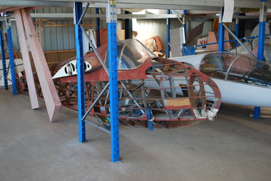
Machine - Glider – Sailplane, 1972
The Hall Cherokee II glider is an American design for amateur construction from plans. The designer was Stan Hall (1915-2009), a professional engineer, who gained extensive experience in the United States aviation industry during World War 2 including the programs for military gliders. He continued to work as an engineer for aircraft manufacturers and as a consultant to the industry after the war. He was active in gliding and, in particular, the home built sailplane movement. The Cherokee II was one of about 10 glider designs that he produced: it came out in 1956. It is understood that over 100 Cherokee gliders have been built. In Australia the number is possibly 10 or 11. The Hall Cherokee VH-GVO was built by R.D Meares of Caringbah, New South Wales. The glider was registered as VH-GVO on 11 October 1973 and given serial number “GFA-HB-82” by the Gliding Federation of Australia. The Logbook for VH-GVO appears to be a complete record of the flying history; in aggregate 210 hours 40 minutes in the air from 331 flights. The first test hop occurred on 29 July 1972 at Camden, New South Wales. VH-GVO was last flown on 22 July 1986. Many of the flights recorded are of one or two hours duration. The glider was last inspected and certified as airworthy and in a reasonable condition at the Hunter Valley Gliding Club in July 1986. Since that time, until transferred to the Australian Gliding Museum, the glider was in storage. Structural restoration work has been completed on the fuselage and one wing. However, inspection of the other wing revealed extensive damage to the ribs and spars and consequently a decision was taken to make it a static exhibit. The exhibit is an example of home built construction of a type that has proved popular amongst amateur glider builders.The Hall Cherokee (formerly registered as VH-GVO) is a single seat wooden home built glider. The glider is constructed from wood, plywood, fabric and metal fittings, all commercial grade except for main wing fittings, pulleys, cables and bolts. The fuselage is simple with four main longerons and bulkheads with diagonal bracing. The wing has two identical solid spars which form a geodetic structure, hence the leading edge is non-structural. Registration VH-GVO – serial number GFA-HB-82 australian gliding, glider, sailplane, hall, cherokee, meares, hunter valley gliding club -
The Ed Muirhead Physics Museum
MILLIONAIRE (#2) 10 keys
Plaque: ‘Hans W Egli/Ingenieur / Fabrikation von flechenmashinen [sic; ?] / Pat. O, Steiger / Zurich II / No 2566. Sole Agents for Australia / Peacock Bros./ Business Systems Company / 558 , 560, 562 Collins St., Melbourne / and at / Sydney, Adelaide, Perth’ Plaque: ‘Presented to . / Department of Information Science / Melbourne University / by the / Gas & Fuel Corporation of Victoria / This calculating machine was used by Engineers of the Metropolitan Gas Co and Gas & Fuel Corporation / from 1917 to 1970’ -
 Rutherglen Historical Society
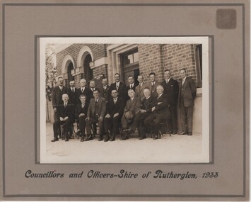
Photograph, 1933 (Exact)
Rutherglen Shire CouncilPhotograph of shire councillors in front of shire office 1933On bottom of frame beneath photo: "Councillors and Officers - Rutherglen Shire, 1933" On verso: "Back row / Crs. J.L. Jackson, S.P. Diffey, Walter McRae, Percy Lingford (Engineer), S.G. Williams, J. Milthorpe, C. Ricketts (Shire Secretary), L. Tobbon, J. Terril, W.B. McDonald, W. H. Turner (Rutherglen Sun)" "Front row / John Burch, Roy Ready, CH. Morris, Frank Fuge, D.B. Smith, Martin Graham, W.H. Chambers"j l jackson, s p diffey, walter mcrae, percy lingford, s g williams, j milthorpe, c ricketts, l tobbon, j terril, w b mcdonald, w h turner, john burch, roy ready, c h morris, frank fuge, d b smith, martin graham, w h chambers -
 Kiewa Valley Historical Society
Photo - Bogong Township, March 1944
In 1940 Field Headquarters for the Kiewa Scheme were established at Bogong with office, workshop facilities and accommodation for workmen, staff and some families constructed. (There had been a 'tent camp' on this site in 1939 but was destroyed by bushfires) Construction of accommodation continued until 1947. A total of 40 houses plus a hostel for single staff, post office, police station, medical centre and primary school all with water and sewerage and electricity supply. The staff hostel was known as Kiewa House and is now occupied by the Education Department. Lake Guy was named after Mr. L.T. Guy who was the Resident Engineer in charge of construction work and associated activities on the Kiewa area. He held this position from 1939 to November 1946 when he was transferred to Head Office. The Bogong Township was developed firstly as an accommodation centre (base camp) for construction workers employed under the Kiewa Hydroelectric Scheme. Due to the influx of European workers into the Township the beautification of the immediate surrounds (gardens etc.) had a distinct European flavour. This environment has been very beneficial for tourism in later years. At the completion of the scheme, in the 1960's, the village was opened to public/tourism use. Strict environmental control has not allowed for any extensive redevelopment in tourist accommodation and basically restricted it to the accommodation initially built for the construction workers. Activities such a bike riding, snow skiing, restricted horse riding and bush walking on the Alpine plains and mountains are now a viable part of the Kiewa Valley Tourist Industry. The lake is one of the many water storage reservoirs used to supply the power stations their main power to run the huge turbines generating the final product, electricityBlack and white photograph of Bogong Township taken March 1944Handwritten on the back of photo - Township March '44bogong village, secv -
 Kiewa Valley Historical Society
Photograph - Bogong Village (7 copies), Approx 1940
In 1940 Field Headquarters for the Kiewa Scheme were established at Bogong with office, workshop facilities and accommodation for workmen, staff and some families constructed. (There had been a 'tent camp' on this site in 1939 but was destroyed by bushfires) Construction of accommodation continued until 1947. A total of 40 houses plus a hostel for single staff, post office, police station, medical centre and primary school all with water and sewerage and electricity supply. The staff hostel was known as Kiewa House and is now occupied by the Education Department. Lake Guy was named after Mr. L.T. Guy who was the Resident Engineer in charge of construction work and associated activities on the Kiewa area. He held this position from 1939 to November 1946 when he was transferred to Head Office. The Bogong Township was developed firstly as an accommodation centre (base camp) for construction workers employed under the Kiewa Hydroelectric Scheme. Due to the influx of European workers into the Township the beautification of the immediate surrounds (gardens etc.) had a distinct European flavour. This environment has been very beneficial for tourism in later years. At the completion of the scheme, in the 1960's, the village was opened to public/tourism use. Strict environmental control has not allowed for any extensive redevelopment in tourist accommodation and basically restricted it to the accommodation initially built for the construction workers. Activities such a bike riding, snow skiing, restricted horse riding and bush walking on the Alpine plains and mountains are now a viable part of the Kiewa Valley Tourist Industry. The lake is one of the many water storage reservoirs used to supply the power stations their main power to run the huge turbines generating the final product, electricity. Evidence can be seen of the 1939 bushfires.Set of 7 identical black and white photographs of Bogong Village after 1939 bush firesHandwritten on the back of one photo - Bogong Village approx. 1940, after 1939 bush fires. Staff residences to left. Kiewa House, General offices and test lab to the right. Hand drawn map on the back of one photo.bogong village, secv -
 Kiewa Valley Historical Society
Photo - Bogong Village Township, October 8, 1946
In 1940 Field Headquarters for the Kiewa Scheme were established at Bogong with office, workshop facilities and accommodation for workmen, staff and some families constructed. (There had been a 'tent camp' on this site in 1939 but was destroyed by bushfires) Construction of accommodation continued until 1947. A total of 40 houses plus a hostel for single staff, post office, police station, medical centre and primary school all with water and sewerage and electricity supply. The staff hostel was known as Kiewa House and is now occupied by the Education Department. Lake Guy was named after Mr. L.T. Guy who was the Resident Engineer in charge of construction work and associated activities on the Kiewa area. He held this position from 1939 to November 1946 when he was transferred to Head Office. The Bogong Township was developed firstly as an accommodation centre (base camp) for construction workers employed under the Kiewa Hydroelectric Scheme. Due to the influx of European workers into the Township the beautification of the immediate surrounds (gardens etc.) had a distinct European flavour. This environment has been very beneficial for tourism in later years. At the completion of the scheme, in the 1960's, the village was opened to public/tourism use. Strict environmental control has not allowed for any extensive redevelopment in tourist accommodation and basically restricted it to the accommodation initially built for the construction workers. Activities such a bike riding, snow skiing, restricted horse riding and bush walking on the Alpine plains and mountains are now a viable part of the Kiewa Valley Tourist Industry. The lake is one of the many water storage reservoirs used to supply the power stations their main power to run the huge turbines generating the final product, electricityBlack and white photograph of Bogong Village which appeared in the Herald Sun newspaper on October 8, 1946. Page 13Handwritten on the back - Town of Bogong on a rugged mountain slope above Lake Guy. State Electricity Committee workers on the Kiewa Hydro Electric scheme live here in all electric homes. Stamped on the back - Copyright Not for reproduction Herald Sun Feature Service Melbourne Australiabogong village; lake guy; kiewa hydro electric scheme -
 Kiewa Valley Historical Society
Postcard - Lake Guy and Bogong Village
In 1940 Field Headquarters for the Kiewa Scheme were established at Bogong with office, workshop facilities and accommodation for workmen, staff and some families constructed. (There had been a 'tent camp' on this site in 1939 but was destroyed by bushfires) Construction of accommodation continued until 1947. A total of 40 houses plus a hostel for single staff, post office, police station, medical centre and primary school all with water and sewerage and electricity supply. The staff hostel was known as Kiewa House and is now occupied by the Education Department. Lake Guy was named after Mr. L.T. Guy who was the Resident Engineer in charge of construction work and associated activities on the Kiewa area. He held this position from 1939 to November 1946 when he was transferred to Head Office. The Bogong Township was developed firstly as an accommodation centre (base camp) for construction workers employed under the Kiewa Hydroelectric Scheme. Due to the influx of European workers into the Township the beautification of the immediate surrounds (gardens etc.) had a distinct European flavour. This environment has been very beneficial for tourism in later years. At the completion of the scheme, in the 1960's, the village was opened to public/tourism use. Strict environmental control has not allowed for any extensive redevelopment in tourist accommodation and basically restricted it to the accommodation initially built for the construction workers. Activities such a bike riding, snow skiing, restricted horse riding and bush walking on the Alpine plains and mountains are now a viable part of the Kiewa Valley Tourist Industry. The lake is one of the many water storage reservoirs used to supply the power stations their main power to run the huge turbines generating the final product, electricityBlack and white photographic postcard of Lake Guy and Bogong Village. Kiewa Hydro electric Project (showing Junction Dam in front)Handwritten on the back of postcard ' Like most of our camps, this looks like something from the Canadian Rockies' Stamped on the back - Valentine's Post Card A genuine photographlake guy, bogong village, secv -
 Kiewa Valley Historical Society
Photo - Bogong Township, September 1953
In 1940 Field Headquarters for the Kiewa Scheme were established at Bogong with office, workshop facilities and accommodation for workmen, staff and some families constructed. (There had been a 'tent camp' on this site in 1939 but was destroyed by bushfires) Construction of accommodation continued until 1947. A total of 40 houses plus a hostel for single staff, post office, police station, medical centre and primary school all with water and sewerage and electricity supply. The staff hostel was known as Kiewa House and is now occupied by the Education Department. Lake Guy was named after Mr. L.T. Guy who was the Resident Engineer in charge of construction work and associated activities on the Kiewa area. He held this position from 1939 to November 1946 when he was transferred to Head Office. The Bogong Township was developed firstly as an accommodation centre (base camp) for construction workers employed under the Kiewa Hydroelectric Scheme. Due to the influx of European workers into the Township the beautification of the immediate surrounds (gardens etc.) had a distinct European flavour. This environment has been very beneficial for tourism in later years. At the completion of the scheme, in the 1960's, the village was opened to public/tourism use. Strict environmental control has not allowed for any extensive redevelopment in tourist accommodation and basically restricted it to the accommodation initially built for the construction workers. Activities such a bike riding, snow skiing, restricted horse riding and bush walking on the Alpine plains and mountains are now a viable part of the Kiewa Valley Tourist Industry. The lake is one of the many water storage reservoirs used to supply the power stations their main power to run the huge turbines generating the final product, electricityBlack and white photograph of Bogong Township taken from Little Arthur fire track. September 1953Faded handwritten inscription on back - Bogong Township taken from Little Arthur fire track. Sept 1953bogong village, secv -
 Kiewa Valley Historical Society
Photo - First Bogong Camp, September 1950
In 1940 Field Headquarters for the Kiewa Scheme were established at Bogong with office, workshop facilities and accommodation for workmen, staff and some families constructed. (There had been a 'tent camp' on this site in 1939 but was destroyed by bushfires) Construction of accommodation continued until 1947. A total of 40 houses plus a hostel for single staff, post office, police station, medical centre and primary school all with water and sewerage and electricity supply. The staff hostel was known as Kiewa House and is now occupied by the Education Department. Lake Guy was named after Mr. L.T. Guy who was the Resident Engineer in charge of construction work and associated activities on the Kiewa area. He held this position from 1939 to November 1946 when he was transferred to Head Office. The Bogong Township was developed firstly as an accommodation centre (base camp) for construction workers employed under the Kiewa Hydroelectric Scheme. Due to the influx of European workers into the Township the beautification of the immediate surrounds (gardens etc.) had a distinct European flavour. This environment has been very beneficial for tourism in later years. At the completion of the scheme, in the 1960's, the village was opened to public/tourism use. Strict environmental control has not allowed for any extensive redevelopment in tourist accommodation and basically restricted it to the accommodation initially built for the construction workers. Activities such a bike riding, snow skiing, restricted horse riding and bush walking on the Alpine plains and mountains are now a viable part of the Kiewa Valley Tourist Industry. The lake is one of the many water storage reservoirs used to supply the power stations their main power to run the huge turbines generating the final product, electricityBlack and white photo of Bogong Village. September 1950Handwritten on the back - 1st Bogong Camp. SEC Kiewa Scheme Sept 1950bogong camp, bogong village, secv -
 Kiewa Valley Historical Society
Photo - Bogong Village Township
In 1940 Field Headquarters for the Kiewa Scheme were established at Bogong with office, workshop facilities and accommodation for workmen, staff and some families constructed. (There had been a 'tent camp' on this site in 1939 but was destroyed by bushfires) Construction of accommodation continued until 1947. A total of 40 houses plus a hostel for single staff, post office, police station, medical centre and primary school all with water and sewerage and electricity supply. The staff hostel was known as Kiewa House and is now occupied by the Education Department. Lake Guy was named after Mr. L.T. Guy who was the Resident Engineer in charge of construction work and associated activities on the Kiewa area. He held this position from 1939 to November 1946 when he was transferred to Head Office. The Bogong Township was developed firstly as an accommodation centre (base camp) for construction workers employed under the Kiewa Hydroelectric Scheme. Due to the influx of European workers into the Township the beautification of the immediate surrounds (gardens etc.) had a distinct European flavour. This environment has been very beneficial for tourism in later years. At the completion of the scheme, in the 1960's, the village was opened to public/tourism use. Strict environmental control has not allowed for any extensive redevelopment in tourist accommodation and basically restricted it to the accommodation initially built for the construction workers. Activities such a bike riding, snow skiing, restricted horse riding and bush walking on the Alpine plains and mountains are now a viable part of the Kiewa Valley Tourist Industry. The lake is one of the many water storage reservoirs used to supply the power stations their main power to run the huge turbines generating the final product, electricityBlack and white photograph of Bogong Village from across Lake Guy. Photo mounted on buff cardbogong village, secv -
 Kiewa Valley Historical Society
Photograph – Set of 3 black and white photographs of Bogong Village circa late 1930's - 1940's during early construction of Lake Guy ( in the foreground), Late 1930's - 1940's
In 1940 Field Headquarters for the Kiewa Scheme were established at Bogong with office, workshop facilities and accommodation for workmen, staff and some families constructed. (There had been a 'tent camp' on this site in 1939 but was destroyed by bush fires) Construction of accommodation continued until 1947. A total of 40 houses plus a hostel for single staff, post office, police station, medical centre and primary school all with water and sewerage and electricity supply. The staff hostel was known as Kiewa House and is now occupied by the Education Department. Lake Guy was named after Mr. L.T. Guy who was the Resident Engineer in charge of construction work and associated activities on the Kiewa area. He held this position from 1939 to November 1946 when he was transferred to Head Office. The Bogong Township was developed firstly as an accommodation centre (base camp) for construction workers employed under the Kiewa Hydroelectric Scheme. Due to the influx of European workers into the Township the beautification of the immediate surrounds (gardens etc.) had a distinct European flavour. This environment has been very beneficial for tourism in later years. At the completion of the scheme, in the 1960's, the village was opened to public/tourism use. Strict environmental control has not allowed for any extensive redevelopment in tourist accommodation and basically restricted it to the accommodation initially built for the construction workers. Activities such a bike riding, snow skiing, restricted horse riding and bush walking on the Alpine plains and mountains are now a viable part of the Kiewa Valley Tourist Industry. The lake is one of the many water storage reservoirs used to supply the power stations their main power to run the huge turbines generating the final product, electricity3 black and white photographs of the Bogong camp area showing the clearing of trees for the construction of the Junction Dam and Lake Guy. Some administration buildings have been constructed, but part of the tent camp can be seen to the right of the photograph in front of the buildings. bogong village; junction dam; lake guy; kiewa hydro electric scheme; secv -
 Kiewa Valley Historical Society
Photograph from Lake Guy, Bogong Village, Scene from shores of Lake Guy to Mountain range, 1930s to 1950s
In 1940 Field Headquarters for the Kiewa Scheme were established at Bogong with office, workshop facilities and accommodation for workmen, staff and some families constructed. (There had been a 'tent camp' on this site in 1939 but was destroyed by bushfires) Construction of accommodation continued until 1947. A total of 40 houses plus a hostel for single staff, post office, police station, medical centre and primary school all with water and sewerage and electricity supply. The staff hostel was known as Kiewa House and is now occupied by the Education Department. Lake Guy was named after Mr. L.T. Guy who was the Resident Engineer in charge of construction work and associated activities on the Kiewa area. He held this position from 1939 to November 1946 when he was transferred to Head Office.The Bogong Township was developed firstly as an accommodation centre (base camp) for construction workers employed under the Kiewa Hydroelectric Scheme. Due to the influx of European workers into the Township the beautification of the immediate surrounds(gardens etc.) had a distinct European flavour. This environment has been very beneficial for tourism in later years. Strict environmental control has not allowed for any extensive redevelopment in tourist accommodation and basically restricted it to the accommodation initially built for the construction workers. Activities such a bike riding, snow skiing, restricted horse riding and bush walking on the Alpine plains and mountains are now a viable part of the Kiewa Valley Tourist Industry. The lake is one of the many water storage storage reservoirs used to supply the power stations their main power to run the huge turbines generating the final product, electricityThis black and white photograph shot from the shores of Lake Guy toward the mountain range of the Victorian Alps details the early construction of the construction worker's accommodation of the Bogong Village. The paper is of 200gms and is not photographic paper and can be assumed to be a reproduction of an original photobogong village circa 1930 to 1950, kiewa hydro-electricity scheme, victorian alpine region mid 1900s -
 Kiewa Valley Historical Society
Photograph of Lake Guy and Bogong Village, Lake Guy and Bogong Village, Approx. 1945
In 1940 Field Headquarters for the Kiewa Scheme were established at Bogong with office, workshop facilities and accommodation for workmen, staff and some families constructed. (There had been a 'tent camp' on this site in 1939 but was destroyed by bushfires) Construction of accommodation continued until 1947. A total of 40 houses plus a hostel for single staff, post office, police station, medical centre and primary school all with water and sewerage and electricity supply. The staff hostel was known as Kiewa House and is now occupied by the Education Department. Lake Guy was named after Mr. L.T. Guy who was the Resident Engineer in charge of construction work and associated activities on the Kiewa area. He held this position from 1939 to November 1946 when he was transferred to Head Office.This photograph is an excellent historical record of Bogong Village in about 1945. It shows the layout of the town in the fairly steep terrain, the workmen's camp between the houses and the lake foreshore, the Commissioner's Lodge on the hill behind the Village, the walkway through the dam wall can be seen to the left of the spillway, the dam is on spill and note damage to the large trees is still evident from the 1939 bush fires. The Commissioner's Lodge was lost in the 2003 fires and the camp buildings were in service until 1962, when they were removed and the site converted into a public picnic area with lawns and gardens.A Black and white photograph"Lake Guy and Bogong" hand written on back of photograph.kiewa, accommodation, lake, dam, bogong -
 Orbost & District Historical Society
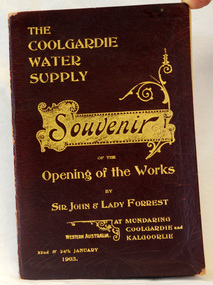
program, The Coolgardie Water Supply, 1903
This program belonged to Dr James Kerr. Conceived by Engineer-in-Chief C.Y. O’Connor and completed in 1903, the Coolgardie Goldfields Water Supply Scheme comprised a reservoir on the Helena River, eight steam-driven pumping stations and 566 kilometres of steel pipeline supplying 23,000 kilolitres of water daily to the arid goldfields of Western Australia. The project was officially opened by Sir John and Lady Forrest in January 1903. "Great pomp and ceremony heralded the arrival of water and the opening of the Scheme. Clean, fresh water could now be easily obtained in some of Australia's harshest country. However, this victory came at a great cost. The stress of the bold project was too much for O’Connor, who, after enduring endless criticism, took his life on 10 March 1902, before the Scheme was completed." - Western Australian Museum : The Coolgardie Goldfields Water Supply Scheme was an ambitious engineering feat because at the time water had never been lifted so high nor pumped so far (about 560 km). The Scheme, which pumps water from the better-watered coastal area, operates to this day. This item is associated with an historic event in the history of opening up arid areas of Australia to settlement. The item is associated with Dr James Kerr, the first doctor to settle in Orbost.A souvenir program from the opening of the works of the Coolgardie Water Supply. It has a maroon cover with gold print. Details include the date and place.coolgardie-water-supply western-australia-goldfields -
 City of Moorabbin Historical Society (Operating the Box Cottage Museum)
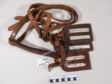
Leather, luggage straps and labels c1916, 20thC
Leather straps were commonly used to secure cases and other forms of luggage when traveling. The labels enabled easy identification when collecting luggage from transport carriages, coaches, buses and trains. 10th Field Company, Australian Engineers WW1 1914-18. The 10th Brigade was an infantry brigade of the Australian Army. Originally formed in 1912 as a Militia formation, the brigade was re-raised in 1916 as part of the expansion of the Australian Imperial Force following the end of the Gallipoli campaign. It subsequently saw service on the Western Front in France and Belgium during the First World War. After the war it was disbanded but was re-raised in 1921 as a part-time formation based in the state of Victoria. During the Second World War the brigade was used in a garrison role in Australia before being disbanded in 1942.These leather straps and labels were attached to the luggage of an Australian soldier during early 20th C who may have been a resident or relative of a resident in City of MoorabbinLeather luggage straps with metal buckles and 3 luggage address labels attached.Label 1 - L.D.McCallum Sgt / 10th Fd Coy AE Label 2 - Healesville Label 3 - Maryborough leather, straps, belts, luggage labels, tools, saddles, wallets, personal effects, horses, drays, world war 1 1914 -18, world war 2 1939-45, army, 1st aif, military, 10th field company australian engineers, western front, france, belgium, -
 Churchill Island Heritage Farm
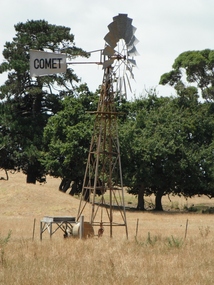
Functional object - Comet Windmill, 1930s
Comet Windmills was founded in Rockhampton, Queensland in 1879 by Sidney Williams. The Comet became known as "Australia's Leading Mill". The company survived two world wars and three generations of the family and was sold in 1992 and terminated in 1998. The windmill is a vital farming tool as it assists with agriculture, irrigation, and water supply. This windmill drew water from the 'Windmill Dam' for decades before Churchill Island's acquisition by Victorian Conservation Trust in 1976. In 1981, VCT invited BP Westernport Refinery Manager, John Shawley, to inspect the windmill with view of restoration. This was then done through the next year, as BP Social Club Members (including engineers, managers, and accountants) restored the pump, wheel, tower and piping. The wheel itself was lowered to the ground through a jury mast. The pressure from the windmill is weak, and was found to be brackish and excessively salty.This windmill is anecdotally the oldest working mill of its model in Gippsland. Its connection to Churchill Island is vital as it has been a fixture for the last 80 years. Windmill on metal stand "COMET" painted on silver vane. Restored in 1980s.farm, machinery, windmill, water, pumping, dams, dam, churchill island, comet -
Tatura Irrigation & Wartime Camps Museum
Album - small photo album
The artist of the sketches Hans - Wolter von Gruenewaldt - ex South African Mining Engineer served in the North Africa campaign. This album also includes photos of visitors to the Tatura Museum, Memorial service German War Cemetery 1992 and visitors to Camps 1, 2, 4 and 13 Photos include Murchison R.S.L clubhouse,which was Murchison P.O.W Camp,13 Recreation Hall, Colonel Walter Tinsley D.S.O who was appointed Commandant camp 13 1946, Folk Dancers from Hungary,Scotland, Yugoslavia, Russia, Spain, Holland, German waitress, African Mother and Child,, Asia, Australian swagman, Australian A.W.A.S, British Army W.O, British Naval Officer. Visitors to Memorial service German War Cemetery 1992 Photos show a collection of the art work painted on walls of Camp 13 Recreation hall Small, green coloured photo albumHans-Wolter von Gruenewaldt, German P.O.W. painted these scenes and figures as murals on the walls of the camp 13 Recreation Hall. The hall was transferred to Murchison after WW2 and was purchased by the Murchison R.S.L. as its headquarters in 1955. These paintings can now be seen at the David Jones Nursing Home in Murchison.murchison pow recreation hall, german war cemetery -
 Stawell Historical Society Inc
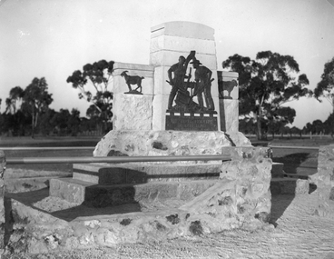
Photograph, Deep Lead Pioneers Memorial c 1936
The memorial was erected in c 1936 by the public to the pioneers of Deep Lead District. The memorial was to commemorate the early pioneers of Deep Lead. The bronze tablet depicts two miners at work, one operating the cradle while the other using the shovel. Behind the two men and partly framing the design, is the windlass set in a fork of a tree. On each side of the main tablature are two figures of goats, one a "Billy goat" the other a "nanny goat". The bronze sculpture is set on a pedestal of Grampian freestone, which is placed on the two steps of granite. The whole memorial is surrounded by an ornate stone fence. The bronze sculpture work was executed by Mr. S. J. Hammond of Melbourne while the stone work was carved and erected by Mr. G. Robson, of Stawell. The shire engineer Mr. C.W.C. Venables assisted with advice when necessary.Black and white photograph depicting the stone Deep Lead Pioneer memorial with native gums in the background. stawell