Showing 14151 items
matching hall street
-
 Halls Gap & Grampians Historical Society
Photograph - B/W
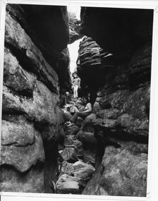
the three women appear to be in 'Silent Street', part of the Wonderland Range on the pathway to The Pinnacle lookout.3 young women sitting and standing amongst 2 rock cliffs with tumbled rocks that appear to form steps. a railing can be seen behind standing girl. Clothing is suggestive of the 1970s period.scenery, wonderland range -
 Heathcote McIvor Historical Society
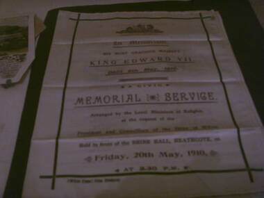
Memorial booklet, shire of mcivor, minsiters of religion, Silk Memorial Booklet Death of King Edward VII 6 May 1910, 06/05/1910-20/05/1910
Created for the memorial service that was held on friday 20th may 1910, held in front of the shire hall in Heathcote to honour king edward VII who died on the 6th may 1910 at 2.30 p.m. this was arranged by the local ministers of religion at the request of the president and councillers of the shire of McIvor.Believed to be the only one in exsistence, after intesive research have been unable to come up with any information, from the shire, local churches or senior members of the community,only mention was in the Bendigo Advertiser newspaper.research in to archives further afield have not produced another.Piece of cream silk printed on face and inside, screen printed in purple and black ink on front and inside the order of service. details of all ministers of religion and shire dignitries as well as hyms sung. "McIvor Times" Print, Heathcote on left hand side below main print. in black inkvictoria, silk memorial booklet, king edward vii, 1910, heathcote, ministers, of, local, churches, shire, president, mcivor, times -
 Ararat & District Historical Society (operating the Langi Morgala Museum)
Photograph
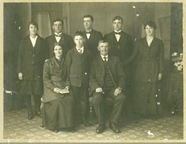
Black and white photo of 8 people - 3 females and 5 males. An older couple is seated with a young boy standing between them. All are dressed in formal suits.Written on back: Rita Snibson sec Women's Hospital. Front row: Nell Simpson had a son Jack had a business in Stawell then Melbourne. Nell became Mrs A.J. Sanderson who had a grocery business opposite Town Hall. -
 Ararat & District Historical Society (operating the Langi Morgala Museum)
Photograph
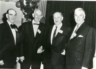
Black and white photo of four men in a hall. There is a tree and streamers.On back: Alan Blachford, Arthur Hargreaves -
 Ararat & District Historical Society (operating the Langi Morgala Museum)
Postcard
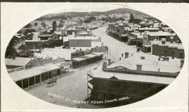
Black and white postcard of Barkly Street, Ararat. The photo is taken from the Town Hall. The Commercial Hotel and its balcony are pictured on the right while the zig zag of the main street looks like a dirt road.Addressed to Mr G. Mitchell, Collins St, Melbourne also a letter written on the back of the postcard -
 Ararat & District Historical Society (operating the Langi Morgala Museum)
Postcard
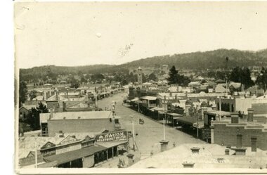
A black and white photographic postcard of a view of Barkly Street with Copes Hill in the background. Photo taken from Town Hall. Horse drawn vehicle in street scene. Shop front signs legible: A. Waugh Ready Money Draper, Albion Hotel, aganet for Brunnings, TRG Williams Photographer, E.I. Beynan, Fergusson's. -
 Ararat & District Historical Society (operating the Langi Morgala Museum)
Photograph
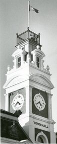
Black and white photo of the Ararat Town Hall clock and tower. -
 Ararat & District Historical Society (operating the Langi Morgala Museum)
Photograph
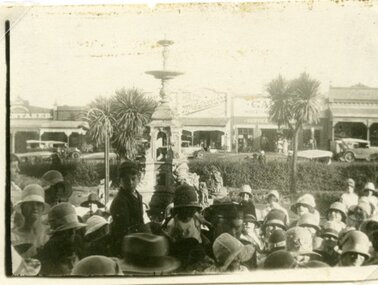
Black and white photo of a large group of people standing in front of a fountain. The fountain is located at the front of Ararat Town Hall. The group members are predominantly women wearing hats and there a few school boys wearing hats. -
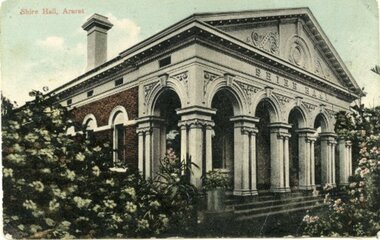 Ararat & District Historical Society (operating the Langi Morgala Museum)
Postcard
Colourised postcard depicting the Shire Hall Ararat. The building facade is brick with a white painted front.In gold print of the front of the postcard is written Shire Hall Ararat. -
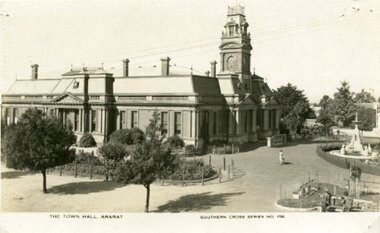 Ararat & District Historical Society (operating the Langi Morgala Museum)
Postcard
Part of the Rose Stereograph Co Armadale, VictoriaBlack and white postcard of Ararat Town Hall taken from a high position on the Vincent Street side of the building. A fountain can be seen on the right and there are two garden beds. A woman is walking on a path between the Town Hall and fountain.The Town Hall Ararat, Souther Cross Series 156 -
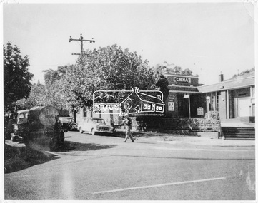 Eltham District Historical Society Inc
Negative - Photograph, Ian McDonald, Corner of Main Road and Arthur Street, Eltham, 4 Jan. 1968
... collection eltham arthur street cinema eltham hall main road shire ...The intersection of Arthur Street and Main Road Eltham, January 4, 1968. The Eltham Shire Council hall and offices on the right hand side. The Hall was also a cinema and operated as the Plaza Theatre from 1943 to about 1968. A truck with a water tank is on the left of the street, possibly cleaning the street. Note Cinema sign on hall. Copied from an original document produced by Ian McDonald (Eltham Shire Council) 1970. During the period 1969-1971 photos were being collected for a proposed publication on the history of the Shire of Eltham as part of its centenary celebrations in 1971 (managed by the Shire of Eltham Historical Society and Alan Marshall). The publication was Pioneers & Painters (1971), edited by Alan Marshall. The document titled "Shows area sold to Woolworths" consisted of a panorama of three B&W photo prints creating a panorama of the frontage along Main Road (SEPP_0744) and a single B&W photo print of the Shire of Eltham offices and Hall on the corner of Arthur Street and Main Road (SEPP_0737) along with typed and hand written notes by Ian McDonald. The panorama (SEPP_0744) was captioned in typewritten text "Old Shire Office and Hall, etc - Frontage of 285 feet along Main Road" and in pencil the date "4-1-68" The single image of the shire offices (SEPP_0737) was captioned in typewritten text "Main Road and Arthur Street Corner" In addition, the following handwritten notes in pencil: " I took these photos from the new fire station - the building in the middle is the old fire station - Moved to Research for the Scouts 1970" and signed "IMcD"This photo forms part of a collection of photographs gathered by the Shire of Eltham for their centenary project book,"Pioneers and Painters: 100 years of the Shire of Eltham" by Alan Marshall (1971). The collection of over 500 images is held in partnership between Eltham District Historical Society and Yarra Plenty Regional Library (Eltham Library) and is now formally known as 'The Shire of Eltham Pioneers Photograph Collection.' It is significant in being the first community sourced collection representing the places and people of the Shire's first one hundred years.Digital image 4 x 5 inch B&W Negsepp, shire of eltham pioneers photograph collection, eltham, arthur street, cinema, eltham hall, main road, shire hall, motion picture theartre, plaza theatre -
 Eltham District Historical Society Inc
Negative - Photograph, Ian McDonald (Shire of Eltham), Main Road, between Arthur Street and Dudley Street, Eltham, 4 Jan. 1968
L-R: Former Shire Hall and Shire Office, Photographer shop, Barber shop, Fire Station, Hardware shop and Commercial Bank of Australia. Copied from an original document produced by Ian McDonald (Eltham Shire Council) 1970. During the period 1969-1971 photos were being collected for a proposed publication on the history of the Shire of Eltham as part of its centenary celebrations in 1971 (managed by the Shire of Eltham Historical Society and Alan Marshall). The publication was Pioneers & Painters (1971), edited by Alan Marshall. The document titled "Shows area sold to Woolworths" consisted of a panorama of three B&W photo prints creating a panorama of the frontage along Main Road (SEPP_0744) and a single B&W photo print of the Shire of Eltham offices and Hall on the corner of Arthur Street and Main Road (SEPP_0737) along with typed and hand written notes by Ian McDonald. The panorama (SEPP_0744) was captioned in typewritten text "Old Shire Office and Hall, etc - Frontage of 285 feet along Main Road" and in pencil the date "4-1-68" The single image of the shire offices (SEPP_0737) was captioned in typewritten text "Main Road and Arthur Street Corner" In addition, the following handwritten notes in pencil: " I took these photos from the new fire station - the building in the middle is the old fire station - Moved to Research for the Scouts 1970" and signed "IMcD"This photo forms part of a collection of photographs gathered by the Shire of Eltham for their centenary project book,"Pioneers and Painters: 100 years of the Shire of Eltham" by Alan Marshall (1971). The collection of over 500 images is held in partnership between Eltham District Historical Society and Yarra Plenty Regional Library (Eltham Library) and is now formally known as the 'The Shire of Eltham Pioneers Photograph Collection.' It is significant in being the first community sourced collection representing the places and people of the Shire's first one hundred years.Digital image 4 x 5 inch B&W Negsepp, shire of eltham pioneers photograph collection, eltham, main road, arthur street, dudley street -
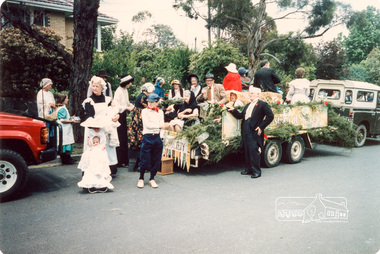 Eltham District Historical Society Inc
Photograph, Joh Ebeli, Start of the Parade in Cecil Street, Eltham Community Festival Parade, 8 November 1986, 08/11/1986
[from a contemporary report:] The Shire of Eltham Historical Society's entry in the 1986 Eltham Community Festival Parade included Ben Hall's Cobb & Co. coach along with several vintage motor vehicles and the Society's new Community Banner. Members dressed in in an appropriate costume to ride in one of the vehicles or walk along with them. The assembly point was in Cecil St. at 11.45 a.m. The Society's entry was awarded the major prize for the parade.Colour photographeltham festival, shire of eltham historical society, 1986, cecil street, eileen gibbons, peter bassett-smith, garnet burges -
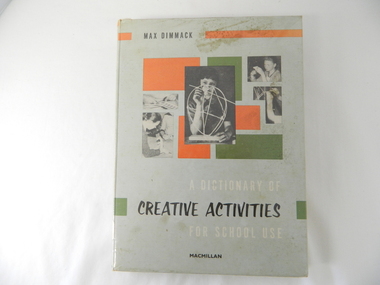 Kiewa Valley Historical Society
Book - Reference Teaching, Circa 1963
This teacher's aid publication targets the creative and imaginative areas of primary school children's development. It is in a time period at the beginning of television(home intrusion) broadcasts and concentrates on the mental and physical tasks that produce tangible(physical) outcomes. The book concentrates on furthering the students abstract regions of their imagination. This was in a period where physical not electronic flexibility were the target of development. The increase in visual communications both at home and outside the home through social media means has intruded into the fundamentals that is presented in this teacher's aid publication.This publication is significant to both the Alpine and the Kiewa Valley regions because it demonstrates the Victorian State's Educational objectives of this period in time (1960's - 70's). The primary school's educational objectives were to enhance the development of school children's abstract mental abilities. These abilities prompted the mental processes to "think outside of the square" and is one of the major factors behind the development of "new inventions". This ability has produced many "Australian" inventions that have had worldwide applications. This book has a hard cover with photographs of "school" children constructing various "simple" items.Inside cover has a sticker "HALL'S BOOK STORE" and underneath in smaller print "New, Used and Rare Books" underneath this "371 Bourke Street, Melbourne' underneath "262 Chapel Street, Prahran". On the fly leaf is stamped "STATE SCHOOL 4590 BOGONG Vic" and written below "1769" 680 DIM"book, school, mental and physical stimulation, school activities -
 Eltham District Historical Society Inc
Photograph, St Andrews Primary School, Eltham Heritage Tour, 24 May 1992, 24/05/1992
ELTHAM HERITAGE TOUR The Society excursion on 24th May 1992 was arranged by David Bick, leader of the team carrying out the Shire's heritage study. David selected a number of sites or buildings identified in the study, some of them lesser known components of the Shire's heritage. The tour commenced at the Eltham Shire Office at 10.00 am. Travel was by private car and mini-bus with stops at about twelve locations for commentary by David.It included a short walk in Hurstbridge and lunch at Kinglake. Highlights of the tour included: - 10 am Leave from Shire Offices - 3 Important Trees - A Physical Link to Eltham's First Settlers - Toorak Mansion Gates - A Surviving Farm House - An Intact Circa 1900 Main Street - First Settlers - Gold Miners, and Timber-getters - An Early Hotel - A Pioneering Homestead - Changing Eltham Shire - 20th Century - 4 pm Afternoon Tea and Finish Tour Extract from ELTHAM CULTURAL HERITAGE TOUR (Newsletter No. 85, July 1992, by Bettina Woodburn) "At St Andrews we noted the old and new schools, the Anglican Church, the Hall, the Bakery and the pub – still a popular watering and eating place. Climbing towards Panton Hill the soil was not rich and supported only scarce growth. Perfunctory prospecting and mining had taken place in this area, though not with the diligence applied at Research. Again we saw the ingredients of a settlement, this one organised by Government, the Hotel, the Store, the School. Down from Memorial Park the School grounds had original tree planting and the School Bell dedicated to Maud Rattray who died in 1922. There is a new Hall and opposite in the grounds of the Church and Sunday School a modest Memorial Cross of granite with inscriptions and in memory of four 'fallen comrades'. This small section of the main road retained the small village atmosphere; although the population had increased there had been little alteration."Record of the Society's history and activities and highlighting various aspects of the Heritage Study undertaken by David Bick used to create the future heritage overlay for the Shire of Eltham and later Nillumbik Shire.Roll of 35mm colour negative film, 4 stripsKodak Gold 100 5095shire of eltham historical society, activities, heritage tour, st andrews -
 Eltham District Historical Society Inc
Photograph, World War Two Memorial buildings on west side of Main Road, Eltham, February 1968, Feb 1968
Child Welfare Centre (opened 1952) and War Memorial Hall originally built for the Children's Library. Shows the Eltham Shire Office (built 1964) at left of photo.In February 1968 an unknown person took a series of photos from the Eltham Hotel at Pitt Street heading north along Main Road through the shopping centre to just north of Elsa Court covering the length of the section of Main Road which was duplicated shortly thereafter. Shows the condition and environment of the streesscape of Main Road, Eltham immediately prior to the duplication between Pitt Street and Elsa Court through the shopping centre. Also shows a number of shops and businesses that operated at that time.Black and white photographduplication, eltham, main road, shire of eltham war memorial, children's library, infant welfare centre -
 4th/19th Prince of Wales's Light Horse Regiment Unit History Room
Newspaper cutting, Drill Hall's Battle Over, 8 Dec 1994
The 4/19 PWLH Regiment was located at Bougainville Barracks, Carlton, until the land was sold off by Army for housing development.An article from the Herald Sun of Thursday 8 Dec 1994 about the closing of Bougainville Barracks in Park Street Carlton. It carries a photograph Col Frank Pearson with a Light Horse uniformed mannequin in front the 4th (late 20th Corangamite) Light Horse honour boardnewspaper, bougainville barracks -
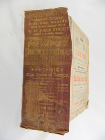 Kiewa Valley Historical Society
Book - Reference Melbourne Directory, Melbourne and Suburban Directory for 1889, Circa 1889
... Street opposite Town Hall", stamped on the top side across... Machines Swanston Street opposite Town Hall", stamped on the top ...This Directory of 1889 covers the location of Melbourne based trade and professional offices by street and in Alphabetical order. It covers all of Melbourne and its suburbs. It also covers government and official, ecclesiastic, legal, municipal and miscellaneous information. The directory details a cross section of a developing city with a splattering of advertisements opening up an in depth look of all aspects of living in the late 1800s. It is interesting to see that all the advertisements do not have any telecommunication numbers listed (personal shoppers or mail orders only). This was a period of high moral standing within the community and hotels advertised rooms " suites of rooms for families and single rooms for Ladies and Gentlemen" also "electric bells throughout the house. Telephone, night porter and hot and cold baths."This directory would be used by the majority of families and businesses working and living within the Kiewa Valley and the surrounding area. Melbourne was the only place where every aspect of living requirement was catered for. Although the delivery of services and goods were not at a high rate, certain items or transactions would require a visit to "the big smoke". Business information are listed both by suburb and alphabetically. There is also a section for British and Foreign Trade. This directory covered nearly everything to do with commerce, an example pay days for principle firms. Greater evolution of trade locations started to balloon out after the mid 1950's. Increased populations and greater levels of communication and safe fast transport facilities permitted greater devolution of commercial enterprises into rural communities, such as the Kiewa Valley.This directory has no front or back cover and is held together by its cloth spine. It contains over 1300 pages, however there may be some pages missing front and back of the directory which would have contained advertisements of some unknown shops. All the sides of this directory (except the spine) have advertisements and content information stamped on. The spine cover has been placed in the directory until further conservation work is carried out. It has gold coloured printing and in the central section, a gold coloured background with the words "Sands & McDougall's Melbourne Directory 1889." The spine has three adverts on the spine.On the spine in gold colour "South * British insurance Company Fire and Marine. Risks Lowest Current Rates No. 11 Queen Street, Arthur J Masters, Manager" and half way down " *Phoenix* Fire Office of London established over 100 years Annual Income exceeds (pound sign) 1,000,000" underneath "Losses Paid Over (pound sign) 16,000,000" underneath "Reserve Fund Exceeds (pound sign) 1,000,000" underneath "9 Market Buildings William Street, Melbourne " underneath " R. Manfield Taylor, Agent" and at the bottom section" Henry Scott Auctioneer and Estate Agent 49 Bridport St., Albert Park" stamped on the bottom side across the page endings "The Wonderful Wertheim Sewing Machines Swanston Street opposite Town Hall", stamped on the top side across the page endings " The Sweet Hapsburg Pianos & Organs Swanston Street Opposite Town Hall"state government listings, names and location of early melbourne population business names, 1889 members of the victorian executive council -
 Eltham District Historical Society Inc
Photograph, R.H. Luxmoore, Painting, 'The Hawthorns', R.H. Luxmoore, 1919, 2/2/19
Situated at the north corner of Main Road and John Street, Eltham; 'The Hawthorns' was the home of T.N. Jewell and his wife, 'Polly' Margaret Jewell (nee White). Painted by R.H. Luxmoore a boarder at the house. Polly Jewell was the aunt of current painting owner (Keith Johnson). Doug Orford's mother would visit her at the home every week.Located on the north corner of Main Road and John Street, Eltham; 'The Hawthorns' was the home of T.N. Jewell and his wife, 'Polly' Margaret White. Most likely viewed from location of where Methodist Church Hall was situated.eltham, the hawthorns, main road, john street, t.n jewell, polly margaret white, r.h luxmoore -
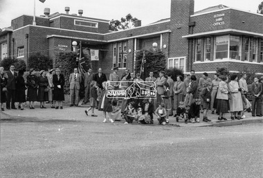 Eltham District Historical Society Inc
Photograph, Peter Bassett-Smith, Queen Elizabeth II Coronation celebrations and parade, Eltham, Jun 1953
Three black and white photographsalf davis, anz bank, army, arthur street, bert bredle, ceremonies, civic functions, coronation, councillors, cr e.p. harmer, cr f.v. squire, cr frederick e. griffith, cr stanley s. addison, dave lyon house, eltham hall, eltham lower park, eltham shire office, eltham village, eltham, frank davis mhr, guard of honour, main road, mr c.g. seear, mrs alf davis, mrs arthur bird, mrs e.p. harmer, mrs f.e. griffith, mrs frank davis, mrs ham, mrs s.s. addison, mrs squire, parade, queen elizabeth ii coronation, r.j. (dick) ham, shopping centre -
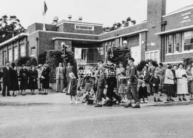 Eltham District Historical Society Inc
Photograph, Peter Bassett-Smith, Queen Elizabeth II Coronation celebrations and parade, Eltham, Jun 1953
Five colour photograph copies of original black and white images of various viewsarmy, arthur street, bands, ceremonies, civic functions, coronation, councillors, cr stanley s addison, eltham, eltham hall, eltham lower park, eltham shire office, eltham village, frank davis mhr, guard of honour, lyon bros garage, main road shops, main road, milk bar, parade, queen elizabeth ii coronation, r.c. staff, staffs general store -
Eltham District Historical Society Inc
Folder, Bradbury family, 1925
1. Councillor Joseph Bradbury 2. Memories of a Bradbury family member - probably Dorothy Ethel Bradbury A Fatal Accident (1933, September 22). Advertiser (Hurstbridge, Vic. : 1922 - 1939), p. 1. Retrieved July 30, 2024, from http://nla.gov.au/nla.news-article56742159 Dr Ronald Walter Bradbury b. 1904 was married to Una Isabelle Young. Siblings were Dorothy Ethel 1907, Geoffrey Gordon 1909 and Stanley George Peter Bradbury 1912 Parents were Joseph Walter Henry Bradbury (1874-1934) and Lydia Jane Barnett (1876-1967)Folder of information on Councillor Joseph Bradbury, Eltham 1925joseph bradbury, brougham steet, cartoon, dorothy ethel bradbury, dr r. bradbury, dr ronald, electric train, ellen sweeney, eltham, eltham obelisk, eltham shire councillors, eltham tennis club, franco and co, geoffrey gordon bradbury, hudson automobile, jock ryan, joseph walter henry bradbury, kangaroo ground hall, kookaburra, kydia jane bradbury (nee barnett), lavender park road, lydia jane bradbury, main raod, model t ford, mount pleasant road, mr sprott, new street, o'brien, percy leason, rev. tregear, ronald walter bradbury, school committee, schoolmaster dudfield, shire president, sir william irvine, sprott, stanley bradbury, stanley george bradbury, table talk, tilley, tilley's road, una isabelle, wingrove park -
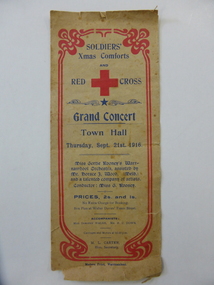 Warrnambool and District Historical Society Inc.
Document, Soldier's Xmas comforts, 1016
This is a program of a concert organized by the Soldiers’ Christmas Comforts Group and the Red Cross in Warrnambool to raise funds for the soldiers on active service in World War One. The concert was held in the Warrnambool Town Hall in September 1916 and featured a Melbourne artist, Horace Wood, who gave several violin solos and the local Warrnambool orchestra of Miss Gertrude Rooney. The Rooneys were early settlers in the Dennington area and had the property, ‘White Rock’ in Dennington and a produce store in Warrnambool. Miss Gertrude Rooney was an accomplished musician and was prominent in musical circles in Warrnambool during the first half of the 20th century. This program is of interest as an example of the fund raising activities in Warrnambool during World War One and of the type of entertainment offered at concerts at that time. There are many well-known names listed among the orchestra members at the back of the program. This is a sheet of buff-coloured paper folded in two to make four pages. The front page has an ornate red edging and there is dark blue printing on the front and back pages. The front page has a large Red Cross emblem The inside two pages have the printed program of concert items in black print. There are also advertisements for local Warrnambool businesses. The edges of the program are torn and ragged. world war one, warrnambool in world war one, gertrude rooney, musical entertainments in early 20th century, warrnambool -
 Warrnambool and District Historical Society Inc.
Documents, Technical Drawings Feed Pump
These drawings have been produced in 1919 by Ron Uebergang when he was a pupil at the Warrnambool Technical School. The Uebergang families were pioneers in the Warrnambool/Allansford area. Ronald Uebergang (1903-1971) was born in Warrnambool to Ernest Uebergang and Mary Watson. He went to Allansford State School and Warrnambool Technical School and married Myra Hall. He was mechanically-minded, a good photographer and fond of music and dancing. He and Myra had a dairy farm at the family property, Hopkins Hill near Allansford and later took up grazing beef cattle. Warrnambool Technical School was established in 1913, and was located first on a Timor Street site and later moved to Caramut Road. Today it is called Brauer College. These drawings are of considerable interest because they were produced by Ron Uebergang and the Uebergang families have been prominent in the history of the Warrnambool and Allansford areas since the 1850s. They are also of interest as examples of the type of work produced by students of Warrnambool Technical School in its early days. .1 A Blueprint for a Feed Pump for a Horizontal Engine - blue background, white drawings. The drawing is two-thirds of the full size object. .2 The same drawing on white see-through paper. The paper has a thick line drawn around the edges in black ink. .3 The same drawing on plain white card with drawings in black ink and a thick line drawn around the edges in black ink. .4 The original brown paper covering used to send the drawings to Warrnambool Technical School in 1921. There are also two pages of handwritten material attached to the drawings by a metal clip and giving a description of the design of the Feed Pump. ‘Warrnambool Technical School’ ‘Designed by R. Uebergang’ ‘Drawn by R. Uebergang’ ‘Date 7/10/19’ ronald uebergang, warrnambool technical school, history of allansford, history of warrnambool -
 Warrnambool and District Historical Society Inc.
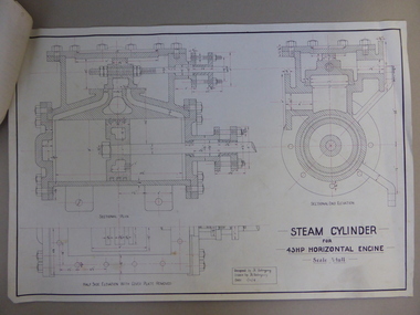
Document, Steam Cylinder Horizontal Engin, 1919
This drawing was produced by Ron Uebergang in 1919 at the Warrnambool Technical School. Members of the Uebergang families have been in the Warrnambool/Allansford area since the early 1850s. Ronald Uebergang (1903-1971) was born in Warrnambool, the son of Ernest Uebergang and Mary Watson. He lived at the family property, Hopkins Hill, and went to Allansford State School and Warrnambool Technical School. He was mechanically-minded, fond of music and dancing and a keen photographer. He married Myra Hall and they ran a dairy farm at Hopkins Hill and later went in for grazing beef cattle. Warrnambool Technical School was established in 1913, firstly at a Timor Street site and later at Caramut Road. Today it is called Brauer College. This drawing is of considerable interest as it was produced by Ron Uebergang. Members of the Uebergang families have been prominent in the Warrnambool/Allansford area since the early days of the district’s establishment. It is also important as a good example of the type of work produced by students from Warrnambool Technical School in its early years. This is a1919 drawing of a Steam Cylinder for a 45 HP Horizontal Engine. The drawing is half the full size of the cylinder. The drawing is on a white card with the sketches done in black and red ink. The card has a heavy black margin around the edges drawn in black ink. The drawing shows a Sectional Plan and a Half Side Elevation with the Cover Plate Removed. The card has the signature of Ron Uebergang. Attached by a metal clip to the card are four pages of measurements and plans of the steam cylinder. These are in black and red ink. Three of these pages have become partly detached. ‘Designed by R. Uebergang’ ‘Drawn by R. Uebergang’ ‘Date 1/12/19’ ronald uebergang, warrnambool technical school, history of allansford, history of warrnambool -
 Warrnambool and District Historical Society Inc.
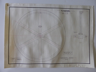
Drawing, Warrnambool Tech .1 Fly Wheel.2 Bevel Wheels R Uebergang, 1919
These drawings have been produced by Ron Uebergang at the Warrnambool Technical School in 1919. Uebergang family members were pioneer settlers in the Warrnambool area in the early 1850s. Ronald John Uebergang (1903-1971) was born in Warrnambool to Ernest Uebergang and Mary Watson. Ron Uebergang lived at the family property, Hopkins Hill at Allansford and went to Allansford State School and Warrnambool Technical School. He was mechanically minded, a good photographer and fond of music and dancing. He married Myra Hall and was a dairy farmer at Hopkins Hill and later grazed beef cattle. Warrnambool Technical School was established in 1913, firstly at a Timor Street site and later at Caramut Road (today it is known as Brauer College). These drawing are of considerable interest as works produced by Ron Uebergang. Uebergang family members have been prominent in the Warrnambool-Allansford area since the pioneering days of the district. The drawings also are good examples of the type of work produced by Warrnambool Technical School students in its early years.These are two designs and drawings by Ron Uebergang produced at the Warrnambool Technical School in 1919. They are drawn on white card using black and red ink. The scale of the Flywheel is three inches to one foot and the Bevel Wheels are one-third full size. The drawings are edged with heavy black lines. The two sheets have the signature of Ron Uebergang. There are also four pages of handwritten notes on the Flywheel and Bevel Wheels.‘Designed by R. Uebergang’ ‘Drawn by R.Uebergang’ ‘Date 4/1/19’ (on Flywheel sheet) ‘Date 27/5/19’ (on Bevel Wheels sheet) warrnambool technical school, ronald uebergang, history of allansford -
 Warrnambool and District Historical Society Inc.
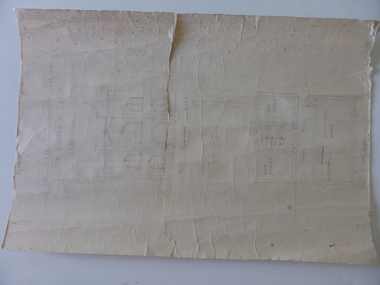
Document, Drawing of church of Christ Warrnambool, Mid 20th century
These are plans for proposed additions to the Church of Christ in Warrnambool. The date of the drawings and the maker of the plans are unknown. The additions do not appear to have been built. The Church of Christ in Warrnambool was founded in 1875 after a meeting at the Warrnambool Temperance Hall. The building in Spence Street Warrnambool was erected in 1884 at a cost of £1600 and officially opened in 1885. This church was sold and in 2000 the congregation moved to a new building at 186 Raglan Parade (called Gateway Church of Christ).These plans are of some interest as being part of the history of a Warrnambool church – the Church of Christ Warrnambool. These are two rough drawings on cream-coloured paper showing proposed additions to the Church of Christ in Warrnambool. The drawings are in pencil and include the front elevation plan and the first floor plan. The captions are in capital letters. Both pages have tattered edges and are torn across the middle and the pages are stained in places.‘Rough drawing suggested additions for Church of Christ Warrnambool’ ‘Suggested additions for Church of Christ Warrnambool’ church of christ warrnambool, gateway church of christ, history of warrnambool -
 Warrnambool and District Historical Society Inc.
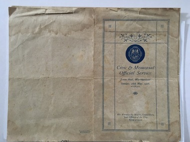
Document, Civic & Memorial Official Services 1918, 1918
These are two programmes of the Civic and Memorial Official Service held in the Warrnambool Town Hall on 26th May 1918. The service was held for two purposes. One was to celebrate the gazetting of Warrnambool as a city, two days earlier, on 24th May 1918. The other was to offer prayers and remember those on active service in World War One and those who had died in the war and to pray for the war to end. (World War One came to an end in the November of 1918). The service on 26th May in Warrnambool was conducted by the ministers of churches in Warrnambool and attended by the Mayor and Councillors and Council workers. A collection was taken up at the service for the British Red Cross Society. The Mayor at the time was William Swinton.This program is of considerable interest as it brings to our attention two events of importance in our history – Warrnambool becoming a city in 1918 and the city’s involvement in World War One and the long-term effects of this war on all settlements in Australia. It also highlights the importance at the time of the Christian religions in Australia.These are two copies of the programme of the 1918 Warrnambool Civic and Memorial Service. The programme is one sheet of buff-coloured paper folded in two to make four pages. There is blue printed material on three of the pages. The front page has the crest of the City of Warrnambool with blue edging and some ornamental scrolls. One programme is tattered at the edges. The two programmes have been glued together at the bottom left corner and have been partly mounted on a piece of white card. warrnambool city council, program civic memorial service 1918 -
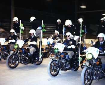 Victoria Police Museum
Photograph (police motorcycle)
Honda CB900F motorcycles being ridden in exhibition formation. Riders are L to R Tony Borg, Paul Martin, Dave Rogers, Barry Olsen and John Hall. Circa 1980police vehicles; wireless patrol; motor transport branch; motor transport section; motor cycle patrol; police motorcycles; honda motorcycle; borg, anthony; martin, paul; rogers, martin; olsen, barry; hall, john -
 Victoria Police Museum
Police Stations (Apollo Bay)
Apollo Bay is a coastal town in southwestern Victoria. It is situated on the eastern side of Cape Otway, along the edge of the Barham River and on the Great Ocean Road, in the Colac Otway Shire. The original township was surveyed in 1853 and named Middleton. In 1881 the town was renamed Krambruk which was changed to Apollo Bay in 1898. The Krambruk Police Station was opened on 7 March 1888 in the Southern District on land opposite the site of the current Mechanics' Institute and changed its name to the Apollo Bay Police Station on 1 September 1990. It came under the Barwon District in 1948 and "Lima" Western District from 4 March 1990. In 1930 the police station was located to 29 Nelson Street. It was a seven-roomed weather-board dwelling on three-quarters of an acre of land. It consisted of six rooms of pine, lined and painted; one pantry; one bathroom and wash-house; one hall; one office and one W.C.. There was stabling for one horse and one cell for prisoners. It was staffed by one Mounted Constable. In the early 1970s land was acquired at 31 Nelson Street and a new police station was constructed. This was a three-roomed brick building with a cell block at the rear. By the time it closed in 2005 it had been extended twice. On 17 November 2006 the current Apollo Bay Police Station opened in its current location at 35a Nelson Street, on the corner of Cartwight Street). Outside the peak summer season, the station is open 16 hours per day and staffed by one sergeant and five other members. 3 black & white photos and 2 coloured photospolice stations; apollo bay police station