Showing 8062 items
matching blocked
-
 Greensborough Historical Society
Photograph - Digital image, Marilyn Smith et al, Janefield Precinct: Outside building next to admin block, 27/11/2014
Janefield Precinct: Outside building next to admin block. The remains of this site are between Greensborough and Janefield. A RAAF Hygiene Training Camp was located on the Plenty River, just south of the Janefield community. It was in use from 1944 to 1946. The Camp was constructed from salvaged materials. Instruction included building and maintenance of grease traps, latrines, elementary plumbing and carpentry.Early remains of a WW2 training camp Digital colour photograph. -
 Connecting Home
Book, National Archives of Australia and Public Record Office Victoria, Footprints: The Journey of Lucy and Percy Pepper ...an Aboriginal family's struggle for survival, 2008
This book tells the story of the Pepper family, an Aboriginal family who experienced child removal and displacement. Percy Pepper also served in the First World War and was one of few Aboriginal service men who recived a soldier settler block. Also contains pictures, photos and records of histroical importance, including records from the Aborigines Protecion Board.Historical significance: This book is significant as it describes in detail an Indigenous family story. It also contains copies of original government reports and talks about the Indigenous experience of child removal in Victoria. Socially, it is relevant because of it's links to Aborigianal places of significance such as Lake Tyers.Softcover book, 132pages, brown cover with Indigenous design and black and white family photograph. al'. Conent is about the Pepper family, and contains family records.book, percy, pepper, lucy, family, stolen, generations, footprints, national, archives, public, records, office, victoria -
 Orbost & District Historical Society
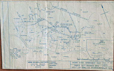
plan, December 1968
Brodribb floodplain regularly inundated in the late 1800s and early 1900s. Works included: clearing the river channel and blocking ‘gulches’. The meander was cut-off in 1931, as part of the Orbost East Drainage Scheme and further developed after 1934 floods and again in the early 1950s when levee banks and a regulator were constructed. (ref. East Gippsland Catchment Management)This is a useful reference tool.A hand-drawn plan of the layout of the levee banks of the Old Brodribb River.brodribb-river map plan-levee-banks -
 Federation University Historical Collection
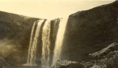
Photograph, Wannan Falls near Hamilton
Wannon Falls were created by lava flows that surged upstream to the Wannon River. The cascade is a 30 metre vertical drop into a deep plunge pool. Downstream rapids wind their way around large blocks of basalt. The Wannon Falls have been painted by notable artists such as Nicholas Chevalier, Eugene von Guerard, Thomas Clark and Louis Buvelot.Black and white photograph of a waterfall cascade known as Wannon Falls.Verso in black ink handwriting 'Wannon Falls near Hamilton'chatham family archive, chatham, wannon falls, hamilton, waterfall -
 Churchill Island Heritage Farm
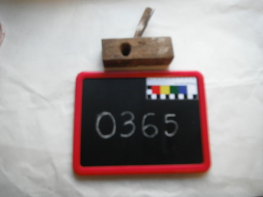
Tool - Coping plane
This was a specialized plane used for making the complex shapes found in wooden custom mouldings such as picture frames, architraves and furniture. The planes were blocks of wear-resistant hardwood which were worked in the shape of the intended mouldings. The blade was formed to the shape of the intended profile and secured in the body of the plane with a wooden wedge. The modern-day router would perform these tasks today.Hand made from scrap wood. Hardwood - file has been converted to a blade for making inlays.plane, hand tools, carpenter's tools, coping plane -
 Robin Boyd Foundation
Document - Script, Robin Boyd, The Flying Dogtor. Episode 9 The Helping Hand, 1963
Elvis resumed pouring the rainmaking powder onto the clouds and the Dogtor could not loosen the logs that were blocking the creek bed. Because the Dogtor had been so nice to Elvis, in the end, Elvis helped the Dogtor dislodge the logs and the flood subsided. But Crafty Carson Carpetbag and Old Man Redback lay waiting, scheming, planning their next nasty surprise.The Flying Dogtor" series was broadcast on Australian Television Network (later becoming the Seven Network) between February and April 1964 (see item D254 for schedule).Typewritten, carbon copy, foolscap, 2 pagesthe flying dogtor, robin boyd, crawford productions, manuscript -
 Mt Dandenong & District Historical Society Inc.
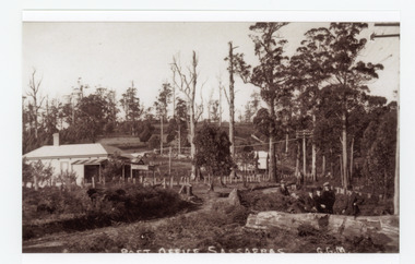
Photograph, Post Office Sassafras, c1930s
View of Hinkley Guest House on the left where the Post Office occupied a room in the front corner. The post operated from 1912 until 1937 when the building burned down. The Post Office then moved up to one of the Cadby Cottages near Rostrevor. The empty block of land next to Hinkley was where Sassafras School was built a few years later.Black and white copy of GGM photograph showing a group of five well dressed men in the foregroundbehind a large log with the Post Office and Telegraph office on the left.On front - POST OFFICE SASSAFRAS G.G.M.sassafras, post office, post office, hinkley, cadby cottages, sassafras school, rostrevor -
 Mt Dandenong & District Historical Society Inc.
Photograph
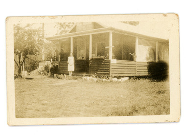
Jim Keogh owned Lot 7 of the Village Settlement. When the new CRB road went through c1920 his block was cut through leaving a small triangle of land on the high side of the CRB road. He built a shop on this piece of land. The store burned down 31/12/1939. The woman on the step in this photo is Win Woodcock.Sepia image of a woman standing in front of a wooden store. Handwritten inscription on reverse by John Lundy-ClarkeJim Keogh's shop on the north west corner of Falls and Main Roads. Opposite diagonally from St Michael's Church of England. photo Nov 1926.jim keogh, keogh, store, shop, crb road, win woodcock -
 Port of Echuca
Black and white photograph, 1975
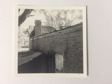
The brick old Murray River Sawmill office was demolished around 1975. This photograph is of the side of the building taken from behind. It shows a corrugated lean-to and a window or door way that appears to be blocked off. There is a large crack in the brick work wall beside this doorway. Part of the back of the front brick facade is visible behind a brick chimney. This relates to photographs P000106, P000107.Sawmills in the Echuca area were historically and socially significant being a large employer in the area. The Murray River sawmill was one of the biggest and longest operating sawmills in the area.Black and white photograph of the old Murray River Sawmills building, taken from the road. Shows view from a rear side, with a window and corrugated iron lean-to. Part of back of facade can be seen as well as the chimney.On back of the photograph in pencil "Old Murray R Sawmills bldg, in from road." In black pen "Old office demolished c.1975" stamped in blue ink "0932"murray river sawmills, echuca, sawmills, echuca, vicotria, pullicino, j -
 Wycheproof & District Historical Society Inc.
Bunguluke Map, Bunguluke District In 1923, 27.2.1923
By 1881 Bunguluke was a small settlement as recorded, December 5, in the Charlton "Mercury". It reports that in that year Draper's Store, Hotel and Post Office and residence at Bunguluke North was totally destroyed by fire. For years now there has been little sign of community life with houses few and far between and acreages have gone into larger holdings. The map references land blocks and owners for that era.This important map shows the local land ownership and local features that existed in 1923. This is a photocopied black and white map of Bunguluke in the County of Kara Kara, Number L5149. Marked - Photo Lithographed by W.J. Butson 27.2.1923. The details include numbers of allotments, property owners, roads, rivers. The boundaries marked are the Parish of Jeruk, Parish of Wycheproof, Parish of Cooroopajerrup. Wycheproof township location is shown with the Scale of Chains. Bunguluke maps for other years are also in the collection.map, bunguluke, jeruk, wycheproof, cooroopajerrup -
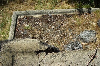
 Greensborough Historical Society
Photograph - Digital image, Marilyn Smith et al, Janefield Precinct: World War 2 era concrete admin block, 27/11/2014
Janefield Precinct: World War 2 era concrete admin block. The remains of this site are between Greensborough and Janefield. A RAAF Hygiene Training Camp was located on the Plenty River, just south of the Janefield community. It was in use from 1944 to 1946. The Camp was constructed from salvaged materials. Instruction included building and maintenance of grease traps, latrines, elementary plumbing and carpentry.Early remains of a WW2 training camp Digital colour photograph.janefield -
 Greensborough Historical Society
Photograph - Digital image, Marilyn Smith et al, Janefield Precinct: World War 2 era admin toilet block, 27/11/2014
Janefield Precinct: World War 2 era admin toilet block. The remains of this site are between Greensborough and Janefield. A RAAF Hygiene Training Camp was located on the Plenty River, just south of the Janefield community. It was in use from 1944 to 1946. The Camp was constructed from salvaged materials. Instruction included building and maintenance of grease traps, latrines, elementary plumbing and carpentry.Early remains of a WW2 training camp Digital colour photograph.janefield -
 Churchill Island Heritage Farm
Tool - Moulding plane
This was a specialized plane used for making the complex shapes found in wooden custom mouldings such as picture frames, architraves and furniture. The moulding planes were blocks of wear-resistant hardwood which were worked in the shape of the intended mouldings. The blade was formed to the shape of the intended moulding profile and secured in the body of the plane with a wooden wedge. The modern-day router would perform these tasks today. Oak body, rosewood base, steel blade and brass base. Some paint spots. (Doesn't need handle).plane, moulding plane, hand tools, carpenter's tools -
 Whitehorse Historical Society Inc.
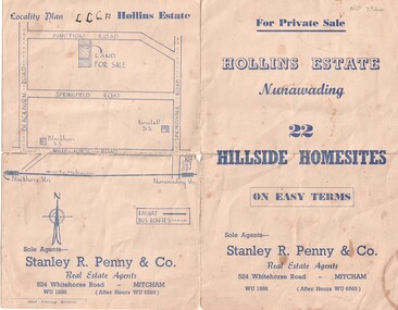
Document, Hollins Estate, 1955
Private sale of 22 hillside home-sites on Junction Road, Blackburn, called Hollins Estate by Stanley R. Penny & Co., 524 Whitehorse Road, Mitcham.hollins estate, stanley r. penny & co., real estate agents, blackburn, junction road, suto, joyce -
 Merbein District Historical Society
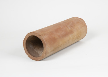
Tool - Aggie pipe
with early in precise furrow irrigation ground water mounds developed on blocks which were detrimental to vine growth Aggie pipes were laid on grade on the clay layer of soil 4 to 5 foot deep or every 4th row of vines (forty four feet apart) to drain the perched water table and the accumulated salts from the vines root zone with early in precise furrow irrigation ground water mounds developed on blocks which were detrimental to vine growth Aggie pipes were laid on grade on the clay layer of soil 4 to 5 foot deep or every 4th row of vines (forty four feet apart) to drain the perched water table and the accumulated salts from the vines root zone Long clay cylinder horticulture, merbein, irrigation, pipes, furrow irrigation -
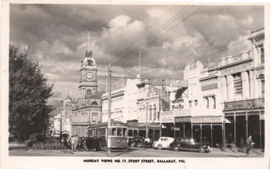 Ballarat Tramway Museum
Postcard, Murray Views, "Murray Views No. 17 Sturt Street Ballarat Vic", 1948
Photo shows the view looking east from Doveton St of the south side of Sturt St. Has bogie tram No. 15 in the view, westbound to the Gardens via Sturt St west picking up a large group of passengers. In the view are the Town Hall, Myer, Stansfield & Smith, the Block Arcade, and a Hatter and Tailor shop. Another tramcar can be seen in the view as well.Yields information about Sturt St, tram services and patronage.Postcard black and white, divided back, with a handwritten note on rear.In ink on the rear "Looking west from Doveton Street 1948" tramways, trams, sturt st, doveton st, tram 15 -
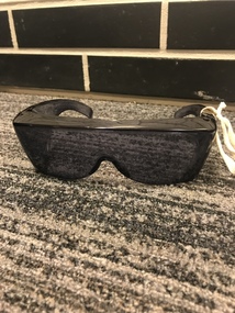 Vision Australia
Functional object - Object, Fitover glasses with case, 199
The Fitover sunglasses are designed to be worn directly over your prescription glasses. This wrap-around style blocks light from above and both sides which can benefit, alleviate and prevent many symptoms of common eye diseases by providing 100% UVA/UBA protection from harmful UV rays. This pair and case is labeled with the RSB logo and 'Royal Society for the Blind'.1 pair of black fitover glasses with soft caseOn both glasses and case: RSB The Royal Society for the Blind (with logo)assistive devices, royal society for the blind -
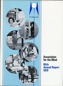 Vision Australia
Administrative record - Text, 84th Annual report 1979 Association for the Blind of Victoria, 1979
Articles in annual report include: the opening of the new Craft, Recreation and Activities Centre at Mirridong and Kelaston Community Day Hospital, 60 bed nursing home at Mt Eliza almost nearing completion, waiting for approval for 30 bed nursing ward at Shepparton, block of land secured at Warragul for future day centre, loss of Stan Middleton and retirement of Alex Cook.1 printed volume with illustrationsannual reports, association for the blind -
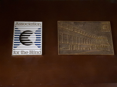 Vision Australia
Photograph - Image, Association for the Blind on wooden board
Association for the Blind symbol of a square (filled with horizontal lines crossed by two diagonal lines), in black and blue and a circle in the middle with lines inside it on a white background sits to the left of the block. An outline image of the Vision Resource Centre at Kooyong in bronze is to the right of the plaque. It also has the AFB symbol and the words Association for the Blind above and below the symbol. It is unknown where this plaque was located.1 digital image of two plaques on a boardAssociation for the Blindassociation for the blind, nameplates -
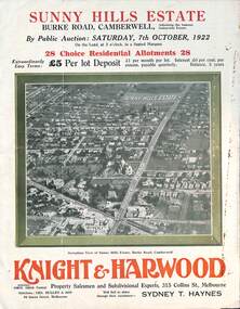 Melbourne Tram Museum
Ephemera - Real estate sale, Knight Harwood, "Sunny Hills Estate" - Burke Road Camberwell, Oct. 1922
Pamphlet advertising the sale of land at the "Sunny Hills Estate" Burke Road Camberwell 7-10-1922. Gives terms of sale, photos showing a nearby shopping centre, recently constructed houses, and plan of the subdivision. Land prices have been written in for each block on the pamphlet. Has a photo featuring Camberwell Junction with a tram, and Burke Road view with trams. Demonstrates the style of land sale pamphlet including the availability of tram services to prospective purchasers.Pamphlet - folded - printed in three colours of cream coloured paper with photographs and plans.has ink notes re sale price and notes.sale of land, trams, real estate, burke road, camberwell, sunny hills estate -
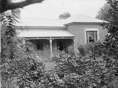 Stawell Historical Society Inc
Photograph, “Eyrecourt” House now 5 Scallan Streetin c1900's, Approx 1902
Postcard of “Eyrecourt” 1900s now 5 Scallan Street. Bill Kinsella's parents William Jennings Kinsella and wife Sarah nee Peardon lived there when first married in 1902 until they moved to farm in Ashens 1911. In 1919 the Chinese Herbalist Dr. Charles Lum lived at "Eyrecourt". It is not know who built the house or when it was demolished but the block was vacant in 1960's.B/W. Photograph of a Brick housewith an iron roof with a veranda, lots of Plants in foreground. On Rear Post card "Eyrecourt" Scallan Street No 5 Scallan Street A Picard Stawellstawell -
The Ed Muirhead Physics Museum
Microtome/W... (H.A. Waters)
Microtome for cutting resin embedded tissues for electron microscopy. In 1957 a modified hodge microtome redesigned and built by H.A. Waters of the Melbourne University Department of Physics was acquired. The Waters microtome is of thermal expansion type - the rod “A” is heated and by expansion pushes the resin block forward by a fraction. It is mounted on a long cast iron base. The movement of the block is eccentric drawing the specimen away from the knife after cutting, The glass knife ‘B’ is adjustable by means of a modified microscope column screws ‘C’. The microtrome is driven by a continuous action electric motor mounted on the common base. Hand cutting can also be done. The cutting was controlled by viewing through a Leitz Binocular microscope mounted on the same base. The original microscope was subjected to nine modifications by Dr S Weiner from whose PhD Thesis (1962) ‘Electron Microscopical Studies of the Liver’ this information was obtained. (text provided by Professor H Attwood) Microtome made of metal and enamelled in light blue. Components are identified by the use of stick on labels. The microtome is mounted on a long cast iron rectangular base and has an electrical cord for connection to a power point.Plaque on back: “Pathology Department, University of Melbourne Serial No. 0091. Date: 7/7/1968” -
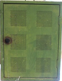 Wodonga & District Historical Society Inc
Domestic object - Meat Safe known as a "Coolgardie safe", Early 1900s
The Coolgardie safe was invented in the late 1890s on the Western Australian goldfields. Its invention was credited to a local contractor named Arthur Patrick McCormick. It was a practical system to preserve food prior to modern refrigeration. The wire grid kept the food safe from vermin and allowed breeze to blow through. It was often covered with wet hessian so that as the breeze circulated the water evaporated, creating the same concept as coolant in modern refrigerators and ice boxes. In most respects it was a variation of the bushman’s hessian bag hanging in a tree. In larger towns and cities during this time period large "ice works" could deliver block ice to areas that required a form of refrigeration. These ice blocks where held in early refrigerators to keep perishables cool. In isolated or rural households, the Coolgardie or meat safe was the next best, practical solution for food preservation. This safe was used in the home of the Conway family in Wodonga.This item is very significant to the Wodonga region as it represents the initiative and problem solving skills of the early settlers. It also reflects the primitive conditions in which they lived before the arrival of more modern services such as electricity.Meat safe or Coolgardie safe manufactured in Australia. This safe is made from metal and has been painted in green paint. 2 sides of the safe have a pattern of 6 squares of holes to allow for ventilation and air flow. The holes would also guard against insects and other vermin. There is one shelf inside, dividing it into 2 sections. The safe has a hook attached so that it can be suspended, often from a tree or on a verandah to increase air flow. The safe would often be covered by wet hessian to promote further cooling and preservation of foods such as milk, butter and meat.coolgardie safe, food preservation, pioneers innovation -
 Kiewa Valley Historical Society
Report - Alpine Study Area Volume 2 Maps, Land Conservation Council, 1970s
The Victorian Environmental Assessment Council and the former Environment Conservation Council (ECC) and Land Conservation Council (LCC) have completed 36 land use investigations over more than 35 years, including 27 regional reviews. They provide a framework for use of Public Land in Victoria. The Land Conservation Council was established by the Land Conservation Act 1970.These maps provide an assessment of the Alpine area at the time the maps were created. Some of the topics eg. Rainfall and water resources may change over the years thus providing a comparative analysis. Others may provide information for future development such as mineral exploration, building of a dam / tunnel etc.Blue box shaped folder containing 9 of 10 Maps of the Alpine Study Area produced by the Land Conservation Council. Maps include 1. Public land and descriptive blocks. 2. Physiography. 3. Topography. 4. Geology (missing). 5. Rainfall and water resources. 6. Vegetation 7. Land systems. 8. Recreation. 9. Primary production. 10. Minerals Ex library item. Stamped in red "Discarded From Stock / Swan Hill Regional Libraryalpine area, maps of alpine area, land conservation council -
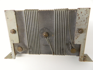 Kiewa Valley Historical Society
Resistor 2000 Amperes, circa mid to late 1900's
This resistor was part of the Hydro generator control metering system which displays what electricity is produced at the underground generators. The control centre can be hundreds of meters above the generators and this resistor reduces the large current to a small voltage entering a calibrated control monitor. This resistor is highly significant to the Kiewa Valley because it represents a major construction and ongoing operational industry dealing with the supply of hydro electricity to Victoria. Although it is relatively small in size it is part of the controlling mechanism for the supply of a non polluting energy source for home and industrial use.This mainly metal and wire resistor has been built of copper and brass and designed to carry a current of 2000 Amperes. Wires are wound around a non conductive cement block which has grooves on the top and bottom ledges to hold the wires snuggle into place. At the rear there are three connection rods which have long 5mm thick screws (to fasten cable ends)On one side it is scribed "0.2 OHMS" and underneath this "10 AMPS"kiewa hydro electricity scheme, victorian state electricity commission, transformers -
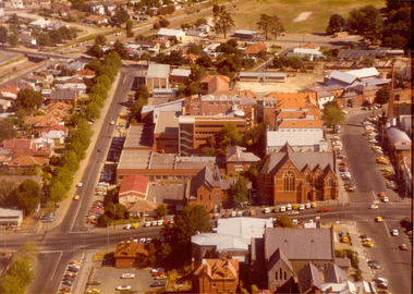 Federation University Historical Collection
Photograph - Photograph - Colour, Aerial View of the Ballarat School of Mines
This aerial photograph was taken before the E.J. Tippett library on the Ballarat School of Mines campus was built. Aerial photograph of the Ballarat School of Mines block bounded by Albert Street Dana Street, Lydiard Street South and Grant Street. Buildings shown include the Uniting Church, Flecknoe Building, Corbould Hall, Old Chemistry Building, Former Wesleyan Church, Administration Building, former Ballarat Gaol Gates (gaol demolished), Amenities Building, Ballarat Brewery, St Johns'.ballarat uniting church, flecknoe, flecknoe building, corbould hall, old chemistry building, former ballarat wesleyan church, administration building, former ballarat gaol gates (gaol demolished), aerial, amenities building, ballarat brewery, st johns' cathedral, albert street, lydiard street south, grant street, dana street, white flat -
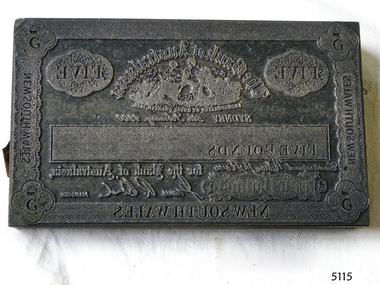 Flagstaff Hill Maritime Museum and Village
Currency - Engravers Plate, Five-pound, 15-02-1900
This banknote plate was created for the Sydney branch of the Bank of Australasia in February 1900, before the Federation of Australia. After printing the banknotes from this plate the printer would have overprinted the banknotes with a unique serial number and the denomination of the banknote in capital letters using a contrasting ink. The Bank of Australasia was incorporated by Royal Charter of England in March 1834. It first came to Australia on 14th December 1835, opening in Sydney. In that year, the Acting Superintendent of the Bank of Australasia in Sydney was David Charters McArthur. He went on to become the Superintendent from 1867-to 1876. The Melbourne branch of the Bank of Australasia opened on 28th August 1838. In 1951 the Bank of Australasia amalgamated with the Union Bank to form the Australia and New Zealand Bank, now known as the ANZ. Then in 1970 the ANZ merged with both the ES&A and the London Bank of Australia to form the ANZ Banking Group Limited. The ANZ Banking Group Ltd kindly donated a variety of historic items from the Bank of Australasia. BANK of AUSTRALASIA, WARRNAMBOOL – The Bank of Australasia was the first bank in Warrnambool. It was established in 1854 and operated from leased buildings on Merri Street and then Timor Street. The bank opened its own building on May 21, 1860, on the northeast corner of Timor and Kepler Streets. Mr A Butt was the Manager of the Warrnambool Branch in 1895. This significant item of early Australian social history gives a snapshot into the founding and early development of the banking system in Australia. The plate has historical significance as it belonged to the Bank of Australasia which was established in 1834 by Royal Charter and opened in Sydney, Australia, in Sydney in 1835. The plate is significant for its association with the Bank of Australasia, which had a branch in Warrnambool. Warrnambool's branch was the first bank in Warrnambool, established in 1854. The bank continued to operate until its merger in 1951 when it became the ANZ Bank, which is still in operation today. The Bank was an integral part of the establishment and growth of commerce in Colonial Warrnambool and throughout Australia.Printer's plate for a five-pound note, attached to a block comprising several layers of different varieties of wood. Rectangular metal plate embossed with the banknote's design and produced by the Sydney, New South Wales, branch of the Bank of Australasia. The border includes numbers and text. The image of the bank's logo is included, along with the banknote's denomination in letters and numerals, a signature and a date of 15th February 1900.On the border: in each corner "5", on sides and base "NEW SOUTH WALES" Within the border "FIVE" "The Bank of Australasia / INCORPORATED BY ROYAL CHARTER IN 1835" "FIVE POUNDS' "SYDNEY 5th of February 1900" "for the Bank of Australasia" (Signature) , "MANAGER" Image: (Bank's logo) [Two female figures seated together in a paddock, produce beside them, sheep and buildings in the background]flagstaff hill, warrnambool, shipwrecked coast, flagstaff hill maritime museum, maritime museum, shipwreck coast, flagstaff hill maritime village, great ocean road, bank of australasia, union bank, australia & new zealand bank, anz bank, sydney, new south wales, currency, banknote, legal tender, commerce, banking, five-pound note, banknote plate, printing plate -
Bendigo Historical Society Inc.
Map - CAMPBELL COLLECTION: BENDIGO AND DISTRICT MAPS
Map. Block plan key, Bendigo and surrounding districts including : Sandhurst, Nerring, Huntly, Neilborough, Salisbury, Yarrayne, Bridgewater, Yarraberb, Derby, Leichardt, Tarnagulla, Marong, Woodstock, Shelbourne, Lanecoorie, Lockwood, Ravenswood, Mandurang, Sedgwick, Kimbolton, Eppalock, Strathfieldsaye, Axedale, Wellsford, Ellesmere, Bagshot, Goornong, Nolan, Whirrakee, Egerton, Minto. (number 347 in map cupboard 1)map, bendigo, allotments -
 Bendigo Historical Society Inc.
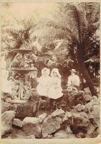
Photograph - UNKNOWN FAMILY COLLECTION: PHOTOGRAPH, 1798
Photograph - black and white. Two lots of writing, first one 'Bright day, Fernery, Gardens, Eaglehawk, Easter 97' (1897). 2nd lot of writing - 'To right of main gate behind present toilet block - remains of fountain shifted to new position - E'hawk Fernery'. In the photo are two young girls, a woman sitting behind them, a man and a woman standing in the background.place, eaglehawk, eaglehawk fernery, photograph. eaglehawk fernery. 2 young girls. -
Port Melbourne Historical & Preservation Society
Photograph - Aerial view of J Kitchen & Sons site, Port Melbourne, 21 Mar 1939
Large black and white aerial photo in narrow gold-coloured metal frame of J Kitchen & Sons Pty Ltd factory with Woodruff St in foreground (Electric candles, pure Velvet Soap,and full company name on buildings) "Aerial view looking East. This view shows the two main blocks . 21/3/39" - printed below photo (copy of original)industry - manufacturing, built environment - industrial, j kitchen & sons pty ltd, pental products pty ltd, symex holdings ltd