Showing 2602 items matching " parts of buildings or structures"
-
 Falls Creek Historical Society
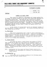
Letter - Parking At Falls Creek Circular
Bob Hymans Collection Bob (Herman) Hymans (a former member of the Royal Netherlands Navy) was born in Bloemendaal, Holland on 30th September 1922. During World War II he fought against the Japanese in the Dutch East Indies (now Indonesia) and was imprisoned in Changi and on the Burma Railway. September 1922. After gaining qualifications as a Ski Instructor, Bob arrived in Falls Creek in July 1950. Working as an Instructor and Supervisor at Bogong Lodge, Bob decided his future was in accommodation. He was successful in negotiating an indenture for land from the State Electricity Commission (SEC). It took Bob two years to build his Grand Coeur Chalet but, tragically, it was burned down in August 1961. Bob also built the first Chairlift in Australia. This was a single chairlift and the structure was built from wooden electricity poles. He was constantly full of new ideas and proposals for the village. Bob Hymans died on 7th July 2007. This Collection of documents and letters tells the story of Bob's endeavours to develop Falls Creek into the ski village it is today.This letter is significant because it documents a changed approach to the management of visitors and transport at Falls Creek.A letter to Licensees at Falls Creek explaining the reason for the introduction of parking fees in some sections of the Falls Creek Tourist Area in the winter of 1960. The system included limited access to free passes amd season tickets. Season tickets could be obtained at a cost of £1/10/-. Parking fees for cars were set at 2/- per day or part thereof and 4/- per weekend or week. The fee for buses was 5/- per day or part thereof.falls creek administration, parking fees falls creek 1960 -
 Stawell Historical Society Inc
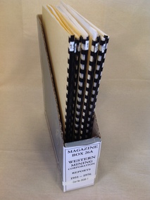
Book, Western Mining Corporation, Western Mining Corporation Reports 1951-1976, 1951-1976
10 Yellow Card and Black Plastic Spine With W.M.C Logo13: Western Mining Corporation Limited G Report No. 34 & 35 14 Western Mining Corporation Limited. The Relationship of Structure and Ore Deposition at Stawell Goldfield, Victoria. 15: Western Mining Corporation Limited. Enviroment Suitable Mining Development Proposal Stawell, Victoria 16: Western Mining Corporation Limited.. K report No 1832 Victorian Drilling Problems 1950 -1965 17: Western Mining Corporation Limited. Exploration for Structural Repetitions at Stawell Victoria A Case History By R.J.S. Clappison 1974 18: Western Mining Corporation Limited. K Report No. 1830 Stawell Prospecting 1958-1965 19: Western Mining Corporation Limited.. Stawell Feasibility Study By K.E. Higgs, J.H. Lalor, J.A. Heycroft & Stawell Start up Gold Price R.A. Nichols. 20: Western Mining Corporation Limited. Proposed Percussion Drilling at Stawell 1975 By D.R. Quick. K Report No 2211 1974-1976stawell gold mining -
 Glen Eira Historical Society
Album - Album page, Labassa Conservatory, 21 Manor Grove, Circa 1972
This photograph is part of the Caulfield Historical Album 1972. This album was created in approximately 1972 as part of a project by the Caulfield Historical Society to assist in identifying buildings worthy of preservation. The album is related to a Survey the Caulfield Historical Society developed in collaboration with the National Trust of Australia (Victoria) and Caulfield City Council to identify historic buildings within the City of Caulfield that warranted the protection of a National Trust Classification. Principal photographer thought to be Trevor Hart, member of Caulfield Historical Society. Most photographs were taken between 1966-1972 with a small number of photographs being older and from unknown sources. All photographs are black and white except where stated, with 386 photographs over 198 pages. WHAT IS SIGNIFICANT? [From Victorian Heritage Database citation for Former Labassa Conservatory - H2005 Victorian Heritage Register http://vhd.heritage.vic.gov.au/places/result_detail/12504 (25/01/2021)] The former Labassa Conservatory is believed to have been built as part of the extensive reworking of the Labassa estate in c1890 for the new owner Alexander Robertson, proprietor of the Cobb and Co line. Robertson commissioned the architect JAB Koch to remodel the house, and Koch may have been responsible for the conservatory as well. Alternatively, the conservatory may have been imported. The gates installed at Labassa in 1890 were manufactured by the MacFarlane foundry of Glasgow, Scotland, a firm known to have manufactured conservatories. Around 1917 the glass house from 'Labassa', Caulfield was offered for sale to Malvern Council for its own gardens but the offer was declined. Following subdivision of the Labassa estate in the 1920s the conservatory was converted into a residence. The structure has a simple rectangular plan, with a brick base and superstructure of cast iron columns and roof trusses. The hipped roof is surmounted by an elaborately decorated gable structure. Most of the original glass has been replaced by metal sheeting. The decoration comprises pressed metal fascias including an egg and dart style cornice moulding, mullion mouldings and gable end panels with a rising sun motif. Cast iron ridgework and finials add to the lively roof form. Internally the floor appears to have been raised as part of the conversion work to a residence, and stained timber panelling introduced to provide room spaces. Boilers probably heated the conservatory in the colder months, but these do not survive.From Victorian Heritage Database citation for Former Labassa Conservatory - H2005 http://vhd.heritage.vic.gov.au/places/result_detail/12504 (25/01/2021) HOW IS IT SIGNIFICANT? The former Labassa Conservatory is of historical and architectural significance to the State of Victoria. WHY IS IT SIGNIFICANT? The former Labassa Conservatory is historically significant for its associations with the Labassa estate. Subdivision of the estate separated a number of outbuildings from the mansion. The former conservatory is significant as part of the large scale improvements carried out to the estate in the 1890s. The nineteenth century was the great age of conservatory designs, enabled by technological developments in heating, glazing and iron. Whilst conservatories were common in botanical gardens and universities, where they were primarily used for cultivating, studying, and experimenting with plants, they had also become an accessory of the wealthy on private estates. The former Labassa conservatory is architecturally significant as a rare example of a building type. Many Victorian mansion houses had attached conservatories, but detached conservatories were much less common. The only other detached example associated with a residence known to survive on its original site in Victoria is an earlier example at Warrock homestead, near Casterton. Conservatories attached to nineteenth century mansions are far more numerous. The Labassa example is very ornate, and its decoration draws on the versatility of pressed metal and cast iron. This highlights the dual purpose of the conservatory, as both a functional structure and a picturesque building on the Labassa estate. This building is unusual as an example converted to residential use. Page 130 of Photograph Album with one portrait photograph of Labassa's conservatory.Handwritten: "Labassa" conservatory 21 Manor Grove [top right] /130 [bottom right]bracketed eaves, caulfield north, labassa, balaclava road, orrong road, sylliott hill, alexander william robertson, ontario, john a. b. koch, john boyd watson, mouldings, 1920's, la bassa, manor grove, st kilda east, architects, john koch, greenhouses, gardens, plants, land subdivisions, gates, macfarlane foundry, brick, cast iron work, hipped roofs, gables, 1890's -
 Kew Historical Society Inc
Archive (Sub-series) - Subject File, 'Fairview', 34 Wrixon Street (Kew), 1979
... Desbrowe-Annear incorporated parts of the original building... that there was no evidence that the architect Desbrowe-Annear incorporated parts ...Various partiesReference, Research, InformationSecondary Values (KHS Imposed Order)Subject file containing information about Fairview (built 1924 for F.F. Robinson, proprietor of Yarra Falls Mills). The house replaced an earlier single-storey brick house, also called Fairview. A comprehensive report prepared by Alan Willingham in 2006 found that there was no evidence that the architect Desbrowe-Annear incorporated parts of the original building in the new construction. The work by Willingham is a ‘Cultural and Architectural History and Assessment of the Cultural Heritage Significance’ of the building, prepared for Carey Grammar School. The Willingham report was donated by Sr Ruth Anderson.kew (vic) - history, fairview - 34 wrixon street - kew (vic), cluny house - 34 wrixon street - kew (vic), f.f. robinson, alan willingham, harold desbrowe-annearkew (vic) - history, fairview - 34 wrixon street - kew (vic), cluny house - 34 wrixon street - kew (vic), f.f. robinson, alan willingham, harold desbrowe-annear -
 Warrnambool and District Historical Society Inc.
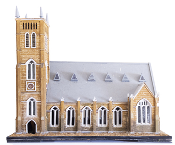
Artefact, Model of Church, C1900
This model of St. John’s Presbyterian Church in Warrnambool was made by Johan Carl August Landmann (1826-1920). August Landmann and his wife, Christina came from Silesia to Australia in 1854. They settled in Warrnambool where August made a living as a carpenter and joiner. At first he rented shops in Timor Street and then built a two-storeyed shop and residence in Henna Street. Landmann built many of the early commercial buildings and residences in Warrnambool and he and his family were associated with the management of the Warrnambool Western Brewery. When he retired in 1900 he built another residence in Mickle Street and it was at that time that it is believed he made the model of the Presbyterian Church and the model of the Ozone Hotel (which is in the Warrnambool Art Gallery today). St. John’s Presbyterian Church, designed by Andrew Kerr, was built in the English Gothic style and opened in 1875. It was destroyed by fire in 1920 but was rebuilt to a similar style. This model is of great significance for two reasons: 1. It was made by a prominent early Warrnambool carpenter and joiner, Johan Carl August Landmann. 2. It is the only known model of the Warrnambool St. John’s Presbyterian Church which was destroyed by fire in 1920.This model is on a wooden stand or base which is painted black with metal screws. The edging of the stand contains straw which is now brown but was originally green to resemble grass or lawn. The church is a wooden structure (hollow inside) with some sections painted to resemble sandstone. The roof is slanted and painted grey and has six dormer windows or ventilation pieces on each side. The main body of the church has a nave with dual arched windows, the west end has dual arched windows and a door with louvre ventilation and the east end has a door and dual arched windows and two conical-shaped finials. The windows, some of which are triangular, have frosted decorated glass. Some of the glass in the windows is missing. The main tower is square-shaped with four conical-shaped finials. The upper part has four sets of louvres and two arched windows. The centre and lower sections have rosette patterns and several sets of dual arched windows with frosted decorated glass panels. The north east corner has a smaller tower.johan carl august landmann, st. john’s presbyterian church, warrnambool, warrnambool history -
 Bendigo Historical Society Inc.
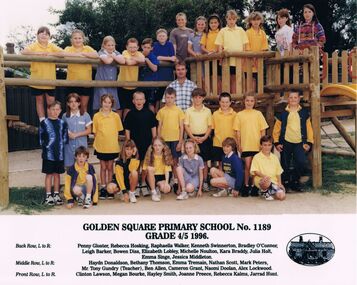
Photograph - GOLDEN SQUARE LAUREL STREET P.S. COLLECTION: GOLDEN SQUARE PRIMARY SCHOOL GRADE 4/5 1996
Laminated colour photograph of the Golden Square Primary School No. 1189 Grade 4/5 1996 classes. The photo is taken at a playground. Some of the children are in front of the timber structure and some are standing on it. The children are wearing a mixture of uniforms and everyday clothes. Under the photo is printed:- Golden Square Primary School No. 1189 Grade 4/5 1996. Their names are:- Back Row, L to R: Penny Gloster, Rebecca Hosking, Raphaella Walker, Kenneth Swinnerton, Bradley O'Connor, Leigh Barker, Bowen Diss, Elizabeth Lobley, Michelle Noulton, Kara Braddy, Julia Holt, Emma Singe, Jessica Middleton. Middle Row, L to R: Haydn Donaldson, Bethany Thomson, Emma Tremain, Nathan Scott, Mark Peters, Mr. Tony Gundry (Teacher), Ben Allen, Cameron Grant, Naomi Doolan, Alex Lockwood. Front Row, L to R: Clinton Lawson, Megan Bourke, Hayley Smith, Joanne Preece, Rebecca Kalms, Jarrad Hunt. On the right beside the names is an oval picture of the school.education, primary, golden square laurel st p.s., golden square laurel street p.s. collection - photograph - golden square primary school no. 1189 grade 4/5 1996, penny gloster, rebecca hosking, raphaella walker, kenneth swinnerton, bradley o'connor, leigh barker, bowen diss, elizabeth lobley, michelle noulton, kara braddy, julia holt, emma singe, jessica middleton, haydn donaldson, bethany thomson, emma tremain, nathan scott, mark peters, mr tony gundry (teacher), ben allen, cameron grant, naomi doolan, alex lockwood, clinton lawson, megan bourke, hayley smith, joanne preece, rebecca kalms, jarrad hunt -
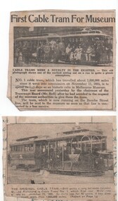 Melbourne Tram Museum
Newspaper, "First Cable Tram for Museum", 1940
Set of two newspaper cuttings regarding the first cable tram set in Melbourne. .1 - Original cutting and copy with a photo of the cable tram set 1 still operating in Melbourne - undated, notes it has been in daily use for 40 years - c1925. Has a photo of the tram showing its different support structure on the grip car. The cutting has been glued to a piece of scrap of paper which has handwriting on both sides in ink . A copy of the cutting has been trimmed in the corners. .2 - Cutting from a unknown Melbourne Newspaper - titled "First Cable Tram for Museum", reporting that cable car set 1 has been donated to the Melbourne Museum by the MMTB. Quotes the Chairman Mr. Bell. Noted that the car set was running on the Bourke St line. Cutting costs. 1940. Photo in cutting not of the cable car set itself. A short report appears in The Argus 29/11/1940, page 3, accessed 16-11-2016, that the cable car set was taken to the Museum of Victoria the previous day.trams, tramways, cable trams, museum, closure, donations, tram 1 -
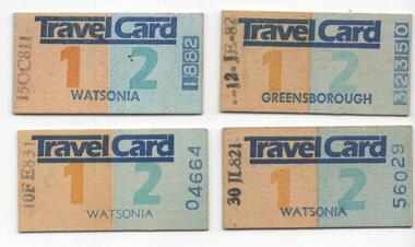 Melbourne Tram Museum
Ephemera - Ticket, Victorian Railways (VR), Zone 1 and 2, Travel cards for use from Watsonia and Greensborough Railway Stations, 1981 - 1983
Ticket - set of four paste board or cardboard - Zone 1 and 2, Travel cards for use from Watsonia and Greensborough Railway Stations. Have been dated stamped for periods during Oct. 1981 and Feb. 1983. Travelcard Note the ticket numbers - two from the Railway Printer and two from the Government printer. From http://www.robx1.net/victkt/zone123/html/tc.htm - accessed 2-2-2019 "Travelcard was the flagship of the new zonal system. It allowed unlimited, all day travel on trains, trams and buses - both Government and Private. It may be suggested that this was the beginning of much greater subsidies to the private bus operators to include them under the umbrella of Travelcard. As there was no longer a day return rail ticket, Travelcard was a de facto replacement, but the price structure did not disadvantage customers. Quite simply, Travelcard was a bonus no matter how it was used and it soon proved very popular; so much so that the term "Travelcard" was retained when the zones were replaced by the "Neighbourhood" system in 1983. " Ticket Nos: 1882, 4664, 32350, 56029trams, tramways, tickets, travel cards, the met, railways, public transport -
 The Beechworth Burke Museum
Photograph - Lantern Slide, c1900
This image shows a semi-aerial view of commercial and official properties lining Ford Street, Beechworth, in approximately 1900. The tower of Christ Church of St Peter and St Paul can be seen in the middle section of the photograph, on the left-hand side of the street. The Church was constructed in 1858 with the tower added to the structure in 1864. Lantern slides, sometimes called 'magic lantern' slides, are glass plates on which an image has been secured for the purpose of projection. Glass slides were etched or hand-painted for this purpose from the Eighteenth Century but the process became more popular and accessible to the public with the development of photographic-emulsion slides used with a 'Magic Lantern' device in the mid-Nineteenth Century. Photographic lantern slides comprise a double-negative emulsion layer (forming a positive image) between thin glass plates that are bound together. A number of processes existed to form and bind the emulsion layer to the base plate, including the albumen, wet plate collodion, gelatine dry plate and woodburytype techniques. Lantern slides and magic lantern technologies are seen as foundational precursors to the development of modern photography and film-making techniques.This glass slide is significant because it provides insight into Beechworth's built environment and commercial and official infrastructure in the early Twentieth Century, around the time of Australia's Federation into one nation. It is also an example of an early photographic and film-making technology in use in regional Victoria in the time period.Thin translucent sheet of glass with a square image printed on the front and framed in a black backing. It is held together by metals strips to secure the edges of the slide.burke museum, beechworth, lantern slide, slide, glass slide, plate, burke museum collection, photograph, monochrome, ford street, christ church of st peter and st paul, church tower, landmarks, 1900, shopping facilities, public buildings, 1900s, built environment, streetscape -
 Eltham District Historical Society Inc
Document - Property Binder, 907 Main Road, Eltham
Newspaper article: $6000 grant to Our Lady's, The Advertiser, July 2, 1996 - Grant given to Parish of Our LadyHelp of Christians which is taking over the use of the Eltham War Memorial Hall in Main Road and the Nillumbik After School Program. (Other items include: St Andrews Submission Re application to subdivide 1726 Heidelberg-Kinglake Road; Minister's decision awaited - A six-eight lot subdivision at Eagles Nest Road, Strathewen; Mt Pleasant Rd petition - Need for a shared pathway; Policy on ad signs - Amended policy on advertising signs for community events; Main Rd streetscape plan - Plans for streetscape improvement in Main Road to go on display; Special meeting dates set - Special meetings to consider formal submissions and then adopt a final proposal for Shire's electoral structure for Ministerial approval and gazettal. Letter Eltham District Historical Society to Nillumbik Shire Council, 16 September 1996: Proposed roundabouts Main Road Eltham at Dudley Street and Panther Place. Newspaper article: Diamond Valley News 16 October 1996, Pre-school welcomes plan for traffic lights.main road, eltham, property, roundabouts, dudley street, panther place, eltham pre-school, eltham war memorial -
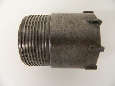 Kiewa Valley Historical Society
Drill Bit Diamond, circa mid to late 1900's
This hollow core bit has hard cutting inserts for drilling into rock. It was used to drill and recover 50mm diameter (most common size) rock cores. The rock cores were assessed by geologists and engineers to provide information for design of structures such as tunnels, dams and underground power stations (eg. McKay Creek Power Station, West Kiewa Power Station). This type of bit was also used where damage to the surrounding rock had to be minimised. The Diamond Drill Bit,used in the early 1900's, when it was primarily used as a method of sampling rock for ore deposits and oil exploration resulting in a "coring" of rock. The use of "coring" to obtained samples for the SEC Kiewa Hydro Electricity Scheme(1920's onward) was to analyse the core to obtain temperature and rainfall patterns shown by the levels of layered solidified soil(rock). This diamond drill would have been used in the early 1900's to provide a sub strata map of temperature and water patterns (over an long period of time). This was a pre requisite to any decisions about the viability of the region to provide the water needed for a successful hydro electricity scheme.This diamond drill for core sampling was at the forefront of the analysis whether to construct a hydro electrical facility in the Kiewa Valley and the adjoining alpine region. The rock core samples produced were assessed by geologists and structural engineers. It was only after extensive core drilling covering the region that solid scientific evidence could be provided to start the "SEC Vic Hydro Electricity Scheme" within its current boundaries.This "diamond" drill bit has eight "teeth" at its cutting edge. The drill creates an 55mm hole in extremely hard rock material to obtain 50mm core samples.. Three quarters down the shank it has thread screw channels to attach the bit to the drill pipe. The coring pipe attaches via screwing it onto this bit. Core samples are the main objective of this tool.alternate energy supplies, alpine feasibility studies temperature, rainfall, sec, kiewa hydro electric scheme, electricity -
 Flagstaff Hill Maritime Museum and Village
Equipment - Company seal embosser, Unknown
The former Albion (West) Woollen and Worsted Mills is a functional structure which has been built in stages, possibly dating from the 1880s, with the earliest sections near to the Barwon River.The Worsted mill operated for about 50 years and at its peak employed around 500 people. In 1973 the mill merged with the British John Foster and Sons Company under some controversial stock and shareholding issues. The mill continued for a short period before closing at a time when much of the Australian textile industry was finding it difficult to compete with overseas operations. In the 30 plus years after the closure, the site was used for several ventures, including the Mill Vintage Markets and a vehicle trim manufacturing operation. In 2011 the site was purchased by Little Creatures of Western Australia to become their main brewery for the eastern states of Australia. Now owned by the Lion Group, Little Creatures started their 60 million dollar transformation of the old mill in 2012. Finally, in 2013 these former walls of industry were soon rattling away to the sounds of a different type of industry, as the first bottles of beer made their way out of the Geelong Little Creatures Brewery. The remaining building of the former Albion Woollen and Worsted Mills has historical significance as one of Geelong's major woollen mills. The venture has operated on the same site for more than a century. The Albion Woollen Mill was one of the four key sites along with Victoria, Barwon and Union Mills that was established in the late 1860s to mid-1870s. These mills were in constant operation on the west side of the Barwon Bridge over the last century and led to Geelong's fame as milling and scouring locality. The Albion Mill was probably the most successful survivor of the early private company operations. It was regarded as a model mill in the late 1880s and was, from all accounts, well-planned and organised with machinery on a par with the great mills of England. It produced high-quality tweeds. Together with the (now demolished) Union Mill it was regarded as the borough's principal industry over the 1870-1900 period and was one of Australia's most significant producers of tweed by 1900. These two mills were more successful, competitive and long-lived than the Barwon and Victoria Mills. The remaining building form is an important reminder of the private ventures of both the Albion and Union Mills and represents a key site of spinning, carding and finishing as well as scouring and dying that occurred in the lower section near to the river. The loss of the adjacent former Union Mill is unfortunate because the complex, together with the former Collins Union Mill office building, was an important reminder of the success of these industries and the reputation they earned for the Geelong region as a centre for quality textile products. Company seal embosser hand operated matte black & brass colour Western District Worsted Mills emblem on frontflagstaff hill, warrnambool, shipwrecked-coast, flagstaff-hill, flagstaff-hill-maritime-museum, maritime-museum, shipwreck-coast, flagstaff-hill-maritime-village -
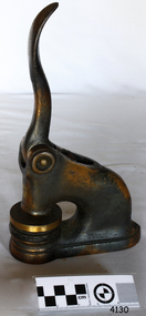
 City of Moorabbin Historical Society (Operating the Box Cottage Museum)
Tools, hammer upholstering, c1900
A hammer is a tool with a heavy head and a handle, often made of shock absorbent wood or fibreglass, that is used to strike an object. The most common use for hammers are to drive nails, fit parts, forge metal and break apart objects. Hammers vary in size, shape and structure, depending on their uses. Hammers are basic tools in many trades. A hammer is composed of a head, most often made of steel and handle also called a helve or haft. Most hammers are hand tools. A traditional hand-held hammer consists of a separate head and handle, fastened together by means of a special wedge made for the purpose, or by glue, or by both . This 2 piece design is often used to combine a dense metallic striking head with a non-metallic mechanical shock absorbing handle - to reduce user fatigue from repeated strikes. If wood is used for the handle, it is often ash or hickory, which are tough and long lasting materials that can dissipate shock waves from the hammer head. This upholsterer’s hammer has one end of the steel head rounded for knocking nails into wood furniture. The other end is divided to form a 2 pronged claw for withdrawing nails. . An upholsterer's hammer with a steel head and wooden handle, The steel head has one rounded end and a clawed endpioneers, early settlers, market gardeners, moorabbin, bentleigh, cheltenham, brighton, tools, craftsman, carpenters, cabinet makers, blacksmiths, builders, woodwork -
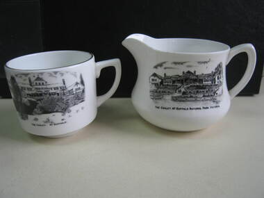 Parks Victoria - Mount Buffalo Chalet
Crockery
The jug and cup were purchased from a second - hand shop in Bairnsdale. Jug is older than cup as the chalet is represented as a single storey structure. The cup is later as the second storey appears in the illustration. 'Souvenirs in relation to the Chalet and Mount Buffalo wee first mention in December 1912... A large range of souvenirs has since been associated with the Chalet and Mount Buffalo from crafted wooden items, silver spoons, cups etc... The collection includes a broad selection of products that have been sold throughout much of the Chalet's history, each representative of the transient fashions of their period.' (Pg. 114. Historica) 'A group of tableware items is notable for its black transfer printed decoration, which features the Chalet building. Interestingly, the printed designs represent the Chalet at two different stages in its building history under the Victorian Railways, in 1926 after completion of the north wing, and 1937-39, after the second storey is added to the front.. manufactured in England by A.B. Jones and sons, a Stoke on Trent pottery firm which operated under the trade name of Grafton China between 1900-1972.' (Pg. 114. Historica)Listed in Draft Inventory of Significant Collection Items . Appendix A.3. Souvenirs. (Pg 168. Historica)..1] Ceramic jug. Souvenir of Mt Buffalo. White ceramic squat milk jug with a black transfer illustration/drawing on front side. Picture is of the MtBuffalo Chalet from the front. Some worn gold glaze detail. It appears to be a single story building with a planted garden at the front with a fence. Trees to one side and people walking up steps. "THE CHALET, MT BUFFALO NATIONAL PARK, VICTORIA." is written under the illustration. Jug has a faint crack. .2] White ceramic cup with gold edging around top of cup. Black transfer drawing of the chalet with a second storey. Rocks and tree in foreground and "THE CHALET. MT BUFFALO." underneath transfer. .1] "THE CHALET, MT BUFFALO NATIONAL PARK, VICTORIA." is written under the illustration. On the base of the jug, with sun motif, "ENGLAND / GRAFTON CHINA /A / B J / & SONS / LOFTUS MORA / PTY. LTD" .2] "THE CHALET. MT BUFFALO." underneath transfer. Under cup, "A.B.J. / GRAFTON / CHINA / MADE IN / ENGLAND" -
 Ringwood and District Historical Society
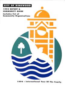
Book, City of Ringwood, City of Ringwood 1994 Report & Community Guide, 1994
The City of Ringwood and the City of Croydon merged in December 1994 and became the City of Maroondah.Community information book issued by City of Ringwood for 1994 - covering the facilities and activities of the Ringwood Council and other local organisations and associations. Includes Ringwood Public Golf Course discount vouchers and two Ringwood Aquatic Centre bonus entry vouchers.CONTENTS: (page no.) Contents A Message from the Mayor - Cr. Margaret Cheevers 3 Your Council 4 Local State and Federal MPs 5 Council Meetings and Elections 6 History of Ringwood 7 City Manager's Report 8 Organisational structure 9 Human Services 10-19 Environmental Health 20-21 Ringwood Library 22 Parks and Gardens 23 Ringwood's Parks and Reserves 24 Building 25 Engineering Planning Services 26-28 Waste Management 29 Town Planning 30 Traffic and Local Laws 31-33 Roads, Drainage and Major Works 38-39 Halls and Facilities 40-41 Aquatic Centre 42 Convention Centre/Karralika Theatre 43 Golf Course 44 Free Swim & Golf Discount Vouchers 45 Community Organisations 46-64 Finance 65-66 Administration 67 Community Liaison 68 Information Systems 69 Personnel 70-71 Risk Management 71 Rates and Valuations 72 rinx -
 The Beechworth Burke Museum
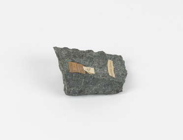
Geological specimen - Greenstone / Gabbro, Unknown
This specimen was recovered from Ceres West of Geelong, Victoria. Greenstone is the name for any metamorphosed basic igneous rock (in the case of this specimen, Gabbro) that gains its greenish colour to the presence of the minerals chlorite, actinolite, or epidote, hence the term 'green' and 'stone'. Greenstone is often formed through metamorphsis along a convergent plate boundary. In the rock cycle (the series of processes that creates the various types of rocks) there are identified three different types of rocks, which are the sedimentary, the igneous and the metamorphic. Metamorphic rocks started out as sedimentary, igneous or earlier metamorphic rocks but changed from their original condition under the effect of high heat, high pressure or hot, mineral-rich fluid. However, if pressure or heat is too high, then the rock will melt, resulting in the formation of an igneous rock. The name used to describe these types of rocks reflects this specific inherent trait of change, since the word “metamorphic” derives from the Greek word “metamorphosis”, meaning “change of form or structure”. Metamorphic rocks form in the Earth`s crust but can be also found on the surface, due to elevation of the Earth`s surface. They are divided into two categories: the foliated metamorphic and the non-foliated metamorphic rocks. Gabbro is a highly useful mineral that is often polished to create cemetery markers and kitchen benches. It is notable for its qualities of durability, being able to withstand extreme elements and wear. Whilst not rare, Gabbro is of great utility and has been highly desirable for its qualities. This specimen is part of a larger collection of geological and mineral specimens collected from around Australia (and some parts of the world) and donated to the Burke Museum between 1868-1880. A large percentage of these specimens were collected in Victoria as part of the Geological Survey of Victoria that begun in 1852 (in response to the Gold Rush) to study and map the geology of Victoria. Collecting geological specimens was an important part of mapping and understanding the scientific makeup of the earth. Many of these specimens were sent to research and collecting organisations across Australia, including the Burke Museum, to educate and encourage further study.Greenstone is a solid hand-sized metamorphic mineral of a green colour. Greenstone is the name for any metamorphosed basic igneous rock (in the case of this specimen, Gabbro) that gains its greenish colour to the presence of the minerals chlorite, actinolite, or epidote, hence the term 'green' and 'stone'. Gabbro is a medium to coarse grained rocks that consist primarily of plagioclase feldspar and pyroxene. Greenstone is often formed through metamorphsis along a convergent plate boundary. Gabbro forms due to cooling and crystallization of magma underneath Earth's surface. Greenstone/Gabbro/from Ceres west/of Geelong. Has old Geological Survey label/and probably collected by/Richard Daintree in 1861/C.Willam 15/4/21/ Other label: 62 /greenstone, metamorphosed, igneous rock, gabbro, chlorite, actinolite, epidote, metamorphsis, rock cycle, various types of rocks, sedimentary, high heat, high pressure, mineral-rich fluid, metamorphosis, foliated metamorphic, non-foliated metamorphic, convergent plate boundary, greenish colour, minerals -
Bendigo Historical Society Inc.
Booklet - Fortuna Villa Tour Guide, abt 2013
In 1871, the Villa and the associated ‘180 Mine’ on the New Chum Reef was bought by George Lansell who had become successful in his gold mining interests and investments. With his continuing success in deep mining, Lansell undertook major extensions to his home, and in fact continued this expansion and decoration of Fortuna until his death almost 40 years later. Fortuna Villa remains remarkably intact as a house even though it has served as a busy workplace for 65 years. Stained glass, elaborate ceilings, grand cedar and blackwood staircase, solid marble baths, extensive acid-etched glasswork (conservatory) are some of the architectural features that contribute to the outstanding ‘feel’ of the structure. The Fortuna grounds cover some 7.57 ha. and feature an ornamental lake, garden, a ‘Roman-Bath’ and the ‘Pompeii Fountain’. The original quartz-crushing battery building, stables and coach house remain close to the main villa. The magnificent villa itself is the aspirational centerpiece to this remarkable property. It is set in botanic-style gardens featuring established trees. George Lansell’s historic talisman has hosted some iconic characters itself, including leaders and diplomats, Dame Nellie Melba and even HRH the Prince of Wales and the Duke of Edinburgh.Fortuna Villa Tour Guide, seven pages - Photos, History and guide with description for each room or aspect. Chronology on back cover.history, bendigo, fortuna, george lansell -
 Parks Victoria - Gabo Island Lightstation
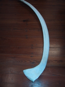
Whale bones
Whale bones found in harbour area. Dr Imlay operated a whaling outpost in Santa Barbara Bay in the early 1800's. John Morris ventured into whaling in 1848. The success of these ventures is not known. Retrieved from the Gabo Island Harbour in 1999, the collection’s two venerable whalebones are reminders of the whaling industry that was associated with Gabo Island prior to construction of the lightstation. Evocative relics of this long ceased activity, they are now also symbolic of today’s concern for protecting and saving whales. The whalebones are the only known artefacts in the collection that illustrate the period when European sealers and whalers intermittently used the island for their activities. The Imlay brothers, who operated from Twofold Bay, Eden NSW, used the island as a base and lookout up until about 1846, and several huts were erected.Whaling was last associated with the island in 1848, when John Morris surreptitiously ventured into this activity while being paid to erect lightstation buildings for the NSW government. Gabo’s historic jetty store, which stands as the oldest structure on the island, was thought to be built by Morris and is possibly associated with the activities that led to his dismissal. The whalebones were recovered from the harbour, close to the location of the store and the site of the former whaling outpost. The bones have first level contributory significance as evidence of the island’s whaling activities, which pre-date the history of the lightstation.1. Whale vertebrae, bleached white. 2. Whale bone, (rib) bleached white. -
 Falls Creek Historical Society
Document - Bob Hymans' Correspondence Collection
Bob (Herman) Hymans (a former member of the Royal Netherlands Navy) was born in Bloemendaal, Holland on 30th September 1922. During World War II he fought against the Japanese in the Dutch East Indies (now Indonesia) and was imprisoned in Changi and on the Burma Railway. After gaining qualifications as a Ski Instructor, Bob arrived in Falls Creek in July 1950. Working as an Instructor and Supervisor at Bogong Lodge, Bob decided his future was in accommodation. He was successful in negotiating an indenture for land from the State Electricity Commission (SEC). It took Bob two years to build his Grand Coeur Chalet but, tragically, it was burned down in August 1961. Bob also built the first Chairlift in Australia. This was a single chairlift and the structure was built from wooden electricity poles. He was constantly full of new ideas and proposals for the village. Bob Hymans died on 7th July 2007. This collection of between 200 - 300 items includes documents from Bob Hymans' correspondence whilst he was pioneering developments at Falls Creek, Victoria. It consists of Aerogrammes, telegrams, maps and communication with American and French companies related to issues ranging from licences, ski tows, international visits and developments at Falls Creek.This Collection is significant because it contains correspondence records of a Falls Creek pioneer who played an active role in the development of Falls Creek Village, including the first ski lift as well as Grand Coeur and Four Seasons lodges.A collection of letters and other documents from the personal records of Bob Hymansbob hymans, falls creek pioneers -
 Falls Creek Historical Society
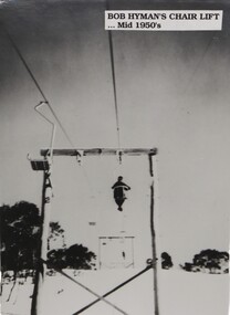
Photograph - Bob Hymans' Chair Lift, c1950s
This photo is from the private collection of George Shirling of Red Onion, Falls Creek. It is an image of the first Chair Lift built in Australia by Bob Hymans. This was a single chair lift and the structure was built from wooden electricity poles. George Shirling arrived in Falls Creek in 1962. He engaged Phil Nowell to build the original Koki Alpine Lodge which opened in 1965 with 14 beds. George operated the lodge with Michael “Baldy” Blackwell as manager. He also graduated in sport psychology in 1981 and was invited to become team psychologist for the Australian Winter Olympic team which went to Albertville, France, in 1992. He later owned the Red Onion Chalet. George credited the success of Koki to “Baldy” Blackwell. “Baldy” and Phil Nowell started the Trackers Mountain Lodge in partnership during the 1980s. In 1971 George sold Koki Lodge to Sigi Doerr. In 2024 the renamed Koki Alpine resort remains a highly popular destination in Falls Creek. George Shirling passed away on 27th February 2023. He had remained actively involved in Falls Creek and was generous with his time and knowledge, always an amazing supporter of The Falls Creek Museum and Falls Creek Village.This photo is significant because it features the first chair lift built at Falls Creek, Victoria.A black and white image of a skier riding on Bob Hymans' first chair lift at Falls CreekOn Label: BOB HYMANS' CHAIR LIFT Mid 1950sgeorge shirling, bob hymans' chair lift, bob hymans -
 Bendigo Military Museum
Document - CENOTAPH RESTORATION BENDIGO, City of Bendigo, C.1984
This Document is the first in several plus photos and an article following the restoration of the Bendigo Cenotaph (Replica of the Cenotaph in Whitehall London). The letter is from the City of Bendigo Municipal Offices Lyttleton Terrace Bendigo is dated 13th April 1984 from the Building Surveyor Mr P.W. Phillips to Mr J.K. Barnes Secretary Bendigo RSL Sub Branch P.O.Box 449 Bendigo. Letter states that the Surveyors Report was adopted by Council on 21st November 1983 and would then be considered at Estimates later in the year. The Surveyors Report pages 2/3 gives a background report back to 1976 re its condition by the Building Surveyor at the time Mr R.H. Chellow and that an offer to fund at no cost was offered. Unfortunately this did not proceed. Council had approved funds for Stone work etc in the 1976/77 Estimates. The report is under several headings “Restoration of Cenotaph” being the history to this point. “Nature of Repairs Neccessary” - in brief, Extensive repairs, Granite structure is good, Sandstone needs 90% replacement, brick core in good order. “Estimate of Cost” A price of $30,000 for Budget purposes but could be as low as $25,000. “Recommendation” That Restoration be referred to the 1984/85 Estimates for consideration, copies to Bendigo RSL and State President RSL.Document 3 pages stapled together, front page is A4 and the pages 2/3 is Foolscap.Front page has a top section in blue, on the left is a depiction of a Mine Poppet Head, on the right is a Coat of Arms. The letter section is in black type, signed at the bottom in blue pen. Pages 2/3 are all black print.Page 1 points, Coat of Arms, “City of Bendigo - Progress”. “1968/84” - PWP:LT 32.7.1”. Page 2/3, “Building Surveyors Report - 21st November 1983 - B42/83 - (32.7.1)”brsl, smirsl, cenotaph, restoration -
 National Wool Museum
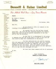
Letter - Report, Wool Classing Clip Report, 1965-1966
The National Wool Museum accepted a donation from Brian Licence in 2022 of several mementoes relating to his career in the wool industry. Brian studied Wool Classing and worked for a decade in this profession before moving to Melbourne which required him to change careers. These Wool Classing Clip Reports date from 1965 to 1966, there are 7 total. The reports give feedback to the wool classer about their clips recently classed. They include some suggestions as to how a wool classer may improve their performance, and how a wool grower may be able to increase profits from their flock.8 sheets of paper, slightly under a4 size at 260 x 205 mm. 4 sheets have a header from Elder Smith Goldsbrough Mort Limited, 2 from Bennett & Fisher Limited, and 1 from Roberts, Stewart & Company Limited. All Wool Classing Clip Reports have the same structure, a header from the sending company, a body paragraph of black ink from a typewriter, concluding with a signature at the bottom of the page. Some of the pages have yellowed with age, others have slight tears. Report 1 is by Elder Smith Goldsbrough Mort Limited. It is dated 4th March, 1965. Report 2 is by Bennett & Fisher Limited. It is dated 7th October, 1965. Report 3 is by Bennett & Fisher Limited. It is dated 11th July, 1966. Report 4 is by Roberts, Stewart & Company Limited. It is dated 12th July, 1965. Report 5 is by Elder Smith Goldsbrough Mort Limited. It is dated 9th November, 1965. Report 6 is by Elder Smith Goldsbrough Mort Limited. It is dated 5th July, 1965. Report 7 is by Elder Smith Goldsbrough Mort Limited. It is dated 26th October, 1965.Multiple. See Multimediawool classing -
 Moorabbin Air Museum
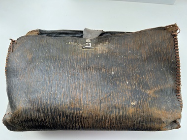
Accessory (Item) - Leather Satchel Marked With Associated Airlines - Melbourne
-
 The Beechworth Burke Museum
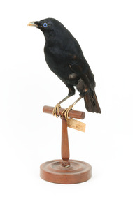
Animal specimen - Australian Hobby, Trustees of the Australian Museum, 1860-1880
Hobbies are mainland birds that prefer to spend their time in forests and woodlands. They are widespread in Australia's colder eastern states, particularly Adelaide, Victoria, and Southern NSW. With a diet of bats, insects, and small birds, they use their refined wing structure, which is long and narrow in shape, more suited to speed than precision, and sharp reflexes to catch prey in mid-flight. Because they are members of the Falconidae and Falconiformes raptor families and have similar characteristics, they are frequently confused with their relative, the Peregrine Falcon. Close inspection reveals that they are half the size and have a more pronounced dark masking around the eyes. This specimen is part of a collection of almost 200 animal specimens that were originally acquired as skins from various institutions across Australia, including the Australian Museum in Sydney and the National Museum of Victoria (known as Museums Victoria since 1983), as well as individuals such as amateur anthropologist Reynell Eveleigh Johns between 1860-1880. These skins were then mounted by members of the Burke Museum Committee and put-on display in the formal space of the Museum’s original exhibition hall where they continue to be on display. This display of taxidermy mounts initially served to instruct visitors to the Burke Museum of the natural world around them, today it serves as an insight into the collecting habits of the 19th century.This specimen is part of a significant and rare taxidermy mount collection in the Burke Museum. This collection is scientifically and culturally important for reminding us of how science continues to shape our understanding of the modern world. They demonstrate a capacity to hold evidence of how Australia’s fauna history existed in the past and are potentially important for future environmental research. This collection continues to be on display in the Museum and has become a key part to interpreting the collecting habits of the 19th century.The Australian Hobby is a medium-sized bird with a falcon-like appearance, long wings, and a commanding posture and presence. This bird has a distinctive brown/black helmet on its head, as well as a mask-like face that is highlighted by the prominent white half collar. Over the top of reddish brown underpart feathers, streaks of black lined patterns decorate the protruding chest. With its squared off tail feathers, the bird's back is dark brown and appears elongated and domineering. It is perched on a wooden stand and is secured with wire that does not obscure the talons.No swing tagtaxidermy mount, taxidermy, animalia, burke museum, beechworth, australian museum, skin, reynell eveleigh johns, bird, australian birds, falcon, falconidae, falconiformes, peregrine falcon -
 The Beechworth Burke Museum
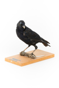
Animal specimen - Satin Bowerbird, Trustees of the Australian Museum, 1860-1880
The Satin Bowerbird is a medium-sized common bird found from Queensland to Victoria in rainforests and wet sclerophyll forest. During the summer, the diet consists mostly of fruit, with insects as a supplement. They're famous for their courtship behaviour and for decorating stick-structured nests with blue sparkling objects. With it's stunning glossy blue-black feathers, which evolve from green-brown in appearance, this Satin Bowerbird is more than seven years old, and therefore not any younger as they are often mistaken for females, which are supposed to look like the green catbird. The eyes of this mature male are violet-blue, and the bill is pale bluish white. This specimen is part of a collection of almost 200 animal specimens that were originally acquired as skins from various institutions across Australia, including the Australian Museum in Sydney and the National Museum of Victoria (known as Museums Victoria since 1983), as well as individuals such as amateur anthropologist Reynell Eveleigh Johns between 1860-1880. These skins were then mounted by members of the Burke Museum Committee and put-on display in the formal space of the Museum’s original exhibition hall where they continue to be on display. This display of taxidermy mounts initially served to instruct visitors to the Burke Museum of the natural world around them, today it serves as an insight into the collecting habits of the 19th century.This specimen is part of a significant and rare taxidermy mount collection in the Burke Museum. This collection is scientifically and culturally important for reminding us of how science continues to shape our understanding of the modern world. They demonstrate a capacity to hold evidence of how Australia’s fauna history existed in the past and are potentially important for future environmental research. This collection continues to be on display in the Museum and has become a key part to interpreting the collecting habits of the 19th century.Satin Bowerbirds are medium-sized birds. The adult male has striking glossy blue-black plumage, a pale bluish white bill and a violet-blue iris.47a / Satin Bower-bird / See Catalogue, page 16 /taxidermy mount, taxidermy, animalia, burke museum, beechworth, australian museum, skin, reynell eveleigh johns, bird, satin bowerbird, bowerbird -
 The Beechworth Burke Museum
Animal specimen - Satin Bowerbird, Trustees of the Australian Museum, 1860-1880
The Satin Bowerbird is a medium-sized common bird found from Queensland to Victoria in rainforests and wet sclerophyll forest. During the summer, the diet consists mostly of fruit, with insects as a supplement. They're famous for their courtship behaviour and for decorating stick-structured nests with blue sparkling objects. With it's stunning glossy blue-black feathers, which evolve from green-brown in appearance, this Satin Bowerbird is more than seven years old, and therefore, not any younger as they are often mistaken for females, which are supposed to look like the green catbird. The eyes of this mature male are violet-blue, and the bill is pale bluish white. This specimen is part of a collection of almost 200 animal specimens that were originally acquired as skins from various institutions across Australia, including the Australian Museum in Sydney and the National Museum of Victoria (known as Museums Victoria since 1983), as well as individuals such as amateur anthropologist Reynell Eveleigh Johns between 1860-1880. These skins were then mounted by members of the Burke Museum Committee and put-on display in the formal space of the Museum’s original exhibition hall where they continue to be on display. This display of taxidermy mounts initially served to instruct visitors to the Burke Museum of the natural world around them, today it serves as an insight into the collecting habits of the 19th century.This specimen is part of a significant and rare taxidermy mount collection in the Burke Museum. This collection is scientifically and culturally important for reminding us of how science continues to shape our understanding of the modern world. They demonstrate a capacity to hold evidence of how Australia’s fauna history existed in the past and are potentially important for future environmental research. This collection continues to be on display in the Museum and has become a key part to interpreting the collecting habits of the 19th century.Satin Bowerbirds are medium-sized birds. The adult male has striking glossy blue-black plumage, a pale bluish white bill and a violet-blue iris.Swing tag: National Museum Victoria / Satin Bowerbird / Ptilonorhynchus Violaceus / B2027 / (Vieillot) / W. Shaw Collin. / Mount: PTILONORHYNCHUS / VIOLACEUS / SATIN BOWERBIRD / taxidermy mount, taxidermy, animalia, burke museum, beechworth, australian museum, skin, reynell eveleigh johns, bird -
 The Beechworth Burke Museum
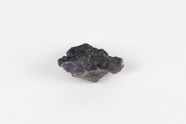
Geological specimen - Fluorite (purple)
Fluorite comes in a variety of natural colours and crystal formations and glows under ultraviolet light (the word 'fluorescence' comes from the same etymological source). In its pure form, calcium fluoride, it is a colourless combination of the elements calcium and fluorine, but gains its colour from trace elements that infiltrate or replace calcium within its crystal structure during its formation. Although fluorite crystals polish well and can achieve a high level of lustre, the mineral is very soft (4 on MOHS hardness scale) so it is unsuitable for use in rings and must be handled and stored carefully if used in other forms of jewellery. Most crystals of the mineral are too coarse for decorative purposes but have been mined under the name fluorspar for a variety of commercial and industrial purposes. These include the production of hydrofluoric acid, smelting metal alloys, producing glazes and ceramic finishes and use in medical and dental products. An existing label for this specimen indicates that its origin or collection-point was 'probably USA.' Fluorspar, the form of fluorite used commercially and industrially, was mined in significant quantities in the counties of Hardin and Pope in South-Eastern Illinois throughout the Nineteenth and Twentieth Centuries. Fluorite was made Illinois' state mineral in recognition of its contribution to the state's identity and economy. The specimens are significant as examples of surveying activity undertaken to assess and direct the development of the mineral resource industries, as well as the movement to expand human knowledge of earth sciences such as mineralogy and geology in the nineteenth century.The specimen is a piece of purple shaded fluorite (also known as fluorspar), the mineral form of calcium fluoride. The unpolished specimen presents a dark purple interior with a substantial dark grey crust representing the matrix from which the specimen was obtained. Existing label: Flourite / (purple) / probably / USA / BB /burke museum, beechworth, geological, geological specimen, fluorite, flourite, calcium fluoride, hydrofluoric acid, jewellery, indigo shire, north-east victoria, mining, illinois, usa, united states, fluorine, gemstones, purple stones -
 Orbost & District Historical Society
black and white photograph, C1900
The first settler to occupy the Marlo township area was James Stirling around the year 1875. He built a bark hut on the bluff that had two rooms, bark walls, earthen floors and a shingle roof. By 1884, this structure had expanded to a 9 roomed accommodation house and in 1886 became the Marlo Hotel when a liquor license was granted. The Governor-in-Council declared Marlo to be a township on 18 February 1889. During May 1889, the government surveyor, E.L. Bruce set out 19 sections of the new township, with the first sales of subdivided land occurring the following May. At this time, Stirling's Marlo Hotel was the unofficial hub for the community. It was a general store, accommodation house and the unofficial post office, with settlers taking turns in bringing the mail from Orbost or Cunningham. This continued until Aug 1942, and in 1969 was located in a house adjacent to the Marlo Hotel, before being transferred to the Marlo General Store in this year. The official Post Office List states the Marlo Post Office opened around 1902. in 1925, the "Marlo House" (a nine room accommodation guest house) was granted a liquor licence. The "Marlo House" became "The Marlo Hotel". The Marlo Hotel was popular with many Orbost and district settlers, who travelled to Marlo by horseback or buggy. The Marlo Hotel, perched on the hill overlooking the estuaries and the entrance is a significat building in Marlo. Established in 1886, it has been operating for over 120 yearsA black / white photograph of the Marlo Hotel. Patrons are standing on the verandah and lawns. A horse-drawn carriage is on the left. The photograph is on a green buff card with a rough edge on R H side.on back - " Old Marlo Hotel"marlo-house marlo-hotel stirling-james -
 Orbost & District Historical Society
black and white photograph, C 1900
The first settler to occupy the Marlo township area was James Stirling around the year 1875. He built a bark hut on the bluff that had two rooms, bark walls, earthen floors and a shingle roof. By 1884, this structure had expanded to a 9 roomed accommodation house and in 1886 became the Marlo Hotel when a liquor license was granted. The Governor-in-Council declared Marlo to be a township on 18 February 1889] During May 1889, the government surveyor, E.L. Bruce set out 19 sections of the new township, with the first sales of subdivided land occurring the following May. At this time, Stirling's Marlo Hotel was the unofficial hub for the community. It was a general store, accommodation house and the unofficial post office, with settlers taking turns in bringing the mail from Orbost or Cunningham. This continued until Aug 1942, and in 1969 was located in a house adjacent to the Marlo Hotel, before being transferred to the Marlo General Store in this year. The official Post Office List states the Marlo Post Office opened around 1902. in 1925, the "Marlo House" (a nine room accommodation guest house) was granted a liquor licence. The "Marlo House" became "The Marlo Hotel". The Marlo Hotel was popular with many Orbost and district settlers, who travelled to Marlo by horseback Perched on the hill overlooking the estuaries and the entrance, the Marlo Hotel is a significant building in Marlo. It was established in 1886 and has been operating for over 120 years,A black / white photograph of Marlo House with staff and patrons standing and sitting on the verandah.on front - "H.S. Marlo House"marlo-house marlo-hotel -
 Federation University Historical Collection
Document - Document - Course Outline, VIOSH: Ballarat College of Advanced Education; General Information - Graduate Diploma in Occupational Hazard Management, c1986
Victorian Institute of Occupational Safety and Health (VIOSH) Australia is the Asia-Pacific centre for teaching and research in occupational health and safety (OHS) and is known as one of Australia's leaders in the field. VIOSH has a global reputation for its innovative approach within the field of OHS management. VIOSH had its first intake of students in 1979. At that time the Institution was known as the Ballarat College of Advanced Education. In 1990 it became known as Ballarat University College, then in 1994 as University of Ballarat. It was 2014 that it became Federation University. VIOSH Australia students are safety managers, senior advisors and experienced OHS professionals. They come from all over Australia and industry. Students are taught active research and enquiry; rather than textbook learning and a one-size fits all approach. VIOSH accepts people into the Graduate Diploma of Occupational Hazard Management who have no undergraduate degree - on the basis of extensive work experience and knowledge. Document is General Information on the Graduate Diploma in Occupational Hazard Management. Sections are from a larger fully detailed document. Outlines the structure of the course, Unit Descriptions, Staff, Student Workloads. Student Enrolment Statistics for 1979 to 1985 show the numbers from each state and overseas, employments areas such as government, industry, manufacturing, health, and associations, plus the total applications and enrolments. Thirteen A4 sheets - typed on both sides.viosh, victorian institute of occupational safety and health, ballarat college of advanced education, graduate diploma in occupational hazard management, pg1, objectives of course, admission requirements, structure of course, unit descriptions, student workloads, assessment methods, k brown, dennis else, r gillis, tom norwood, max brooke, r kemp, j harvey, p kelly, l roberts, m torode, derek viner, eric wigglesworth, g fernandez, b lees, r maud, p swan, j blitvich, g bradley, j castleman, r lang, j lowinger, p reid