Showing 31209 items
matching building a
-
 Charlton Golden Grains Museum Inc
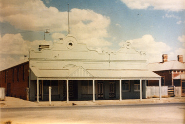
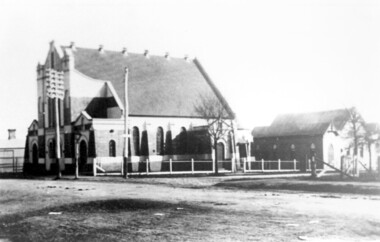
Photograph, Victoria Hall, Armstrong St Charlton c. 1960
Victoria Hall, Armstrong St Charlton was built for E. Miles in 1884. Sid Rosewall's house is on the right. This photo taken c. 1960.Colour photograph of a single storey, triple fronted red brick building. The front of the building is painted. There are double doors for the main entrance and three single doors - one to the left and two to the right of the main doors. There is a large, ornamental parapet wall on the front of the building with a flag pole. A wide verandah runs the length of the front of the building with a pitched section over the main entrance. The LH side of the building is unpainted and has four windows high on the wall. A red brick building is partially visible on the RH side of the photo. It has two chimneys and iron roof.victoria hall armstrong st charlton, e. miles, s. rosewall -
 Kew Historical Society Inc
Slide - 'Burke Hall', Nolan Avenue, 1976
Colour transparency (slide) created in June 1976 during a tour by the Junior National Trust, which was led by members of Kew Historical Society. The collection of 21 slides reveals that the tour covered all parts of Kew, but focused understandably on heritage buildings and sites.Image of an historic place in Kew that can be dated to an exact time and place. The images, albeit amateurish in composition, frequently reveal aspects of important buildings and sites that have changed over time.35mm colour transparency of Burke Hall (formerly Studley House, Waverley) showing the front facade facing south away from Nolan Avenue and Studley Park Road. Now Xavier Junior School, the Victorian Heritage Register describes the building as: "...a largely intact mansion commenced in the mid-Victorian period that was sympathetically added to during the nineteenth century and as such, is one of the key Victorian buildings to have been built in Kew. the historical associations with figures such as Charles C. Staples and Carl Pinschof enhance the significance, while the additions made to the house in recent years detract from it."historic houses -- kew (vic.), nolan avenue -- kew (vic), xavier college -- kew (vic.), burke hall, waverley, studley hall -
 Kew Historical Society Inc
Slide - 'Studley House', Nolan Avenue, 1976
Colour transparency (slide) created in June 1976 during a tour by the Junior National Trust, which was led by members of Kew Historical Society. The collection of 21 slides reveals that the tour covered all parts of Kew, but focused understandably on heritage buildings and sites.Image of an historic place in Kew that can be dated to an exact time and place. The images, albeit amateurish in composition, frequently reveal aspects of important buildings and sites that have changed over time.35mm colour transparency of Studley House in Nolan Avenue, Kew, now part of Xavier Primary School. The Victorian Historic Buildings Register describes the building as: ""Studley House", 15 Nolan Avenue Kew is an early house, extensively added to, which is of architectural importance in its present form and has important historical associations with John Hodgson, an early settler in the district and with subsequent owners. The first part of the house is an early and particularly fine example of the Italianate style in Victoria. The later additions dwarf the original house but are of interest in their own right. Plaster and woodwork internally and some stained glass are notable."historic houses -- kew (vic.), nolan avenue -- kew (vic), xavier college -- kew (vic.), studley house -- nolan avenue -- kew (vic.) -
 Federation University Historical Collection
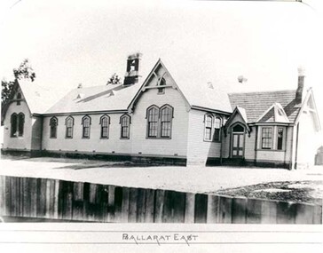
Photograph - Photograph - black and white, Ballarat East State School (No 1071)
The weatherboard Ballarat East State School SS 1071 was formerly known as Specimen Hill. According to 'Visions and Realisations' The Eureka gold lead opened in August 1852, running from Little Bendigo, south beneath Yarrowee Creek into Pennyweight flat, where it was joined 100 yards or so from the intersection of main and Eureka Streets by the Canadian Lead. State School 1071 was formerly known as Ballarat Common School No. 71, and was founded by the Free Presbyterian Church on Specimen Hill in Eureka Street, Ballarat on 01 January 1854. On 20 May 1869 the trustees of the Presbyterian School, Specimen Hill, Ballarat, consented to the transfer of the site to the Board of Education. On 01 September 1870, Specimen Hill, Ballarat, was vested in the Board and then became known as SS 1071. On 01 March 1879 the Minister, The Hon. William Collard Smith, and William Dobbie, Inspector of School Buildings, visited Ballarat to report on the buildings with a view to extensions and renovations. The minister issued instructions for the old wooden part of the school to be demolished, and brick additions to be erected, so that the whole premises would accommodate 350 students. (''Visions and Realisations: A Century of State Education in Victoria, Vol. 2'', Education Department of Victoria, 1973, p 729-730.)Black and white photograph of a weatherboard school with shingle roof known as Ballarat East (SS1071). The building has a brick chimney and bell tower. This school has Castlemaine flagging in the passages.ballarat east state school, education, st paul's school, specimen hill state school -
 Bendigo Historical Society Inc.
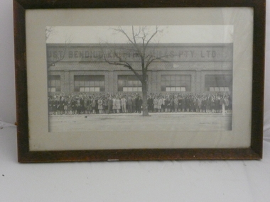
Photograph - BENDIGO WOOLLEN MILLS PHOTOGRAPH, 1940
Framed black and white photograph of large group of people outside large single story building, signage across top of building reads-- ' ? UST Bendigo Knitting Mills. Pty Ltd ' accession Number 531 lists ' Hanro Building 'Bartlet Bros. Bendigo. Handwritten bottom right cornerorganization, business, clothing manafacturer -
 Tatura Irrigation & Wartime Camps Museum
Photograph, Minor Outlet from Waranga Basin, 1957
Taken by photographer for State Rivers and Water Supply Commission.Large, black and white photograph. Large square concrete building set in stone wall, water right foreground, stones left foreground, two men on top of wall left of building, windmill just visible above roof of buildingbelow photo: "Minor outlet from Waranga Basin / Supplies water to parts of West Rodney and Tongala Districts."victoria state rivers and water supply commission, waranga basin, irrigation -
 Surrey Hills Historical Society Collection
Photograph, Laurie Newton (nee Young), Mont Albert Central School, c1956, 1956
Mont Albert State School was officially opened on 23rd April 1917. The school became Mont Albert Central School in 1918, taking in Forms 1 and 2. The school remained a Central School until 1964, when the secondary years formed the basis of a new High School, the Box Hill North High School, later to be named Koonung Secondary College. This is part of a large collection of material related to the Deakin, Mair and Young families, all with connections to Surrey Hills and Mont Albert. Laurie Young was the daughter of Beryl Mair (1916-1976) and Ernest Lance Young (1915-1999). The family lived at 5 York Street and later 11 York Street, Mont Albert. Laurie was born on 18 August 1947. Black and white photo taken of the school building from the path from Barloa Street. There is one large bush to the left of the path obscuring the side of the main building. There is a wooden fire escape at the far end of the building. The grass in the foreground is patchy."School" underlined in blue ink, centre top. "MOnT ALBeRT CENTAL / School" centre in blue biro; thought to be the donor's hand. "GRADE" in blue ink "IV D" in blue ink. "APPROX: 1958" in blue biro; thought to be the donor's hand. These have been written by at least 2 hands and at different times.mont albert central school, laurie young, laurie newton, education -
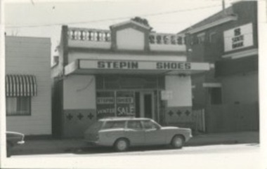 Kilmore Historical Society
Photograph, 25 Sydney Street, 1970's?
14cm x 9cm black and white photograph of the building on 25 Sydney Street. The occupants of the building is 'Stepin Shoes'. It is a light coloured building with decretive trims and written on the window is 'Winter Sale'. There is a station wagon vehicle parked out the front.Written on the back: 25 Sydney St Street Kilmore 25 Syd 011storefronts, shopfronts, retail stores -
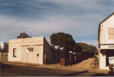 Kilmore Historical Society
Photograph, 83 Sydney Street
15cm x 10cm coloured photograph of the building on 83 Sydney Street. The building is a light coloured building with a corrugated iron facade and angular roofing. On the right of the photograph you can see the previous position of the Goulburn Murray Credit Union. -
 Kew Historical Society Inc
Plan, Melbourne & Metropolitan Board of Works : Borough of Kew : Detail Plan No.1581, 1904
The Melbourne and Metropolitan Board of Works (MMBW) plans were produced from the 1890s to the 1950s. They were crucial to the design and development of Melbourne's sewerage and drainage system. The plans, at a scale of 40 feet to 1 inch (1:480), provide a detailed historical record of Melbourne streetscapes and environmental features. Each plan covers one or two street blocks (roughly six streets), showing details of buildings, including garden layouts and ownership boundaries, and features such as laneways, drains, bridges, parks, municipal boundaries and other prominent landmarks as they existed at the time each plan was produced. (Source: State Library of Victoria)This plan forms part of a large group of MMBW plans and maps that was donated to the Society by the Mr Poulter, City Engineer of the City of Kew in 1989. Within this collection, thirty-five hand-coloured plans, backed with linen, are of statewide significance as they include annotations that provide details of construction materials used in buildings in the first decade of the 20th century as well as additional information about land ownership and usage. The copies in the Public Record Office Victoria and the State Library of Victoria are monochrome versions which do not denote building materials so that the maps in this collection are invaluable and unique tools for researchers and heritage consultants. A number of the plans are not held in the collection of the State Library of Victoria so they have the additional attribute of rarity.Original survey plan, issued by the MMBW to a contractor with responsibility for constructing sewers in the area identified on the plan within the Borough of Kew. The plan was at some stage hand-coloured, possibly by the contractor, but more likely by officers working in the Engineering Department of the Borough and later Town, then City of Kew. The hand-coloured sections of buildings on the plan were used to denote masonry or brick constructions (pink), weatherboard constructions (yellow), and public buildings (grey). The streets and built structures in this plan were surveyed in 1903 and released to contractors in 1904. In addition to the designation of building types by colour, the plan includes detailed descriptions of land use and ownership. While many buildings remain from this period, a number of the buildings represented have been demolished including the original Kew Town Hall, and the Congregational and Roman Catholic churches in Walpole Street. While the mansion ‘Illapa’ in Princess Street is still extant – now part of ‘Rylands’ – the neighbouring mansion ‘Elsmere’ was demolished some decades ago. Rivalling Illapa and Elsmere in size were two mansions in Walpole Street, one named on the plan as ‘Gnarlbine’. Over time, Kew Junction and the south side of High Street have been reconfigured and widened, so that the commercial buildings on the corner of Princess and High Street no longer exist. A surprising feature of this part of central Kew to the northwest of Kew Junction is the amount of vacant land. In a number of cases, this land is noted by the contractor as used for vegetable gardens.melbourne and metropolitan board of works, detail plans, maps - borough of kew, mmbw 1581, cartography -
 Bacchus Marsh & District Historical Society
Photograph, Royal Hotel corner of Main and Young Streets Bacchus Marsh 1883
This image is one of a series of photographs taken by Melbourne based photographers Stevenson and McNicoll who visited Bacchus Marsh nearby districts between September and November 1883. The Royal Hotel was built in 1861 and is located on the corner of Main and Young Streets in Bacchus Marsh. The first owner was James Murray and the hotel was first known as the Murray Family Hotel. James Murray died in an accident in 1863 and sometime after this the ownership passed to Richard Manning. From around 1869 it became known as the Royal Hotel. Richard Manning's son Frederick Manning inherited the hotel in 1896. The Manning family owned the hotel until sometime after 1945. In more recent decades it has been owned and operated by a number of different people. The hotel continues to operate as of 2024. This image shows the building in its original structure. In 1888, five years after this image was taken a second storey was added to the section on Young Street. In this image this section is the single storey section of wall without windows to the right of the picture. Small sepia 'carte de viste' style unframed photograph on card with gold border framing photograph. Housed in the album, 'Photographs of Bacchus Marsh and District in 1883 by Stevenson and McNicoll'. The image shows the Royal Hotel seen from the intersection of Main and Young Streets. The diagonal view shows both the Main Street and Young Street sides of the building. It is a two storey brick building with single storey sections connected to it on both sides. Standing in front of the building on the footpath and facing the camera is a woman and five girls.Printed On the front: Stevenson & McNicoll. Photo. 108 Elizabeth St. Melbourne. COPIES CAN BE OBTAINED AT ANY TIME. On the back: LIGHT & TRUTH inscribed on a banner surmounted by a representation of the rising sun. Copies of this Portrait can be had at any time by sending the Name and Post Office Money Order or Stamps for the amount of order to STEVENSON & McNICOLL LATE BENSON & STEVENSON, Photographers. 108 Elizabeth Street, MELBOURNE. stevenson and mcnicoll 1883 photographs of bacchus marsh and district, hotels bacchus marsh, royal hotel bacchus marsh, manning family bacchus marsh, murray family hotel bacchus marsh -
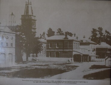 Buninyong Visitor Information Centre
Photograph, Learmonth Street, Buninyong, pre 1930s, Pre 1930
View of Buninyong Fire Brigade, weighbridge, Shire of Buninyong Town Hall, Shops and Buninyong Hotel, pre. 1930s. Brigade building, the weighbridge and the Buninyong hotel were later demolished. Note that the image is incorrectly labelled on the original.Framed two-tone print copy of a photograph. View of Buninyong Fire Brigade, weighbridge, Shire of Buninyong Town Hall, Shops and Buninyong Hotel, pre. 1930s. Brigade building, the weighbridge and the Buninyong hotel were later demolished. Note that the original image is incorrectly labelled.buninyong, buninyong fire brigade, shire of buninyong, learmonth street, weighbridge -
 Federation University Historical Collection
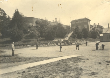
Photograph - Photograph - Black and White, Ballarat Junior Technical School Students Playing Cricket on the Battery Paddock at the Ballarat School of Mines, c1935, 1934
The Battery Paddock ran along Albert Street near the intersection of Grant Street, and was alongside the Ballarat School of Mines battery, or model mine. The Ballarat Junior Technical School was a division of the Ballarat School of Mines. It was established in 1913 at Dana Street Primary School with Albert Steane as Principal. In 1926 a custom built school in the grounds of the Ballarat School of Mines was opened. Today that building houses Prospects Training Restaurant. A number of students of the Ballarat Junior Technical School play cricket on the Battery Paddock of the Ballarat School of Mines. In the background the walls of the gaols are evident, as is the Ballarat Junior Technical School building which was built in 1926.battery paddock, ballarat school of mines, ballarat school of mines battery, ballarat school of mines model mine, ballarat junior technical school, cricket, sport, ballarat gaol, grant street, albert street -
 Federation University Historical Collection
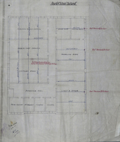
Plan, Ballarat Technical Art School Plan of Proposed Fittings, 1914, 05/03/2014
The Ballarat Technical Art School was a division of the Ballarat School of Mines. A custom built building was opened in 1915. A plan on linen showing the proposed fittings for the new Ballarat Technical Art School Building built in the grounds of the Ballarat School of Mines. The plan has been hand coloured and designates rooms for freehand and plant drawing, model and cast drawing, Modelling Room, Light and Shade Room, Lecture room, Head Master's Office, attendant's office, cloakroom, storeroom, Castings Room, Sheet 7 W.J.G. 5.3.14ballarat technical art school, buildings, ballarat school of mines, plan -
 Mt Dandenong & District Historical Society Inc.
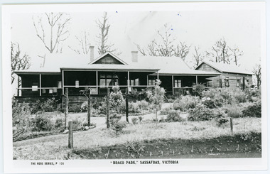
Photograph, Braco Park, c1913
Braco Park Guest House was owned by the aunts of Sir Keith Murdoch, Eliza and Grace. It became a Red Cross convalescent Home for nurses in 1918.It was sold to Mrs. Techow and renamed "Clovelly" in 1920. It had been the Murdoch sisters' guest house, Braco Park, that originally introduced Prime Minister Billy Hughes to the hills. Walter Murdoch's nephew Keith Murdoch, a young parliamentary reporter for the Age, took Hughes and several other politicians up there before the war. Keith's father had been a friend of the previous PM, Andrew Fisher. Keith Murdoch was sent to London as a reporter in 1915, and developed an influential relationship with Hughes who bought a small farm in Sassafras, and ran some of the business of government there during the war and after. Acquired by The Education Department about 1985, the Sherbrooke Community School was built, with the Clovelly house being stripped back to its frame and renovated to form the main building of the school. An existing cottage on the site is also used. B & W postcard showing the front view of Braco Park with another small building to the RHS. Newly planted garden in the front.The Rose Series P. 106. "BRACO PARK" SASSAFRAS, VICTORIA.braco park, clovelly, guest house, murdoch, sherbrooke community school -
 Port Fairy Historical Society Museum and Archives
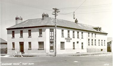
Postcard - Photograph, Seacombe House Port Fairy
Seacombe House Formerly named The Stag Cnr Sackville and Cox Streets Port Fairy John Sanders (Saunders) first came to Port Fairy in charge of the "Sally Ann" owned by the Henty family of Portland. He left the sea behind in 1844 and established the "Sally Ann Inn" named for his old ship, on the site of the present day Star of the West hotel. After selling the Sally Ann Inn to John Taylor he acquired the land on the South west corner of Sackville Street and erected a detached cottage facing Sackville Street for which he obtained a licence to sell alcohol and named the premises The Stag Inn. He died in 1850 and his wife leased the Inn to John Mason. By 1852 a large two story rendered bluestone building had been constructed on the corner site. The second un rendered section was probably added in 1854. Abijah John Brown became licencee in 1855 and made the Stag the centre of entertainment for the district, with many balls, dinners and concerts taking place there. It boasted "a billiard room and a twenty stall stables and coach house". By 1861 Abijah Brown had left The Stag and Lennox Trew was now owner and licencee. It came up for sale in 1869 but failed to sell. After Trew's death in 1886 it was sold to a syndicate and opened as a boarding school. It later became a Coffee Palace and Accomodation house named Seacombe House, and in the 1950's a motel was built on the old stable site. It is still a Hotel Motel and a restaurant which has revived the old name of "The Stag". Black and white Photograph of 2 story rendered building with multi paned windows and power pole on cornerhotel, lennox trew, abijah brown, john sanders, john saunders, john mason., sackville street, cox street, stag inn, stag hotel, seacombe house, coffee palace -
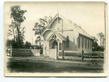 Orbost & District Historical Society
Photograph - black and white photograph
This fine wooden building is located in Browning Street, Orbost and is now (2022) used as the St Andrews Uniting Church Hall. It has a supper room and toilets attached and is a hall that has been used for many community purposes including a Flower Show, exhibitions, concerts, Sunday School, and Harvest Festival etc. In1977, the Orbost Presbyterian Church became the Orbost Uniting Church and the old church became a hall when a new church was built nearby. an excellent photograph of this building which shows the original fence A b/w photograph of a building which is a church with the entrance to the front of the picture. A fence made partly of post and rail, and of white picket in the front of the photo. Some trees in the background. No people can be seen. On back of this photo: 'The first Presbyterian services were held by Rev. Charles Atwood in 1885. He held services in the Mechanics Institute for 5 years. The Presbyterian Church was opened on 9th January 1898. Timber was cut at Richardson's Tabbara mill. Mr R P Cameron built the Church.'presbyterian church, orbost -
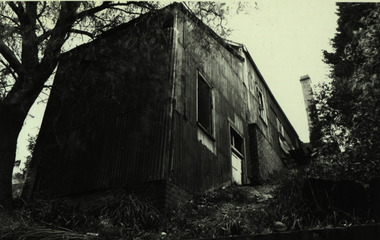 Federation University Historical Collection
Photograph - black and white, Ballarat School of Mines Model Mine, 06/03/1972
These images were supplied by Philip Law in support of capital extimates requests to the state and Commonwealth Governments. Eleven black and white imaes of a number of Ballarat School of Mines Buildings. .1) Former Supreme Court House (Electrical Trades) .3) Pre Fab Building with brick wall .4) Lean to (Possibly added to pottery building as a store and used for pottery hand work in 1972. .5), .6), .9), 10), .11) Corrugated iron buildings - former Model Mine, Albert Street, Ballarat .8) Prefab buildings used for motor mechanicsballarat school of mines model mine, ballarat school of mines mining laboratory, ballarat school of mines mining workshop, albert street, ballarat, former ballarat supreme court, motor mechanics, electrical trades, phil law -
 Bendigo Historical Society Inc.
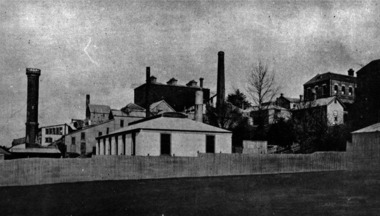
Photograph - S.E.C. VICTORIA, 1940
Photograph - black and white. The new SEC building is surrounded by scaffolding and building workers. The new building is almost complete. Truck backed to the footpath unloading building materials by two men. Light post with three cross bars and street light, ladder leaning on verandah, freestanding ladder, lady in black crossing the street, portion of scaffolding still attached on side of the building. rear of photo has SEC 1940 printed with biro and number 02 written in pencil.organization, public utility, electricity company, s.e.c. victoria. 1940. bendigo. -
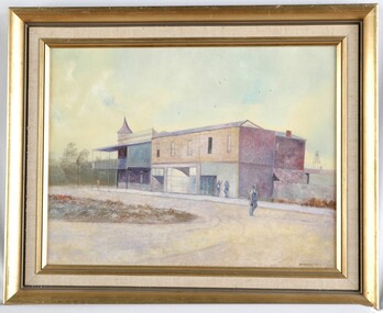 Glenelg Shire Council Cultural Collection
Painting, Down the Street, 1977
UnknownView of a building on a country street. The building is large, and in 3 sections, two of which may be shops. The building on the corner has a verandah and balcony over the footpath, and may be a pub. Two people lean on the wall to the right of the building. One man in overalls and carrying a bag walks along the centre of the dirt road. Framed in gold painted wooden frame.Front: B Malloch '77 (lower left) (brown paint) Back: 1977 - (yellow sticker, upper right) Mer-ger Galleries, Picture Framing sticker, order no. 1057 (sticker, lower centre) "Dow...E Street" (blue pen on sticker, lower left, torn) -
 Surrey Hills Historical Society Collection
Photograph, Surrey Hills Methodist Church in 1918, 1918
The original Methodist (Wesleyan) Church was built on the corner of Alexandra Crescent and Windsor Lane in 1888. It was enlarged in 1892. In 1908 this building was removed to Valonia Avenue by horse-drawn dray. The brick church was built in 1915 after which the earlier building became the Sunday School. In 1977 the Methodist Church joined with others to become the Uniting Church. In more recent times, the brick church has been painted but architectural details visible in this photo can still be discerned.Black and white photo of a brick and rendered building taken from diagonally opposite across Canterbury Road looking to the north-west. The church sits behind a woven-wire fence with an opening at the front and at the side to a portico off Valonia Street. On the RHS is the church hall and on the LHS a small part of the adjacent house can be seen.surrey hills methodist (wesleyan) church, surrey hills uniting church -
Glenelg Shire Council Cultural Collection
Photograph - Photograph - Warrane, Portland, n.d
'Warrane' is a substantial double story residence at 35 – 37 Henty Street and was erected c 1855 for Lindsay Clarke, a local architect and surveyor, Clarke is recorded in the 1857 rate book as the owner /occupier of the premises which it appears to incorporate an earlier single story stone cottage extent on the same site in 1853.The design of the house is centered around eight gables , all identical in size, two on each facade and the street front was originally sheltered by a single story veranda. The stone work in the building is finely executed with dressed stone moldings around all the principal openings. The home is an exceptionally unusual design and is possibly unique in Victoria for its period. The finely executed stone work and overall intactness give added significance.'Warrane' 35 Henty St Portland (now known as 'The Finials'. Also shows building on its western side. Reproduced from small snapshot photo -
Federation University Historical Collection
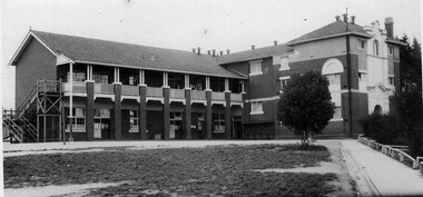
Photograph - Photograph - black and white, Mount Helen Physical Education and Sports Facilities, c1982
Photograph of the Mt Helen Campus, including the library, Union Building. .1 Free standing squash court .2 Roadway from north west entrance .3 Western facade of the Physical Education Building (P Building) .4 and .5 oval .mount helen campus, buildings, physical education, squash court, oval, p building -
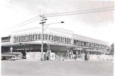
Federation University Historical Collection
Photograph - Photograph - black and white, Construction of the Mount Helen Library and Union Building, 1972, c1982
Photograph of the Mt Helen Campus, including the library, Union Building. .1 Free standing squash court .2 Roadway from north west entrance .3 Western facade of the Physical Education Building (P Building) .4 and .5 oval .mount helen campus, buildings, physical education, squash court, oval, p building -
Glenelg Shire Council Cultural Collection
Negative - Negative - Portland Museum, Victoria, c. 1934
NEGATIVE FOR BLACK AND WHITE PHOTOGRAPH Portland museum east side of Wellington Rd. Wooden building, iron roof, whale bones on verandah and in garden. Woman standing on veranda. Building one of original buildings of hotel where current Gordon Hotel is.negative, portland, gordon hotel, building, construction, museum -
 Halls Gap & Grampians Historical Society
Photograph - Sepia, C June 1930
The Halls Gap store built by Jack Hemley. First Hemley's, then McIntosh's, then Taylor's and now (2010) Ralphy's.Photo shows a building with a Store & Cafe" sign on the roof. Alongside, to the right of the photo, is a petrol station with two pumps and another building next to that. A woman is walking in the centre foreground. The buildings are surrounded by trees and a mountain range can bee seen in the background.buildings, shops -
 Federation University Historical Collection
Photograph - Black and White, Ballarat School of Mines from the north-east corner, c1917
.1) Ballarat School of Mines buildings from Dana Street, near Albert Street, Ballarat showing Caselli's Gauge Tower, Administration Building, and Model Mine. .2) similar view to .1) but showing more foreground and additional buildings, c1917henry richards caselli, gauge tower, ballarat school of mines, dana street, albert street, model mine, mining laboratory -
Port Melbourne Historical & Preservation Society
Photograph - Various buildings, Port Melbourne, Ron Laing, 1990s
Part of Ron Laing's collection of photographs recording Port Melbourne over a thirteen year period. Donated to the PMH&PS by the photographer.A set of 16 colour photographs by Ron Laing covering the Herald and Weekly Times building, the ex Borer's Bakery ovens and buildings, view from Coles parking area, Bridge Street industrial medical clinic and HMAS Lonsdale building 1990sbuilt environment - commercial, built environment - civic, ron laing