Showing 13445 items matching "stations"
-
 Canterbury History Group
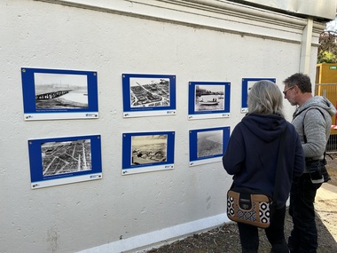
Photograph - Panorama of Canterbury Station
Part two of a set of four sepia photographs which combine to provide a panorama of Canterbury station and its surrounds.canterbury, railway carriages, baptist church, canterbury buildings, canterbury road -
Canterbury History Group
Photograph - Panorama of Canterbury Station
Part four of a set of four sepia photographs which combine to provide a panorama of Canterbury station and its surrounds.canterbury, canterbury station, balwyn road, canterbury road, morton + coghill, duncan + weller, edmonds> frederick. -
Canterbury History Group
Photograph - Building Bradshaws Maling Service Station, 1969
Black and white photograph of construction work on Bradshaws Maling Service Station, from the west looking east, 1969canterbury, maling road, d.h.bradshaw auto service pty ltd, petrol stations, canterbury railway station, theatre place, shops -
Port Melbourne Historical & Preservation Society
Plan - New port workers dining room and alterations, Station Pier, Port Melbourne, Godfrey, Spowers, Hughes, Mewton & Lobb, Feb 1956
Plan new port workers dining room and alterations and additions to existing offices and stores at Station Pier, 1956melbourne harbor trust - port of melbourne authority -
 Clunes Museum
Photograph
COPY OF PHOTOGRAPH OF CLUNES FIRE BRIGADE BUILDING IN HILL STREET, PRIOR TO THE NEW FIRE STATION IN ALLIANCE STREET.local history, photography, photographs, fire brigade -
Lakes Entrance Historical Society
Book, Voices from a Vanishing Australia, 1988
A book of recollections of radio programs 'Word of Mouth', broadcast on Australian Broadcasting Commission radio stations from 1985.broadcasting, communications, archives, bibliography -
Lakes Entrance Historical Society
Book, Mortimer Wallace Malcolm, History of Wonnangatta Station, 1985
The story of Wonnangatta Station in Victoria High Country, and the hardy people who settled and carved a living in the remote area.settlement, agriculture -
University of Melbourne, Burnley Campus Archives
Photograph, John Brown Photography Pty Ltd, Energy Education Centre, Unknown
energy education centre, eec, field station, orchard, school students -
 Lakes Entrance Historical Society
Photograph, 1940 c
Black and white photographs of St Johns church and timber bell tower at the Aboriginal station Lake Tyers Victoriachurches, historic buildings, aboriginal history -
 Port Melbourne Historical & Preservation Society
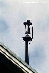
Photograph - Air raid siren in situ, Police Station, Bay Street, 1994
One of two photos of air raid siren in situ on rear of roof of abandoned Police Station, Bay Streetwar - world war ii, built environment - civic -
 Chelsea & District Historical Society Inc
Photograph - Edithvale Fire Brigade, "C" Class Fours, March 1935
This photo was taken at the Fireman's Contest in Ballarat , March 1935. Edithvale won the C Class hose fours. Bill Broothwell (pole), Ron Flanagan (hydrant) Perc Steele (coupling) and Gill Joy (branch)Black and White Photo that has been hand coloured of four members of the Edithvale Fire Station with their fire equipmentfire brigade, contest, fireman, edithvale, chelsea, fire equipment, firefighting, emergency services -
 Port Melbourne Historical & Preservation Society
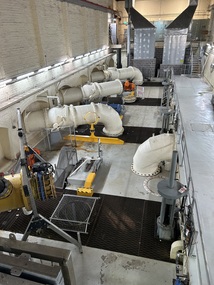
Photograph - Esplanade East Pumpimg Station, David RADCLIFFE, January 2025
Taken at the Esplanade East Pumping Station during the Open Day held by Melbourne Water on the 26th January 2025 engineering - board of works, pumping station -
 Port Melbourne Historical & Preservation Society
Photograph - Esplanade East Pumpimg Station, David RADCLIFFE, January 2025
Taken at the Esplanade East Pumping Station during the Open Day held by Melbourne Water on the 26th January 2025 engineering - board of works, pumping station -
 Port Melbourne Historical & Preservation Society
Photograph - Air raid siren in situ, Police Station, Bay Street, 1994
One of two photos of air raid siren in situ on rear of roof of abandoned Police Station, Bay Streetwar - world war ii, built environment - civic -
 Melbourne Tram Museum
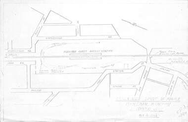
Drawing, Melbourne & Metropolitan Tramways Board (MMTB), "Modal Interchange Huntingdale Railway Station", 1973
Set of four foolscap and folded sheets illustrating model interchange at the Ferntree Gully Railway station to serve Monash University and further west. .1 - Photocopy of a sketch titled "Approximate layout of possible train tram interchange at Ferntree Gully" - dated 16/11/1973 Shows North Road, railway line, railway station and possible tram line. .2 - P14532 - sketch of a schematic layout at Huntingdale showing trains at either platform face along with a tram. Dated 11-12-1973. Has figure 10 along the bottom edge. .3 - P14536 - dated Dec. 1973, showing a possible route to Modal Interchange at Ferntree Gully railway station using Forest Road. .4 - P14537 - ditto, but using Station St. See Reg Item 3806 for sketches at the Huntingdale Railway Station and Monash University.trams, tramways, ferntree gully, new tramway, railways, wellington rd, monash university -
 Wodonga & District Historical Society Inc
Album - Ringer's River by Des Martin - Plate 4 - O'Day's appointment announced
Back at the station MacLough announces to the assembled men that O'Day is now manager of Gooloora, with absolute power to hire, fire, buy, or sell, until he personally decides otherwise. He then has O'Day drive him to Overton where he repeats this to the bank manager, and arranges ample credit for the 20 year old executive before catching his train to the city.The album and images are significant because they document literature written by a prominent member of the Wodonga community. The presentation of this precis was supported by several significant district families and individuals.Ringer's River Album Coloured photo Plate 4 Back at the station MacLough announces to the assembled men that O'Day is now manager of Gooloora, with absolute power to hire, fire, buy, or sell, until he personally decides otherwise. He then has O'Day drive him to Overton where he repeats this to the bank manager, and arranges ample credit for the 20 year old executive before catching his train to the city.des martin, many a mile, ringer's river, northeast victoria stories -
 Bendigo Historical Society Inc.
Book - PASTORAL SETTLEMENT IN NORTHERN VICTORIA - VOL 1. THE COLIBAN DISTRICT, 1979
... stations ...Pastoral Settlement in Northern Victoria, volume 1, the Coliban District. 353 pages with illustrations, photographs and maps.J.O. Randellhistory, agriculture, northern victoria - coliban, farming, agriculture, pastoral settlement, stations, runs -
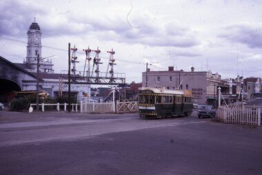 Ballarat Tramway Museum
Slide - 35mm slide/s, Peter Moses, Jan. 1969
Photo of SEC Ballarat No.41 passing through the railway gates at Ballarat Railway Station, Lydiard St. North, with the destination of "Lydiard St Nth". Tram has a SEC "Everything's under control in my all-electric kitchen". Reid's Coffee Palace is in the background. Photo shows the Ballarat Railway Station clock tower, part of the train shed and the signals on the station side of the gates. A "B" class locomotive on a passenger train is standing in platform 1 of the station. Kodak cardboard mount slide, taken by Peter Moses assumed Jan. 1969, dated only "Jan", but date lines up with Bendigo slides and type of numbering. Could be 1970.On the rear of the slides in black ink "P. Moses" along bottom left hand corner in black ink.tramways, trams, railway crossing, lydiard st, railway station, reid's coffee palace, tram 41 -
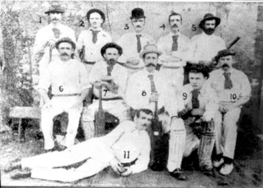 Tatura Irrigation & Wartime Camps Museum
Photograph, Cricket Team c 1889
"Cricket was well established in Tatura by 1880, but it was not until 1889 that the Tatura and District Cricket Club was formed, with Charles Wilson as its first President". Early matches were played at the old Police paddock next to the Station, and later, much hard labour produced "one of the nicest grounds I have ever played on (Rev. C.H. Zercho, 1921), out of the original town rubbish depot at the Public Gardens."Cricket was well established in Tatura by 1880, but it was not until 1889 that the Tatura and District Cricket Club was formed, with Charles Wilson as its first President".|Early matches were played at the old Police paddock next to the Station, and later, much hard labour produced "one of the nicest grounds I have ever played on (Rev. C.H. Zercho, 1921), out of the original town rubbish depot at the Public Gardens.tatura, recreations, sports, games -
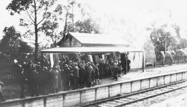 Ringwood and District Historical Society
Photograph, Opening Heathmont Railway Station in May 1926, 1926
Opening Heathmont Railway Station in May 1926. The photo shows the audience, including Bill Everard MLA, at the entrance to the railway platform. The Station building was located on the west side of the tracks, near the corner of Heathmont and Canterbury Roads. At the officially opening, the ribbon was cut by Louise Pump, wife of Herman. -
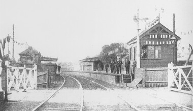 Surrey Hills Historical Society Collection
Photograph, Surrey Hills railway station on Empire Day in 1909
Man in the signal box is believed to be Mr J Rasmussan and the assistant stationmaster, Mr Tom Keating. Published in book 'Surrey Hills in Celebration of its Centenary: 1883-1983', compiled by the History Nook and edited by William Chandler.Black and white photo of Surrey Hills railway station on Empire Day in 1909. Signal box and station are decorated with bunting and lanterns. Gates are closed and there is a man in the signal box. There are approximately 9 men on the platforms including the stationmaster, assistant stationmaster, Mr Tom Keating and other railway officials.transport, empire day, railways, surrey hills station, mr tom keating, mr j rasmussan -
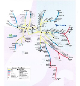 Melbourne Tram Museum
Map, VicTrip, Melbourne rail network - Connex and M>Train, 2000
Map - Colour print - of Melbourne's railway station network, shows the Connex and M>Train areas, zones, V/Line Metcards, Premium stations - used in Fares and Travel Guide - 2000 and 2001 Map - see Reg Item 2508. Also used in poster Reg Item 2514.trams, tramways, connex, map, melbourne, railways, m>tram, connex -
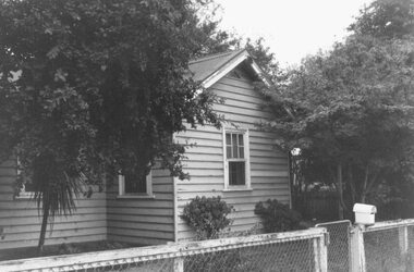 Ringwood and District Historical Society
Photograph, Station hand's house near Wantirna Road bridge, Ringwood. 1986
Black and white photograph (2 images)Written on back of image F0098a: "This is house with external toilet. Station hand's house near viaduct, Wantirna Road. 1986." Written on back of image F0098b: " Wantirna Rd. Outside toilet. Station-hand's house. Near viaduct, 1986." -
 Orbost & District Historical Society
book, Grove, Carl, BUKAN MUNGEE
C.H. Grove spent about 40 years in the area, information is mainly derived from his own recollections and "reliable sources". Charles Henry [Carl] Grove died on 17/4/1938 at Box Hill at the age of 88 and was buried in Orbost. Prior to coming to the Snowy River district, Carl worked as overseer on Buchan Station. In 1880, he selected land at Newmerella after first coming here in 1874 with early selector James A Robertson.He was one of the first selectors at Orbost - in 1880 he selected 320 acres at Newmerella, which he called „Ulinda‟ He married Annie Robertson in 1876. Carl was a farmer, hop and seed grower and nurseryman. He was an elected Councillor of the newly formed Tambo Shire in 1882, and then in 1892 to the Orbost Shire where he served for many years filling varioius public roles. In 1911, he shifted to Queensland, but later returned to Victoria and died at Box Hill. (Ref. Nov 2014 Newsletter) This is a useful reference tool.A carbon copy of a typeset manuscript / transcript book entitled "Bukan Mungee" containing historical and geographical information of the area "bounded by the Snowy River in the east, the Tambo river in the west...and with the following leaseholds, Ensay, Gillingall, and Gelantipy on the north, with Kilmore and Corringle stations on the south..."grove-carl bukan-mungee corringle newmerella snowy-river tambo-river -
 Port Melbourne Historical & Preservation Society
Photograph - Civic structures, Port Melbourne, Ron LAING, Ron Laing, 1986 - 1999
Part of Ron Laing's collection of photographs recording Port Melbourne over a thirteen year period. Donated to the PMH&PS by the photographer.A set of 37 colour photographs of Port Melbourne civic stuctures, 1990s, including the Town Hall, Liardet Community Centre, Freemasons' Hall, RSL Club (Excelsior Hall), old fire station, 1910 Post Office, 1860 Post Office and Naval Drill Hall, Metropolitan Fire Station, Police quarters, Police Station and Court House, Nott Street State School, Graham Street State School, St Joseph's Primary School and Rotunda in Beach Streetbuilt environment - civic, ron laing, nott street state school, graham street state school, port melbourne primary school, port melbourne town hall, liardet community centre, excelsior hall, freemasons hall, fire station, post office, naval drill hall, police station, st josephs catholic primary school, band rotunda -
 Victorian Interpretive Projects Inc.
Photograph - Colour, Clare Gervasoni, Yering Station, 2014, 01/1102014
Yering Station which was first settled by Paul De Castella of Neuchatel, Switzerland. De Castella was a pioneer of Australia's wine industry. The brick building was constructed of handmade bricks around 1859 by Paul De Castella to process grapes grown at Yering Station. De Castella used advanced winemaking equipment imported from Bordeaux, France. Yering Station wines were successful at the World Exhibition in Paris (1889) when it received the only 'Grand Prix' in the Southern Hemisphere. yering, wine, winery, de castella, paul de castella, yering station, neauchatel -
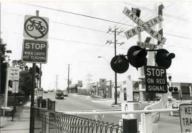 Whitehorse Historical Society Inc.
Photograph, Railway Crossing - Heatherdale Road, 2000
Produced as one of a series of 24 prints commissioned by Nunawading & District Historical Society -|Theme: Intersections of Mitcham and Nunawading 2000/2001.|See also Series by P. Simmenauer on the same theme.Black and white photograph - print and negative of Railway Crossing on Heatherdale Road near Heatherdale railway station looking north towards intersection of Whitehorse and Heatherdale Roads, from L - R Station signage 'The Met/Heatherdale Station (sign to be replaced by new owners Connex - see also No. 3 neg). Note Pedestrian & Cyclists signs; strip shops Hungry Jack's fast food; Dyns LPG Service Garage; ACE Auto Services; bus shelter.railway crossing, heatherdale road, mitcham, connex, 'the met', dyns, ace auto services, hungry jack's fast food outlet -
 Melbourne Tram Museum
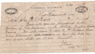
Document - Memorandum, Victorian Railways, Victorian Railways Memorandum, dated 30-11-1906 re St Kilda tramway, 30/11/1906 12:00:00 AM
Victorian Railways Memorandum, dated 30-11-1906 on VR printed form Z 183a, advising Porter (?) G. H. Biquell (?) that he had been transferred to the position of Conductor on the St Kilda Brighton Electric Tramway from 1/12. He was to report to Mr. Bradford at the Power Station, Elsternwick. Signed by J. Keane Acting Station Master West Richmond station. Has been completed using a form with a perforated edge on the left hand side.trams, tramways, victorian railways, st kilda brighton, conductors, personnel, elwood -
 Sunshine and District Historical Society Incorporated
Photograph - Three Old Sunshine Factories, Pratt, Charles Daniel, (1892 - 1968), Photographed circa late 1920's to early 1930's
These three factories clustered together and close to Albion Station provided manufacturing type of employment for several decades. All the factories have now disappeared and have been replaced by retail or service businesses. Spalding has been replaced by a Bunnings Hardware store, while the main retail outlet on the Nettlefolds site is Harvey Norman. Ironically part of the Phoenix Fireworks site is now occupied by the Metropolitan Fire Brigade, as well as other small businesses including a smash repair business, and a tyre retailer.The photograph provides a historical record of some of the types of manufacturing industries that existed in Sunshine, before retail or service industries began to replace them. Many of the younger generation do not know that fireworks, screws, or some sports items were manufactured in Sunshine not so long ago, and where the factories existed.The image depicted in this photographic copy is believed to be from circa late 1920's to early 1930's, and shows the NETTLEFOLDS, SPALDING, and the PHOENIX FIREWORKS factories. These factories were located in North Sunshine on the north side of Ballarat Road near Albion Station. Nettlefolds and Spalding are on the corner of Ballarat Road and McIntyre Road, with Nettlefolds being on the west side of McIntyre Road and Spalding on the east. Phoenix Fireworks factory is composed of small huts, and is situated on the north side of Phoenix Street at the rear of the Spalding factory. The photograph also shows a row of residential houses on Garnet Street which is on the east side of the Phoenix factory. Ballarat Road is still an undivided road and on the south side is a plantation of trees that once stretched from near Albion Station to Anderson Road. Other roads visible are Suffolk Road and Westmoreland Road.Nettlefolds Screw Worksnettlefolds, spalding, phoenix fireworks, screw works, ballarat road, mcintyre road, phoenix street, garnet street, westmoreland road, suffolk road. -
 Flagstaff Hill Maritime Museum and Village
Document - Map, Department of Lands & Survey, Victoria / Panmure, 1942
This Emergency Edition of the map of Panmure, Victoria, is part of the W.R. Angus Collection. It was printed in 1942 during World War II. It is one of two maps donated to Flagstaff Hill Maritime Village by the family of Doctor William Roy Angus, who served as Surgeon Captain in the Australian Defence Department. The map was compiled for the Dept. of Army by the Dept. of Lands and Survey in Melbourne, prepared by the Australian Section of the Imperial General Staff, which was a British Government body created in 1907 to co-ordinate the defence of Britain and its Empire. It was printed by A.H.Q. Cartographic Company, Survey Corps, which was formed in 1941. The Corp changed its name to L.H.Q. Cartographic Company of Bendigo. In 1947 the name reverted back to the A.H.Q. Cartographic Company until 1955 when it became the A.H.Q. Survey Regiment. The W.R. Angus Collection includes historical medical equipment, surgical instruments and material once belonging to Dr Edward Ryan and Dr Thomas Francis Ryan, (both of Nhill, Victoria) as well as Dr Angus’ own belongings. The Collection’s history spans the medical practices of the two Doctors Ryan, from 1885-1926 plus that of Dr Angus who began practice in 1924. Dr. Angus served with the Australian Department of Defence as a Surgeon Captain during the Second World Was from 1942 to 1945. He served in Ballarat, Victoria, and in Bonegilla, N.S.W. until he suffering from a heart attack just before the war ended. ABOUT THE “W.R.ANGUS COLLECTION” - Doctor William Roy Angus M.B., B.S., Adel., 1923, F.R.C.S. Edin.,1928, was generally known as Dr Roy Angus. His working life included a position as a doctor with the Flying Doctor Service in Australia’s rural and remote areas. After many varied experiences Dr Angus and his family moved to Warrnambool in 1939 where he purchased “Birchwood,” the 1852 home and medical practice of Dr John Hunter Henderson. He was appointed on a part-time basis as Port Medical Officer in Warrnambool and held this position until the 1940’s when the government no longer required the service of a Port Medical Officer. Dr Angus was a surgeon at the Warrnambool Base Hospital 1939-1942. After further studies he commenced practice as an ophthalmologist in Warrnambool, pioneering in artificial eye improvements. He was Honorary Consultant Ophthalmologist to Warrnambool Base Hospital for 31 years and made monthly visits to Portland to perform eye surgery. Dr Angus and his wife Gladys were very involved in Warrnambool’s community with a strong interest in civic affairs. They were both involved in the creation of Flagstaff Hill Maritime Village, including the layout of the gardens. After his death on 28th March 1970 his family requested his practitioner’s plate, medical instruments and some personal belongings be displayed in the Port Medical Office surgery at Flagstaff Hill Maritime Village, and be called the “W. R. Angus Collection”. This Emergency Edition of the Map of Panmure is significant as an example of the documents prepared for the defence of Australia in World War 2. The Map is also significant for its connection between the Australian Army and the involvement of Dr WR Angus as a Surgeon in the Medical Services during World War II. The W.R. Angus Collection is significant for still being located at the site it is connected with, Doctor Angus being the last Port Medical Officer in Warrnambool. The collection of medical instruments and other equipment is culturally significant, being an historical example of medicine, administration, household equipment and clothing from late 19th to mid-20th century. Dr Angus assisted Dr Tom Ryan, a pioneer in the use of X-rays and in ocular surgery. The collection includes Dr Angus’s Army objects and is significant as an example of items issued to Doctors and Surgeons in the Medical Services of the Australian Army in World War IIMilitary map of Panmure, Victoria, Australia; part of the W.R. Angus Collection. Rectangular coloured map on cream paper for the Australian Army. Details include sea, waterways and land, contour lines, grid lines, names of districts, towns and roads, bridges, swamps, rail lines, cuttings, tracks, buildings (including blacksmiths), pumps, lighthouses, telegraph, telephones and electric transmission lines, and fire stations. The map has margin notes that include distances in miles to nearby towns. The map was compiled for the Dept. of Army by the Dept. of Lands and Survey in Melbourne, prepared by the Australian Section, Imperial General Staff and printed by A.H.Q. Cartographic Company, Melbourne in 1942. Crown Copyright Reserved. Inscriptions in red print state that it is and Emergency Edition and an Official document. An oval purple stamp includes the price.Printed in black; 'Victoria / Panmure", "No. 930 / Zone 6" Printed in red; “EMERGENCY EDITION”, “THIS MAP IS AN OFFICIAL DOCUMENT. IF FOUND, IT MUST BE HANDED / IN TO THE NEAREST MILITARY HEADQUARTERS OR POLICE STATION” Stamped: within concentric ovals (“- - - FOR SALE / PRICE 2/- / - - - - - OF THE ARMY”)flagstaff hill, warrnambool, flagstaff hill maritime museum, maritime museum, shipwreck coast, flagstaff hill maritime village, great ocean road, dr w r angus, dr ryan, warrnambool base hospital, flying doctor, surgeon captain, australian department of defence, royal australian army, world war 2, map panmure 1942, roy angus, port medical officer, nhill base hospital, military map, emergency map, military service australian army, department of army, department of lands and survey, a.h.q. cartographic company melbourne, panmure 1942, australian section, imperial general staff