Showing 1810 items matching " yarra park"
-
 Emerald Museum & Nobelius Heritage Park
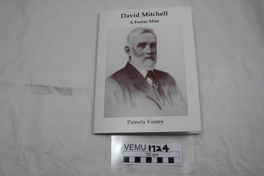
Book, David Mitchell, A Forfar Man by Pamela Vestey, 2014
David Mitchell was born near the town of Forfar, Scotland, became an apprentice to a stone mason and builder, then emigrated to Australia in 1853. In Melbourne, he set up a builder's yard in Burnley St, Richmond and later bought Cave Hill Limestone Quarries in Lilydale and manufactured the cement in Richmond. He became Shire President for Lillydale in 1883. Also he established a brickworks in Burnley St, Richmond. He was responsible for building PLC College in East Melbourne, Menzies Hotel, The Exhibition building and Scots Church. Although he was very wealthy in his own right, he is also known as the father of Dame Nellie Melba. White soft cover booklet with a large drawing of David Mitchell (1901) on the front. -
 Emerald Museum & Nobelius Heritage Park
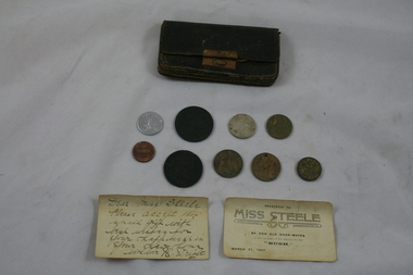
Leather Purse and Coins, About 1907
Leather purse with hand written note to "Mrs. Steele" from "Mrs Wright". Also old coins and tokens insitu. Brass clips. Coins; UK 1943 threepence, 2 X UK 1907 halfpenny (one with hole in it), French 1952 twenty franc, USA one cent, UK 1906 one shilling. Card -presented to Miss Steele by her old shop mates. "Bush" March 27, 1907. Newspaper cutting - in back pocket, T.W. Bull, disease reader and herbalist - advertisement. Card: Presented to Miss Steele, by her old shop-mates on the occasion of her leaving for the "BUSH". March 27, 1907. Card: Dear Miss Steele, Please accept this small gift with best wishes for your happiness in your new home. With love N. Wrightleather purse, coins -
 Emerald Museum & Nobelius Heritage Park
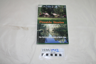
Book, Friends of Kirth Kiln, Fireside Stories, The Parkers as Friends of Kurth Kiln, February 2010
Kith Kiln was the site of a short lived charcoal kiln designed to provide an alternative to petrol during World War 11 when there was a fuel shortage. Local history has been told by Genseric (Bill) Parker and the reflections collected by Friends of Kirth Kiln (under the auspices of Parks Victoria).The booklet is significant because it tells the story of the development of the Kirth Kiln Park in Gembrook, from the Friends perspective.The park is not only historical but is also of great environmental significance and it forms part of community life in the district. Green soft cover booklet of 128 pages. The front cover has 2 photos; the top one of the caretakers compound with Forest Commission huts and the bottom photo is of the Lake, taken from the dam on Tomahawk Creek. The back cover has a diagram of the Kiln logo.Fireside Stories with Genseric (Bill) Parker and Lorna Parker. Reflections collected by Friends of Kirth Kiln.kirth kiln, genseric parker, parks victoria, gembrook, charcoal burner -
 Emerald Museum & Nobelius Heritage Park
Book, On the Trail by Keith Winser, 1956
Caravanning Guide to Australia 1956. Emerald Lake Park is on page 79.Green hard cover, with 240 pages.caravaning, keith winser, 1956, motor manual -
 Emerald Museum & Nobelius Heritage Park
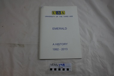
Booklet, University of the Third Age, (U3A), Emerald, A History 1992-2013, 2012 - 2103
The book was written to describe the 21 year history of Emerald U3A from its inception in 1992 until 2013. The third age refers to mature age people, homemakers of retirees aged 55 years and over. And the group offers classes, discussion groups and physical activities, generally from tutors who are members of the group. Memoirs were written by a number of Emerald identities, regarding bushwalking, gardening, language and literature, local history and armchair travel and book discussion. Soft back booklet, white cover.Signed by the author; Brenda E. Webbu3a emerald, brenda e. webb, emerald -
 Emerald Museum & Nobelius Heritage Park
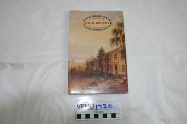
Book, Local History, A Handbook for Enthusiasts by Hibbins, Fahey and Askew, 1985
This book was designed for amateurs to research and write history, particularly local history, It mainly uses Victorian examples, as described in 1985.Soft cover book 149 pages. The cover is beige coloured with a cover illustration of Yarra Street, Geelong 1872.First published in 1985 by George Allen and Unwin Australia Pty Ltdlocal history, hibbens, fahey and askew -
 Emerald Museum & Nobelius Heritage Park
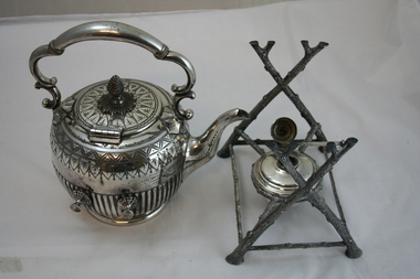
Silver Teapot and Stand
Beautifully decorated silver teapot an silver stand (contains a burner).Engraved: Presented to Oscar and Florrie Nobelius 7/04/1904 on the occasion of their marriage by the Employees of the Gembrook Nurseries Emerald. Refer to VEMUP0843 for photo of Oscar Nobelius.nobelius, oscar and florrie nobelius, silver teapot, gembrook nurseries -
 Emerald Museum & Nobelius Heritage Park
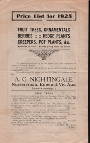
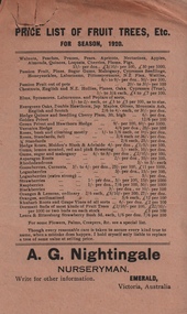
Pamphlet, Price List for 1925, A.G. Nightingale, Nurseryman, Emerald, Vic, About 1925
Nursery owned by Alfred George Nightingale, who originally worked for Nobelius Nurseries. Nightingale Nursery sold fruit and ornamental trees and delivered to Emerald Railway Station. The nurseries covered an area of 50 acres.Part of the horticultural history of Emerald and the surrounding district.Four page, cream coloured pamphlet with black printing. Contains price lists for fruit trees, ornamentals, berries, hedge plants, creepers and pot plants.a.g.nightingale, emerald -
 Emerald Museum & Nobelius Heritage Park
Papers, VEMU1717.1 Price List of Fruit Trees 1920 - A.G. Nightingale;
Part of the horticultural history of Emerald and the surrounding district.VEMU1717.1 Single sheet, buff coloured, printing in black VEMU1717.2 Small sheet of translucent paper, with the text printed in purple with some red text.a.g. nightingale, emerald -
 Emerald Museum & Nobelius Heritage Park
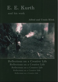
Book, Alfred and Ursula Klink, E.E. Kurth and his work, Reflections on a Creative Life by Alfred and Ursula Kling, 2014
Professor Ernest Edgar Kurth of the University of Tasmania, invented a faster, simpler and cleaner way to produce charcoal on a continuous basis during the second world war. The charcoal was used to produce a combustible gas in motor cars, as a substitute for petrol, which was heavily rationed. The first batch of charcoal was produced in February 1942 and continued until the end of the war. Wood from stringybark trees was cut into lengths and fed into a kiln which converted it into charcoal. The Kiln is located on Beenak Road, 7km north of Gembrook. It has great historical significance, particularly as an alternative supplier of fuel during the second world war. It is a State Registered facility, managed by the Friends of Kirth Kiln and the park is managed by Parks Victoria Green soft covered book of 150 pages, with a photo of 2 men and a boy out in the bush with 3 fires burning.Contains a Prelude about Ernest Edgar Kurth written by Alfred Klink (2013) and a Foreward by John Sullivan (Heritage Officer of Parks Victoria). There is an Acknowledgement page, with recognition given to the grant provided by the Department of Sustainability, Environment, Water, Population and Communities. e.e. kurth, kirth kiln, charcoal kiln, parks victoria -
 Emerald Museum & Nobelius Heritage Park
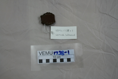
Display Box
VEMU 1738-1 Leather Woggle for holding the scarf around the neck. VEMU 1738-2 Patrol Leader Lanyard. Worn over the left shoulder. VEMU 1738-3 Scout Whistle. VEMU 1738-4 Leather Scout BeltVEMU 1738-1 Woggle, Engraved with scout emblem with words "Boy Scouts". VEMU 1738-3 Whistle, Engraved with "The Emca" Regd. Boy Scouts. VEMU 1738-4 Belt, Buckle with Boy Scout Emblem and inscription "Boy Scouts" and "Be Prepared".scouts, woggle, lanyard, whistle, belt -
 Emerald Museum & Nobelius Heritage Park
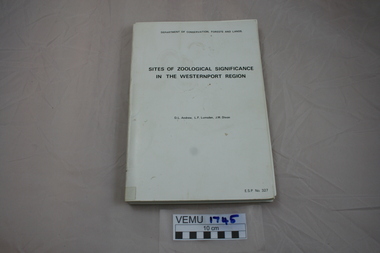
Book, Sites of Zoological Significance in the Westernport Region, 1984
Zoological Significance. The report contains the results of a survey of the vertebrate fauna of the Westernport catchment and a search of relevant literature, conducted between June 1979 and December 1981.White soft cover thick book, about A4 size. Prepared by the national Museum of Victoria for The Environmental Studies Division, Ministry of Conservation, Victoria 1984. -
 Emerald Museum & Nobelius Heritage Park
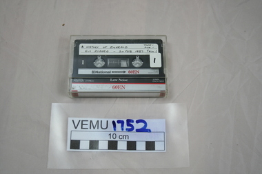
Cassette Tapes, History of Emerald--Gus Ryberg, 1987
-
 Emerald Museum & Nobelius Heritage Park
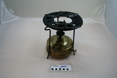
Primus Stove
The stove was the property of John Biggart, who lived in Avonsleigh. He travelled Victoria from 1920 to the 1940's. The stove was used at a work camp site.Brass base containing the kerosene fuel tank, above which rises a burning tube and burner assembly. The steel top rings are held above the burner by 3 support legs. To light the stove, a small amount of alcohol is put into the spirit cup, just below the burner to preheat it. Kerosene was then vaporised, mixed with air and it burns with a soot less, blue flame.PRIMUS No. 1. MADE IN SWEDEN. TRADEMARK PRI-MUS. PATENT SB. No 48624. ENG No 171536, all on the top of the tank. On the side is engraved; A/B B. AHJORTH AND CO. STOCKHOLM SWEDEN - SOLEMAKERS OF THE GENUINE john biggart -
 Emerald Museum & Nobelius Heritage Park
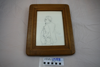
Sketch, "Spud" Dr. Ian S. McLeod Murphy
Dr. Murphy was a popular identity in Emerald and its surrounds. The sketch is significant because it gives a rough image of Dr. Murphy. After he died, a medical scholarship was created in his name for a young, local, first year undergraduate in Medicine. Pencil sketch on cartridge like paper, framed by a wide wooden frame"Spud". Dr Ian S. McLeod Murphy. D. Peterson 1974dr. murphy -
 Emerald Museum & Nobelius Heritage Park
Childrens Tea Set
The tea set belonged to Elaine Nobelius as a child.Bright yellow set of 9 objects: Teapot and lid, milk jug, 2 cups and saucers, 2 bread and butter plates, Sellex No. 72, Regdchildrens tea set, elaine nobelius -
 Melbourne Tram Museum
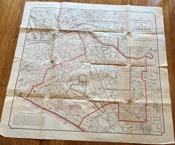
Map, Department of Lands and Survey Melbourne, Commonwealth Electoral Division of Fawkner, 1-10-1912
... Park, Prahran, South Yarra and parts of Melbourne in 1912... Shows a detailed street plan of South Melbourne, Albert Park ...Shows a detailed street plan of South Melbourne, Albert Park, Prahran, South Yarra and parts of Melbourne in 1912. Used to mark the electoral boundaries of the Commonwealth Electoral Division of Fawkner. Shows all the then cable tram lines, rail lines and the electric line of the PMTT along with docks, gardens and significant buildings.Gives details of the Fawkner Electoral district in 1912.Folded sheet - Map - Commonwealth Electoral Division of Fawkner - two colours showing the subdivisions and polling placesmelbourne, fawkner, tram lines, cable trams, maps, electoral maps, south melbourne, albert park, prahran -
 Melbourne Tram Museum
Pamphlet - Metro Tunnel - Anzac Station tram corridor works, Rail Projects Victoria, 11/2022
Provides information about the works planned to realign tram tracks at the Metro Tunnel Anzac station, following the completion of the surface works. Gives timing, tram routes affected, plans of the proposals, contact details. All St Kilda Road routes would be affected from 27/11/2022 to 17/12/2022, tram stops would be closed, bus replacement services. includes works to remove the Glenhuntly Road level crossing at Glenhuntly Station. Yields information about the trackworks for the future Anzac Station interchange and St Kilda Road services.Set of two documents issued by Rail Projects Victoria (Metro Tunnel) and Yarra Trams with regard to the reallignment of tram tracks at Anzac Station Nov. 2022 1 - Metro Tunnel - Works proposed, maps - 6 A4 pages 2 - Yarra Trams - Service Changes St Kilda Road works - 4 A4 pages.anzac station, metro tunnel, tramways, st kilda road, domain road, domain interchange, park street, track work, tram tracks, glenhuntly road, glenhuntly station, level crossings -
 Melbourne Tram Museum
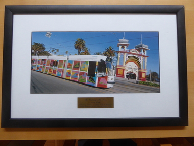
Photograph - framed, Siemens, Centennial tram D2 5006 passing Luna Park, 2006
... tram 5006 Luna Park Siemens Yarra Trams decorated trams ...Framed photo of D2 class tram 5006 passing Luna Park St Kilda, celebrating 100 years of electric trams in Melbourne. See item 864 for the associated pamphlet.Yields information about tram 5006 decorated for the celebration of 100 years of Electric Trams in Melbourne.Framed photo with white window mat, black wood framed and glazed with a gold engraved lable or plaque, with brown paper backing and a wire hanging strip.Engraved lable - "The Centenary Art Tram - Luna Park - Celebrating 100 years of Electric Trams in Melbourne, Proudly sponsored by Yarra Trams & Siemens, 2006"100 years of electric trams, d2 class, tram 5006, luna park, siemens, yarra trams, decorated trams -
 Eltham District Historical Society Inc
Newsletter, Newsletter, No. 20 September 1981
... families of Smiths Gully • Eltham Community Festival • Park name... families of Smiths Gully • Eltham Community Festival • Park name ...Contents: • Next meeting – The Smiths and other pioneer families of Smiths Gully • Eltham Community Festival • Park name assigned • Yarra Glen Historical Society • Diamond Valley News • The Shire of Eltham – a perspective The Shire of Eltham Historical Society was formed in October 1967. The first newsletter of the Society was issued May 1978 and has been published continuously ever since on a bi-monthly basis. With the cessation of the Shire of Eltham in late 1994, the Society's name was revised to Eltham District Historical Society and this name first appeared with issue No. 103, July 1995. The collection of the Society's newsletters provides a valuable resource on the history of the Society's activities, office bearers and committee members, guest speakers and subjects of historical interest pertinent to the former Shire of Eltham and the Eltham District.A4 photocopied newsletter distributed to membersnewsletter, eltham district historical society, shire of eltham historical society -
 Eltham District Historical Society Inc
Audio - Audio Recording, Jim Connor - Eltham Lower Park, 8 Feb. 2023
EDHS Newsletter No. 268 February 2023 Prior to the extension of European people into the lands of the Nillum-bik in the late 1830s the Wurundjeri people had been meeting in the area now known as Eltham Lower Park for thousands of years. Waterway junctions had a particular attraction as tribal meeting places and the junction of the Diamond Creek with the Yarra River (Birr-arung to the Wurundjeri) was one such important location in terms of aboriginal culture. The sculpture “Not Just a Pretty Place” by Aleks Danko, located near the junction of these two watercourses pays tribute to this important cultural location. The first European settlers were squatters or leaseholders and itinerants such as timber workers. Records of their early occupation are sketchy but the Eltham Lower Park area was probably included within the pastoral run established in 1841 by Henry Foley. He sold his leasehold in 1845 to Joseph Wilson who in turn sold it to Frederick Faulkner soon after. From this early history the Eltham Lower Park area has undergone many changes and has been developed to provide residents and visitors with a range of passive and active public open space, including even being used for various horse racing events. At our next meeting, Jim Connor will explore the history of Eltham Lower Park and touch on various individuals and groups involved along the way.1:05:19 duration Digital MP3 file; 22.4MBaudio recording, eltham district historical society, meeting, society meeting, jim connor, eltham, eltham lower park -
 Parks Victoria - Ferntree Gully Kiosk
Equipment - Unknown object
Small object with tapered wooden handle and a metal (smoking) pipe/cup like end. Hollow inside metal section and slightly battered. Wooden handle has black flaking paint. -
University of Melbourne, Burnley Campus Archives
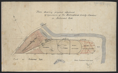
Plan, Plan showing proposed adjustment of boundaries of the Horticultural Society's Gardens in Richmond Park, c.1880-1884
Copy of B92.0535 framed and glazed.gardens, richmond, hoticultural society of victoria, river yarra -
 University of Melbourne, Burnley Campus Archives
Plan, John S. Jenkins, Plan showing proposed adjustment of boundaries of the Horticultural Society's Gardens in Richmond Park, c.1880-1884
Plan on linen fibre cloth. Shows layout of Burnley bound by Swan St., Yarra River and part of Richmond Park, coloured areas showing proposed area to be added to Park, the old road, shrubbery, new hall, old garden, recent extension and proposed further extension (crossed out in red ink). Scale 4 chains:1 inch. Probably drawn by John S. Jenkins, Town Surveyor, Richmond. Has been photographed so that additional copies can be made. On a CD plus 3 negatives, plus small coloured print. (Also copy glazed and framed for Centenary Exhibition - B92.0540.)john s. jenkins, gardens, richmond, hoticultural society of victoria -
 Eltham District Historical Society Inc
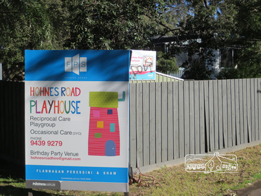
Photograph, Liz Pidgeon, Hohnes Road Playhouse, 1 July 2017
Photo taken as part of an EDHS Heritage Excursion - Saturday 1st July - Eltham Lower Park - Walk and Talk. "Eltham Lower Park has played an important part in the history of our area since the early days of European settlement when it was used by local residents as an informal racecourse. Prior to that its location at the junction of the Diamond Creek and the Yarra River made it an important meeting place for the Wurundjeri people. The park combines formal elements and sporting facilities with remnant bushland that is of environmental significance. It is home to sporting and horse riding clubs, popular play spaces and the Diamond Valley Miniature Railway, which attracts large numbers of visitors.The park will be the venue for our July excursion which will comprise a walk of about 3.5 km around the park and adjacent areas. Along the way we will discuss the history and natural history of the area. The path along the creek and the river provides a pleasant and scenic walk.This walk on Saturday 1st July is about 3.5 km in length and will take 2 to 2.5 hours. It will start at 2pm at the Main Road car park at the front of the park. (Melway ref 21 H 10)". Newsletter No., 234, June 2017 Born Digitalheritage excursion, activities, eltham district historical society, eltham lower park, sign, hohnes road playhouse -
 Melbourne Tram Museum
Film - Compact Diskette with video, Metlink, "Moving a Games City", 2006
DVD, with large format clear plastic cover with paper insert titled "Moving a Games City", sub-titled "A look at public transport during the Melbourne 2006 Commonwealth Games". Produced by Metlink, running time 17mins, has the games logo, Metlink., Yarra Trams, Connex, BusVic, VLine and Victorian Government logos on the rear. Features various elements of public transport access during the games, how they coped made changes, planning, Richmond station, Flinders St station, use of buses, passenger flows at Richmond, opening event, Ballarat station, VLine services, Doncaster Park and Ride and buses, Southbank depot, depot run outs, the Yarra Trams Fleet operations centre, Aquatic centre tram stops, St Kilda station, Southern Cross station, a very short segment of Z81, information campaigns, Metlink call centre, Rob Barnett of VLine, Dennis Cliche of Yarra trams, Peter Gibson of VLine, Digby Drew of Yarra Trams, John Stanley of BusVic, Mark Whitehead of VLine, Bernie Carolan of Metlink, Scott Martin of Dept. of Infrastructure, VLine, Mary Dimovski of Metlink, Andrew Kyriacou of Connex, Bruce Hughes of Connex.trams, tramways, commonwealth games, yarra trams, passenger services, metlink, connex, vline -
 Eltham District Historical Society Inc
Photograph - Digital Photograph, Alan King, Downing-Le Gallienne house, Yarra Braes Road, Eltham, 30 January 2008
The property is a classic example of what made Eltham famous from the late 1940s to the 1960s. Covered under Heritage Overlay, Nillumbik Planning Scheme. Published: Nillumbik Now and Then / Marguerite Marshall 2008; photographs Alan King with Marguerite Marshall.; p149 The first view of the large double-storey house at Yarra Braes Road, Eltham South, is of a jutting roofline over a balcony, reminiscent of a large sailing vessel or galleon – very appropriate, considering the name of one of the first owners, Le Gallienne. The Downing-Le Gallienne property is a classic example of what made Eltham famous from the late 1940s to the 1960s and attracted so many artists and intellectuals to the area. Set in a largely indigenous bush-style garden, the mud-brick and timber house was built by Alistair Knox. It was built for economist Richard Downing, to become a founder of the welfare state in Australia and Chairman of the Australian Broadcasting Commission, and musician and composer Dorian Le Gallienne. Le Gallienne was a pioneering composer of modern music in Victoria before 1945, whose works included the Symphony in E.1 He wrote several pieces of film music for Eltham Films, including The Prize, working with its writer and artistic director Tim Burstall. Le Gallienne was also a music critic for The Argus and later for The Age. In 1967 the music critic Roger Covell argued that Le Gallienne’s Symphony, was ‘still the most accomplished and purposive . . . written by an Australian’. According to Alan Marshall the main inspiration behind the building that evolved from 1948 to 1964 was Le Gallienne. ‘He was able to see value in the simplest things and many who worked there had their eyes opened for the first time to the Eltham environment, to the bush and the trees and the fauna which lived there.’ The garden included no formality, no lawns, nor exotic plants. ‘Natural informal growth came right up to their doors and so did the indigenous birdlife.’ This informal style – consisting of mass and void – was to be developed and popularised by landscaper Gordon Ford from the 1950s. The large mud-brick and timber house, which was built in four stages and has three separate but linked sections, began as a small weekend retreat for the couple. In 1948, Downing and Le Gallienne (Dick and Dor to their friends), asked Knox to build the 36 x18 foot (11mx5.4m) building with a pitched slate roof. It was built on a concrete slab and included a fireplace, which is still in use. The second wing was built in 1954 after Downing had returned from working at the International Labour Office and the couple decided to live there full-time. The third section was built after the death of Le Gallienne in 1963, aged 48. He is buried in the Eltham Cemetery. When Downing married widow, Jean Norman (nee McGregor) and had to accommodate a large family, including her six children and one of their own, the last stage was built by 1964. At that time the house was considered one of the largest mud-brick houses in Victoria. It consists of five living areas, including a small ballroom. Several artists helped Knox build the Downing-Le Gallienne house, which was one of his first of mud-brick. They included painter Clifton Pugh, artist John Howley and actor Wynn Roberts. Ellis Stones had landscaped the first wing and Gordon Ford set the boulder steps and made a pool as part of the landscaping he completed. Inside, the mud-bricks are largely whitewashed with pine-lined ceilings and Oregon beams. A winding timber staircase in the front extends behind a glass window from the ground floor to the top. The property, of a little more than 0.5 ha, is bordered by Parks Victoria land, which extends to the Yarra River.This collection of almost 130 photos about places and people within the Shire of Nillumbik, an urban and rural municipality in Melbourne's north, contributes to an understanding of the history of the Shire. Published in 2008 immediately prior to the Black Saturday bushfires of February 7, 2009, it documents sites that were impacted, and in some cases destroyed by the fires. It includes photographs taken especially for the publication, creating a unique time capsule representing the Shire in the early 21st century. It remains the most recent comprehenesive publication devoted to the Shire's history connecting local residents to the past. nillumbik now and then (marshall-king) collection, dorian le gallienne, downing-le gallienne house, eltham, mudbrick construction, mudbrick houses, richard downing, yarra braes road -
 Eltham District Historical Society Inc
Photograph - Digital Photograph, Alan King, Diamond Creek, Barak Bushlands, Eltham, 2008
A habitat corridor and it strengthens the community. Published: Nillumbik Now and Then / Marguerite Marshall 2008; photographs Alan King with Marguerite Marshall.; p185 Barak Bushlands lie west of the Diamond Creek on the corner of Falkiner Street and busy, noisy Main Road. They form part of an important habitat corridor linking the Yarra River to the Kinglake National Park.1 Manna Gums, tawny frogmouths and platypuses are some of the indigenous plants and animals that have made their home there. The bushlands are the result of more than nine years of hard work by the local community with the Nillumbik Council, to transform a degraded flood plain into this refuge of natural beauty. In 1997, shortly after moving into the new Riverside Estate on Falkiner Street, Eltham, several residents noticed the sorry state of the Diamond Creek and surrounding area. Part of it was used as a cow paddock and although small patches of vegetation survived, the area was infested with weeds, rabbits, rubbish and drainage from the housing estate. At various times the 4.4 hectares had been used as a market garden and for shire stock piles. The residents began to restore the area by revegetating land along the Diamond Creek. In 1998 they established the Friends of the Diamond Creek Falkiner Street Reserve2 and 35 families joined from the 90-house Estate. Carolyn Mellor, as the Friends’ Land Manager, undertook a four-year horticulture course to guide this massive project for a volunteer organisation. Since 1999, she has been the Friends’ President. In 1999 the Friends urged the Nillumbik Council to undertake a feasibility study into establishing a wetland system and urban forest. Work began in 2002 with Nillumbik Council funding the project, supplemented by government grants. The Friends also received grants from Melbourne Water and Parks Victoria. Aided by the Friends and other community members, the Council created the Barak Bushlands consisting of a forest, a wetland, a bridge, a path and open space. The beautiful wetland treats most of the estate’s stormwater runoff. Storm water is filtered through plants in the wetland ponds then is released slowly into the billabong, before flowing into the Diamond Creek. The wetland also helps to minimise flooding and the improved water quality provides a flora and fauna habitat. The Friends and other volunteers planted more than 27,000 plants, more than one third of which they grew from seeds they collected at Lower Eltham and Wingrove Parks. Eltham High School students planted thousands of these through a Year Eight program introduced for this purpose. Other groups who assisted were: Green Corps, local Scouts and Guides – 2nd Montmorency, 1st Diamond Creek and 1st Eltham Cub Packs, Eltham College students, Eltham East Primary School, Landcare members, Eltham Lions Club and the Eltham Baptist Church. To maintain enthusiasm for the mammoth task, the Friends and other volunteers ‘adopted’ trees to water and wrote their names on the stakes. In 2004, to recognise the area’s original occupiers, the reserve was named Barak Bushlands. William Barak, who lived from 1824 to 1903, was the last chief of the Yarra Yarra tribe of the Wurundjeri-willam people. Traces of these original inhabitants remain in scar trees (bark sections removed to make a shield or canoe). That same year the Friends’ group was a finalist in the prestigious Federal Government, Banksia Environmental Awards. The Friends have also participated in Clean Up Australia, removing tonnes of rubbish and regularly testing the billabong, wetland and creek, for pollutants. For years the Friends, together with the Australian Platypus Conservancy, have tagged, measured and checked the health of platypuses from the Diamond and Mullum Mullum Creeks. With Latrobe University the Friends have conducted night walks to view owls, possums, bats and sugar gliders. Challenges for the council and the Friends continue with a large rabbit population, some vandalism, weed eradication and maintenance. However, thanks to this community effort, locals can now escape confined urban living on small blocks of land and enjoy the beauty of indigenous plants and animals. Working together has also strengthened the local community,This collection of almost 130 photos about places and people within the Shire of Nillumbik, an urban and rural municipality in Melbourne's north, contributes to an understanding of the history of the Shire. Published in 2008 immediately prior to the Black Saturday bushfires of February 7, 2009, it documents sites that were impacted, and in some cases destroyed by the fires. It includes photographs taken especially for the publication, creating a unique time capsule representing the Shire in the early 21st century. It remains the most recent comprehenesive publication devoted to the Shire's history connecting local residents to the past. nillumbik now and then (marshall-king) collection, barak bushlands, diamond creek (creek), eltham -
![Painting: Park Street [Adeney Avenue] Kew](/media/collectors/550653872162f11fb04854aa/items/5826877cd0cdd11284ad5413/item-media/614ac683a53a0756fd5e49da/item-fit-380x285.jpg) Kew Historical Society Inc
Kew Historical Society IncPainting, Park Street [Adeney Avenue] Kew, c. 1896
‘Adeney Avenue’ was the title given to this painting following its donation to the Kew Historical Society, yet the work’s origins predate the naming of Adeney Avenue in 1907 [originally gazetted as ‘Park Street’ (1865) and ‘Park Street South’ (1875).] Park Street ran between High Street and Parkhill Road beside what was later to become ‘Victoria Park’. This area was described in 1851 as “…a dense forest of gums and wattles which were to be largely cleared by 1888 after the naming of a recreation reserve”. The Reserve was still bisected by an unnamed creek in 1896, when the area was surveyed by the MMBW. The panoramic vista selected by the artist would appear to include ‘Eborensis’ (c.1895) on the corner of Parkhill Road and what was then Park Street, with views across cleared land towards the distant ranges. In the 19th century, north Kew was largely undeveloped farms stretching down to the Yarra. Oil on canvas by an unidentified artist of a panoramic view depicting what is now known as East Kew with mountains on the horizon. In the foreground is a two storey brick residence - Eborensis - located on the northeast corner of Parkhill Road and what is now Adeney Avenue. The view of the landscape and its rolling hills resulted from farming practices adopted following colonisation and settlement. Trees in the foreground and in the distance include remnant Eucalypts and introduced exotics.Label on rear of frame states "House on corner of Adeney Ave & Parkhill. [Regd. 254"]. Otherwise unsigned and undatedadeney avenue (kew), eborensis, park street (kew) -
 Kew Historical Society Inc
Work on paper - Sepia Wash & Ink, G B Richardson, Creek and Old Watering Stage, on the Yarra, East Collingwood, 1854, 1854
Blind Creek was located between the Abbotsford Convent and what is now the Collins Bridge in Studley Park. In an 1858 map of East Collingwood by Clement Hodgkinson, in the State Library of Victoria, one can see how the creek was originally a significant landmark in Collingwood; remaining vacant land until a barrel drain enclosed it. The area was later filled in, surveyed and developed. The position where Blind Creek entered the Yarra was in the immediate vicinity of Hodgson’s Punt, which had linked Kew to the other side of the Yarra from 1839. The Punt was purchased by the Colonial Government in 1852 and was in use until the opening of the Studley Park Road (Johnston Street) Bridge in 1858 made its continued use redundantThe point of view selected by the artist for the watercolour is from the banks of Blind Creek in East Collingwood, looking across the Yarra to the Kew side of the river.Inscribed verso 'Creek and Old Watering stage, on the Yarra East Collingwood 1854 / Trees, stage, &c have long since disappeared / [Artist Signature] / FT 110 / Creek itself now being filled in 1903.gb richardson, blind creek - abbotsford, yarra river - abbotsford (vic) - kew (vic), colonial artists, australian art - 19th century, george bouchier richardson