Showing 176572 items
matching streets
-
 Bendigo Historical Society Inc.
Document - MCCOLL, RANKIN AND STANISTREET COLLECTION: NELL GWYNNE SYNCLINE
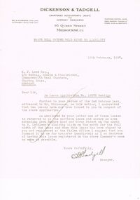
Manilla folder of documents relating to the Nell Gwynne Syncline Mining lease. Mentioned are Lease No.'s 10875 and 10903 which is in the Empire Road Stray Street area; R. Lethlean's Sluicing Claim; Albert Selisky has permissive Occupancy on ¼ acre; New Chum Syncline; Liddell's Chenical and Metallurgical Works; Arum Dredging Development NL. Application for a Hydraulic Sluicing Lease; Transfer of lease No. 10903, from H.J. Leed to North Nell Gwynne Gold Mines NL; Application form for the Nell Gwynne Syncline Co.. Application for leases 10945 and 10946; Nell Gwynne Syncline option to purchase lease 10945 for £1,000; Consent from Minna Matilda Lawson for inclusion of part of allotment 268 in lease No. 10875.Dickson & Tadgell Charted Accountants, 95 Queen Street, Melbourne C1gold, mining, land application, nell gwymme syncline, gold mines, bendigo -
 Ararat & District Historical Society (operating the Langi Morgala Museum)
Photograph
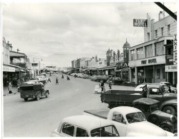
The photograph is taken from the balcony of Leopolds Hotel, as favoured by many photographers. This photograph features Barkly Street in Ararat during a busy day of business and commercial activity. The vehicles in this photograph enable an estimated date circa 1950's and the pedestrian traffic state of dress in the image suggest it was taken in the cooler months.Langi Morgala museum holds a succession of photos taken from this same vantage point, which allows a comparison of the main street of Ararat over 100 to 150 years. The growth and decline of businesses and perhaps government buildings can also be ascertained. Because of this comparison value, this photo is of regional significance.Black and white photograph of Barkly Street, Ararat. Notable feature is the Turf Hotel to right of image.barkly street, ararat, turf hotel, 1950s -
 Tatura Irrigation & Wartime Camps Museum
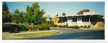
Photograph, Stuart Mock Place, Hogan Street, Tatura
Shows picture of Stuart Mock Place at the intersection of Francis and Hogan Streets, Tatura. Also old State Bank and real estate buildings.Colour photograph showing Stuart Mock Place at the intersection of Francis and Hogan Streets, Tatura. Photograph stuck onto piece of white cardboard. hogan street tatura, francis street tatura, stuart mock place tatura, state bank tatura -
 Eltham District Historical Society Inc
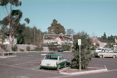
Slide, Pryor Street carpark, Eltham, 25 Jul 1973
... streets ...View through the Pryor Street carpark which ran between Luck and Pryor streets. The original Safeway supermarket is visible in the background off Pryor Street. Cars in the immediate vicinity are a Morris 100, and HD/HR Holden wagon and an HQ Holden35 mm colour positive transparency Mount - Agfacolor Service (Blue)eltham, pryor street, carparks, hd holden, hq holden, morris 1100, safeway supermarket, shopping centre, streets, hr holden, luck street -
 Victorian Interpretive Projects Inc.
Photograph - Colour, Clare Gervasoni, St Alipius Presbytery, Ballarat East, 07/01/2012
St Alipius Church was the first Catholic Church at Ballarat. It was initially a tent church in Humffray Street, but after flooding it was moved to Victoria Street were the current bluestone church was built. The presbytery is beside the church and houses the priests. A colour photograph in digital format showing red brick building with slate roof, behind a green iron fence. The building is St Alipius Presbytery, Victoria Street, Ballarat East. ballarat east, catholic, religion, church, st alipius', st alipius -
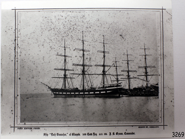 Flagstaff Hill Maritime Museum and Village
Photograph - Vessel - Sailing Ship, Fred. Kruger, Loch Vennachar of Glasgow, 1875-1888
This is a photographic image of the three-masted iron clipper Loch Vennachar created by photographer Fred Kruger of Geelong. Fred Kruger was born in Germany in 1831 and migrated to Victoria before his wife, who arrived in 1863. He began working in photography in the 1850s. He was internationally recognised for his work, which covered a variety of subjects. He settled in Geelong in later years, registering his studio in Skene St, Newtown. He passed away in February 1888. The National Gallery of Victoria now holds much of his work. Loch Vennachar: - Loch Vennachar made many journeys from Britain to Australia and was well-known in Australian ports. On one of its homeward-bound journeys from Australia, the ship sank in the River Thames. Its cargo included 850 tonnes of preserved canned rabbits from Warrnambool's Western Meat Preserving Company. The ship was raised and continued trading for another four years. On 14th June 1905, Loch Vennachar departed Glasgow for Adelaide and Melbourne. The last known sighting of it was on 6th September 1875 when overtaken by the SS Yongala; the captains exchanged the “all well” signals. After that, the ship disappeared with loss of all 27 lives, according to a list that was received by Fremantle through the English mail. The list indicated that there were no passengers on that voyage. Sadly, other Loch Line ships med with similar disasters. The list of lost crew on the Loch Vennachar included Thomas. W. Pearce, apprentice, Southampton. His father was Tom Pearce, one of the two survivors of the Loch Ard, wrecked in 1878. Also, Thomas’ grandfather, James Pearce, was the captain of SS Gothenburg at the time of her wrecking in 1875. Consequently, the wrecking of the Loch Vennachar and the Loc Sloy near the southwest point of Kangaroo Island, a lighthouse was erected, officially opening in June 1907. The northern headland of West Bay was named Vennachar Point in memory of the ship in 1908. The wreck was discovered in 1976 by divers from the Society for Underwater Historical Research, over seventy years after being lost off Kangaroo Island.The Loch Vennachar performed a significant role in Australia’s colonial trade, taking goods between Great Britain and Australia. These goods included locally preserved tinned rabbits processed at a factory in Warrnambool for overseas trade.Black and white photograph of the Loch Vennachar at the dock, without sails. (aka Loch Vennacher). Printed below photo "Loch Vennachar of Glasgow, 1485 Tons Reg. AA1 100. T.S. Ozanne, Comander" and "Fred Kruger Photo / Skene Street, Geelong" Printed below photo "Loch Vennachar of Glasgow, 1485 Tons Reg. AA1 100. T.S. Ozanne, Comander" and "Fred Kruger Photo / Skene Street, Geelong" flagstaff hill, warrnambool, shipwrecked-coast, flagstaff-hill, flagstaff-hill-maritime-museum, maritime-museum, shipwreck-coast, flagstaff-hill-maritime-village, loch vennachar, loch vennacher, loch line ship, glasgow shipping co, 1875 clipper ship, loch vennachar image., kangaroo island shipwreck, 1905 shipwreck, fred kruger photographer, photograph loch vennachar, preserved rabbits, canned rabbits, meat preserving company, western meat preserving company, 1901, 1905 -
 Sunbury Family History and Heritage Society Inc.
Photograph, c 1920s
The 'Meeise' French car is parked outside the former Mechanics Institute Hall in Stawell Street, Sunbury. J Eadie was responsible for the building of the hall in 1885 and the foundation stone was laid by Lady Janet Clarke. The former Shire of Bulla conducted their council meetings in the hall from 1923 until 1956 when new offices were built in Macedon Street. Later the RSL took over occupancy of the hall and it became known as the Memorial Hall. In the early 1970s Stawell Street was cut off to traffic and incorporated into the Village Green.Over the years the Memorial Hall has been the venue for many community events from debutant balls, flower shows, local gatherings, celebrations and markets to name a few.A sepia photograph with a cream border of a tree lined street with a building in the foreground and a vintage car parked outside the building. Tall pine trees are growing behind the fenceline.mechanics institute, shire of bulla -
 Ringwood and District Historical Society
Flyer, Land Sale Brochure, Heathmont Estate, Vic. - circa 1960
Advertisement for sale of residential lots - Heathmont Estate, opposite Heathmont Railway Station, with map and locality plan.Subdivision includes Canterbury Road, Royal Avenue, Coleman Street, Stoda Street, Herman Street, and Campbell Street. Agent - A.W. Dickson, opposite Station, Ringwood. Phone WU6007. -
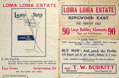 Ringwood and District Historical Society
Flyer, Land Sale Brochure, Loma Loma Estate, Ringwood East, Vic. - circa 1924
Flyer includes extract from "The Sun" 30/10/1924. "Ringwood has been created a Borough with capital value of £680,000. In 1908 there were 173 houses, 8 shops and 720 people. In 1918 the respective figures were 520, 45 and 2,080. For twelve months ended June, 1924, £51,000 worth of Home Sites were sold and £26,000 worth of new buildings were erected. Outward (train) passenger journeys have increased from 94,000 in 1919 to 182,000 in 1923. Train services have been almost doubled and time to Melbourne reduced from 60 to 37 minutes."Bi-fold double-sided land sale advertisement for Loma Loma Estate, Ringwood East, including area map, layout of the estate, and summary of local facilities and services.Subdivision includes Loma Street, Highton Street, Morinda Street, and Station Street (later Railway Avenue) Ringwood East. Agent: T.W. Burkitt, Ringwood, Phone Ringwood 157. -
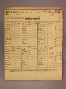 Ringwood and District Historical Society
Administrative record - Rate Books, Borough of Ringwood Valuation & Rate Cards for 1944-49 (Assessments 3193-3197), March 2012
Originally stored at Ringwood Council offices, then taken to PROV.Only source of ratepayers in the Borough of RingwoodDigital imagesFor BR Stewart (Belgrave Road), Violet Sampson (Barkly Street), Margaret Cowin (Barkly Street), Edith Phillips (Barkly Street) & Arthur George (Barkly Street, Allman's Estate). -
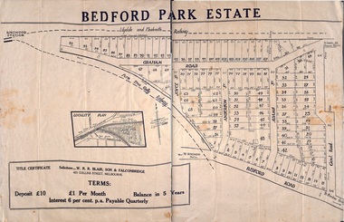 Ringwood and District Historical Society
Plan - Sub-division, Bedford Park Estate, Ringwood, Victoria - 1924
Bedford Park subdivisional development did not eventuate. The land adjoining the railway line became parkland with provision for sporting facilities and the remainder was purchased by the Education Department as the site for Ringwood High School/Secondary College. Poster size land sale advertisement.Subdivision plan includes Bedford Road, Graham Road, Joyce Street, Anderson Street, and Adams Street. Solicitors - W.R.R. Blair, Son & Falconbridge, 405 Collins Street, Melbourne. -
 Kew Historical Society Inc
Plan, Melbourne & Metropolitan Board of Works : Borough of Kew : Detail Plan No.1571, 1904
The Melbourne and Metropolitan Board of Works (MMBW) plans were produced from the 1890s to the 1950s. They were crucial to the design and development of Melbourne's sewerage and drainage system. The plans, at a scale of 40 feet to 1 inch (1:480), provide a detailed historical record of Melbourne streetscapes and environmental features. Each plan covers one or two street blocks (roughly six streets), showing details of buildings, including garden layouts and ownership boundaries, and features such as laneways, drains, bridges, parks, municipal boundaries and other prominent landmarks as they existed at the time each plan was produced. (Source: State Library of Victoria)This plan forms part of a large group of MMBW plans and maps that was donated to the Society by the Mr Poulter, City Engineer of the City of Kew in 1989. Within this collection, thirty-five hand-coloured plans, backed with linen, are of statewide significance as they include annotations that provide details of construction materials used in buildings in the first decade of the 20th century as well as additional information about land ownership and usage. The copies in the Public Record Office Victoria and the State Library of Victoria are monochrome versions which do not denote building materials so that the maps in this collection are invaluable and unique tools for researchers and heritage consultants. A number of the plans are not held in the collection of the State Library of Victoria so they have the additional attribute of rarity.Original survey plan, issued by the MMBW to a contractor with responsibility for constructing sewers in the area identified on the plan within the Borough of Kew. The plan was at some stage hand-coloured, possibly by the contractor, but more likely by officers working in the Engineering Department of the Borough and later Town, then City of Kew. The hand-coloured sections of buildings on the plan were used to denote masonry or brick constructions (pink), weatherboard constructions (yellow), and public buildings (grey). This plan is the other half of Plan No.1571 representing the constructions to the west of Wellington Street before and in 1903/4. This plan represents the built environment in Edgevale Road, Wellington Street, Atkins Street, Annadale Street, Mortimer Street, and Cotham Road. Whereas there are smaller allotments and more modest housing stock facing Edgevale Road, larger blocks and more substantial houses are represented facing Cotham Road.melbourne and metropolitan board of works, detail plans, mmbw 1571, cartography -
 Port Melbourne Historical & Preservation Society
Photograph - Miss Congue's Costumier Shop, Bay Street, Port Melbourne, c. 1900
This laser print is a copy of a photo which has been in the Congues/McKenzie family collection since early this century. Mrs Marie Vernon of Doncaster showed the photo to her cousin, Elva Mason, also of Doncaster but formerly of 35 Cruikshank Street. Elva had the copy done and passed it on to Barbara Gardiner. Mrs Vernon was unable to give us much information but could tell us that her mother, Mrs Mary Jane Congues (known as Ruby) was a tailoress who started her apprecticeship at age 13 and later established the shop which was next to Earl's hardware shop. We think that she was born in the 1880s. The Congues family lived at 36 Cruikshank Street, and their landlord in later years was Mr Sullivan, who supplied horse and drays for rubbish collection for the Council. Simon McKenzie was the loca policeman who patrolled up and down Bay Street and became interested in Ruby. She later visited a fortune teller who told her she would marry a man with numbers on his hat. They married and lived in Brunswick East, Carrum Downs and later Calligee (near Traralgon). LIfe was tough but Mrs Vernon remembers that her talented mother was able to teransform garments and hats so that her daughters always felt that they had a new dress for each special occasion. Mrs Vernon also remembers when a member of the famly needed dental care, they wee put on the train to stay with Grandma at Port Melbourne, who took them to Frost the Dentist (on the corner of Graham and Bay Strees), who pulled teeth for one shilling each. Miss Gongues is the lady in skirt and blouse on the right; other people unknown.Laserprint of four women in entrance to Miss Congue's Costumier shop in Bay Streetbusiness and traders - tailors and clothing, mary jane (ruby) congues, mary jane (ruby) mckenzie, simon mckenzie, mr sullivan, frost the dentist -
 Mission to Seafarers Victoria
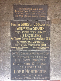
Photograph - Digital photograph, Geraldine Brault, 6 August 2019
The bottom stone was the foundation stone for the main building laid Tuesday 5 February 1907, and the middle stone was the foundation stone for the chapel, laid Tuesday 1 December 1908. The two stones were inserted on the wall of the current Mission building probably when the Siddeley Street institute was demolished. The stones are located in the courtyard on the wall of the former chaplain's office. next to the chapel.The stones are the few remnants of the first Central Institute.Photograph depicting the two foundation stones of the former Seamen's Institute located on Siddeley Street.siddeley street institute, reverend a. gurney-goldsmith, sir thomas david gibson carmichael (1859–1926), governor of victoria, lord henry stafford northcote (1846–1911), governor general of australia, flinders street mission, australian wharf -
 Melbourne Tram Museum
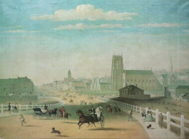
Artwork, other - Swanston Street from Princes Bridge c1861
Colour print of Reproduction of an oil painting - Swanston Street from Princes Bridge c1861 showing Johnson's Bridge Hotel, later Young and Jacksons, the first St Paul's church building, original Town Hall building and the tower of Scots church. Shows pedestrians and horse drawn carriages before the introduction of public omnibus services in 1869. Not known who produced the card.Yields information about early Melbourne after the start of the gold rush.Reproduction of an oil painting - Swanston Street from Princes Bridge c1861 by Henry BurnIn ink on the rear Keith Kings stamp and the initials RG and "Melbourne"melbourne, princes bridge, horse drawn vehicles, st pauls cathedral, hotels -
 National Wool Museum
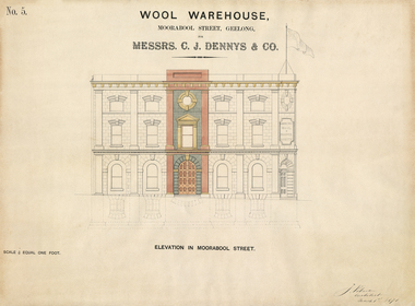
Architectural Plan, Wool Warehouse, Moorabool St, Geelong for Messrs C.J. Dennys & Co., Plan Elevation in Moorabool Street
Original Jacob Pitman architectural plan of the Dennys Lascelles bluestone woolstore dated 1 March 1871. Titled "Wool Warehouse, Moorabool St, Geelong for Messrs C.J. Dennys & Co., Plan Elevation in Moorabool Street".Wool Warehouse, Moorabool St, Geelong for Messrs C.J. Dennys & Co., Plan Elevation in Moorabool Streetwool stores, pitman, mr jacob, dennys lascelles wool store -
 Phillip Island and District Historical Society Inc.
Booklet, Cowes McRae Beach Estate, 1960s
This land was owned by the McRae family, whose wife was a Justice. Hence the street names of McRae and Justice. The weatherboard family home [ originally a guest house called Glen Isle] was at the end of the current Justice Road. The estate was created in the mid 1960s. The house was put on skids and dragged by two tractors and a bulldozer to 364 Church Street while the family home was built at 368 Church Street, Cowes.[ Source Sandra Rocotas, nee McCrae. Facebook Community Noticeboard 5/2/2023. Permission given to use information and photos ] Estate was sold by Rogan Real Estate.HistoricalColoured A4 brochure describing the McRae Beach Estate, including plan of streets and location on Island, photos and description of the Island. Sold by Rogan Real Estate.Cowes McRae Beach Estate - Right in the heart of things .Phillip Island - The Loveliest Isle on Earthhousing, justice family, mcrae family, glen isle guesthouse, cowes west, rogan real estate cowes phillip island -
Port Melbourne Historical & Preservation Society
Document, F. R. Tonkin, History of S.S. No. 1427, Nott St. Port Melbourne, 31 Mar 1969
The writer, F R TONKIN , has written a brief history of the Nott Street State School from its opening on 1st July 1874 to the end of March 1969. Due to falling enrolments the school closed in 1992 with the Port Phillip Specialist School relocating there in 1996.Two A4 typed sheets of information relating the history of Nott Street School until July 1969.1.7.1874 Nott St School Built Cost 5375.0.0 education - primary schools, state school 1427 nott street, f r tonkin -
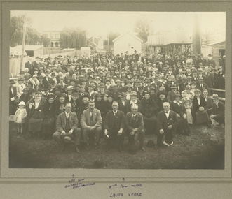 Clunes Museum
Photograph, 1920
CROWD SCENE BACK TO CLUNES 1920. NOVEMBER 13TH. 1920 NAMES OF PEOPLE IN THE PHOTOGRAPH HAND PRINTED IN INK, PHOTOGRAPH TAKEN ON VACANT BLOCK (COLLINS PLACE) IN FRASER STREET, .1 REPRODUCTION BLACK AND WHITE PHOTOGRAPH OF CROWD TAKEN DURING BACK TO CLUNES 1920. TAKEN ON VACANT BLOCK [ COLLINS PLACE] IN FRASER STREET, CLUNES .2 ORIGINAL BLACK AND WHITE PHOTOGRAPH OF CROWD TAKEN DURING BACK TO CLUNES 1920. TAKEN ON VACANT BLOCK [ COLLINS PLACE] IN FRASER STREET, CLUNES.1 On Front; Handwritten in black ink, Back to Clunes 1920, J F Weickhardt, Phil Rowe, J Strangard, J Flower On Reverse; stamped in faded black in Shire of Talbot & Clunes .2 On Front; 3RD. ROW ELIZABETH NIGHTINGALE 2ND. MIDDLE LAURA VEALE Stamped with Rialto Ballarat On Reverse; Handwritten in black ink "Back to Clunes Nov 13th to 20th 1920photographs, events and celebrations, back to clunes -
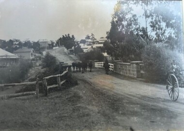 Greensborough Historical Society
Photograph - Photograph (Framed), Herding stock over blue stone bridge looking up Main Street Greensborough
Heading stock over Blue stone bridge looking up Main Street Greensborough. In this photograph, Greensborough was a country town. Note the unmade road leading up to the bridge.From the John Mackey collection. This item was displayed at the offices of Ryan, Mackey and Kelly, solicitors, Main Street Greensborough.Timber-framed photograph of herding stock over blue stone bridge looking up Main Street Greensborough, black and white.greensborough, john mackey, blue stone bridge, marble hall -
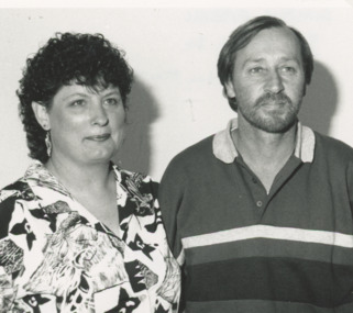 Lakes Entrance Regional Historical Society (operating as Lakes Entrance History Centre & Museum)
Photograph, Lakes Post Newspaper, 1/03/1993 12:00:00 AM
Also black and white photograph of Simply Fabric shop front 1 56 Church Street Lakes Entrance number 03760.1 size 6 x 7 cmBlack and white photograph of Lynne and Peter Marshall proprietors of Simply Fabric 1 56 Church Street Lakes Entrance Victoriabusinesses -
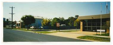 Tatura Irrigation & Wartime Camps Museum
Photograph, Tatura Fire Station
Shows picture of the former site of Tatura Fire Brigade, Casey Street, Tatura. The station was opened in 1972 and closed in 2021 when a new one was built. Building to left is premises of F L and A T Forster & Sons, 68 Casey Street, Tatura. Formally part of the Tatura Flour Mill.Colour photograph showing the old Fire Station in Casey Street, Tatura. Also shows premises of Forster & Sons. Photograph stuck onto piece of white cardboard. tatura fire station, f l & a t forster, tatura flour mill, casey street tatura -
 Kew Historical Society Inc
Plan - Subdivision Plan, Thornton Estate, 1918
The ‘Thornton Estate’ was the final subdivision of ‘Thornton’ in Studley Park Road. Thomas Cubitt Balmain originally owned Thornton, next to John Carson’s ‘Clutha’. Before its final subdivision, the Thomson family owned it. The Estate was a subdivision of 15 residential allotments running between Studley Park Road and Stevenson Street. The allotments faced these streets as well as Thornton Street, which the vendor undertook to make. Contemporary newspaper advertisements advised that ‘The estate possesses many advantages, notably its private and secluded, though convenient, position, splendid frontages and depths, and being close to the electric tram and Kew train, also within easy walking distance of the Victoria-street cable tram’. The terms offered purchasers were ten per cent deposit, with the balance to be paid in ten equal half-yearly payments at a rate of 5 per cent.The ‘Thornton Estate’ was the final subdivision of ‘Thornton’ in Studley Park Road. Thomas Cubitt Balmain originally owned Thornton, next to John Carson’s ‘Clutha’. Before its final subdivision, the Thomson family owned it. The Estate was a subdivision of 15 residential allotments running between Studley Park Road and Stevenson Street. The allotments faced these streets as well as Thornton Street, which the vendor undertook to make. Contemporary newspaper advertisements advised that ‘The estate possesses many advantages, notably its private and secluded, though convenient, position, splendid frontages and depths, and being close to the electric tram and Kew train, also within easy walking distance of the Victoria-street cable tram’. The terms offered purchasers were ten per cent deposit, with the balance to be paid in ten equal half-yearly payments at a rate of 5 per cent.subdivision plans - kew, thornton estate, studley park road -- kew (vic.), thornton avenue -- kew (vic.), stevenson street -- kew (vic.) -
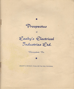 Warrnambool and District Historical Society Inc.
Document, Prospectus (Leahy’s Electrical), 1951
This is the 1951 prospectus of the new company known as Leahy’s Electrical Industries Limited and formed from the previous business of Jim Leahy, Electrical Engineer. The business was then and remains today at 82 Fairy Street, Warrnambool . The business of Jim Leahy had been operated in conjunction with Leahy’s Hire Cars and commenced in 1946. This was initially a good business with 25 employees but the building stock and plant were destroyed by fire in 1950 with the business continuing on a limited scale until the new company in 1951 was formed. Jim Leahy purchased the freehold at the corner of Liebig and Koroit Streets and the business prospered from there but today it is based back in Fairy StreetThis prospectus is of some significance as it signals the start of the important business in Warrnambool today of Leahy’s Electrical. The prospectus shows that the original directors were Leahy, Dwyer, Walter, Croft, White and Affleck and they were prominent Warrnambool and district people at that time. This prospectus also has a good summary of the history of the Leahy business up to 1951 and the financial statements etc are of considerable importance to researchers and other readers. This is a typed prospectus of six pages printed back to back and with a buff-coloured cover of lightweight card. The printing on the cover is dark blue. Front Cover: ‘Prospectus of Leahy’s Electrical Industries Ltd, Warrnambool, Vic, Collett & Munday, Printers, 254 Timor Street, Warrnamboolleahy’s electrical, jim leahy, leahy's electrical prospectus, warrnambool -
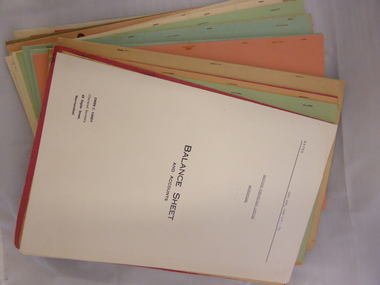 Warrnambool and District Historical Society Inc.
Box, Swintons, Box – early 20th century
This box contains a label from the Warrnambool business of W. Swinton & Sons and this tells us that the box dates from the early 20th century (pre 1912). The documents in the box are Swinton financial balance sheets from 1928 to 1970 (W. Swinton & Sons/Swintons Pty Ltd). William and Ann Swinton migrated to Australia in 1854 and for a decade William Swinton worked as a builder and carpenter in the Warrnambool area, erecting many buildings, including the Wangoom Presbyterian Church. In 1865 he opened a store in Timor Street Warrnambool, selling groceries, glassware, china and hardware. By 1888 the business was known as William Swinton and Sons. Branch stores were opened in Cudgee, Nullawarre, Wangoom, West Warrnambool and South Warrnambool. After William Swinton died his son Robert became the first managing director of Swintons Pty Ltd. In 1934 the business split, with George Swinton and Sons selling clothing, furnishings and glassware and Swintons Pty Ltd selling seeds, produce and hardware. Today the Swinton family still operates a furniture and bedding store in Timor Street. Both these items come from the Warrnambool business of W. Swinton & Son/Swintons Pty Ltd and both the box with its early 20th century label and the financial statements are of importance. The balance sheets will be useful to researchers. The current Swinton business in Timor Street is the oldest family business in Warrnambool and, with the name Swinton associated with Timor Street businesses for 152 years, it is amongst the oldest family businesses in Australia. .1 This is a black cardboard box with a lid, with one side of the lid party detached. Some parts of the box are torn, especially the corners of the lid. The inside of the box is somewhat stained. The inside of the lid has a label pasted on and the top of the lid has a W. Swinton & Sons label pasted on. The Swintons label is partly torn away. .2 The paper material inside the box is mostly foolscap-size and consists of business financial balance statements. Some of these have coloured paper covers. ‘W Swinton & Sons Universal Produce Buyers and Exporters Timor Street Warrnambool’ swinton family, warrnambool, history of warrnambool -
Port Melbourne Historical & Preservation Society
Document - Photocopy, maps, 1890s maps, 30 April 1890 .01 11 March 1890 .02
.01 Copy of Map 3084B - Port Melbourne, Willamstown Road to Esplanade East; to Graham Street; to Boundary Road & Pickles Street. .02 Copy of map of Port Melbourne, Bay Street to Clark Street; to Foreshore; to Pickle Street & Spring Street..01 for title information see parcels index 47,53,54,55,56 & 57. .02 Parcels index 3084-B 16 (City of Port Melbourne)built environment - commercial, built environment - domestic, city of port melbourne, parish of south melbourne -
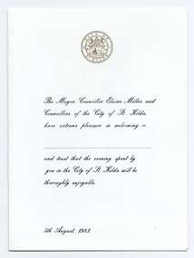 St Kilda Historical Society
Ephemera - Menu, Civic Dinner, 1984
Menu for a civic dinner hosted by the City of St Kilda (Mayor Elaine Miller) on 5 August 1983. The menu is written in French and the illustration inside is of 'Royal Street in the Old New Orleans French Quarter'. Folded white card printed in black with a gold St Kilda crest on the front and an illustration of a street in New Orleans inside.city of st kilda, civic dinners, st kilda mayor elaine miller -
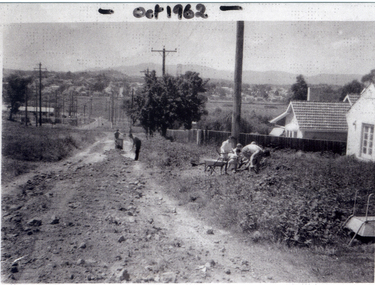 Whitehorse Historical Society Inc.
Photograph, Good Governs Street, Mitcham, 1962
People maintaining Good Governs Street are Arthur Roberts, John Kift, Cliff Bellamy and Doug Sawyer.Black and white photograph of people maintaining Good Governs Street, Mitcham, which is unmade. Two figures working on the road and a group near a pole on the right.good governs street, mitcham -
 Ringwood and District Historical Society
Flyer, Land Sale Auction Brochure, East Ringwood Station Estate - 1924
Bi-folded double sided sheet with yellow and blue print advertising auction of retail and residential allotments on Saturday, 29 March (1924), including details of subdivision features and local facilities. Subdivision includes Station Street, Wenwood Street, Lois Street, Victoria Street. Auctioneer - Tudehope & Coppard, 229 Collins Street, Melbourne, Tel. Central 2409, in conjunction with local agent, T.A. Burkeitt, Ringwood, Tel. Ringwood 157. -
 Port Melbourne Historical & Preservation Society
Photograph - Boys on bike Graham Street, Port Melbourne, c.1950
Ahe boy at the top of three on the bike pyramid is Jim SINCLAIR. Under him is Li CLEARIHAN, and seated on the bike itself, Ted McMILLAN (?). The photo taken in front of a brick cottage in Graham Street, Port Melbourne. Part of a sign for McAlpine flour can be seen on a building in the background.Sepia photograph of' three boys apparently on one bike in front of a cottage in Graham Street,Port Melbourne.On reverse: Jim Sinclair, Li Clearihan, Ted McMillan Graham St Port Melbgraham street, jim sinclair, ted mcmillan, mcalpine flour, li clearihan