Showing 438 items matching " brick home"
-
 Marysville & District Historical Society
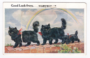
Postcard (item) - Novelty postcard, Valentine Publishing Co. Pty. Ltd, Good Luck from MARYSVILLE, 1940's -1960's
A novelty postcard with pull-out strip of 9 miniature photographs that was produced by the Valentine Publishing Co as a souvenir of Marysville.A novelty postcard with pull-out strip of 9 miniature photographs that was produced by the Valentine Publishing Co as a souvenir of Marysville.Good Luck from MARYSVILLE 1782 PRINTED PAPER MAILING NOVELTY TO OPEN RAISE FLAP From VALENTINE'S "MAIL NOVELTY" POST CARD COPYRIGHT Printed in Great Britain To "Kooringa"/ Sunday Dear Heather. JUST A LINE FROM MARYSVILLE/ TO LET YOU KNOW WE ARE OK AFTER OUR/ TRIP UP. LEFT HOME AT 8-30 THIS MORNING,/ AND AFTER LUNCH AT HEALESVILLE ARRIVED/ HERE AT 1-30. IT CERTAINLY MAKES A/ DIFFERENCE HAVING THE CAR. YOU DO/ ENJOY THE TRIP. WE HAVE A NICE BIG/ ROOM SO SHOULD BE QUITE HAPPY./ LOTS OF LOVE FROM AUNTY AND UNCLE XXXXmarysville, victoria, postcard, souvenir, valentine publishing co, crossways cabaret (image 1), taggerty river (image 2), acheron way (image 3), blacks spur (image 4), nicholl's lookout (image 5), main street marysville (image 6), sugarloaf bay eildon (image 7), steavenson falls (image 8), cumberland falls (image 9) -
 Eltham District Historical Society Inc
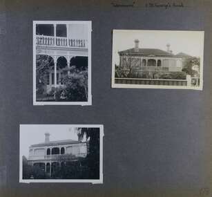
Folder, 2 Metery Road, Eltham South
... of bellbirds engulf this Alistair Knox home of special ambience... of bellbirds engulf this Alistair Knox home of special ambience ...Morrison Kleeman Real Estate sales information material for the Alistair Knox designed house known as the Zull House. "Nestled into a private hill of more than an acre of established gardens, shady ornamental gardens, shady ornamental grapesvines and gumtrees, sounds of bellbirds engulf this Alistair Knox home of special ambience. This home features the textures and colours of nature, home made Hawthorn bricks, flooirng slate from the old St Kilda baths and recycled timbers..." The property was sold Feb 26, 2004 (Source: realestateview.com.au) Knox was a pioneer in the use of mudbricks and recycled materials and is significant to his contribution of this style of architecture in Eltham and the wider Shire of Nillumbik.1 documents, 2 pages A4 gayle blackwood collection, houses, morrison kleeman real estate, metery road, eltham south, alistair knox, zull, st kilda baths -
 Glen Eira Historical Society
Album - Album page, Bureel (Kooyong Road), Circa 1972
This photograph is part of the Caulfield Historical Album 1972. This album was created in approximately 1972 as part of a project by the Caulfield Historical Society to assist in identifying buildings worthy of preservation. The album is related to a Survey the Caulfield Historical Society developed in collaboration with the National Trust of Australia (Victoria) and Caulfield City Council to identify historic buildings within the City of Caulfield that warranted the protection of a National Trust Classification. Principal photographer thought to be Trevor Hart, member of Caulfield Historical Society. Most photographs were taken between 1966-1972 with a small number of photographs being older and from unknown sources. All photographs are black and white except where stated, with 386 photographs over 198 pages. From: Glen Eira Heritage Management Plan 1996 by Andrew Ward In 1856, John Allee, a builder from Brighton, purchased C.A. 37 on the south-west corner of Glenhuntly and Kooyong Roads. The land comprised just over 45 acres. By 1863, Francis John Sidney Stephen, a lawyer and cousin of J. Wilberforce Stephen, owned most of lot 37. By 1866, Stephen had a built a "small mansion" named ''Burreel". It was a brick house and Stephen lived there until 1882. By 1884, Mrs Buxton of Hillside Terrace, East Melbourne, had purchased the property. Richard Buxton, a gentleman was listed as occupant and the house described as "brick, eight rooms". NAV was £300. Richard Buxton continued residency in 1887 however in 1888, George Allen, music seller, became occupant. At that time the house had thirteen rooms on twenty-three acres of land. Twelve people lived there and NAV was £920. In 1900, Daniel Luxton, stock and sharebroker and the Honourable John Taverner, M.H.A. leased the property. Fourteen people lived there. Mrs Buxton continued as owner. By 1910, ownership had passed to Mrs Mary Neate, who converted the house to a nursing home. The land had been subdivided by 1913 and sold by ''Buxtons Estate". Burreel Avenue, Baxter, Buxton and Hoddle Streets were created. "Burreel" was rated to Burreel Avenue and stood on lot 13 with frontages to Burreel Avenue and Kooyong Road of 198' and 214'. The house had ten rooms. NAV was £60. Mary Neate, a nurse, continued as owner/ operator of ''Burreel" nursing home in 1927. At that time there were sixteen rooms and fourteen residents. NAV was £100. Mrs Neat remained there until 1947. In 1948, the house was turned into apartments. In the 1980's, the Alexander family purchased it and restored it to a private residence.Burreel 331 Kooyong Road, ELSTERNWICK VIC 3185 - Property No B4950 National Trust https://vhd.heritagecouncil.vic.gov.au/places/65648 This is a large and substantially intact example of the grand villas of nineteenth century Melbourne. The bulk of the house most probably was built in 1866-1868 for Francis John Sidney Stephen, a prominent and highly regarded Melbourne solicitor and a member of an illustrious legal family. Stephen conducted a lucrative private practice and in 1845 was appointed first solicitor to the City of Melbourne; a position he held until his death in 1895. He took an active part in the development of Caulfield and was Shire President in 1874 and 1877. He was a resident at Burreel from 1868 to 1882. The house has evolved in stages, the rear wings possibly remaining from a house built during the 1850s. The existing ornate cast iron verandah was probably built between 1882 and 1888 during the residence of Richard Buckhurst Buxted, a notable boom period auctioneer and real estate agent. George Allan, the founder of Allan's music store, was another important occupier from 1888 to 1991. Bureel's essentially residential quality has been retained and the interior has been well preserved. The significance of this building does not rest in any single unusual outstanding architectural feature, or in its association with a particularly prominent member of society in the past, but rather in the consistent integrity of both the interior and exterior, which results in the survival of an outstanding example of this type of residential building and its associations with two notable citizens. Classified:11/08/1990Page 113 of photograph album with 1 photograph of Burreel in its garden.Handwritten: Bureel [top left] / 113 [bottom left]trevor hart, caulfield, caulfield north, kooyong road, thomas king, mansion, 1860's, bureel, burreel, francis john sidney stephen, city of melbourne, shire president, 1850's, verandah, nursing home, john allee, ornamented corner stones, new orleans manner, plaster rendered, mrs luxton, vincent willis, alexander family, victorian architectural style, ornate cast iron work, lawyers, brick houses, richard buxton, richard buckhurst buxton, george allen, george leavis allan, allans music, daniel luxton, john taverner, mary neate, buxtons estate, land subdivision, mary neat, gardens -
 Glen Eira Historical Society
Album - Album page, Neerim Road, Circa 1972
This photograph is part of the Caulfield Historical Album 1972. This album was created in approximately 1972 as part of a project by the Caulfield Historical Society to assist in identifying buildings worthy of preservation. The album is related to a Survey the Caulfield Historical Society developed in collaboration with the National Trust of Australia (Victoria) and Caulfield City Council to identify historic buildings within the City of Caulfield that warranted the protection of a National Trust Classification. Principal photographer thought to be Trevor Hart, member of Caulfield Historical Society. Most photographs were taken between 1966-1972 with a small number of photographs being older and from unknown sources. All photographs are black and white except where stated, with 386 photographs over 198 pages. "Edenkillie" was the home of Frederick Jowett, Caulfield's shire secretary and town clerk from 1887 to 1921. The Outer Circle Railway's Oakleigh section opened 1890 and closed 1895. Victorian Heritage database (as of 26/10/2021) HO45 Edenkillie https://vhd.heritagecouncil.vic.gov.au/places/35545 "Edenkillie" at 37 Neerim Road, Glenhuntly, is a substantial two storeyed polychrome brick villa, built for Frederick Jowett, municipal secretary, in 1890. It has aesthetic, historical and social significance. "Edenkillie's" aesthetic value derives from its survival as a substantially intact example of a common villa form expressed in polychrome brickwork. Its historical significance lies in its association with Frederick Jowett, Shire of Caulfield secretary and town clerk for over three decades. Its social significance is derived from the building's ability to demonstrate the kind of lifestyle which a local government administrator could enjoy during the Land Boom.Page 145 of Photograph Album with four landscape photographs from Neerim Road: two photographs of No 37 and two of the Outer Circle Railway Reserve.Handwritten: Neerim Road [top left] / 37 NEERIM ROAD 1OCT 1972 [under top left photo] / 37 NEERIM RD 1 OCT 1972 [under top right photo] / OUTER CIRCLE RAILWAY RESERVE MURRUMBEENA [under bottom left photo] / 145 [bottom left]trevor hart, neerim road, murrumbeena, caulfield, edenkillie, glen huntly, polychrome brick, mansions, frederick jowett, town clerks, shire of caulfield, outer circle railway, railways, parks and reserves, outer circle railway reserve, cast iron work, verandahs, balconies -
 Glen Eira Historical Society
Album - Album page, Glenmoore, St George's Road, Circa 1972
This photograph is part of the Caulfield Historical Album 1972. This album was created in approximately 1972 as part of a project by the Caulfield Historical Society to assist in identifying buildings worthy of preservation. The album is related to a Survey the Caulfield Historical Society developed in collaboration with the National Trust of Australia (Victoria) and Caulfield City Council to identify historic buildings within the City of Caulfield that warranted the protection of a National Trust Classification. Principal photographer thought to be Trevor Hart, member of Caulfield Historical Society. Most photographs were taken between 1966-1972 with a small number of photographs being older and from unknown sources. All photographs are black and white except where stated, with 386 photographs over 198 pages. From Victorian Heritage Database citation for HO59 Glenmoore, 1 St Georges Road Elsternwick https://vhd.heritagecouncil.vic.gov.au/places/35202 as at 30/10/2020 "Glenmoore" is locally significant as a surviving mid nineteenth century villa residence in the then fashionable bi-chromatic brick form. It is also important as the home of Hugh Moore who built several shops in nearby Glen Huntly Road and which remain as important contributors to the architectural character of the Elsternwick Shopping Centre.Victorian Heritage Database citation HO59 Glenmoore, 1 St Georges Road Elsternwick https://vhd.heritagecouncil.vic.gov.au/places/35202 An imposing two storeyed villa in bichrome brick with two storeyed timber posted verandah, coupled with cast iron lace frieze, spandrels and central tympanum enrichment. The hipped roof is in slate and has a prominent crean1 brick chimney stack forming part of the facade. Openings are flat arched although the entrance is round arched with a fan light. The south elevation has bayed windows. Two storeyed hip roofed additions are sympathetic and attached on the north side and at the rear. Inside, the staircase and stained glasswork with initials "HM" and family coat of arms are important surviving elements. INTEGRITY: Good, timber outbuildings of an early date, mature and spacious front garden includes early palm trees. Alterations include reconstruction of facade verandah including tiled pavement and front door on east side. Interior has a high level of integrity. Original grounds included adjoining "Carramar".Page 178 of Photograph Album with three photographs of Glenmoore, St Georges Road. Handwritten: "Glenmoore" 1 St George's Road [top right] / 178 [bottom right]trevor hart, chimneys, porch, mansion, slate roof, return verandah, stained glass, cast iron frieze, glenmoore, 1860's, hugh moore, glenmoore estate, double storey, elsternwick shops, st george's road, thomas watts, elsternwick, victorian style, protruding bay windows, cast iron work, bi-chromatic bricks, gardens, balconies, moore's buildings, glen huntly road, stairs, house names -
 Glen Eira Historical Society
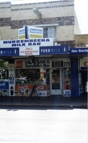
Photograph, Murrumbeena Road, 229, Murrumbeena, 2001
Originally labelled "Beauville Estate, Established 1936, Still Thriving 65 years on, 10th March 2001", the Beauville Estate Album contains colour photographs of houses in the Estate. They were taken around the time of the Beauville Estate’s 65th Heritage Celebration held on 10/03/2001 and donated to the Caulfield Historical Society shortly afterwards. Photographer unknown. From Glen Eira’s Heritage Management Plan by Andrew Ward (1996) Vol 2 p78: In Murrumbeena Road, the shops which form part of the estate are a simple cream brick row relieved by manganese bricks in bands across the upper storeys. City of Glen Eira’s Heritage Management Plan Vol 2 p79 (this is p84 of the pdf version) – HO12 Beauville Estate and environs, Murrumbeena: The Beauville Historic Area is important at the State level as the first large housing estate undertaken by the AV Jennings Construction Co, later Jennings Group Limited, Victoria’s largest home builder. It is important also as a very early estate development incorporating a range of features other than houses and including made roads, shops and recreation facilities. In this respect it was the forerunner of the comprehensively planned housing estate of the post war era. The estate is distinguished by its aesthetic values, as is the earlier and comparable Hillcrest Estate, which are formed by a combination of restrained diversity in house styles, with the exception of no. 30 in the emerging International style, and by a landscaped garden environment. Colour photograph of a section of a double storey, unpainted brick, commercial property containing shops at ground level all with awnings over the footpath. This specific property is a milk bar on street level with plate glass windows and door, colourful advertising and "229' in the top right section of the window. Shop signage says "MURREMBEENA MILK BAR". The upper storey brick residence features a large window, a flat roof and decorative two tone banded brickwork. MURREMBEENA (sic) MILK BAR / PK's / SANDWICH / BAR / MILK BAR & Sandwich Bar / 229 / SUB NEWSmurrumbeena, architectural styles, 1930's, inter war style, a.v. jennings, av jennings, jennings, beauville estate, murrumbeena road, milk bars, commercial establishments, flats, sir albert victor jennings, a v jennings construction co, beauville estate heritage area, glen eira city council, architectural features, jennings group limited, land subdivision, beauville historic area, shops, brick features, window displays, advertising signs, murrembeena (sic) milk bar -
 Glen Eira Historical Society
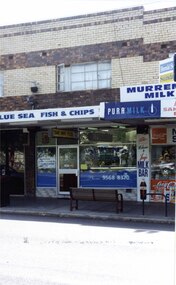
Photograph, Murrumbeena Road, 229A, Murrumbeena, 2001
Originally labelled "Beauville Estate, Established 1936, Still Thriving 65 years on, 10th March 2001", the Beauville Estate Album contains colour photographs of houses in the Estate. They were taken around the time of the Beauville Estate’s 65th Heritage Celebration held on 10/03/2001 and donated to the Caulfield Historical Society shortly afterwards. Photographer unknown. From Glen Eira’s Heritage Management Plan by Andrew Ward (1996) Vol 2 p78: In Murrumbeena Road, the shops which form part of the estate are a simple cream brick row relieved by manganese bricks in bands across the upper storeys.City of Glen Eira’s Heritage Management Plan Vol 2 p79 (this is p84 of the pdf version) – HO12 Beauville Estate and environs, Murrumbeena: The Beauville Historic Area is important at the State level as the first large housing estate undertaken by the AV Jennings Construction Co, later Jennings Group Limited, Victoria’s largest home builder. It is important also as a very early estate development incorporating a range of features other than houses and including made roads, shops and recreation facilities. In this respect it was the forerunner of the comprehensively planned housing estate of the post war era. The estate is distinguished by its aesthetic values, as is the earlier and comparable Hillcrest Estate, which are formed by a combination of restrained diversity in house styles, with the exception of no. 30 in the emerging International style, and by a landscaped garden environment. Colour photograph of a section of a double storey, unpainted brick, commercial property containing shops at ground level all with awnings over the footpath. This specific property is a fish and chip shop. The upper storey brick residence features a curtained window, a flat roof and decorative two tone bands of brickwork. It has a large street seat on the footpath out front.BLUE SEA FISH & CHIPS / TAKE AWAY FOODmurrumbeena, architectural styles, 1930's, inter war style, a.v. jennings, av jennings, jennings, beauville estate, murrumbeena road, milk bars, commercial establishments, flats, fish & chip shops, sir albert victor jennings, a v jennings construction co, beauville estate heritage area, glen eira city council, architectural features, jennings group limited, land subdivision, beauville historic area, brick features, restaurants -
 Glen Eira Historical Society
Document - St. James Parade, 29, Elsternwick
2 items about this property: 1/Two newspaper ads, dated 01/06/2002 and 17/02/2010. Includes five photographs and brief details of home for forthcoming auction. 2/Handwritten research on former occupiers of property from Sands and McDougall on 15/03/2013.st. james parade, elsternwick, edwardian, architectural features, lead lights, brick, bay windows, perrior arth w. -
Glen Eira Historical Society
Newspaper - St. James Parade, 26, Elsternwick
2 items about this property: 1/Two newspaper articles dated 30/03/2005 and 8/04/2005 giving home feature details prior to auction. 2/Resarch, handwritten by Claire Barton, on former occupiers of number 26 St. James Parade.st. james parade, elsternwick, brick, architectural features, fireplaces, bay windows, verandahs, dwyer w.f., porter minnie w. mrs. -
Glen Eira Historical Society
Pamphlet - ARTHUR STREET, 15, CAULFIELD NORTH
2 items relating to 15 Arthur Street: 1/Newspaper article from Property Review Weekly, on forthcoming sale of property, includes photograph. 2/Gary Peer flyer, includes 4 photographs of home and house plan for forthcoming auction.caulfield north, arthur street, edwardian style, brick, lead lights, jeffries emma mrs., toohey jno w., white alick, hart m.g. mrs., green godwin a., mitton g. m., brown t. mrs., samuel lear, samuel aviv -
Glen Eira Historical Society
Pamphlet - Stanley Street, 21, Elsternwick
This file contains two items about this property: 1/Auction flyer dated 31/08/2013 which includes a black and white photograph of home plus details of residence’s features, including terms of sale 2/Handwritten research by Claire Barton on former owners of property dated 12/03/2013stanley street, elsternwick, cox bros., real estate agents, glen huntly road, glenhuntly road, tonks w.b, auctioneers, thompson p.w, thompson harriet, brick, house names, spanish mission, architectural features, carre thos. w, “cavers carre”, riddell w.j. carre -
Glen Eira Historical Society
Article - St James Parade, 6, Elsternwick
This file contains two items about this property: 1/Newspaper advertisement which includes two photographs of home with brief details of selling features, dated March 2011likely from the Glen Eira Leader. 2/Hand-written research (1 page) by Claire Barton on former occupiers of 6 St. James Parade, undated. Period covered is 1942-1960.st. james parade, elsternwick, gardenvale station, glenhuntly road, brick houses, dutty avenue, congress w.e., mathews geo j., gardenvale road -
Glen Eira Historical Society
Document - St James Parade, 13, Elsternwick
This file contains two items about this property: 1/Newspaper advertisement dated June 2011 including one coloured photo and brief details of home. 2/Hand-written research on former occupiers of property by Claire Barton dated 15/03/2013 for period 1942-1960.st. james parade, elsternwick, architectural features, bay windows, plaster moulds, brick, penduck edwd, hill chas h., glen huntly road -
Glen Eira Historical Society
Ephemera - Stanley Street, 18, Elsternwick, 'St Elvins'
Three items about this property: 1/Newspaper advertisement including 3 coloured photos dated 2008, giving details of home interior. 2/Auction flyer with three coloured photos and plan of house and grounds. 3/Handwritten research by Claire Barton taken from Sands & McDougall directories of occupiers of 18 Stanley Streetstanley street, elsternwick, st elvins, house names, brick, leadlights, bay windows, glen huntly road, arts and craft, architectural style, beaumont mrs m e, beaumont harold, egan mrs h, guesthouses, wood colin h, carre street, orrong road, farrell misses, st quentin's ladies school, hartshorn mrs, sproule mary e mrs, little emma mrs, jenkin s mrs, farrell grace, farrell gertrude, sewell frank b, lindsay j -
Glen Eira Historical Society
Document - Burreel
... Mary Nursing homes Alexander Enid Cellars Bricks Bluestone ...This file contains one item. 1. Auction leaflets for two periods of sale, 5 April and 30 April, years unknown, possibly 1990’s. Articles give same photograph of home, sketch of home and interior plan layout. Also includes history of Burreel to 1982/1983.burreel, biggin and scott, auctions, biggin kevin, lawson graeme, elsternwick, victorian style, mansions, stephen francis, glenhuntly road, buxton family, allen george, music, neate mary, nursing homes, alexander enid, cellars, bricks, bluestone, slate, verandas, fireplaces, plaster moulds, cool stores, gas lighting, cast iron works, architectural features, gardens -
Glen Eira Historical Society
Article - Dorothy Avenue, 20, Glen Huntly
This file contains four items about this property: 1/6 pages on history of 20 Dorothy Avenue, 4 pages are photocopied photographs of home exterior and interior. 2/Printout from Museum Victoria website showing model of D C Gallager House Glenhuntly, designed by A V Jennings’ first architect Edgar Gurney. 3/Photocopied article from unknown source about proposals to add another story to their house in 1977/1978. 4/Photocopy of Certificate of Title for 20 Dorothy Avenue, Glenhuntly.d. c. gallager house, glenhuntly, a v jennings, gurney edgar, architects, barnard e. f., dorothy avenue, macgowan avenue, house styles, brick, gallagher dudley chas, glenhuntly road, newsagents, dargie william alexander, artists, martin ernest james, mechanics, marek christine, marek joseph, dargie kathleen, dargie roger, dargie faye, charlestworth ted, quin damien, rooms, architectural features, architectural styles -
Glen Eira Historical Society
Document - St. James Parade, 22, Elsternwick
Two items about this property: 1/Newspaper advertisement dated 16/03/2002, includes 2 photos and brief details of home for forthcoming auction. 2/Hand written research on former occupiers at property done by Claire Bardon on 15/03/2013 from Sands & McDougall.st. james parade, elsternwick, californian bungalow, architectural style, lead lights, brick, verandas, architectural features, spigler k, mckellor john f -
 Glen Eira Historical Society
Album - Album page, Paynswicke, Gladstone Pde & Hartington St, Circa 1972
This photograph is part of the Caulfield Historical Album 1972. This album was created in approximately 1972 as part of a project by the Caulfield Historical Society to assist in identifying buildings worthy of preservation. The album is related to a Survey the Caulfield Historical Society developed in collaboration with the National Trust of Australia (Victoria) and Caulfield City Council to identify historic buildings within the City of Caulfield that warranted the protection of a National Trust Classification. Principal photographer thought to be Trevor Hart, member of Caulfield Historical Society. Most photographs were taken between 1966-1972 with a small number of photographs being older and from unknown sources. All photographs are black and white except where stated, with 386 photographs over 198 pages. House is commonly spelt as "Payneswicke".From: Glen Eira Heritage Management Plan (1996) by Andrew Ward and Associates "Payneswicke" is locally significant as a prominent and substantially intact villa of its period, distinguished by its cast cement enrichment, unpainted stuccoed surfaces and commanding aspect to the south-west. Its role for a period as home for local builder, Patrick Millane (compare no. 11 Gladstone Parade) is of interest. In 1889, a nine roomed brick house was in the course of erection on the site. The house was completed in 1890 and Millane took up residence. Millane continued as owner/ occupant in 1894. However, in 1899, although Millane still occupied the house, ownership had been taken over by the Land Mortgage Bank. By 1910, Andrew Brown was occupant. Occupancy passed to Edward Brown by 1920 and to Miss A.N. Brown by 1930. Miss Brown continued to live there in 1941.Page 50 of Photograph Album with three exterior photographs (2 landscape and 1 portrait) of Paynswicke, a double storey house.Hand written: No 13 [top right] / "Paynswicke" N.E. cnr Gladstone Pd & Hartington St [top right] / 8 Oct 1966 [under top left photo] / 50 [bottom right] trevor hart, 1880's, 1890's, payneswicke, patrick millane, gladstone parade, unpainted stuccoed surfaces, cast cement enrichment, hartington street, villa residence, italianate, elsternwick, victorian, mansion, cast iron verandahs, return verandahs, curved windows, full length windows, land mortgage bank, andrew brown, edward brown, a n brown, paynswicke -
 Glen Eira Historical Society
Album - Album page, Glenferrie Street, 4, Circa 1972
This photograph is part of the Caulfield Historical Album 1972. This album was created in approximately 1972 as part of a project by the Caulfield Historical Society to assist in identifying buildings worthy of preservation. The album is related to a Survey the Caulfield Historical Society developed in collaboration with the National Trust of Australia (Victoria) and Caulfield City Council to identify historic buildings within the City of Caulfield that warranted the protection of a National Trust Classification. Principal photographer thought to be Trevor Hart, member of Caulfield Historical Society. Most photographs were taken between 1966-1972 with a small number of photographs being older and from unknown sources. All photographs are black and white except where stated, with 386 photographs over 198 pages. From Glen Eira Heritage Management Plan 1996 by Andrew Ward: In 1905, most of portion 27 was vacant land, however Glenferrie Street had been formed and the land subsequently subdivided. In 1906, Robert Joseph Haddon, architect and painter, designed and built for his private residence, a brick house on the west side. Haddon named the house "Anselm". Also built on the property were a garage and fibro cement studio. "Anselm" is architecturally important at the State level as a substantially intact, highly personalised and boldly expressed house expressive the Arts and Crafts movement and incorporating Art Nouveaux enrichment in a variety of forms, the use of ornamental terra cotta tiles to the comer tower being of special note. Its importance at the State level is strengthened by its place as the home of the noted architect and Melbourne's most influential exponent (Freeland, J.M., Architecture in Australia, p. 213) of the Art Nouveaux movement.https://vhd.heritagecouncil.vic.gov.au/places/4442 Victorian Heritage Register: What is significant? Anselm was designed by noted English born architect Robert Joseph Haddon(1866-1929) as his own house and constructed in 1906. A single storey Arts and Crafts influenced red brick house with attic, Anselm has a pyramidal slate roof with prominent chimney stacks. There is a octagonal corner tower with saucer shaped domed roof surmounted by a weather vane, and the tower has decorative terracotta panels immediately below the eaves line. The front door opens immediately into a large living or common room, screened from view by a timber and bottle glass screen. The large room was designed to function as a drawing and dining room. The house is rich with hand crafted details including door and window furniture, wrought iron gutter brackets, fireplaces (one with built in wood box), and fire tools. The interior decoration includes hand painted frieze of Port Phillip in the study, and a hand painted frieze of turbulent sea with sailing boats in the tiled bathroom. There is a small hand painted tile at the base of the tower which states ?This building was erected AD1906 from designs by Robt J Haddon FRIBA,Lond FRIVA Melb Architect?. He also designed an attic addition which was constructed in 1927. Anselm is substantially intact although the double casement window immediately to the south of the front door was originally circular....Page 60 of Photograph Album with three exterior photographs (one portrait and two landscape) of Anselm.Hand written: 4 Glenferrie Street [top right] / ANSELM 4 Glenferrie St [under top photo] / 60 [bottom right] trevor hart, anselm, art nouveaux, arts and crafts, tower, bay window, glenferrie street, robert joseph haddon, 1900's, terra cotta tiles, double storey, caulfield north, corner tower, gates, cast iron work -
 Glen Eira Historical Society
Album - Album page, Glenferrie Street, 4, Circa 1972
This photograph is part of the Caulfield Historical Album 1972. This album was created in approximately 1972 as part of a project by the Caulfield Historical Society to assist in identifying buildings worthy of preservation. The album is related to a Survey the Caulfield Historical Society developed in collaboration with the National Trust of Australia (Victoria) and Caulfield City Council to identify historic buildings within the City of Caulfield that warranted the protection of a National Trust Classification. Principal photographer thought to be Trevor Hart, member of Caulfield Historical Society. Most photographs were taken between 1966-1972 with a small number of photographs being older and from unknown sources. All photographs are black and white except where stated, with 386 photographs over 198 pages. From Glen Eira Heritage Management Plan 1996 by Andrew Ward: In 1905, most of portion 27 was vacant land, however Glenferrie Street had been formed and the land subsequently subdivided. In 1906, Robert Joseph Haddon, architect and painter, designed and built for his private residence, a brick house on the west side. Haddon named the house "Anselm". Also built on the property were a garage and fibro cement studio. "Anselm" is architecturally important at the State level as a substantially intact, highly personalised and boldly expressed house expressive the Arts and Crafts movement and incorporating Art Nouveaux enrichment in a variety of forms, the use of ornamental terra cotta tiles to the comer tower being of special note. Its importance at the State level is strengthened by its place as the home of the noted architect and Melboume's most influential exponent (Freeland, J.M., Architecture in Australia, p. 213) of the Art Nouveaux movement. Victorian Heritage Register https://vhd.heritagecouncil.vic.gov.au/places/4442 What is significant? Anselm was designed by noted English born architect Robert Joseph Haddon(1866-1929) as his own house and constructed in 1906. A single storey Arts and Crafts influenced red brick house with attic, Anselm has a pyramidal slate roof with prominent chimney stacks. There is a octagonal corner tower with saucer shaped domed roof surmounted by a weather vane, and the tower has decorative terracotta panels immediately below the eaves line. The front door opens immediately into a large living or common room, screened from view by a timber and bottle glass screen. The large room was designed to function as a drawing and dining room. The house is rich with hand crafted details including door and window furniture, wrought iron gutter brackets, fireplaces (one with built in wood box), and fire tools. The interior decoration includes hand painted frieze of Port Phillip in the study, and a hand painted frieze of turbulent sea with sailing boats in the tiled bathroom. There is a small hand painted tile at the base of the tower which states ?This building was erected AD1906 from designs by Robt J Haddon FRIBA,Lond FRIVA Melb Architect?. He also designed an attic addition which was constructed in 1927. Anselm is substantially intact although the double casement window immediately to the south of the front door was originally circular....Page 61 of Photograph Album with one exterior photograph (portrait) of Anselm.Hand written: 61 [bottom left] trevor hart, anselm, art nouveaux, arts and crafts, tower, bay window, glenferrie street, robert joseph haddon, 1900's, terra cotta tiles, double storey, caulfield north, corner tower, brick house, attics -
Glen Eira Historical Society
Document - Queen’s Avenue, 46, Carnegie
This file contains two items: 1/ A photocopied 3 page article on 46 Queen’s Avenue, Carnegie taken from the ‘Australian Home Beautiful’, 01/11/1938. Describes home interior design features and exterior building character features, designed and built by W.L. Fritzlaff for Mr. and Mrs. Norman Meyers, veterinary surgeon. 2/Handwritten document from Sands and McDougalls gives owners of number 46 from 1938 to 1960, researched by Claire Barton dated 18/02/2014.the australian home beautiful, caulfield, queens avenue, queen’s avenue, meyers norman, caulfield racecourse, physicians, fritzlaff w.f., builders, brick houses, leek miss j.m., lolagis m.n., leek horace, trainers, cooke murray, harrison ida r mrs, meyers chas. l., veterinary surgeons -
 Federation University Historical Collection
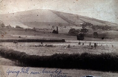
Photograph (Black & White), Spring Hill Near Creswick
Both images are associated with Ellie Campbell. James and Bridget Martin were early settlers at Spring Hill. All their children attended the Ballarat School of Mines..1) A black and white image of Spring Hill near Creswick, glued into a thick card with a gold gilt edge. .2) Martin family house at Subiaco Hill, Western Australia. Brick house built by Corby Statford Cambell, Elly Campbell's father. .1) Written in blue pen on front of photograph 'Spring Hill near Creswick - Victoria' Taped onto back 'Farmland allotted to James George Martin in c1849. He took his bride, Bridget Hyde (19 years old) by bullock dray from St James Church, Elizabeth Street, Melbourne to this new allotment - 10 children born there - William, Robert, Samuel, Elizabeth, Ellen, Emily, Mary (died 2 months old mother also died). J.G.M. moved to Ballarat - attended Dawson Street Baptist Church. Here he married a widow with 2 sons, Mrs ____. Her 2 sons were born, George and Charles (was in USA) . Children all attended School of Mines, Ballarat .2) On yellow sticky label with photo - "Family home Subiace Rd Subiac WA. Builtby Statford Campbell, Elly's fayher. Now Coppin St.ballarat school of mines, william martin, james martin, bridget martin, bridget hyde, samuel martin, elizabeth martin, ellen martin, mary martin, george martin, charles martin -
 Federation University Historical Collection
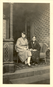
Photograph - Photograph - Black and White, Laura Ritchie and Sarah Wright at 214 Armstrong (Nth) Street, Ballarat, late 1920's
Sarah Wright was married to a gold miner named William. They lived at Laura Villa, Smeaton. Their family won many singing and instrumental awards. Frank Wright their son was born and attended Smeaton State School and was a renown resident of Smeaton. Frank was tutored by Percy Code and was awarded a gold medal for the highest marks in the ALCM examinations in the British Colonies at the age of seventeen years. He became the Australian Open Cornet Champion by the age of eighteen. A year later, Frank conducted the City of Ballarat Band, and later the Ballarat Soldiers’ Memorial Band. He formed the Frank Wright Frisco Band and Frank Wright and his Coliseum Orchestra. These bands won many South Street awards, and Frank as conductor won many awards in the Australian Band Championship contest. In 1933 Frank Wright sailed to England to conduct the famous St Hilda’s Band and was later appointed Musical Director of the London County Council, where he organized many amazing concerts in parks, in and around the London district. He was made Professor of Brass and Military Band Scoring and conducted at the Guildhall of Music and Drama. Frank was often invited to adjudicate Brass Band Championships around Europe, in Australia, including South Street and in New Zealand. The Frank Wright Medal at the Royal South Street competition is awarded to an individual recognized as making an outstanding contribution to brass music in Australia. Laura Ritchie was his sister and lived in Ballarat with her family. A black and white photo of two women sitting on a wicker couch on the verandah of a brick house. The older woman is wearing a dressing gown and slippers and the younger woman is wearing a light coloured suit. The women are Sarah Wright and her daughter Laura Ritchie. The house is Laura's home at 214 Armstrong Street Nth, BallaratWritten in pencil 214 Armstrong St Nth, Laura and Sarah Wrightsarah wright, laura ritchie, frank wright, cornet, ballarat -
 Federation University Historical Collection
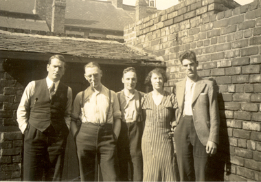
Photograph - Black and White, Visitors to the home of George Olver, South Shields, 1934, Sept 1934
Frank Wright was a renown resident of Smeaton, where he was born. He lived at Laura Villa, and attended Smeaton State School. His father William was a gold miner and his mother's name was Sarah. Their family won many singing and instrumental awards. Frank was tutored by Percy Code and was awarded a gold medal for the highest marks in the ALCM examinations in the British Colonies at the age of seventeen years. He became the Australian Open Cornet Champion by the age of eighteen. A year later, Frank conducted the City of Ballarat Band, and later the Ballarat Soldiers’ Memorial Band. He formed the Frank Wright Frisco Band and Frank Wright and his Coliseum Orchestra. These bands won many South Street awards, and Frank as conductor won many awards in the Australian Band Championship contest. In 1933 Frank Wright sailed to England to conduct the famous St Hilda’s Band and was later appointed Musical Director of the London County Council, where he organized many amazing concerts in parks, in and around the London district. He was made Professor of Brass and Military Band Scoring and conducted at the Guildhall of Music and Drama. Frank was often invited to adjudicate Brass Band Championships around Europe, in Australia, including South Street and in New Zealand. The Frank Wright Medal at the Royal South Street competition is awarded to an individual recognized as making an outstanding contribution to brass music in Australia.Black and white photograph of a group of four men and one woman standing in front of a brick wall of a house. The roof with several chimneys extend to the top of the photo. The people are from left to right Frank Wright, Geo Oliver, Bill Clegg, Mrs Oliver and Bill Oughton. The place is South Shields, England.Written in pencil of back - Frank Wright (left), Geo Oliver, Bill Clegg, Mrs Oliver, Bill Oughton at the home of Geo Oliver, South Shields. Sept 1934frank wright, george olver, bill clegg, mrs olver, bill oughton, south shields -
 Flagstaff Hill Maritime Museum and Village
Furniture - Set of desks & benches, Unknown
The following are the recollections of John Elkins, who started school in February, 1945 at Maryborough in Queensland, Australia. 'I think in Prep 1 that we had some paper to write on with pencils, but my memory of the routine use of slates is much more vivid. Each slate was framed in wood and one side was inscribed with lines to guide the limits for the upper and lower extremities of letters. The slate "pencils" were made of some pale gray mineral softer than slate which had been milled into cylinders some one-eighth of an inch in diameter and inserted into metal holders so that about an inch protruded. Each student was equipped with a small tobacco tin in which was kept a damp sponge or cloth to erase the marks. Sharpening slate pencils was a regular task. We rubbed them on any suitable brick or concrete surface in the school yard. Teachers also kept a good supply of spares, all writing materials and books being provided by the school. It is possible that the retention of slates stemmed from the political imperative that public education should be free. I do recall being given a Copy Book for home practice of letter formation, a typical practice until Grade 6. The tables at which we used to sit in the Infant School were replaced in the primary Grades by long desks seating five or six pupils. These had slots into which the slates could be inserted vertically. When the teacher asked the class to clear their desks, the command issued was "slates away!" This was an occasion for a noisy expression of relief as we dropped the slates producing a sound not unlike a volley of rifle shots, and usually brought a request from the teacher to repeat the process with no noise by holding the frames throughout. Thus, I suspect we may still have used slates in Grade Three, though by then paper, which may have been scarce during the War, seemed to be used more routinely.' The full context of John's account of writing during his primary school days can be found at: https://www.readinghalloffame.org/sites/default/files/history_of_literacy_22slates_away22_penmanship_in_queensland_australia.pdfSchool desks and benches/chairs have been in use in schools since formal group education started.Eight long school desks (five higher three lower), each with four inkwells and groove along length. eight school benches (five higher three lower). Each desk and bench accommodates four children.None.flagstaff hill, warrnambool, shipwrecked-coast, flagstaff-hill, flagstaff-hill-maritime-museum, maritime-museum, shipwreck-coast, flagstaff-hill-maritime-village -
 City of Moorabbin Historical Society (Operating the Box Cottage Museum)
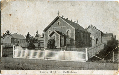
Photograph - Black & White Postcard, Cheltenham Church of Christ 40th Anniversary Invitation, c1900
On his arrival from Scotland c 1857, James Keir commenced a communion service in his home on the Nepean Road. By 1859 the group-which included such other names as Allen, Brough, Cameron, Fairlam, Holdsworth, Le Page, Meeres, Monk, Organ, Penny, Perry, Potts, Sears and King-had built a small chapel near the corner of Wickham and Chesterville Roads. During 1858, a group had also begun meeting in the Charman family home on the corner of Charman and Balcombe Roads. Names associated with this group included Bodley, Charman, Fisher, Hayes, Hilliar, Judd, Moysey and Ruse. In 1860 they built a chapel on the corner of Charman Road and Patty Street. It was enlarged in 1866 and it became the meeting place of the two groups when they came together around 1870. They were able to buy land near the corner of Chesterville and Nepean Roads, and erected a new brick chapel on the site in 1878. This chapel, of course, continues to be an integral part of the life of the Southern Community Church and was one of the three worship venues for the 150th Anniversary celebration in 2007. The Southern Community Church was formed by the amalgamation of the Cheltenham, East Bentleigh and Hampton Street Churches of Christ in 1993, and a comprehensive new facility was designed and built to accommodate the ever-increasing activity of the amalgamated church. It was opened on 30th November 1997. ( Southern Community Church website 2019)c1878 - continuing The Church or Christ Cheltenham was one of the first places of worship established in Cheltenham by the early settlers. The settlers came together, in private homes at first, to support each other spiritually and physically and later built brick Churches for Sunday services and established social and sporting clubsBlack & White photograph as a postcard invitation to the 40th Anniversary of the Church of Christ corner Chesterville Rd and Nepean Highway Cheltenham ( ? 1900)Front Printed ; Church of Christ Cheltenham Back Printed ; POST CARD / One Penny Postage within Commonwealth / The address only to be written here/ One penny Stamp/ Sunday School Anniversary, / OCTOBER 27TH & OCTOBER 30TH / TO WHICH YOU ARE / CORDIALLY INVITED Handwritten in ink ; H.W. got the cramps in the pants. He took some pills then ran over the hills undatedearly settlers, bentleigh, mckinnon, parish of moorabbin, city of moorabbin, county of bourke, moorabbin roads board, shire of moorabbin, were j.b., o'shannassy john, king richard, charman stephen, highett william, ormond francis, maynard dennis, market gardeners, vineyards, orchards, keir james, lepage frank, lepage everest, holloway josiah, bruton henry, keys robert, judd clarence, fairlam percy, meeres william, southern community church, cheltenham, cheltenham church of christ -
 City of Moorabbin Historical Society (Operating the Box Cottage Museum)
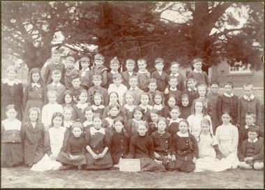
Photograph, Black & White, x2 Cheltenham State School No.84 Charman Rd c 1910, c1910-20
Stephen Charman, 1821-1906 a market gardener, donated land for the first Methodist Chapel, Cemetery and School in Charman Rd Cheltenham 1855. The enrollment was 36 pupils with Mr Frederick Meeres as Teacher. 1863 the school is called Beaumaris Common School No 84 with 70 pupils and Walter Meeres as Teacher. 1869 another 2 acres in Charman Road were granted by the Education Board and brick building built . 1872 State School 84 Beaumaris was increasing enrollments and 1878 a new brick school was built to accommodate 174 pupils and the name changed to Cheltenham State School No.84 1894 Mentone State School No.2950 amalgamated with Cheltenham SS No.84. 1910 the buildings were in disrepair, overcrowding was increasing and renovations were made 1912 with further additions in 1925 and 1937. Post WW11 extra prefabricated Classrooms were added as enrollment increased to 1038 in 1955.. Cheltenham East State School 4754 was opened as housing development spread over the City of Moorabbin . (J.Larson Sandringham HS) The boys wearing round collars are from the Methodist Children's Home Cheltenham 1892-1953 that was situated on land now Southland Shopping Centre 1855 Stephen Charman donated land to the Methodist Church so that a School could be established to educate the children of the early settler market gardeners and farmers in the Cheltenham area . Education was valued by the general community and as well as schools they established mechanics Institutes and Libraries in Moorabbin Shire. Cheltenham State School No. 84 was among the first schools in Melbourne2x Black & White photographs of pupils at Cheltenham State School Charman Rd. c 1910-1920 a) Cheltenham State School No 84 c 1910 b) Cheltenham State School No.84 c 1910-1920 Grade 6a) Handwritten Cheltenham ( Charman Rd ) School / probably about 1910 b) " Charman Road School / taken probably between 1910 & 1920cheltenham primary school, methodist children's home cheltenham 1892-1953, city of moorabbin, county of bourke, moorabbin roads board, parish of moorabbin, shire of moorabbin, henry dendy's special survey 1841, were j.b., bent thomas, o'shannassy john, king richard, charman stephen, highett william, ormond francis, maynard dennis, cheltenham state school no.84, methodist chapel cheltenham, methodist school cheltenham, beaumaris west state school, meeres frederick, meeres walter, education, early settlers, cancel -
 City of Moorabbin Historical Society (Operating the Box Cottage Museum)
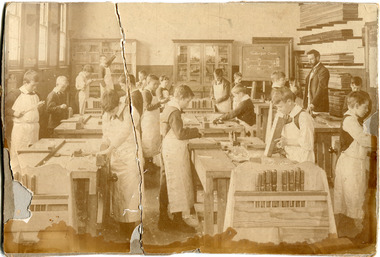
Photograph, Black & White, Cheltenham State School No 84 Woodworking Class c1910, c1910
Stephen Charman, 1821-1906 a market gardener, donated land for the first Methodist Chapel, Cemetery and School in Charman Rd Cheltenham 1855. The enrolment was 36 pupils with Mr Frederick Meeres as Teacher. 1863 the school is called Beaumaris Common School No 84 with 70 pupils and Walter Meeres as Teacher. 1869 another 2 acres in Charman Road were granted by the Education Board and brick building built . 1872 State School 84 Beaumaris was increasing enrollments and 1878 a new brick school was built to accommodate 174 pupils and the name changed to Cheltenham State School No.84 1894 Mentone State School No.2950 amalgamated with Cheltenham SS No.84. 1910 the buildings were in disrepair, overcrowding was increasing and renovations were made 1912 with further additions in 1925 and 1937. Post WW11 extra prefabricated Classrooms were added as enrollment increased to 1038 in 1955.. Cheltenham East State School 4754 was opened as housing development spread over the City of Moorabbin . (J.Larson Sandringham HS) The boys wearing round collars are from the Methodist Children's Home Cheltenham.1855 Stephen Charman donated land to the Methodist Church so that a School could be established to educate the children of the early settler market gardeners and farmers in the Cheltenham area . Education was valued by the general community and as well as schools they established mechanics Institutes and Libraries in Moorabbin Shire. Cheltenham State School No. 84 was among the first schools in Melbourne.Faded and cracked Black & White photograph showing pupils and teacher in the wood working class at Cheltenham State School No 84 c1910 -
 City of Moorabbin Historical Society (Operating the Box Cottage Museum)
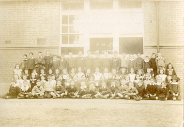
Photograph, Black & White x 2 Cheltenham State School 1913, 1913
Stephen Charman, 1821-1906 a market gardener, donated land for the first Methodist Chapel, Cemetery and School in Charman Rd Cheltenham 1855. The enrolment was 36 pupils with Mr Frederick Meeres as Teacher. 1863 the school is called Beaumaris Common School No 84 with 70 pupils and Walter Meeres as Teacher. 1869 another 2 acres in Charman Road were granted by the Education Board and brick building built . 1872 State School 84 Beaumaris was increasing enrollments and 1878 a new brick school was built to accommodate 174 pupils and the name changed to Cheltenham State School No.84 1894 Mentone State School No.2950 amalgamated with Cheltenham SS No.84. 1910 the buildings were in disrepair, overcrowding was increasing and renovations were made 1912 with further additions in 1925 and 1937. Post WW11 extra prefabricated Classrooms were added as enrollment increased to 1038 in 1955.. Cheltenham East State School 4754 was opened as housing development spread over the City of Moorabbin . (J.Larson Sandringham HS) The boys wearing round collars are from the Methodist Children's Home Cheltenham1855 Stephen Charman donated land to the Methodist Church so that a School could be established to educate the children of the early settler market gardeners and farmers in the Cheltenham area . Education was valued by the general community and as well as schools they established mechanics Institutes and Libraries in Moorabbin Shire. Cheltenham State School No. 84 was among the first schools in Melbourne.Faded, Black & White photograph x 2 of pupils at Cheltenham State School No. 84 1913 1st Group & 2nd GroupFront 1913city of moorabbin, county of bourke, moorabbin roads board, parish of moorabbin, shire of moorabbin, henry dendy's special survey 1841, were j.b., bent thomas, o'shannassy john, king richard, charman stephen, highett william, ormond francis, maynard dennis, cheltenham state school no.84, methodist chapel cheltenham, methodist school cheltenham, methodist children's home cheltenham 1892-1953, beaumaris west state school, meeres frederick, meeres walter, education, early settlers, cancel -
 City of Moorabbin Historical Society (Operating the Box Cottage Museum)
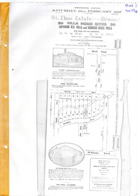
Flyer - St Elmo Estate, McKinnon / Ormond, 1927
The train line from the city to Frankston was electrified in 1922 which intensified the sale in the municipality of Moorabbin, particularly land which was in the vicinity of the railway stations.Example of the progress of the Municipality of MoorabbinThe train line from the city to Frankston was electrified in 1922 which intensified the sale in the municipality of Moorabbin, particularly land which was in the vicinity of the railway stations.St Elmo Estate, McKinnon Auction 19 February 1927 20 Villa Home Sites Superior W.B. Villa "St Elmo" and Modern Brick Villamurray road, hawthorn grove, ormond, mckinnon, real estate, auction