Showing 10039 items
matching dandenong
-
 Ringwood and District Historical Society
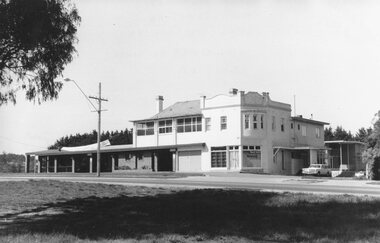
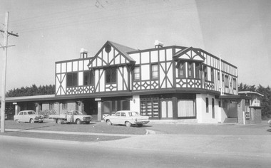
Photograph, Club Hotel, Mount Dandenong Road, East Ringwood in November 1969
Club Hotel, East Ringwood in November 1969Written on backing sheet, "Club 1969. Site originally marked out as local cemetery 1871. Hotel built as single storey 1877" The hotel has a long association with the Reddish family, thus given the name of "Daisy's Hotel". Ryman Healthcare bought the site in 2019, including the garden supply business next door, making up a 2.2ha area. The proposal was for a $220 million retirement village to be built. The location is next to Ringwood Lake with the old hotel being knocked down in the early 2020s. Was H17 in previous numbering system. -
 Ringwood and District Historical Society
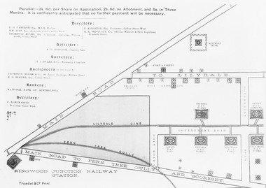
Photograph, Land sale brochure map of Ringwood's early main central area around Mount Dandenong Road - c.1880s
Catalogue card reads, 'Map of Ringwood East'. -
 Ringwood and District Historical Society
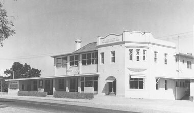
Photograph, Club Hotel, Mount Dandenong Road, East Ringwood in February 1960
Black and white photographs of Club Hotel February 1960 (1 original, three copies). The hotel has a long association with the Reddish family, thus given the name of "Daisy's Hotel". Included 2 copies of the photograph. Ryman Healthcare bought the site in 2019, including the garden supply business next door, making up a 2.2ha area. The proposal was for a $220 million retirement village to be built. The location is next to Ringwood Lake with the old hotel being knocked down in the early 2020s. -
 Ringwood and District Historical Society
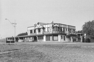
Photograph, Club Hotel, Mount Dandenong Road, Ringwood East 1973
Black and white photographs of Tudor style Club hotel -
 Ringwood and District Historical Society
Photograph, Club Hotel, Mount Dandenong Road, Ringwood East in June 1971
Black and white photographs of Tudor style two-storey building (2 originals, 1 copy). The hotel has a long association with the Reddish family, thus given the name of "Daisy's Hotel". Included 2 copies of the photograph. Ryman Healthcare bought the site in 2019, including the garden supply business next door, making up a 2.2ha area. The proposal was for a $220 million retirement village to be built. The location is next to Ringwood Lake with the old hotel being knocked down in the early 2020s. Was H9 in old numbering system.Club Hotel June 1971 -
 Ringwood and District Historical Society
Map - State Aerial Survey, Dandenong Ranges Area, Parishes of Warrandyte and Ringwood - 1956
Map of central and southern areas of Ringwood and part of Ringwood East and Heathmont compiled by Dept of Lands and Survey, July 1956, from aerial photographs and Cadastral Survey information. Subsequent hand-drawn addition of streets showing layout of "Township of Ballyduffy Estate 1858-60", an earlier proposed subdivision that did not eventuate. (See attached 5009b Ballyshanassy_ Melbourne’s lost suburb.pdf for Ballyduffy historical naming relevance). Ballyduffy Estate streets include City Road, West Prussia Road, Duffy Street, Ireland Street, Evans Street, Victoria Street, Regina Street, Short Road, Prussia Road, Duffy Street East, Ireland Street East, Evans Street East, Chapman Street. Misc Topo 93 Sheet 22, Ringwood A4B2. Scale: 4 chains to 1 inch. Contour interval 20 feet. -
 Ringwood and District Historical Society
Map - State Aerial Survey, Dandenong Ranges Area, Parts of Parishes of Nunawading, Warrandyte and Ringwood - 1956
Map of Ringwood North and parts of Mitcham, Donvale, Park Orchards and Ringwood East compiled by Dept of Lands and Survey, July 1956, from aerial photographs and Cadastral Survey information. Sheet 1, Ringwood A2D or 849 A2D Zone 7. Scale: 4 chains to 1 inch. Contour interval 20 feet. -
 Ringwood and District Historical Society
Map - State Aerial Survey, Dandenong Ranges Area Sheet 7, Parishes of Warrandyte, Scoresby, Ringwood and Nunawading - 1956
Map of central and southern areas of Ringwood and part of Ringwood East and Heathmont compiled by Dept of Lands and Survey, July 1956, from aerial photographs and Cadastral Survey information. Subsequent coloured hand-drawn additions showing layout of a number of post-NSW Separation era proposed subdivisions that did not eventuate, including Village of Studley Estate, Township of East Kew Estate, Township of Ballyduffy Estate, Township of New Flemington Estate, Township of East Hawthorne Estate. Ringwood A4B2, 849 A4B Zone 7. Scale: 10 chains to 1 inch. Contour interval 20 feet. -
 Ringwood and District Historical Society
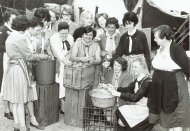
Photograph, Ida Oke and all at Dandenong Scouting Jamboree in 1965
Scanned on 30th January, 2008 from Ida Oke's albums. Ida lives in East Ringwood and also contributed to the East Ringwood Recollections book. Wife of Bob (Robert William) Oke. Both Ida and Bob were heavily involved in the Scout movement, as were Bob's parents - Corrie and Ruby (Guides) Oke, who both lived in Old Lilydale Road, East Ringwood. -
 Ringwood and District Historical Society
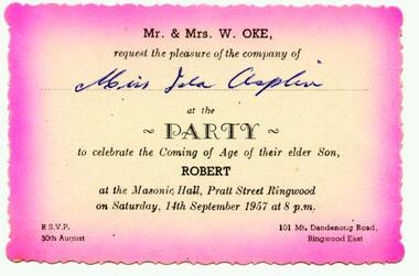
Photograph, Invitation from Mr and Mrs W Oke (101 Mt Dandenong Road, East Ringwood) to celebrate son Robert ("Bob") on his 21st at Ringwood Masonic Hall, Pratt St, Ringwood 1957
Scanned on 30th January, 2008 from Ida Oke's albums. Ida lives in East Ringwood and also contributed to the East Ringwood Recollections book. Wife of Bob (Robert William) Oke. Both Ida and Bob were heavily involved in the Scout movement, as were Bob's parents - Corrie and Ruby (Guides) Oke, who both lived in Old Lilydale Road, East Ringwood. -
 Victorian Aboriginal Corporation for Languages
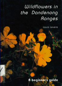
Book, Laura Levens, Wildflowers in the Dandenong Ranges : a beginner's guide, 1997
Small format book. Chapters organised according the colour of the flowers.Colour photographs, glossarywildflowers, plants, dandenong ranges -
 Koorie Heritage Trust
Book, Brennan, Niall, Chronicles of Dandenong, 1973
The index to this book is very limited, leaving out a number of important entries particularly the aborigines, native police and early missions. His research extends from the Aborigines in the early days through to the great industrial sites which Dandenong now possesses.pp142; maps; illus.; 25 cm.The index to this book is very limited, leaving out a number of important entries particularly the aborigines, native police and early missions. His research extends from the Aborigines in the early days through to the great industrial sites which Dandenong now possesses.aboriginals-narug-wilam; nunurong., native police, dandenong-history, langhorne, george -
Whitehorse Historical Society Inc.
Map, Dandenong Ranges Area, 1956
Sheet 1. Parts of Parishes: Nunawading, Warrandyte and Ringwood. Scale: 10 chains : 1 inch. Contour intervals marked and locations of buildings.Sheet 1. Parts of Parishes: Nunawading, Warrandyte and Ringwood. Scale: 10 chains : 1 inch. Contour intervals marked and locations of buildings. Compiled from aerial photographs and cadastral survey information.Sheet 1. Parts of Parishes: Nunawading, Warrandyte and Ringwood. Scale: 10 chains : 1 inch. Contour intervals marked and locations of buildings. maps, ringwood, mitcham, warrandyte -
Whitehorse Historical Society Inc.
Map, Dandenong Ranges Area, 1955
Sheet 13. Parts of Parishes: Nunawading, Mulgrave and Scoresby.Sheet 13. Parts of Parishes: Nunawading, Mulgrave and Scoresby. Includes area of Vermont South marked as proposed Township of Norwich. Scale 10 chains : 1 inch. Contours marked.Sheet 13. Parts of Parishes: Nunawading, Mulgrave and Scoresby. maps, vermont south, wantirna, dandenong creek -
Whitehorse Historical Society Inc.
Map, Dandenong Ranges area. Sheet 7, c1957
Detailed map covering area from Mitcham and Vermont to Ringwood and Heathmont.Detailed map covering area from Mitcham and Vermont to Ringwood and Heathmont. Shows streets, block boundaries, buildings, railway and creeks. Note says prepared from State Aerial Survey, April 1954 and Cadastrial Survey information July 1956.Detailed map covering area from Mitcham and Vermont to Ringwood and Heathmont. maps, mitcham, vermont, ringwood, heathmont -
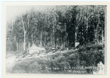 Mt Dandenong & District Historical Society Inc.
Photograph, Side View Mr G. Barber Homestead Mt Dandenong, c1905
Built in 1898 by early settler George Barber the property is still in existence today. It was the home of George, wife Sarah Ann and daughter Ethel.Black and white photograph showing te side view of George Barber's home, later named Forest Edge. c1905. Reverse of photograph has handwritten description by John Lundy-Clarke.Barber's home on Olinda Creek. Lot 25 Sect 1 Village Settlement. Home of George Barber and wife Sarah Ann (nee Richardson). Daughter Ethel.Was bought by Munnerley later Sangster and Kinnear. Later known as Forest Edge. Buggy and wagon shed on right. Photo copied 1973 by JLC. -
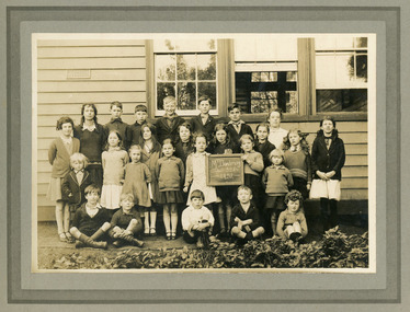 Mt Dandenong & District Historical Society Inc.
Photograph, Mt Dandenong School 3284 1932, 1932
Formal School photograph taken of students in front of school building in 1932.On back of photograph a stamp: G.E.HAINS Photographer 61 HARCOURT ST. HAWTHORN EAST. E3 1/6school, mt dandenong state school, mount dandenong, mt dandenong -
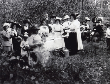 Mt Dandenong & District Historical Society Inc.
Photograph, Tea Time at the Mount Dandenong Golf Club at Mountain Grange 1912, 1912
A 9 hole golf course was laid out somewhere in the grounds of Mountain Grange.mountain grange, golf course -
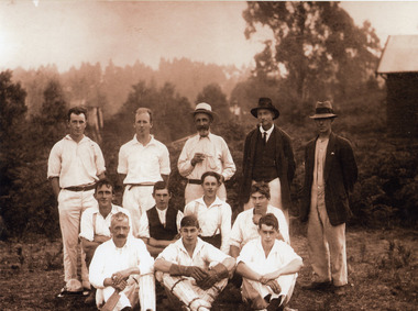 Mt Dandenong & District Historical Society Inc.
Photograph, Mount Dandenong Cricket Club at Mountain Grange, 1912
Photograph shows ten men in cricket gear & two in ordinary clothes. Names not recorded. The grounds at Mountain Grange were used for sport long before 1939 when Lillydale Council purchased the property to use as a public reserve and it later became the Kalorama Memorial Reserve.kalorama memorial reserve, mountain grange, cricket -
 Mt Dandenong & District Historical Society Inc.
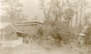
Photograph, Post Office Mt Dandenong North c1911, c1911
Landscape view. Mountjoy on hill, post office and residence with fence and sign post. Mrs Eliza Hand and (probably) Miss Florence hand outside. Another person standing on Ridge Road on the left. On right, the Methodist Church.eliza hand, florence hand, methodist church, mountjoy, mt dandenong north, post office, ridge road -
 Mt Dandenong & District Historical Society Inc.
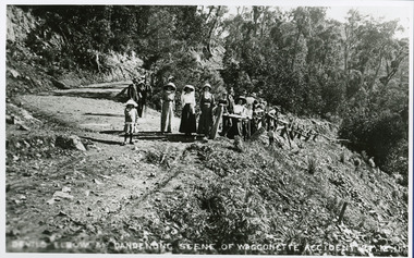
Photograph, Devil's Elbow at Mt Dandenong Scene of Waggonette Accident 27.12.11, 1911
Accident occurred at Devil's Elbow where now the Old Coach Road and Jasper Road meet at a cliff face. John Lundy-Clarke made a ballad about the mishap. The waggonnette was returning from an excursion to the Brooklyn Guest House in Montrose. The horses were killed and passengers presumably injured (a doctor attended). See 'The Brooklyn Dray".john lundy-clarke, kalorama, devil's elbow, wagonette -
 Mt Dandenong & District Historical Society Inc.
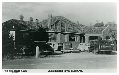
Photograph, Mount Dandenong Hotel, Olinda, Vic, c1950
Rose Series Postcard number 4971Copy of Rose Series postcard #4971 showing the car park c1950. Pre war and early post war cars. Note the Service Car to the right. You booked a seat and travelled door to door to the city in comfort.mount dandenong hotel, mount dandenong, service car -
 Mt Dandenong & District Historical Society Inc.
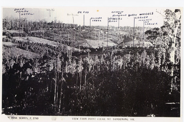
Photograph, View from Point Clear, Mt Dandenong, Vic
Rose Series Postcard number 2783Copy of Rose Series postcard #2783 showing view from Point Clear. This is taken from Ridge Road. The following indicators have been marked on the photograph L-R Dulce Domun Hotel, White's, Rev. Davies, Dr. Cox, Olinda Creek, Dickens Road, Church of England, Buggy Wheels Corner, Monash Ave. Corner.mount dandenong, ridge road, rose series, point clear -
 Mt Dandenong & District Historical Society Inc.
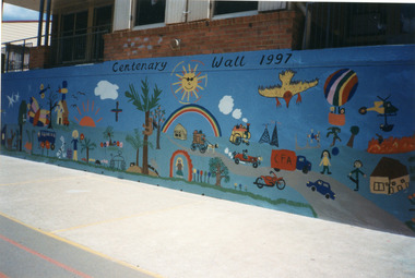
Photograph, Mount Dandenong Primary School 1997, 1997
Section of Centenary Mural painted by parents and students to commemorate the school centenary 1897 - 1997.mount dandenong, mt dandenong school -
 Mt Dandenong & District Historical Society Inc.
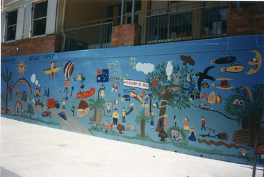
Photograph, Mount Dandenong Primary School 1997, 1997
Colour photograph of section of mural wall painted by parents and students to commemorate the school centenary 1897 - 1997.mount dandenong, mt dandenong school -
 Mt Dandenong & District Historical Society Inc.
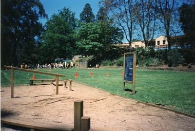
Photograph, Mount Dandenong Primary School 1997, 1997
The Exersite equipment allowed for student and public use. The equipment was removed when the oval was refurbished in 2004.View of 'Exersite' equipment at bottom corner of school oval with students participating in Sports day in the background. 1997.mount dandenong, mt dandenong school, exersite -
 Mt Dandenong & District Historical Society Inc.
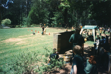
Photograph, Mount Dandenong Primary School 1997, 1997
View of Sports Day looking down over the oval with the 'rebound Wall' in the foreground 1997.mount dandenong, mt dandenong school -
 Mt Dandenong & District Historical Society Inc.
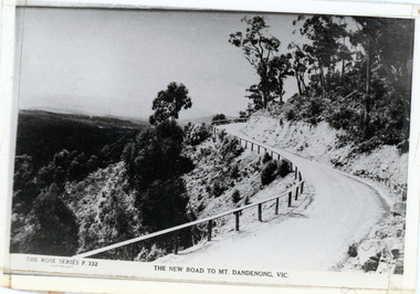
Photograph, The New Road to Mt. Dandenong, Vic
Copy of Rose Series postcard #332Copy of Rose Series postcard #332 showing a windy bend on the new road c1924. This photograph has a detailed inscription on the back handwritten by John Lundy-Clarke in 1974.The Windy Bend in 1924. Landslide of 1971 occurred at lower right hand corner.mt dandenong road, rose series, windy bend, landslide -
Southern Sherbrooke Historical Society Inc.
Book, "The Conservation of Sites and Structures of Historical and Archaelogical Significance in the Upper Yarra Valley and Dandenong Ranges Region", 1978
The work in two volumes, "Vol.1" containing the report with the exception of Chapter 5, which is the list and description of sites, and an unnumbered volume containing the entire report, was cancelled from the Belgrave branch of the Eastern Regional LibraThe publication, referred to as the Tansley Report, was prepared in 1978 as part of a Bachelor of Town & Regional Planning degree. It contains sections on conservation, pre-history and history of the area, and a list of significant sites. This is a photocopy of the original report. -
Southern Sherbrooke Historical Society Inc.
Map, Dept of land s & Survey, Dandenong Ranges Area Sheet 28, Jan-56
Owned by David Walker, previously of Menzies Creek. Given by him to Rex Breen in 2001 for donation to society.Aerial survey map of parts of Gembrook, Monbulk and Naree Worran parishes (Victoria). Scale: 10 chains to 1 inch, contour interval 20 feet. Shows Menzies Creek and parts of Kallista, Clematis, Selby and Belgrave South. Ringwood D2C or 849D2C, Zone 7"16563" in pen on top left corner of reverse.