Showing 969 items
matching homestead
-
 Stawell Historical Society Inc
Photograph, Woodlands Homestead, 1984
1984 Heritage week tour led by Brian Micke. 7118 - 7118.2 Exterior shots of 'Woodlands Homestead' 7118.3 Staircase with stained glass window.5 colour Photographs: 3 showing a two storybrick house with a central tower the rest are interior photos.heritage week, magdala mine -
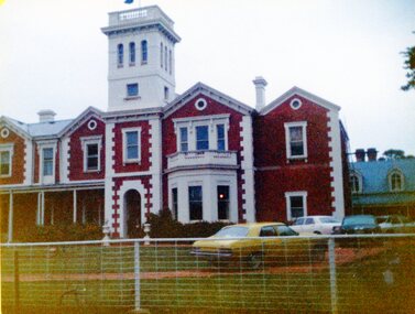
 Greensborough Historical Society
Letter - Correspondence, Banyule City Council, Viewbank Homestead Guided Tour Opportunity, 1998, 15/12/1998
Invitation from Banyule Cultural Services Officer to Jan Macdonald to participate in a guided tour and archaeological dig at Viewbank Homestead January, February and April 1999Comprises letter, with unbound information pamphlet and mapviewbank homestead, archaeological digs -
 Mt Dandenong & District Historical Society Inc.
Photograph
The photograph is from the album of Ivy Child and shows a view of one of the early homesteads in Kalorama. Ivy May Child (1910 – 1989) was the daughter of Arthur Edward (Ted) Child (1878 – 1964) and Ethel May Madden (1888 – 1970). Ted Child was the son of Matthew Francis Child (1839 – 1933) and Martha Jeeves (1857 – 1926). He was the grandson of one of the early pioneers Francis Child. Ivy grew up on the family property on Childs Road and took many photographs. Most of these are glued into her photo album. The album covered the years from c1927 – 1932. Ivy married Henry William Burgess (1906 – 1968) in 1944. The photographs remain in their original state in the album with individual copies made. Black and white photograph with a large trr in the centre beside a homestead with bush in the background.kalorama, homestead, ivy child -
 Stawell Historical Society Inc
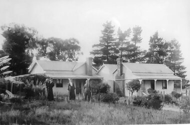
Photograph, “Swinton” Homestead in Glenorchy with alight pole and flagpole on the front lawn, 1913 approx
Black and white photo of “Swinton” Homestead Glenorchy with light pole and flagpole on front lawn. Swinton was a family name of John Carfrae whose father was Thomas Swinton Carfrae of Edinburgh. When John Carfrae came to Ledcourt in 1848 he divided it into three runs, Ledcourt - Swinton & Newington. Alexander Grey came to Swinton in 1881. The Grey Family still live at Swinton. After severe floods in 1909 the original homestead was destroyed. This home picture was built in 1911 on a site on higher grounds.B/W. Photograph: of a substantial house with five chimneys and verandah and Flagpole, in the mid distance is a light pole with a gas light, in the foreground is a tree. This photograph is a copy of a negative owned by the society. Paid with a grant 1991. this photograph is of the home at SWINTON Glenorchy. glenorchy -
 Sunbury Family History and Heritage Society Inc.
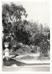
Photograph, 'Glenara' Homestead
The garden in the image was taken in the grounds of Glenara Homestead at Bulla, which was owned by Alister Clark of rose breeding fame. Refer to entry P0951 for the information relevant to the Clark family.A non-digital black and white photograph with a cream border of a large garden. A tower is seen in the distance and a pottery urn on a pedestal is to the LHS at the meeting of a pathway. -
 Stawell Historical Society Inc
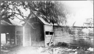
Photograph, "Ashen" Homestead Remnants in Murtoa after a Storm c1920’s
Dugald McPherson's Ashen's Homestead (Remnants) c1920’s Ashen's south of Murtoa was one of the area's original squatting runs. This photo taken in the 1920's shows the homestead after a violent storm had been through the area. In 1853, the country around Ashen's was covered by timber, she-oaks, bull-oaks, light gum and box thickets of ti-tree and clumps of pine and wattles. The vegetation was so thick outside the horse paddock it was difficult to move in any direction. It was said McPherson and two others fought over the land.Back entrance to Ashen's Station.stawell -
 Stawell Historical Society Inc
Photograph, “Overdale” Homestead in Concongella
“Overdale” Holden Homestead Concongella. James Holden settled on "Overdale" in the late 1860's. The Holden Family still live at "Overdale" The Holden Family have served on the Stawell Shire Council for over 100 years.Black and White enlarged photograph of house in file and small original photo in album. Building has prominent stone wall and trees around the house which has an inner timber and wire fence. Overdale sign on the stone wall.stawell -
 Eltham District Historical Society Inc
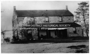
Photograph, "Pretty Hill", Kangaroo Ground. James Johnston's homestead
Kangaroo Ground pioneers James Johnston (died 1895) with his wife Elizabeth commenced building this stone house on his Pretty Hill property, Kangaroo Ground in 1842. It was one of the oldest homes in the district till 1938 when new owner Mr Percy Cope, a master builder demolished the old building and a new brick building was erected in its place. Pretty Hill is one of the highest spots in the district with splendid views of the surrounding country.This photo forms part of a collection of photographs gathered by the Shire of Eltham for their centenary project book,"Pioneers and Painters: 100 years of the Shire of Eltham" by Alan Marshall (1971). The collection of over 500 images is held in partnership between Eltham District Historical Society and Yarra Plenty Regional Library (Eltham Library) and is now formally known as 'The Shire of Eltham Pioneers Photograph Collection'. It is significant in being the first community sourced collection representing the places and people of the Shire's first one hundred years.Digital imagesepp, shire of eltham pioneers photograph collection, kangaroo ground, pretty hill, stonen house, homestead, johnston family, james johnston -
 Stawell Historical Society Inc
Photograph, "Mont Glen" Homestead - Watta Wella
Original "Mont Glen" homestead - Watta Wella. Bulit by Joh Blades Hall Senior - Located 300 metres behind "Lynleigh" (Home of grandson Collin Hall) - Later was the residence of his son Jahn Blades Hall Jnr.B/W Photo. Weathe board buildings , 2 chimneys, Pine trees behind. 3 Women in long dresses, 1 holding a child -
 Cheese World Museum
Photograph, Tooram Park homestead c1915, early 20th century
The Percy Uebergang family lived at Tooram Park, Allansford from 1912 until 1992. Percy and Myrtle Uebergang's children were twins, Ray and Joyce born in 1926 who lived at Tooram Park until their deaths, Ray in 1986 and Joyce in 1992. Neither Ray nor Joyce married and following the death of her brother Joyce set up the Ray and Joyce Uebergang Foundation which supports the local community. This photograph is part of the collection of items given into the care of the Cheese World Museum. The Uebergang family purchased Tooram Park in 1912. It was part of the original Tooram run which was taken up in 1839/40 by John McMahon Allan. Allan held the property until 1860 after which it passed through several owners including John Orlebar, Thomas McLeod Palmer, Owen family. Tooram was famous for the cheese from its large dairy herd. The herd was hand-milked. Palmer employed Indian labour to undertake this task. In 1883 Palmer was charged with the manslaughter of an Indian worker but was acquitted. This case was extensively reported in the Warrnambool Standard. The Standard also featured a number of articles about Tooram [22 June 1882, 17 March 1883 to 15 May 1993, 30 October 1886, 22 October 1897, 11 May 1926, 8 June 1931]. The property remained in the Uebergang family until after Joyce's death in 1992. Tooram is significant as it was one of the earliest runs taken up in the Warrnambool area. It was divided up following its sale in 1897. Tooram cheese was renowned. This photograph is significant as it shows Tooram Park homestead in its earlier days with the prolific timber decoration which was later removed.Black & white photograph on a cardboard mount showing Tooram Park homestead. The house has a white picket fence. A drain is in the foreground and is serviced by a stone culvert is in the right foreground. Two cars are parked in front of the house. The house walls are painted a dark colour. The verandah roof is striped dark and white. The timber decoration on the verandah, barge board and gable is white.allansford, tooram, tooram park, uebergang, john orlebar, john mcmahon allan, thomas mcleod palmer, owen family, indian labour, court cases, dairying, dairying, warrnambool standard -
 Wodonga & District Historical Society Inc
Album - Ringer's River by Des Martin - Plate 14 - O'Day visits the O'Hara's homestead
Daylight O'Day swims the river alone and, instead of going straight back to Gooloora, rides up-river a little to call at O'Hara's slab homestead where he is given a very warm welcome by young Erin O'Hara. Ellen Tenteye as Erin O'Hara.The album and images are significant because they document literature written by a prominent member of the Wodonga community. The presentation of this precis was supported by several significant district families and individuals.Ringer's River Album Coloured photo Plate 14des martin, many a mile, ringer's river, northeast victoria stories -
 Lake Bolac & District Historical Society
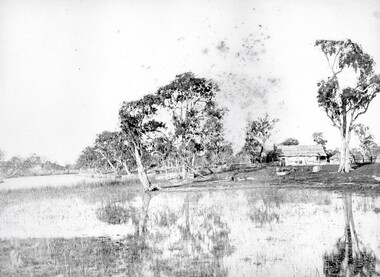
Black and white photograph, "Lake Boloke" homestead and the dry shore-line of Lake Bolac, circa 1855
A very early view of the first blue-stone homestead and out-buildings at "Lake Boloke" station, established by Robert Patterson, believed taken in the early 1850's. The row of River red-gums indicates the shoreline of Lake Bolac which seems to be at least partially dry.lake bolac, lake boloke station, patterson -
 Mt Dandenong & District Historical Society Inc.
Photograph
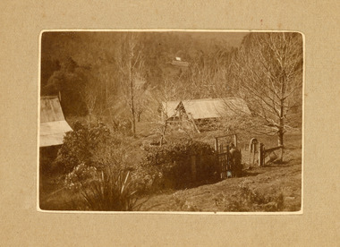
The photograph belonged to Frank Child and shows the homestead belonging to his grandparents Ted and Ethel Child situated on Childs Road at Kalorama. Francis Matthew (Frank) Child (1928 – 2020) was the son of Bernard Child (1907 – 1995). Bernard was the son of Ethel May Madden and an unknown father. When Ethel married Ted Child in 1908 Bernard was raised by Ted’s parents Francis and Martha Child. Bernard married Dulcie Paice (1904 – 1990) and they had one son, Frank Child, before they divorced in 1943.Small sepia photograph showing a woman entering the gateway to a homestead. The trees have lost their leaves and their are shrubs along the fence line. Two sheds can be seen to the right with a homestead roof to the left.Handwritten on reverse: Home of Ethel + Ted Child Childs Rd Kaloramafrank child, ted child, ethel child, childs road, kalorama, homestead -
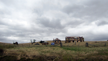
 Stawell Historical Society Inc
Photograph, Leadcourt Homestead
Leadcourt Homestead was built about 1868 by Mr. John Holt. Stone was transported from Mr Difficult. The Governor was entertained here in 1868 when he opened the Stawell Railway Station. One Sectionof the gable wing contained a bath large enough to swim in. 7115, 7115.1 Exterior of Ledcourt. 7115.2 Mrs Ethel Cooper facing lleft at the front entrance. 7119.3 View showing the office and rear of the homestead. 7114.4 Toilet block two section each able to seat two adults and one child at a time. 7115.5 Office Block. 7115.6: John Holt drowned in this dam in November 1876 in 10 feet of water. 7115.7 view of the grindstone ath the bace of an Oak tree. the bell was used to to call people to eat meals.A Group of 9 Colour Photos showing Leadcourt Homested. -
 Bacchus Marsh & District Historical Society
Photograph, Glenmore Homestead 1883
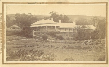
This homestead was built by Charles Griffith on a 55,000 acre Run. It replaced an earlier dwelling which was a slab hut with a bark roof. Charles Griffith, an Irish barrister, with his friend, James Moore, settled on Glenmore Station in the Parwan Valley in 1840. Their partnership lasted until 1848. In 1846, whilst in Ireland, Griffith married Miss Jane Catherine Magee, then returned to Glenmore and later took his nephew, Molesworth Richard Greene, into partnership, which arrangement proved to be long and prosperous. In 1857, they bought runs at Mount Hope and Mount Pyramid, which they kept until the days of free selection. Griffith led an active and successful public life.He was a member of the new Victorian Legislative Council in 1851, and was later an elected representative of the Legislative Assembly 1853-1859. He occupied many important public positions, including that of magistrate for Bacchus Marsh. Griffith was a devout Anglican and hosted Bishop Charles Perry at his station near Bacchus Marsh in 1849. He died in 1863 at his home in South Yarra.Small sepia unframed photograph on card with gold border framing photograph. Housed in the album, 'Photographs of Bacchus Marsh and District in 1883 by Stevenson and McNicoll'. The photograph shows a view of an extensive single-storey homestead consisting of three adjoining buildings, with a further building on the left of the main property. The series of three buildings is built in an elevated position, with pathways leading through a garden. At the front there is a vegetable garden which seems to be still in a state of development. The main house, possibly of brick, is set at an angle to the other two in this complex. It has a hip roof with a concave verandah on two sides with arched barge boards and simple unadorned pillars. There appears to be a hammock slung between two pillars. Two chimneys can be seen on this dwelling.The adjoining building is of a simpler design, with a lower roof line and a verandah running along the front. Two chimneys can be seen, one emitting smoke. This middle building may be a kitchen and rooms for day-to-day use. The third building is also of a simpler design, with a gable above a verandah. The purpose of this building is less clear. The different styles of construction suggest that these buildings were built separately at different times for different purposes. To the left of the main group of buildings is another cottage, smaller and of a simpler design. A fence runs along the front, clearly separating this building from the others, suggesting it may have been the dwelling of an overseer.On the front: Stevenson & McNicoll. Photo. 108 Elizabeth St. Melbourne. COPIES CAN BE OBTAINED AT ANY TIME. On the back: LIGHT & TRUTH inscribed on a banner surmounted by a representation of the rising sun. Copies of this Portrait can be had at any time by sending the Name and Post Office Money Order or Stamps for the amount of order to STEVENSON & McNICOLL LATE BENSON & STEVENSON, Photographers. 108 Elizabeth Street, MELBOURNE. stevenson and mcnicoll 1883 photographs of bacchus marsh and district, farms bacchus marsh, charles james griffith 1808-1863, glenmore station -
 Glenelg Shire Council Cultural Collection
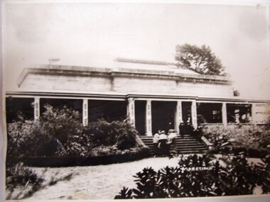
Photograph - Photograph - Maretimo, Portland, 1915
Photograph of Maretimo homesteadportland, homestead, maretimo -
 Ballarat Heritage Services
Digital photographs, L.J. Gervasoni, Gervasoni Homestead Yandoit Creek, 2012
http://vhd.heritagecouncil.vic.gov.au/places/69285 Digital imagesrestoration, heritage, swiss italian, gervasoni, homestead, family, yandoit creek, yandoit, pre restoration, complex -
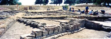 Greensborough Historical Society
Photograph - Photograph Collection, Jan Macdonald, Viewbank Homestead archaeological excavation 1999, 1999
In 1999, an archaeological dig was undertaken at the Viewbank Homestead site in Viewbank. This set of photographs was taken at the dig site in 1999. The house was built c1840 by James Williamson; it was later purchased by George Gear as a wedding gift to his daughter on her marriage to Dr Robert Martin. It became a grand mansion in the late 1800s but by the 1920s, it was stripped bare of materials and demolished in the 1920s. The archaeological dig was and insight into early life in the Viewbank HomesteadSet of 8 panoramic photos of archaeological dig and flyer for dig.viewbank homestead, banyule road viewbank, viewbank, archaeological digs -
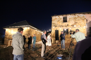 Ballarat Heritage Services
Digital photographs, L.J. Gervasoni, Restoration Australia Filming Gervasoni Homestead Yandoit Creek, 2015
http://vhd.heritagecouncil.vic.gov.au/places/69285 Digital imagesabc, restoration australia, filming, television, program, restoration, heritage, swiss italian, gervasoni, homestead, family -
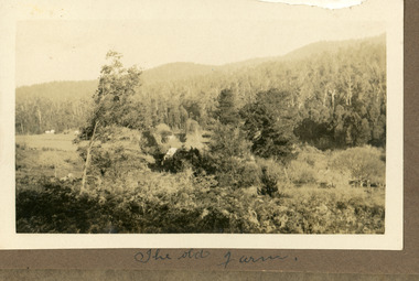 Mt Dandenong & District Historical Society Inc.
Photograph
The photograph is from the album of Ivy Child. The Old Farm could refer to the early homestead of her grandfather Matthew Francis Child. Ivy May Child (1910 – 1989) was the daughter of Arthur Edward (Ted) Child (1878 – 1964) and Ethel May Madden (1888 – 1970). Ted Child was the son of Matthew Francis Child (1839 – 1933) and Martha Jeeves (1857 – 1926). He was the grandson of one of the early pioneers Francis Child. Ivy grew up on the family property on Childs Road and took many photographs. Most of these are glued into her photo album. The album covered the years from c1927 – 1932. Ivy married Henry William Burgess (1906 – 1968) in 1944. The photographs remain in their original state in the album with individual copies made. Black and white photograph with a homestead in the centre surrounded by trees with hills and bushland in the background.Written below the photograph in album: The Old Farmfarm, ivy child, child family, homestead, kalorama -
 Ballarat Heritage Services
Digital photographs, L.J. Gervasoni, Gervasoni Homestead Yandoit Creek night, 2015
http://vhd.heritagecouncil.vic.gov.au/places/69285 Digital imagesrestoration, heritage, swiss italian, gervasoni, homestead, family, yandoit creek, yandoit, temporary, shed, permit exemption, concrete slab -
 Mt Dandenong & District Historical Society Inc.
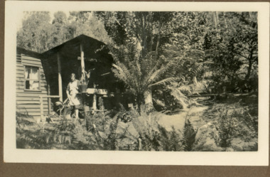
Photograph
The photograph is from the album of Ivy Child. The woman standing on the veranda is her mother Ethel Child (nee Madden). The homestead is on Childs Road and belonged to Ted and Ethel Child. Ivy May Child (1910 – 1989) was the daughter of Arthur Edward (Ted) Child (1878 – 1964) and Ethel May Madden (1888 – 1970). Ted Child was the son of Matthew Francis Child (1839 – 1933) and Martha Jeeves (1857 – 1926). He was the grandson of one of the early pioneers Francis Child. Ivy grew up on the family property on Childs Road and took many photographs. Most of these are glued into her photo album. The album covered the years from c1927 – 1932. Ivy married Henry William Burgess (1906 – 1968) in 1944. The photographs remain in their original state in the album with individual copies made. Black and white photograph showing a woman wearing an apron standing on the veranda of a wooden homestead. Ferns are in the foreground and around the building.ethel child, ted child, homestead, childs road -
 Lakes Entrance Historical Society
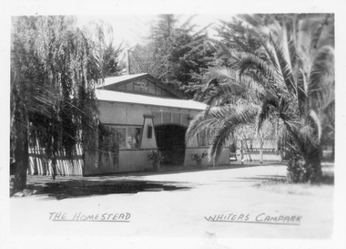
Postcard - Whiters Camp Park, Bulmer H D, 1945c
One of a set of eight small format postcardsBlack and white small format postcard of the Homestead at Whiters Camp Park. A fibro cement sheet clad residence of the proprietors family, palm tree at the right hand side. Lakes Entrance VictoriaThe Homestead, Whiters Camp Parkresort, recreation, tourism -
 Eltham District Historical Society Inc
Photograph, Fay Bridge, Rosehill Homestead, EDHS Heritage Excursion, 6 July 2019
July Excursion July 6, 2019 - Exploring Lower Plenty The predominant feature of this walk in the Bonds Road area, Lower Plenty is the large number of magnificent old River Red Gums that line the route. These trees are of the spreading woodland form of this species indicating that they must have been originally growing in a reasonably open setting. The walk also includes parts of the historic Cleveland Estate and the homestead “Rosehill” established by pioneer farmer Henry Stooke. This area was the site of the first recorded European settlement in what was to become the Shire of Eltham when the Willis brothers arrived in the late 1830s. From the southern part of Cleveland Avenue there are extensive views across and along the Yarra Valley. An article on the history of this area was contained in Newsletter edition 201, November 2011. The walk will start at the at the corner of Bonds and Stawell Roads, Lower Plenty - EDHS Newsletter No. 246 June 2019fay bridge collection, 2019-07-06, blackburn bricks, eltham district historical society, heritage excursion, rosehill homestead, lower plenty -
 Stawell Historical Society Inc
Photograph, "Schoolers" Homestead at Lake Lonsdale 1866
Schoolers Homestead Lake Lonsdale. Part of a collection of Photographs by Mr. O.G. Armstrong as commissioned by the Shire of Stawell for the Inter-colonial and Paris Exhibition in Melbourne in 1866. Similar Photo Scoullar station Rosehill Cat No 3888 G.F. Scoullar originally from Canada, according to W.G. Sharply in his 1930 Stawell Borough History, was a member of the Stawell Shire Council 1870-1888 and president 1875-1876. Maynard Ord in Stawell Past and Present says G.F. Scoullar, M. Brinkman and one other, took up small pieces of land fronting Lake Lonsdale. The owners of the Squatting Run, presumably Ledcourt, charged them with illegal occupation. They were heavily fined at Pleasant Creek Court, or in default gaol. As they could not afford the fine, some friends raise the money. Note re the spelling of ‘Schooler’. Variations in local records are ‘Schoullar’ and ‘Scoullar’. stawell education -
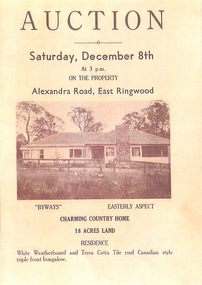 Ringwood and District Historical Society
Memorabilia - History Timeline, Byways Homestead, Coolooli Estate, Ringwood East, 1878-2008
Development of Coolooli Estate with property titles and leaflets for the sale of "Byways" homestead, 4 Byways Drive, Ringwood East. Also the house at 9 Walhalla Drive, Ringwood East. Correspondence between David Best and Richard Carter re the estate. Coolooli subdivision includes lots fronting Isabel Avenue, Byways Drive, Coolooli Court, Walhalla Drive and Cleland Street. Property Titleholders include: George Blood William Chelman Thurgood Frederick Deine Laurie Arthur Wigley Charles Patterson Mary Aphra Patterson John Douse Langley August DiGilio Kenneth Ross Landy Mervyn MacPherson Brewer Richard Blennenhassett Best Jessie May Cleland John Brian Little Robert William Campbell Lynette Marie Campbell Lorraine Ruby Campbell David Charles Nicholls Barbara Janette Nicholls Ian Finlay Packer Nellie Packer -
 Mt Dandenong & District Historical Society Inc.
Photograph
The photograph is from the album of Ivy Child. The homestead depicted belongs to Ivy's parents Ted and Ethel Child. It was part of the Child Family land at Kalorama. Ivy May Child (1910 – 1989) was the daughter of Arthur Edward (Ted) Child (1878 – 1964) and Ethel May Madden (1888 – 1970). Ted Child was the son of Matthew Francis Child (1839 – 1933) and Martha Jeeves (1857 – 1926). He was the grandson of one of the early pioneers Francis Child. Ivy grew up on the family property on Childs Road and took many photographs. Most of these are glued into her photo album. The album covered the years from c1927 – 1932. Ivy married Henry William Burgess (1906 – 1968) in 1944. The photographs remain in their original state in the album with individual copies made. Black and white photograph showing two women wearing sun hats and dresses walking down a pathway to the gate of a homestead.ivy child, ted child, ethel child, homestead, kalorama, child -
 Buninyong & District Historical Society
Photograph - Mount Buninyong Homestead front view, View showing part of the homestead of Mount Buninyong Homestead taken by an unknown photographer in 1991, 1991
House built by the Sott Family in 1884.Good condition, showing clear details of the buildingNonehistoric homestead, scott family, scotsburn. -
 Mt Dandenong & District Historical Society Inc.
Photograph
The photograph is from the album of Ivy Child. The original black and white photograph is also in the album. The homestead shown belonged to Ivy's parents Ted and Ethel Child. Ivy May Child (1910 – 1989) was the daughter of Arthur Edward (Ted) Child (1878 – 1964) and Ethel May Madden (1888 – 1970). Ted Child was the son of Matthew Francis Child (1839 – 1933) and Martha Jeeves (1857 – 1926). He was the grandson of one of the early pioneers Francis Child. Ivy grew up on the family property on Childs Road and took many photographs. Most of these are glued into her photo album. The album covered the years from c1927 – 1932. Ivy married Henry William Burgess (1906 – 1968) in 1944. The photographs remain in their original state in the album with individual copies made. A black and white photograph that has been coloured. It shows a scene of a homestead with a post and wire fence at the front and tress beside it. Hills can be seen in the distance.homestead, ivy child, ted child, ethel child, kalorama -
 Ballarat Heritage Services
Photograph, Clare Gervasoni, Brookside Farm Looking Towards the Creek, 21/01/2021
A video of Brookside Homestead looking towards the Creek, taken from the public roadway.brookside, farm, homestead