Showing 414 items matching " north kew"
-
 Kew Historical Society Inc
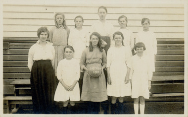
Photograph - Kew East Primary School, 1919
State School No. 3161 was originally situated between High Street (then Bulleen Road) and Kilby Road adjacent to Burke Road and was officially opened on 25th April 1892 with Mr Roland Gray as its Headmaster. With more people moving into the district, the School was moved in 1905 to Strathalbyn Street. (This site was to became the Kew East Bowling Club, and is now a Kindergarten.) 1929 saw the erection of the brick Infant School adjacent to the main building. In subsequent years many other buildings were added, including a weatherboard ‘Rural’ school, a brick library, an administration block, several portables, and a Community Music Centre and shelter sheds, culminating in the opening in March 2011 of the Commonwealth funded new Music/Sports Complex. At one time it was called Kew East Central School and included years 7 & 8. When Kew High School started, the high school students were accommodated there whilst their buildings were being completed.Original print positive, mounted on board of a co-educational class of students at Kew East 'Country School'. The Age newspaper on 6 March 1906 included in News of the Day that: "At a meeting of the Executive Council yesterday it was decided to proclaim the following State schools as training schools under the provisions of the Teachers' Act: Brunswick 1213; Queensberry-street, Carlton 2365; Kew East 3161; and Queensberry-street, North Melbourne 307. These schools have been specially selected and staffed in order that teachers in training and junior teachers may study the methods of the best teachers in special kinds of work. The infant class is the special feature at Brunswick, while Kew East will be a model of the methods of a country school. The schools at Queensberry-street, North Carlton and North Melbourne, are to be more especially connected with the training college."Obverse: Written on chalk slate - "Kew East / 3161 / Country School /19??"kew east primary school, margery canham, margery nickell, elizabeth angel, kew east state school, kew east country school, erik nickell -
 Kew Historical Society Inc
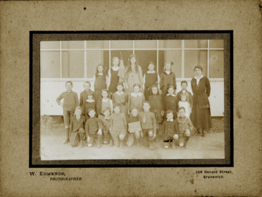
Photograph - Kew East State School
State School No. 3161 was originally situated between High Street (then Bulleen Road) and Kilby Road adjacent to Burke Road and was officially opened on 25th April 1892 with Mr Roland Gray as its Headmaster. With more people moving into the district, the School was moved in 1905 to Strathalbyn Street. (This site was to became the Kew East Bowling Club, and is now a Kindergarten.) 1929 saw the erection of the brick Infant School adjacent to the main building. In subsequent years many other buildings were added, including a weatherboard ‘Rural’ school, a brick library, an administration block, several portables, and a Community Music Centre and shelter sheds, culminating in the opening in March 2011 of the Commonwealth funded new Music/Sports Complex. At one time it was called Kew East Central School and included years 7 & 8. When Kew High School started, the high school students were accommodated there whilst their buildings were being completed.Original print positive of a co-educational class of students at Kew East State School. Howard Nickell is identified in an inscription on the reverse of the mount. The Age newspaper on 6 March 1906 included in News of the Day that: "At a meeting of the Executive Council yesterday it was decided to proclaim the following State schools as training schools under the provisions of the Teachers' Act: Brunswick 1213; Queensberry-street, Carlton 2365; Kew East 3161; and Queensberry-street, North Melbourne 307. These schools have been specially selected and staffed in order that teachers in training and junior teachers may study the methods of the best teachers in special kinds of work. The infant class is the special feature at Brunswick, while Kew East will be a model of the methods of a country school. The schools at Queensberry-street, North Carlton and North Melbourne, are to be more especially connected with the training college."Reverse: "Howard Nickell. Back Row. Second right."kew east primary school, elizabeth angel, kew east state school, howard nickell -
 Kew Historical Society Inc
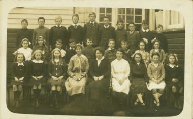
Photograph - Kew East State School
State School No. 3161 was originally situated between High Street (then Bulleen Road) and Kilby Road adjacent to Burke Road and was officially opened on 25th April 1892 with Mr Roland Gray as its Headmaster. With more people moving into the district, the School was moved in 1905 to Strathalbyn Street. (This site was to became the Kew East Bowling Club, and is now a Kindergarten.) 1929 saw the erection of the brick Infant School adjacent to the main building. In subsequent years many other buildings were added, including a weatherboard ‘Rural’ school, a brick library, an administration block, several portables, and a Community Music Centre and shelter sheds, culminating in the opening in March 2011 of the Commonwealth funded new Music/Sports Complex. At one time it was called Kew East Central School and included years 7 & 8. When Kew High School started, the high school students were accommodated there whilst their buildings were being completed.Original print positive, mounted on board of a co-educational class of students at Kew East State School. Jean Nickell is identified in an inscription on the reverse of the mount. The Age newspaper on 6 March 1906 included in News of the Day that: "At a meeting of the Executive Council yesterday it was decided to proclaim the following State schools as training schools under the provisions of the Teachers' Act: Brunswick 1213; Queensberry-street, Carlton 2365; Kew East 3161; and Queensberry-street, North Melbourne 307. These schools have been specially selected and staffed in order that teachers in training and junior teachers may study the methods of the best teachers in special kinds of work. The infant class is the special feature at Brunswick, while Kew East will be a model of the methods of a country school. The schools at Queensberry-street, North Carlton and North Melbourne, are to be more especially connected with the training college."Obverse on chalkboard: "Kew East / 3161 / 1 & 2 Grades" / Reverse: "Jean Nickell. Back row 6th left"kew east primary school, elizabeth angel, kew east state school, jean nickell, w edmends -
 Kew Historical Society Inc
Photograph - Kew East State School, 1926
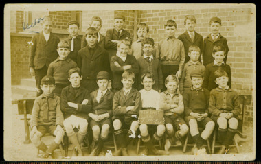
State School No. 3161 was originally situated between High Street (then Bulleen Road) and Kilby Road adjacent to Burke Road and was officially opened on 25th April 1892 with Mr Roland Gray as its Headmaster. With more people moving into the district, the School was moved in 1905 to Strathalbyn Street. (This site was to became the Kew East Bowling Club, and is now a Kindergarten.) 1929 saw the erection of the brick Infant School adjacent to the main building. In subsequent years many other buildings were added, including a weatherboard ‘Rural’ school, a brick library, an administration block, several portables, and a Community Music Centre and shelter sheds, culminating in the opening in March 2011 of the Commonwealth funded new Music/Sports Complex. At one time it was called Kew East Central School and included years 7 & 8. When Kew High School started, the high school students were accommodated there whilst their buildings were being completed.Original print positive of class of boys at Kew East State School. Hector Canham is identified in an inscription on the reverse of the mount. The Age newspaper on 6 March 1906 included in News of the Day that: "At a meeting of the Executive Council yesterday it was decided to proclaim the following State schools as training schools under the provisions of the Teachers' Act: Brunswick 1213; Queensberry-street, Carlton 2365; Kew East 3161; and Queensberry-street, North Melbourne 307. These schools have been specially selected and staffed in order that teachers in training and junior teachers may study the methods of the best teachers in special kinds of work. The infant class is the special feature at Brunswick, while Kew East will be a model of the methods of a country school. The schools at Queensberry-street, North Carlton and North Melbourne, are to be more especially connected with the training college."Obverse : "Hector [arrowed]" / Reverse: "5th Grade. Hector Canham. Back row left."kew east primary school, elizabeth angel, kew east state school, hector canham -
 Kew Historical Society Inc
Photograph - Kew East State School
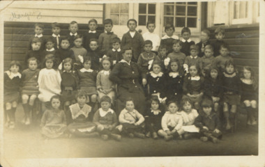
State School No. 3161 was originally situated between High Street (then Bulleen Road) and Kilby Road adjacent to Burke Road and was officially opened on 25th April 1892 with Mr Roland Gray as its Headmaster. With more people moving into the district, the School was moved in 1905 to Strathalbyn Street. (This site was to became the Kew East Bowling Club, and is now a Kindergarten.) 1929 saw the erection of the brick Infant School adjacent to the main building. In subsequent years many other buildings were added, including a weatherboard ‘Rural’ school, a brick library, an administration block, several portables, and a Community Music Centre and shelter sheds, culminating in the opening in March 2011 of the Commonwealth funded new Music/Sports Complex. At one time it was called Kew East Central School and included years 7 & 8. When Kew High School started, the high school students were accommodated there whilst their buildings were being completed.Original print positive of a co-educational class at Kew East State School. Margaret Nickell is identified in an inscription on the reverse of the mount. The Age newspaper on 6 March 1906 included in News of the Day that: "At a meeting of the Executive Council yesterday it was decided to proclaim the following State schools as training schools under the provisions of the Teachers' Act: Brunswick 1213; Queensberry-street, Carlton 2365; Kew East 3161; and Queensberry-street, North Melbourne 307. These schools have been specially selected and staffed in order that teachers in training and junior teachers may study the methods of the best teachers in special kinds of work. The infant class is the special feature at Brunswick, while Kew East will be a model of the methods of a country school. The schools at Queensberry-street, North Carlton and North Melbourne, are to be more especially connected with the training college."Obverse : "Margery [arrowed]" / Reverse: "Margery Nickell. 2nd row left end. Teacher Miss Grey."kew east primary school, elizabeth angel, kew east state school, margery nickell -
 Kew Historical Society Inc
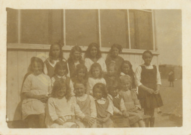
Photograph - Kew East State School, 1921-28
State School No. 3161 was originally situated between High Street (then Bulleen Road) and Kilby Road adjacent to Burke Road and was officially opened on 25th April 1892 with Mr Roland Gray as its Headmaster. With more people moving into the district, the School was moved in 1905 to Strathalbyn Street. (This site was to became the Kew East Bowling Club, and is now a Kindergarten.) 1929 saw the erection of the brick Infant School adjacent to the main building. In subsequent years many other buildings were added, including a weatherboard ‘Rural’ school, a brick library, an administration block, several portables, and a Community Music Centre and shelter sheds, culminating in the opening in March 2011 of the Commonwealth funded new Music/Sports Complex. At one time it was called Kew East Central School and included years 7 & 8. When Kew High School started, the high school students were accommodated there whilst their buildings were being completed.Original print positive of a class of girls at Kew East State School. The Age newspaper on 6 March 1906 included in News of the Day that: "At a meeting of the Executive Council yesterday it was decided to proclaim the following State schools as training schools under the provisions of the Teachers' Act: Brunswick 1213; Queensberry-street, Carlton 2365; Kew East 3161; and Queensberry-street, North Melbourne 307. These schools have been specially selected and staffed in order that teachers in training and junior teachers may study the methods of the best teachers in special kinds of work. The infant class is the special feature at Brunswick, while Kew East will be a model of the methods of a country school. The schools at Queensberry-street, North Carlton and North Melbourne, are to be more especially connected with the training college."Obverse : "East Kew 1921 [sic] / Reverse: "East Kew 1928 [sic]"kew east primary school, elizabeth angel, kew east state school -
 Kew Historical Society Inc
Photograph - Kew East State School
State School No. 3161 was originally situated between High Street (then Bulleen Road) and Kilby Road adjacent to Burke Road and was officially opened on 25th April 1892 with Mr Roland Gray as its Headmaster. With more people moving into the district, the School was moved in 1905 to Strathalbyn Street. (This site was to became the Kew East Bowling Club, and is now a Kindergarten.) 1929 saw the erection of the brick Infant School adjacent to the main building. In subsequent years many other buildings were added, including a weatherboard ‘Rural’ school, a brick library, an administration block, several portables, and a Community Music Centre and shelter sheds, culminating in the opening in March 2011 of the Commonwealth funded new Music/Sports Complex. At one time it was called Kew East Central School and included years 7 & 8. When Kew High School started, the high school students were accommodated there whilst their buildings were being completed.Original print positive of a class of girls at what is believed to be Kew East State School. The Age newspaper on 6 March 1906 included in News of the Day that: "At a meeting of the Executive Council yesterday it was decided to proclaim the following State schools as training schools under the provisions of the Teachers' Act: Brunswick 1213; Queensberry-street, Carlton 2365; Kew East 3161; and Queensberry-street, North Melbourne 307. These schools have been specially selected and staffed in order that teachers in training and junior teachers may study the methods of the best teachers in special kinds of work. The infant class is the special feature at Brunswick, while Kew East will be a model of the methods of a country school. The schools at Queensberry-street, North Carlton and North Melbourne, are to be more especially connected with the training college."Reverse : "Margery Nickell. 2nd row, 2nd left"kew east primary school, elizabeth angel, kew east state school, margery nickell -
 Kew Historical Society Inc
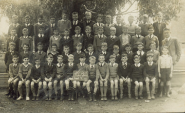
Photograph - Kew East Central School, c.1911
State School No. 3161 was originally situated between High Street (then Bulleen Road) and Kilby Road adjacent to Burke Road and was officially opened on 25th April 1892 with Mr Roland Gray as its Headmaster. With more people moving into the district, the School was moved in 1905 to Strathalbyn Street. (This site was to became the Kew East Bowling Club, and is now a Kindergarten.) 1929 saw the erection of the brick Infant School adjacent to the main building. In subsequent years many other buildings were added, including a weatherboard ‘Rural’ school, a brick library, an administration block, several portables, and a Community Music Centre and shelter sheds, culminating in the opening in March 2011 of the Commonwealth funded new Music/Sports Complex. At one time it was called Kew East Central School and included years 7 & 8. When Kew High School started, the high school students were accommodated there whilst their buildings were being completed.Original print positive of a class of boys at Kew East Central School. The Age newspaper on 6 March 1906 included in News of the Day that: "At a meeting of the Executive Council yesterday it was decided to proclaim the following State schools as training schools under the provisions of the Teachers' Act: Brunswick 1213; Queensberry-street, Carlton 2365; Kew East 3161; and Queensberry-street, North Melbourne 307. These schools have been specially selected and staffed in order that teachers in training and junior teachers may study the methods of the best teachers in special kinds of work. The infant class is the special feature at Brunswick, while Kew East will be a model of the methods of a country school. The schools at Queensberry-street, North Carlton and North Melbourne, are to be more especially connected with the training college."Obverse: on chalkboard - "East Kew Central School, Grade 5. 1911 [sic]". kew east primary school, elizabeth angel, kew east state school, kew east central school -
 Kew Historical Society Inc
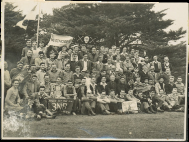
Photograph - Assembled community groups
... Kew Historical Society Inc 1 Civic Drive Kew melbourne ...Large, group photo comprised of men and boys, representing different groups, including one at front left holding a community radio banner 3NB North Balwyn - 'Never Off The Air: 3NB North Balwyn'. Other [legible] banners read: 'Glenbervie: the Bears', 'Brighton', 'Black Shirts', 'Westmores'.glenberve, 3nb north balwyn -
 Kew Historical Society Inc
Book, Rosalie Triolo, Our Schools and the War, 2012
"The Great War profoundly touched the lives of Australian teachers, school children and local communities, and with lasting consequences. Every teacher had the task of explaining the war to their students. Many teachers, a disproportionately large number, fought and died, and were joined by their older students. For years after, the names of those who fell were respectfully displayed on school honor boards, in honor books and remembered by other commemorative means, including through the introduction of Anzac Day. How teachers and school communities were affected by patriotic appeals and activities, and how they responded to the long years of grim news from Gallipoli, the Western Front and other sites of training, fighting and convalescence, is revealed in an account that historians, general readers and today's students will find illuminating and deeply moving." --Back cover.North Melbourne, Vic. : Australian Scholarly Publishing, 2012 : xvii, 364 pages : illustrations, facsimiles, portraits ; 25 cm non-fiction"The Great War profoundly touched the lives of Australian teachers, school children and local communities, and with lasting consequences. Every teacher had the task of explaining the war to their students. Many teachers, a disproportionately large number, fought and died, and were joined by their older students. For years after, the names of those who fell were respectfully displayed on school honor boards, in honor books and remembered by other commemorative means, including through the introduction of Anzac Day. How teachers and school communities were affected by patriotic appeals and activities, and how they responded to the long years of grim news from Gallipoli, the Western Front and other sites of training, fighting and convalescence, is revealed in an account that historians, general readers and today's students will find illuminating and deeply moving." --Back cover.ww1, first world war, schools, education, wwi -
 Kew Historical Society Inc
Journal, Kewriosity : August 1992
... . Pictures of Kew [New Trinity Grammar classrooms; North kew Tennis ...Kew Traffic School / p1. New Mayor for Kew [Cr Roger Streeton] / p1. Kindergarten open days / p1. Chief Executive's Column [Changes happening in Kew; Waste Management Strategy; Pakington Street Kindergarten and Maternal & Child Health Centre; New tennis and scout facility; Harp Junction works / Outer Circle Rail Reserve; Construction of new postal sorting facility for Kew] / Malcolm Hutchinson p2&3. Mayor's Comment / Cr Roger Streeton] / p3. Diary dates for August/Septemvber [1992] / p4. Young Achiever Awards / p4. Concerned about possums / p5. Medicine / p5. Music for children / p6. Cinders! [Track Players Children's Workshop] / p5. In Brief [Community radio for a 'tuned-in' community; Camberwell Music Society; Kew Philharmonic Society; Mega mushroom; Have you got a parking permit?; Free legal advice; Kew Croquet Club's 60th Birthday year; Do you worry about the air you breather?; Kew East Primary School Centenary celebrations / p7. Pictures of Kew [New Trinity Grammar classrooms; North kew Tennis Club and Scout Hall; Mrs Helen Telford, Head of Carey Grammar Junior School; North Kew Maternal & Child Health Centre] / p8. Be in the movies / p8.Kewriosity was a local newsletter combining Kew Council and community news. It was published between November 1983 and June 1994, replacing an earlier Kewriosity [broad] Sheet (1979-84). In producing Kewriosity, Council aimed to provide a range of interesting and informative articles covering its deliberations and decision making, together with items of general interest and importance to the Kew community and information not generally available through daily media outlets.non-fictionKew Traffic School / p1. New Mayor for Kew [Cr Roger Streeton] / p1. Kindergarten open days / p1. Chief Executive's Column [Changes happening in Kew; Waste Management Strategy; Pakington Street Kindergarten and Maternal & Child Health Centre; New tennis and scout facility; Harp Junction works / Outer Circle Rail Reserve; Construction of new postal sorting facility for Kew] / Malcolm Hutchinson p2&3. Mayor's Comment / Cr Roger Streeton] / p3. Diary dates for August/Septemvber [1992] / p4. Young Achiever Awards / p4. Concerned about possums / p5. Medicine / p5. Music for children / p6. Cinders! [Track Players Children's Workshop] / p5. In Brief [Community radio for a 'tuned-in' community; Camberwell Music Society; Kew Philharmonic Society; Mega mushroom; Have you got a parking permit?; Free legal advice; Kew Croquet Club's 60th Birthday year; Do you worry about the air you breather?; Kew East Primary School Centenary celebrations / p7. Pictures of Kew [New Trinity Grammar classrooms; North kew Tennis Club and Scout Hall; Mrs Helen Telford, Head of Carey Grammar Junior School; North Kew Maternal & Child Health Centre] / p8. Be in the movies / p8.publications -- city of kew (vic.), kewriosity, council newsletters, community newsletters -
Kew Historical Society Inc
Journal, Kewriosity : May 1992
... Care Centre Denmark Street; North Kew Tennis Club; Kew Band ...Strategic bicycle plan / p1. World No Tobacco Day / p1. Chief Executive's Column [New approach to rates and charges] / Malcolm Hutchinson p2. Mayor's Comment [New Accounting Standard for Local Government; A living history of Kew] / Cr Daryl Oldaker. Diary Dates for May/June [1992] / p4. In Brief [Volunteers - Kew Cottages & Uniting Church Lodge; Maternal and Child Care Centre Denmark Street; North Kew Tennis Club; Kew Band; Kew Senior Citizens' Club; Schizophrenia Fellowship; Kew Bowling Club; Recycling; Life Education Centre; Baptist Church] / p5. St George's Hospital Redevelopment Plan / p6. Kindergarten enrolments / p6. What is a Neighbourhood House? / p6. Planning for optimum community health, municipal public health plans [Schizophrenia; Reading mobility] / p7. Trees v Power Lines / p8. Weed control / p8. 90th Birthday Trinity Grammar / New swimming pool for Carey Grammar / p8.Kewriosity was a local newsletter combining Kew Council and community news. It was published between November 1983 and June 1994, replacing an earlier Kewriosity [broad] Sheet (1979-84). In producing Kewriosity, Council aimed to provide a range of interesting and informative articles covering its deliberations and decision making, together with items of general interest and importance to the Kew community and information not generally available through daily media outlets.non-fictionStrategic bicycle plan / p1. World No Tobacco Day / p1. Chief Executive's Column [New approach to rates and charges] / Malcolm Hutchinson p2. Mayor's Comment [New Accounting Standard for Local Government; A living history of Kew] / Cr Daryl Oldaker. Diary Dates for May/June [1992] / p4. In Brief [Volunteers - Kew Cottages & Uniting Church Lodge; Maternal and Child Care Centre Denmark Street; North Kew Tennis Club; Kew Band; Kew Senior Citizens' Club; Schizophrenia Fellowship; Kew Bowling Club; Recycling; Life Education Centre; Baptist Church] / p5. St George's Hospital Redevelopment Plan / p6. Kindergarten enrolments / p6. What is a Neighbourhood House? / p6. Planning for optimum community health, municipal public health plans [Schizophrenia; Reading mobility] / p7. Trees v Power Lines / p8. Weed control / p8. 90th Birthday Trinity Grammar / New swimming pool for Carey Grammar / p8.publications -- city of kew (vic.), kewriosity, council newsletters, community newsletters -
Kew Historical Society Inc
Journal, Kewriosity : March 1992
Kew Festival Special Edition [16pp] / p1. Looking for deregulation in North America / Janet Dore p2&3. Mayor's Comment / Cr Daryl Oldaker p3. New Parking signs / p4. Disabled parking permits / p5. Long term parking p5. Girl Guides & Brownie Guides of Kew / p5. Anyone for tennis? [East Kew Uniting Church] / p5. Football in Kew / p5. New Principal at Hew High School [Alan Taylor] / p6. Trinity Grammar Open Day / p6. Youth Leadership Course / p7. Caritas Christi Hospice Awareness Week / p7. Kew Youth Arts Festival [programme of events] / pp8-9. Diary Dates for March [1992] / p10. Kew Festival Concert at Holy Trinity / p10. Direct Line 2 [Kew Cottages] / p11. Kew Recreation Centre 383-407 High Street, Kew / p11. Healthy fun activities / p11. Free bike identification / p12. Feet feature / p12. New courses at Kew Community House / p13. Kew Junction Commercial Centre / p14. Fundraisers extraordinaire [St. George’s Hospital Kew Ladies’ Auxiliary] / p14. Vale - John Hogan Gervasoni J.P. 1929-1992 / p15. Draft Gaming Machine Policy / p15. Revealing Villa Alba - Open Days / p16.Kewriosity was a local newsletter combining Kew Council and community news. It was published between November 1983 and June 1994, replacing an earlier Kewriosity [broad] Sheet (1979-84). In producing Kewriosity, Council aimed to provide a range of interesting and informative articles covering its deliberations and decision making, together with items of general interest and importance to the Kew community and information not generally available through daily media outlets.non-fictionKew Festival Special Edition [16pp] / p1. Looking for deregulation in North America / Janet Dore p2&3. Mayor's Comment / Cr Daryl Oldaker p3. New Parking signs / p4. Disabled parking permits / p5. Long term parking p5. Girl Guides & Brownie Guides of Kew / p5. Anyone for tennis? [East Kew Uniting Church] / p5. Football in Kew / p5. New Principal at Hew High School [Alan Taylor] / p6. Trinity Grammar Open Day / p6. Youth Leadership Course / p7. Caritas Christi Hospice Awareness Week / p7. Kew Youth Arts Festival [programme of events] / pp8-9. Diary Dates for March [1992] / p10. Kew Festival Concert at Holy Trinity / p10. Direct Line 2 [Kew Cottages] / p11. Kew Recreation Centre 383-407 High Street, Kew / p11. Healthy fun activities / p11. Free bike identification / p12. Feet feature / p12. New courses at Kew Community House / p13. Kew Junction Commercial Centre / p14. Fundraisers extraordinaire [St. George’s Hospital Kew Ladies’ Auxiliary] / p14. Vale - John Hogan Gervasoni J.P. 1929-1992 / p15. Draft Gaming Machine Policy / p15. Revealing Villa Alba - Open Days / p16.publications -- city of kew (vic.), kewriosity, council newsletters, community newsletters -
Kew Historical Society Inc
Journal, Kewriosity : June 1991
... community newsletters Re locations [North Kew Tennis Club, 1st Kew ...Re locations [North Kew Tennis Club, 1st Kew Scouts] / 1. North's replacement kinder [Kew Preschool Association and North Kew Kindergarten in Pakington Street] / p1. Kinders - What to do? [Council finances] / p1. Junction Traffic Study / p1. Diary dates for June / p2. Bravo, Band! [Kew Youth Band, Kew Band] / p2. World's best animation [3 MBS fundraising] / p2. Travelling friends [St Anthony's Children's Home reunion] / p2. Commentary [Council budget] / Cr Daryl Oldaker p3. Chief Executive's Column [corporate structure] / Malcolm Hutchinson p3. Beat the beetle [elm leaf beetle] / p4. One electorate: six winners [Hare Clark system] / p4. Heritage Planning [Heritage Residential Zone and individual building controls] / p4. Vale - Allan Hutchinson J.P. 1938-1991 [obituary] / p4. Kewriosity lives on / p5. Nappies in Walpole Street [baby change room] / p6. St George's not dragg'n its feet [Three Year Accreditation Certificate] / p6. Get a dog ... But register it / p6. Sisters kick up heels [Our Lady of Missions dance] / p6. Davis Street's open day [Davis Street Kindergarten] / p7. Baby, Look at us now [High Street Kindergarten] / p6. [Fourth Kew] Scouts host Chernobyl children / p6. New threesome [Trio Nova] / p7. A good get-together [Kew Community House] / p7. A certain timbre [furniture design] / 7. Pride on wheels / p7. Keeping home fires burning [Dunnings Wood Yard] / p7. 1938 diarists / p8. Carey picnic / p8. Henry VIII Birthday / p8. Walk the Outer Circle [walking tours by Australian Railway Historical Society] / p8.Kewriosity was a local newsletter combining Kew Council and community news. It was published between November 1983 and June 1994, replacing an earlier Kewriosity [broad] Sheet (1979-84). In producing Kewriosity, Council aimed to provide a range of interesting and informative articles covering its deliberations and decision making, together with items of general interest and importance to the Kew community and information not generally available through daily media outlets.non-fictionRe locations [North Kew Tennis Club, 1st Kew Scouts] / 1. North's replacement kinder [Kew Preschool Association and North Kew Kindergarten in Pakington Street] / p1. Kinders - What to do? [Council finances] / p1. Junction Traffic Study / p1. Diary dates for June / p2. Bravo, Band! [Kew Youth Band, Kew Band] / p2. World's best animation [3 MBS fundraising] / p2. Travelling friends [St Anthony's Children's Home reunion] / p2. Commentary [Council budget] / Cr Daryl Oldaker p3. Chief Executive's Column [corporate structure] / Malcolm Hutchinson p3. Beat the beetle [elm leaf beetle] / p4. One electorate: six winners [Hare Clark system] / p4. Heritage Planning [Heritage Residential Zone and individual building controls] / p4. Vale - Allan Hutchinson J.P. 1938-1991 [obituary] / p4. Kewriosity lives on / p5. Nappies in Walpole Street [baby change room] / p6. St George's not dragg'n its feet [Three Year Accreditation Certificate] / p6. Get a dog ... But register it / p6. Sisters kick up heels [Our Lady of Missions dance] / p6. Davis Street's open day [Davis Street Kindergarten] / p7. Baby, Look at us now [High Street Kindergarten] / p6. [Fourth Kew] Scouts host Chernobyl children / p6. New threesome [Trio Nova] / p7. A good get-together [Kew Community House] / p7. A certain timbre [furniture design] / 7. Pride on wheels / p7. Keeping home fires burning [Dunnings Wood Yard] / p7. 1938 diarists / p8. Carey picnic / p8. Henry VIII Birthday / p8. Walk the Outer Circle [walking tours by Australian Railway Historical Society] / p8. publications -- city of kew (vic.), kewriosity, council newsletters, community newsletters -
Kew Historical Society Inc
Journal, Kewriosity : July 1989
... Club, North Kew Football Club] / p6. Neighbourhood Watch / p6 ...Council elections on August 5 / p1. dates for July / p2. Recycling is the solution / p2. Commentary / Cr Allen Martin p3. Social isolation in Kew [Kew Community Action Group] / p3. Bridge duplication [Chandler Highway Bridge] / p3. Garbage review / p3. Notices / p4. Possums Playgroup / p4. Traffic update Area 10 / p4. Kew's/Hawthorn's CABs reduce hours [Citizens’ Advice Bureaux] / p4. Yarra Scenic Drive / p4. Theatre of the Deaf [MLC] / p4. Sale of other's treasures buys talking books [Friends of Kew Library] / p5. A rewarding career at home / p5. New children's vaccine [measles, mumps, rubella] / p5. First aid-course / p5. Kew Community House / p6. Traffic humps / p6. Greenlink Kew / p6. Jeff Fenech's gloves under the hammer [Kew Football Club, North Kew Football Club] / p6. Neighbourhood Watch / p6. 15 minute Hamlet [Toorak Players Teenage Workshop] / p7. Kane's Bridge work / p7. We like school [Sacred Heart School] / p7. Mayor hosts reception to say thanks to volunteers / p8. Letters to the editor [Neighbourhood Watch] / p8. Kew Band report / p8. Footy News [Kew Football Club] / p8.Kewriosity was a local newsletter combining Kew Council and community news. It was published between November 1983 and June 1994, replacing an earlier Kewriosity [broad] Sheet (1979-84). In producing Kewriosity, Council aimed to provide a range of interesting and informative articles covering its deliberations and decision making, together with items of general interest and importance to the Kew community and information not generally available through daily media outlets.non-fictionCouncil elections on August 5 / p1. dates for July / p2. Recycling is the solution / p2. Commentary / Cr Allen Martin p3. Social isolation in Kew [Kew Community Action Group] / p3. Bridge duplication [Chandler Highway Bridge] / p3. Garbage review / p3. Notices / p4. Possums Playgroup / p4. Traffic update Area 10 / p4. Kew's/Hawthorn's CABs reduce hours [Citizens’ Advice Bureaux] / p4. Yarra Scenic Drive / p4. Theatre of the Deaf [MLC] / p4. Sale of other's treasures buys talking books [Friends of Kew Library] / p5. A rewarding career at home / p5. New children's vaccine [measles, mumps, rubella] / p5. First aid-course / p5. Kew Community House / p6. Traffic humps / p6. Greenlink Kew / p6. Jeff Fenech's gloves under the hammer [Kew Football Club, North Kew Football Club] / p6. Neighbourhood Watch / p6. 15 minute Hamlet [Toorak Players Teenage Workshop] / p7. Kane's Bridge work / p7. We like school [Sacred Heart School] / p7. Mayor hosts reception to say thanks to volunteers / p8. Letters to the editor [Neighbourhood Watch] / p8. Kew Band report / p8. Footy News [Kew Football Club] / p8. publications -- city of kew (vic.), kewriosity, council newsletters, community newsletters -
Kew Historical Society Inc
Journal, Kewriosity : September 1988
... Keon-Cohen] / p3. Willsmere Forum / p3. Notices [North Kew ...Council urges 'YES' vote on September 3 [Constitutional recognition for local government]/ p1-2. Meet the Mayor [Cr Allen Martin] / p1. Dates for September / p2. Kew Living launch [Bicentennial project] / p2. Commentary / Cr Allen Martin p3. Amnesty on dogs [registration] / p3. Election results / p3. Former Kew Councillor for County Court [Judge Chester Keon-Cohen] / p3. Willsmere Forum / p3. Notices [North Kew Tennis Club] / p4. Community clean up [Boroondara Bushwalkers] / p4. Pregnancy support / p4. Teenage Disco [Youth Resource Centre] / p4. Friendship and fun at playgroup [Highbury Grove Playgroup]/ p4. Friends of Kew Library / p4. Christmas cards for Kew / p4. Kew group to perform at Spoleto Festival [Elysium Ensemble] / p5. Community celebrations at Kew High School [State Education Week] / p5. Kew Community House / Judy Price p6. Student help / p6. Used furniture - can you help? [Belford Oaks Full Day Care Centre] / p6. Keeping you informed [Kew Citizens’ Advice Bureau] / p6. [Kew] Community Directory [1989] p6. Fun, fitness and family [Kew Little Athletics Centre] / p7. Community recreation for disabled [ Kew Recreation Integration Support Group] / p7. Footy News [Kew Football Club] / p8. Bowls season starts soon [Kew Bowling Club] / p8. Cricket Club invites new members [Deepdene Uniting Cricket Club] / p8. Spring into Spring with volleyball [Kew High School Sports Centre] / p8. 1st Kew Scouts ready to expand / p8.Kewriosity was a local newsletter combining Kew Council and community news. It was published between November 1983 and June 1994, replacing an earlier Kewriosity [broad] Sheet (1979-84). In producing Kewriosity, Council aimed to provide a range of interesting and informative articles covering its deliberations and decision making, together with items of general interest and importance to the Kew community and information not generally available through daily media outlets.non-fictionCouncil urges 'YES' vote on September 3 [Constitutional recognition for local government]/ p1-2. Meet the Mayor [Cr Allen Martin] / p1. Dates for September / p2. Kew Living launch [Bicentennial project] / p2. Commentary / Cr Allen Martin p3. Amnesty on dogs [registration] / p3. Election results / p3. Former Kew Councillor for County Court [Judge Chester Keon-Cohen] / p3. Willsmere Forum / p3. Notices [North Kew Tennis Club] / p4. Community clean up [Boroondara Bushwalkers] / p4. Pregnancy support / p4. Teenage Disco [Youth Resource Centre] / p4. Friendship and fun at playgroup [Highbury Grove Playgroup]/ p4. Friends of Kew Library / p4. Christmas cards for Kew / p4. Kew group to perform at Spoleto Festival [Elysium Ensemble] / p5. Community celebrations at Kew High School [State Education Week] / p5. Kew Community House / Judy Price p6. Student help / p6. Used furniture - can you help? [Belford Oaks Full Day Care Centre] / p6. Keeping you informed [Kew Citizens’ Advice Bureau] / p6. [Kew] Community Directory [1989] p6. Fun, fitness and family [Kew Little Athletics Centre] / p7. Community recreation for disabled [ Kew Recreation Integration Support Group] / p7. Footy News [Kew Football Club] / p8. Bowls season starts soon [Kew Bowling Club] / p8. Cricket Club invites new members [Deepdene Uniting Cricket Club] / p8. Spring into Spring with volleyball [Kew High School Sports Centre] / p8. 1st Kew Scouts ready to expand / p8. publications -- city of kew (vic.), kewriosity, council newsletters, community newsletters -
Kew Historical Society Inc
Journal, Kew Historical Society, Newsletter No.106, March 2014
... , Greenacres Golf Club, North Kew Tennis Club; Sacred Heart Tennis Club ...Preserving our heritage [Sports in Kew] / Robert Baker p1-2. Society activities: Exhibitions [Sport in Kew]; 2014 McIntyre Lecture [Sir Gustav Nossal AC CBE]; Past Meetings; Future Meetings; New website / p3. Exhibition - Sport in Kew [Kew Croquet Club, Kew Golf Club, Greenacres Golf Club, North Kew Tennis Club; Sacred Heart Tennis Club] / p4-5. Letters to the editor [Tara Hall; Kew Flyer] / Dione McIntyre; Lindsay Goold p5. Scouting in Kew / Brad Miles p6-7. The MMBW Plans of Kew / Robert Baker p8. The Princess Hotel / Robert Baker p9-10. The Noble family of Kew / Judith Vimpani & Robert Baker p10. It happened in the past [150-years ago; 100-years ago; 50 years ago] / p11. Support Kew's history / p11. Mystery House / p12. Book sale / p12. Dates for your diary / p12.Published quarterly since 1977, the newsletters of the Kew Historical Society contain significant research by members exploring relevant aspects of the Victorian and Australian Framework of Historical Themes. Frequently, articles on people, places and artefacts are the only source of information about an aspect of Kew, and Melbourne’s history.non-fictionPreserving our heritage [Sports in Kew] / Robert Baker p1-2. Society activities: Exhibitions [Sport in Kew]; 2014 McIntyre Lecture [Sir Gustav Nossal AC CBE]; Past Meetings; Future Meetings; New website / p3. Exhibition - Sport in Kew [Kew Croquet Club, Kew Golf Club, Greenacres Golf Club, North Kew Tennis Club; Sacred Heart Tennis Club] / p4-5. Letters to the editor [Tara Hall; Kew Flyer] / Dione McIntyre; Lindsay Goold p5. Scouting in Kew / Brad Miles p6-7. The MMBW Plans of Kew / Robert Baker p8. The Princess Hotel / Robert Baker p9-10. The Noble family of Kew / Judith Vimpani & Robert Baker p10. It happened in the past [150-years ago; 100-years ago; 50 years ago] / p11. Support Kew's history / p11. Mystery House / p12. Book sale / p12. Dates for your diary / p12. kew historical society (vic.) -- periodicals., kew historical society (vic.) -- newsletters, kew historical society (vic.) -- journals -
Kew Historical Society Inc
Journal, Kewriosity : November 1987
... Foundation of Victoria] / p4. Kinder for three year olds [North Kew ...Home Helpers in Pilot Training Program / p1. [Woodlands Avenue] Playgroup enrolments / p1. Help wanted [Australia's Bicentennial Choir] / p1. Christmas cards / p1. Dates for November / p2. Images of Kew [Photographic competition; Australia's Bicentennial] / p2&7. Commentary / Cr Jim Tutt, Mayor of Kew [1987/88 Council Budget] / p3. Church centenary [Kew Presbyterian Church] / p3. [Community] Notices / p4. Volunteers needed [Asthma Foundation of Victoria] / p4. Kinder for three year olds [North Kew Municipal Kindergarten] / p4. Community Directory update / p4. Belford Oaks [Childcare Centre] / p4. Mayoresses' luncheon focuses on Asthma / p5. Recycling reminder / p5. Bicentennial notes / p5. Kew Community House / Judy Price p6. Help for fundraisers / p6. [Kew] Youth Resource Centre / p6. How much can a Library Bear bear? / p7. New citizens / p7. Croquet - not just a game, but an enigma [Kew Croquet Club] / p7. Keeping you informed [Citizens Advice Bureau] / p8. Good gardening / p8. Boroondara Bushwalkers / p8. Entry form for 'Images of Kew' / p8Kewriosity was a local newsletter combining Kew Council and community news. It was published between November 1983 and June 1994, replacing an earlier Kewriosity [broad] Sheet (1979-84). In producing Kewriosity, Council aimed to provide a range of interesting and informative articles covering its deliberations and decision making, together with items of general interest and importance to the Kew community and information not generally available through daily media outlets.non-fictionHome Helpers in Pilot Training Program / p1. [Woodlands Avenue] Playgroup enrolments / p1. Help wanted [Australia's Bicentennial Choir] / p1. Christmas cards / p1. Dates for November / p2. Images of Kew [Photographic competition; Australia's Bicentennial] / p2&7. Commentary / Cr Jim Tutt, Mayor of Kew [1987/88 Council Budget] / p3. Church centenary [Kew Presbyterian Church] / p3. [Community] Notices / p4. Volunteers needed [Asthma Foundation of Victoria] / p4. Kinder for three year olds [North Kew Municipal Kindergarten] / p4. Community Directory update / p4. Belford Oaks [Childcare Centre] / p4. Mayoresses' luncheon focuses on Asthma / p5. Recycling reminder / p5. Bicentennial notes / p5. Kew Community House / Judy Price p6. Help for fundraisers / p6. [Kew] Youth Resource Centre / p6. How much can a Library Bear bear? / p7. New citizens / p7. Croquet - not just a game, but an enigma [Kew Croquet Club] / p7. Keeping you informed [Citizens Advice Bureau] / p8. Good gardening / p8. Boroondara Bushwalkers / p8. Entry form for 'Images of Kew' / p8publications -- city of kew (vic.), kewriosity, council newsletters, community newsletters -
Kew Historical Society Inc
Journal, Kewriosity : February 1987
... community newsletters Kew's Premier Youth Theatre in performance ...Kew's Premier Youth Theatre in performance / p1. SEC act threatens [street] trees / p1. Dates for February / p2. [Community] Notices / p2&8. Commentary - a challenging year ahead / Cr Joe Ormando, Mayor of Kew p3. Good gardening / Peter Davies p2. Kew Festival - eat your way through Fun Day / p3. Profile - Cr David Timms / p4. Calling artisans and craft persons [Senior Citizens' Week] / p3. After School program for Kew Primary School / p5. A gentle reminder about Kew's By-Laws [Mini bike riding] / p5. Get your entry in! [Images of Kew competition and exhibition] / p5. Kinder for there year olds [North Kew Municipal Kindergarten, 152 Pakington Street] / p5. Kew Community House [A new year starts; Volunteer tutoring for adult literacy; 1st semester pamphlet; Now open on Wednesdays] / Rhonda McCaw p6. Gymbaroo offers early learning / p6. Hassle free apprenticeship training [Inner Eastern Group Apprenticeship Training Scheme] / p7. Children's Services update [Kew Children's Services Consultative Committee] / p7. Care-Force needs volunteers [Care-Force Family Support Services] / p7. Footy news [Kew Football Club] / p8. Keeping you informed [Citizens' Advice Bureau] / p8. Babysitting? [Babysitting clubs] / p8.Kewriosity was a local newsletter combining Kew Council and community news. It was published between November 1983 and June 1994, replacing an earlier Kewriosity [broad] Sheet (1979-84). In producing Kewriosity, Council aimed to provide a range of interesting and informative articles covering its deliberations and decision making, together with items of general interest and importance to the Kew community and information not generally available through daily media outlets.non-fictionKew's Premier Youth Theatre in performance / p1. SEC act threatens [street] trees / p1. Dates for February / p2. [Community] Notices / p2&8. Commentary - a challenging year ahead / Cr Joe Ormando, Mayor of Kew p3. Good gardening / Peter Davies p2. Kew Festival - eat your way through Fun Day / p3. Profile - Cr David Timms / p4. Calling artisans and craft persons [Senior Citizens' Week] / p3. After School program for Kew Primary School / p5. A gentle reminder about Kew's By-Laws [Mini bike riding] / p5. Get your entry in! [Images of Kew competition and exhibition] / p5. Kinder for there year olds [North Kew Municipal Kindergarten, 152 Pakington Street] / p5. Kew Community House [A new year starts; Volunteer tutoring for adult literacy; 1st semester pamphlet; Now open on Wednesdays] / Rhonda McCaw p6. Gymbaroo offers early learning / p6. Hassle free apprenticeship training [Inner Eastern Group Apprenticeship Training Scheme] / p7. Children's Services update [Kew Children's Services Consultative Committee] / p7. Care-Force needs volunteers [Care-Force Family Support Services] / p7. Footy news [Kew Football Club] / p8. Keeping you informed [Citizens' Advice Bureau] / p8. Babysitting? [Babysitting clubs] / p8. publications -- city of kew (vic.), kewriosity, council newsletters, community newsletters -
Kew Historical Society Inc
Journal, Kewriosity : June 1986
Kew Junction is buzzing / p1. Bold proposal for Kew Junction [Kew Junction Committee] / p1&5. Correction [garbage collection dates] / p1. Dates for June / p2&8. [Community ] Notices / p2&8. Commentary by the Mayor Cr Phyllis Hore - Survey shows that bigger is not always better [Local Government Restructure] / Cr Phyllis Hore p3. New faces at Kew Council [Elizabeth Sullivan, Children's Services Officer; Craig Midgley, Integration Officer] / p3&5. In Brief [Recreation Centre update; North Ward meeting] / p4. Profile - Cr Anne Glasson / p4. Calling Kew business people [Group Apprenticeship Scheme] / p5. Safeway expansion / p5. Q Student Gallery opens [Kew High School] / p6. [Kew Citizens'] Band News [Junior Band, Senior Band] / p6. Volunteers needed [Wurundjeri Industries] / p6. Keeping you informed [Citizens' Advice Bureau] / p6. Kew Peace Project gets grant / p7. How Kew became home for Renaissance Dance team [Ripponlea Renaissance Dancers; Helga Hill; St Paul's Anglican Church] / p7. A story with a happy ending [Dietrich Werthauer] / p7. The Probus Club of Kew / p8. Deepdene and District Inter-Church Council / p8. You can help the Salvos [Red Shield Appeal] / p8. Caring for cats (dogs and maidenhairs too!) [Animal Feeding Service] / p8. Footy news [Kew Football Club] / p8.Kewriosity was a local newsletter combining Kew Council and community news. It was published between November 1983 and June 1994, replacing an earlier Kewriosity [broad] Sheet (1979-84). In producing Kewriosity, Council aimed to provide a range of interesting and informative articles covering its deliberations and decision making, together with items of general interest and importance to the Kew community and information not generally available through daily media outlets.non-fictionKew Junction is buzzing / p1. Bold proposal for Kew Junction [Kew Junction Committee] / p1&5. Correction [garbage collection dates] / p1. Dates for June / p2&8. [Community ] Notices / p2&8. Commentary by the Mayor Cr Phyllis Hore - Survey shows that bigger is not always better [Local Government Restructure] / Cr Phyllis Hore p3. New faces at Kew Council [Elizabeth Sullivan, Children's Services Officer; Craig Midgley, Integration Officer] / p3&5. In Brief [Recreation Centre update; North Ward meeting] / p4. Profile - Cr Anne Glasson / p4. Calling Kew business people [Group Apprenticeship Scheme] / p5. Safeway expansion / p5. Q Student Gallery opens [Kew High School] / p6. [Kew Citizens'] Band News [Junior Band, Senior Band] / p6. Volunteers needed [Wurundjeri Industries] / p6. Keeping you informed [Citizens' Advice Bureau] / p6. Kew Peace Project gets grant / p7. How Kew became home for Renaissance Dance team [Ripponlea Renaissance Dancers; Helga Hill; St Paul's Anglican Church] / p7. A story with a happy ending [Dietrich Werthauer] / p7. The Probus Club of Kew / p8. Deepdene and District Inter-Church Council / p8. You can help the Salvos [Red Shield Appeal] / p8. Caring for cats (dogs and maidenhairs too!) [Animal Feeding Service] / p8. Footy news [Kew Football Club] / p8. publications -- city of kew (vic.), kewriosity, council newsletters, community newsletters -
Kew Historical Society Inc
Journal, Kewriosity : March 1986
... History Handbook] / p6. Kew/North Balwyn nursing mums / p6 ...Kew Festival looks bright! / p1. Dates for March / p2. [Community] Notices / p2&8. Update: Notes from Council - Commentary [Heritage] / Cr Phyllis Hore, Mayor of Kew p3. Traffic Management / p3. In Brief [The latest on restructure; Special Accommodation houses under review; New OT; Thank you; Numbers game; Heritage Study Grant; Kinder enrolments; Do you need a break from the kids?] / p4. Profile: Cr Wendy Smith / p4. Sheellah Mosley retires [Davis Street Kindergarten] / p5. A stone's throw from Kew [Fairfield] / p6. For history lovers [Local History Handbook] / p6. Kew/North Balwyn nursing mums / p6. The real Gladstone College [history] / p7. Kew Community House [Many hands make light work; It's 1st term at the Kew Community House; Photocopying for community groups; Open Day] / p7. Senior Citizens' Week: Program of events in Kew / p8.Kewriosity was a local newsletter combining Kew Council and community news. It was published between November 1983 and June 1994, replacing an earlier Kewriosity [broad] Sheet (1979-84). In producing Kewriosity, Council aimed to provide a range of interesting and informative articles covering its deliberations and decision making, together with items of general interest and importance to the Kew community and information not generally available through daily media outlets.non-fictionKew Festival looks bright! / p1. Dates for March / p2. [Community] Notices / p2&8. Update: Notes from Council - Commentary [Heritage] / Cr Phyllis Hore, Mayor of Kew p3. Traffic Management / p3. In Brief [The latest on restructure; Special Accommodation houses under review; New OT; Thank you; Numbers game; Heritage Study Grant; Kinder enrolments; Do you need a break from the kids?] / p4. Profile: Cr Wendy Smith / p4. Sheellah Mosley retires [Davis Street Kindergarten] / p5. A stone's throw from Kew [Fairfield] / p6. For history lovers [Local History Handbook] / p6. Kew/North Balwyn nursing mums / p6. The real Gladstone College [history] / p7. Kew Community House [Many hands make light work; It's 1st term at the Kew Community House; Photocopying for community groups; Open Day] / p7. Senior Citizens' Week: Program of events in Kew / p8. publications -- city of kew (vic.), kewriosity, council newsletters, community newsletters -
Kew Historical Society Inc
Journal, Kewriosity : December 1985
Celebrating 125 years / p1. Happy anniversary Kew! / p1. Dates for December / p2. [Community] Notices / p2. Christmas Services / p2. Update: Notes from Council [Local Government restructure] / Cr Phyllis Hore [Mayor of Kew] p3. Traffic management / p3. In Brief [Heavy traffic - Kew Traffic School; Yarra Bend contribution; Prospect Hill [Hotel]; Money for Mexico; Improvements to Willsmere Park; Senior Citizens' Week; Safeway go-ahead; Community Bus; Dawn patrol for dogs; Public Meeting for North Ward residents] / p4. 125th Anniversary supplement [graphic collage] / p5. Kew becomes a municipality / p6. "Ma Dalley" / p6. History of Kew Library / Alex Tarr [City Librarian] p6. [Historic] Kew dates / p7. Kew's Crest / p6. The Outer Circle revisited / Joan Barrett p6. Getting the news to Kew [Chronological history of Kew newspapers] / p8-9. Of Councils past [What rubbish ...; Kew by moonlight; Evil practices; All quiet on the Council front; Things change?; In the marketplace; Kew goes it alone; No cows for Kew; Voting is compulsory; In the beginning ...] / p10. Finding out about our history / p10. From the old "Rec" to the new Recreation Centre / p11. Kew's history in houses - your guide to style and period / p12. 'Ow Commissioners catered for Kew [poem] /p12. Welcome Councillor Timms / p13. Govt grant for Recreation Centre / p13. Volunteers needed for Kew Meals on Wheels / p13. Holday programs / p13. Kew Community House [Rhonda (McCaw) takes over; We're expanding!; Volunteer Child Care workers; Suggestion box; T.O.P. at the house; Christmas break-up] p13. Why Kew? p13. Youth Page [Making the most of the holidays; What does Christmas mean to you? Holiday program] / p13. 1888 Organ restoration recalls Kew businessman [Alfred Fuller] / p14. The Citizens' Advice Bureaux needs new volunteers / p14.Kewriosity was a local newsletter combining Kew Council and community news. It was published between November 1983 and June 1994, replacing an earlier Kewriosity [broad] Sheet (1979-84). In producing Kewriosity, Council aimed to provide a range of interesting and informative articles covering its deliberations and decision making, together with items of general interest and importance to the Kew community and information not generally available through daily media outlets.non-fictionCelebrating 125 years / p1. Happy anniversary Kew! / p1. Dates for December / p2. [Community] Notices / p2. Christmas Services / p2. Update: Notes from Council [Local Government restructure] / Cr Phyllis Hore [Mayor of Kew] p3. Traffic management / p3. In Brief [Heavy traffic - Kew Traffic School; Yarra Bend contribution; Prospect Hill [Hotel]; Money for Mexico; Improvements to Willsmere Park; Senior Citizens' Week; Safeway go-ahead; Community Bus; Dawn patrol for dogs; Public Meeting for North Ward residents] / p4. 125th Anniversary supplement [graphic collage] / p5. Kew becomes a municipality / p6. "Ma Dalley" / p6. History of Kew Library / Alex Tarr [City Librarian] p6. [Historic] Kew dates / p7. Kew's Crest / p6. The Outer Circle revisited / Joan Barrett p6. Getting the news to Kew [Chronological history of Kew newspapers] / p8-9. Of Councils past [What rubbish ...; Kew by moonlight; Evil practices; All quiet on the Council front; Things change?; In the marketplace; Kew goes it alone; No cows for Kew; Voting is compulsory; In the beginning ...] / p10. Finding out about our history / p10. From the old "Rec" to the new Recreation Centre / p11. Kew's history in houses - your guide to style and period / p12. 'Ow Commissioners catered for Kew [poem] /p12. Welcome Councillor Timms / p13. Govt grant for Recreation Centre / p13. Volunteers needed for Kew Meals on Wheels / p13. Holday programs / p13. Kew Community House [Rhonda (McCaw) takes over; We're expanding!; Volunteer Child Care workers; Suggestion box; T.O.P. at the house; Christmas break-up] p13. Why Kew? p13. Youth Page [Making the most of the holidays; What does Christmas mean to you? Holiday program] / p13. 1888 Organ restoration recalls Kew businessman [Alfred Fuller] / p14. The Citizens' Advice Bureaux needs new volunteers / p14. publications -- city of kew (vic.), kewriosity, council newsletters, community newsletters -
Kew Historical Society Inc
Journal, Kewriosity : November 1985
... ] / p8. North Kew Tennis Club / p8. Kew Young Liberals / p8. Kew ...Our window [Alan Sumner, The Four Seasons] / p1. Linear Park will not affect E6 [Outer Circle railway reserve] / p1&5. Dates for November / p2&8. [Community] Notices / p2. Update: Notes from Council - [Council] Budget Go-ahead / Cr Phyllis Hore [Mayor of Kew] / p3. Traffic management / p3. In Brief [Recycling transfer; Walmer Street Appeal quashed; Deregulation of shared housing; Review sought on full day care decision; Whither Willsmere?; Cable tram centenary exhibition; Election possible; Community Assistance Grants] / p4. Death of Councillor Murray Wood / p4. 40 years of home-help in Kew / p5. Three year old Kinder [Argyle Road; Davis Street] / p5. Youth Page - New publications for youth [Streetwise comics; Making unemployment work] / p6. How we passed our time - 2 [social history] / Bill Stent p7. A Group Apprenticeship Scheme for Eastern Suburbs / p7. Kew Community House / p8. Room for one more [student hosting] / p8. North Kew Tennis Club / p8. Kew Young Liberals / p8. Kew Band in concert / p8.Kewriosity was a local newsletter combining Kew Council and community news. It was published between November 1983 and June 1994, replacing an earlier Kewriosity [broad] Sheet (1979-84). In producing Kewriosity, Council aimed to provide a range of interesting and informative articles covering its deliberations and decision making, together with items of general interest and importance to the Kew community and information not generally available through daily media outlets.non-fictionOur window [Alan Sumner, The Four Seasons] / p1. Linear Park will not affect E6 [Outer Circle railway reserve] / p1&5. Dates for November / p2&8. [Community] Notices / p2. Update: Notes from Council - [Council] Budget Go-ahead / Cr Phyllis Hore [Mayor of Kew] / p3. Traffic management / p3. In Brief [Recycling transfer; Walmer Street Appeal quashed; Deregulation of shared housing; Review sought on full day care decision; Whither Willsmere?; Cable tram centenary exhibition; Election possible; Community Assistance Grants] / p4. Death of Councillor Murray Wood / p4. 40 years of home-help in Kew / p5. Three year old Kinder [Argyle Road; Davis Street] / p5. Youth Page - New publications for youth [Streetwise comics; Making unemployment work] / p6. How we passed our time - 2 [social history] / Bill Stent p7. A Group Apprenticeship Scheme for Eastern Suburbs / p7. Kew Community House / p8. Room for one more [student hosting] / p8. North Kew Tennis Club / p8. Kew Young Liberals / p8. Kew Band in concert / p8. publications -- city of kew (vic.), kewriosity, council newsletters, community newsletters -
Kew Historical Society Inc
Journal, Kewriosity : September 1985
Kew Council's new faces [Cr Moira Jeffreys, Cr Allen Martin - Prospect Ward; Cr Maree Williams - North Ward; Cr James McKenzie - Central Ward] / p1&5. Community Notices [Auxiliaries; Clubs and Societies; General; Politics; Religious notices; Support Groups] / p2&8. Update: Notes from Council [Meet our new Mayor - Cr Phyllis Hore] / p3. Traffic management / p3. In Brief: [Recycling Centre to open; Pollarding; Motel permit granted (at) 7-9 Studley Park Road; Kew's 125th; Kewriosity survey; School Holiday Program; Council angry over E6 delay; Disabled person's parking scheme; Secretarial and administrative support to community groups; Toilet blocks get thumbs down/ p4. The end of an era [Cr Kaye Cole, Cr Jim McCue, Cr Max Sartori, Cr Roger Streeton] / p5. Youth Page - Premier Theatre Co. booming; Good response from under-age drinking article / Ian Patching p6. Thank you again Neighbourhood Watch / p6. Kew kids support famine victims [Ethiopia] / p6. Kew full day care needs your help / Margaret Hillier p7. Kew Lions' new president [Herbert Joyce] / p7. Kew Community House / p7. Kew Festival [Committee] / p7. Letters - "Friends" answer back / EJ Flynn p8. Deepdene Primary School opens its doors / p8.Kewriosity was a local newsletter combining Kew Council and community news. It was published between November 1983 and June 1994, replacing an earlier Kewriosity [broad] Sheet (1979-84). In producing Kewriosity, Council aimed to provide a range of interesting and informative articles covering its deliberations and decision making, together with items of general interest and importance to the Kew community and information not generally available through daily media outlets.non-fictionKew Council's new faces [Cr Moira Jeffreys, Cr Allen Martin - Prospect Ward; Cr Maree Williams - North Ward; Cr James McKenzie - Central Ward] / p1&5. Community Notices [Auxiliaries; Clubs and Societies; General; Politics; Religious notices; Support Groups] / p2&8. Update: Notes from Council [Meet our new Mayor - Cr Phyllis Hore] / p3. Traffic management / p3. In Brief: [Recycling Centre to open; Pollarding; Motel permit granted (at) 7-9 Studley Park Road; Kew's 125th; Kewriosity survey; School Holiday Program; Council angry over E6 delay; Disabled person's parking scheme; Secretarial and administrative support to community groups; Toilet blocks get thumbs down/ p4. The end of an era [Cr Kaye Cole, Cr Jim McCue, Cr Max Sartori, Cr Roger Streeton] / p5. Youth Page - Premier Theatre Co. booming; Good response from under-age drinking article / Ian Patching p6. Thank you again Neighbourhood Watch / p6. Kew kids support famine victims [Ethiopia] / p6. Kew full day care needs your help / Margaret Hillier p7. Kew Lions' new president [Herbert Joyce] / p7. Kew Community House / p7. Kew Festival [Committee] / p7. Letters - "Friends" answer back / EJ Flynn p8. Deepdene Primary School opens its doors / p8. publications -- city of kew (vic.), kewriosity, council newsletters, community newsletters -
Kew Historical Society Inc
Journal, The Kewriosity Sheet Vol.2 No.4 : September 1980
... . The Copy Shop / Elizabeth Mackie p2. North Kew Contact Scheme / p2 ...What's doing in Kew for September / p1. Paul Craven to open [Kew] Festival / p1. Kew Croquet Club / p1. St Peter Claver Annual Mission Spring Fair / p1. Films [Kew High School Theatre / p1. Kew High School Art & Craft Market / p1. Games afternoons for secondary aged students / p1. Leadlight for beginners / p2. Greenacres Golf results / p2. R.A.A.V. events in Kew / p2. Kew Philharmonic Society / p2. Kewriosity Sheet goes international! / p2. The Copy Shop / Elizabeth Mackie p2. North Kew Contact Scheme / p2. Toddler play groups / p2. Kew Traffic School / p2. Council News [New Mayor - Cr Peter Wallinga; Councillors retire - Cr Jack Ryan, Cr Jack Gervasoni, Cr Walter Haldun; Councillors re-elected - Cr Phyllis Hore, Cr Pritchard; New Councillors - Cr Jill O'Brien, Cr Roman McCausland; Extraordinary election - Prospect Ward; School Holiday Programme; Playcentre; Mobile New Games Centre] / p2.The Kewriosity Sheet (1979-83) was first published in the City of Kew (Victoria) in June 1979 as a two-sided 'community newssheet'. It aimed to: 'share news about Kew happenings and Kew people, and to exchange ideas about living in Kew'. Later issues gradually evolved into a 4-page, quarto sized publication. The Kewriosity Sheet was superseded by the Kew Council publication 'Kewriosity' (1983-1994).non-fictionWhat's doing in Kew for September / p1. Paul Craven to open [Kew] Festival / p1. Kew Croquet Club / p1. St Peter Claver Annual Mission Spring Fair / p1. Films [Kew High School Theatre / p1. Kew High School Art & Craft Market / p1. Games afternoons for secondary aged students / p1. Leadlight for beginners / p2. Greenacres Golf results / p2. R.A.A.V. events in Kew / p2. Kew Philharmonic Society / p2. Kewriosity Sheet goes international! / p2. The Copy Shop / Elizabeth Mackie p2. North Kew Contact Scheme / p2. Toddler play groups / p2. Kew Traffic School / p2. Council News [New Mayor - Cr Peter Wallinga; Councillors retire - Cr Jack Ryan, Cr Jack Gervasoni, Cr Walter Haldun; Councillors re-elected - Cr Phyllis Hore, Cr Pritchard; New Councillors - Cr Jill O'Brien, Cr Roman McCausland; Extraordinary election - Prospect Ward; School Holiday Programme; Playcentre; Mobile New Games Centre] / p2. community publications --- kew (vic.), the kewriosity sheet, newsletters - kew (vic.) -
Kew Historical Society Inc
Journal, The Kewriosity Sheet Vol.2 No.10 : April 1981
... . What's doing in Kew for April / p2&3. North Kew Progress ...The history of the Inter-Church Council in Kew / Elizabeth Mackie p1. Help! [Volunteers; Foster Parents Plan of Australia] / p1. Letter to the editor / Elizabeth Robin [Disability; Kew Post Office] p1. Access for the disabled [Holy Trinity Church] / p1. Kew Garden Club / p2. Henry Pride Volunteer Service / p2. What's doing in Kew for April / p2&3. North Kew Progress Association / p3. Durran Durra Players [theatre] / p3. Copy Shop / p3. C.A.B. [Citizens' Advice Bureau] / p3. F.A.C.S. [Family and Community Services Program Grants] / p3. Church News - 51st Annual Mission Concert [Missionary Sisters of St.Peter Claver]; Hyde Park Fellowship [Hyde Park Uniting Church]; Come join us sing [The Uniting Church East Kew Choir]; Easter Services [Uniting Church East Kew]; Easter Sunday Sunrise Service [East Kew Inter-Church Council] / p4.The Kewriosity Sheet (1979-83) was first published in the City of Kew (Victoria) in June 1979 as a two-sided 'community newssheet'. It aimed to: 'share news about Kew happenings and Kew people, and to exchange ideas about living in Kew'. Later issues gradually evolved into a 4-page, quarto sized publication. The Kewriosity Sheet was superseded by the Kew Council publication 'Kewriosity' (1983-1994).non-fictionThe history of the Inter-Church Council in Kew / Elizabeth Mackie p1. Help! [Volunteers; Foster Parents Plan of Australia] / p1. Letter to the editor / Elizabeth Robin [Disability; Kew Post Office] p1. Access for the disabled [Holy Trinity Church] / p1. Kew Garden Club / p2. Henry Pride Volunteer Service / p2. What's doing in Kew for April / p2&3. North Kew Progress Association / p3. Durran Durra Players [theatre] / p3. Copy Shop / p3. C.A.B. [Citizens' Advice Bureau] / p3. F.A.C.S. [Family and Community Services Program Grants] / p3. Church News - 51st Annual Mission Concert [Missionary Sisters of St.Peter Claver]; Hyde Park Fellowship [Hyde Park Uniting Church]; Come join us sing [The Uniting Church East Kew Choir]; Easter Services [Uniting Church East Kew]; Easter Sunday Sunrise Service [East Kew Inter-Church Council] / p4. community publications --- kew (vic.), the kewriosity sheet, newsletters - kew (vic.) -
Kew Historical Society Inc
Journal, The Kewriosity Sheet Vol.3 No.10 : May 1982
... Kew Historical Society Inc 1 Civic Drive Kew melbourne ...Introducing your North Ward councillors - Cr R.C. McCausland, Cr Martin Solomons, Cr J. Ormando [Political profiles; Kew City Council] / p1. Kew Recreation Programme / p2. What's on in Kew for May / p2. See touch and taste group presentations / p2. C.A.B. [Kew & Hawthorn Citizens Advice Bureau] / p3. Super quiz night to aid M.S. [Multiple Sclerosis Society] / p3. Volunteer drivers needed [Kew Community Bus] / p3. Kew Uniting Church Bushwalking Group / p3. Introducing hydroponics [Kew Garden Club] / p3. Kew-Hawthorn Uniting Church Youth Group / p3. Historic booklets on Kew ['Touring Round Kew'; The Artists of Kew'; 1875 Map of Kew / p3. Kew's railway / Barbara Giles p4. Sacred Heart [Church] Caring Group / p4. Karana Auxiliary Project / p4. Scrabble / p4. Kew Festival [Rheumatism and Arthritis Association Kew Self Help Group] / p4.The Kewriosity Sheet (1979-83) was first published in the City of Kew (Victoria) in June 1979 as a two-sided 'community newssheet'. It aimed to: 'share news about Kew happenings and Kew people, and to exchange ideas about living in Kew'. Later issues gradually evolved into a 4-page, quarto sized publication. The Kewriosity Sheet was superseded by the Kew Council publication 'Kewriosity' (1983-1994).non-fictionIntroducing your North Ward councillors - Cr R.C. McCausland, Cr Martin Solomons, Cr J. Ormando [Political profiles; Kew City Council] / p1. Kew Recreation Programme / p2. What's on in Kew for May / p2. See touch and taste group presentations / p2. C.A.B. [Kew & Hawthorn Citizens Advice Bureau] / p3. Super quiz night to aid M.S. [Multiple Sclerosis Society] / p3. Volunteer drivers needed [Kew Community Bus] / p3. Kew Uniting Church Bushwalking Group / p3. Introducing hydroponics [Kew Garden Club] / p3. Kew-Hawthorn Uniting Church Youth Group / p3. Historic booklets on Kew ['Touring Round Kew'; The Artists of Kew'; 1875 Map of Kew / p3. Kew's railway / Barbara Giles p4. Sacred Heart [Church] Caring Group / p4. Karana Auxiliary Project / p4. Scrabble / p4. Kew Festival [Rheumatism and Arthritis Association Kew Self Help Group] / p4. community publications --- kew (vic.), the kewriosity sheet, newsletters - kew (vic.) -
Kew Historical Society Inc
Journal, The Kewriosity Sheet Vol.4 No.1 : August 1982
... elections for the City of Kew - North Ward [J. Ormando, P.R. Palmer ...Community effort for St Paul's [School for the Blind] / p1. Annual elections for the City of Kew - North Ward [J. Ormando, P.R. Palmer]; College Ward [P.M. Tunney, P.N.V. Wallinga]; Studley Park Ward [R.E.H. Saunders, M.J. Slattery] / p1. Scrabble / p1. School Holiday Program / p1. R.A.A.V. [Rheumatism and Arthritis Association of Victoria] / p1. Early Planning for Retirement Group / p1. Calling all pioneers!!! [Kew Historical Society; Allen family] / p1. Hyde Park Fellowship [Hyde Park Uniting Church] / p2. What's doing in Kew for August / p2&3. Starlight Theatre Company presents "Gi Gi" / p3. Kew's library grows [Large print books] / p3. Remember boneseed blitz [Studley Park] / p3. "Drop in" [Kew Uniting Church] / p3. Kew Garden Club / p3. Kew Elder Citizen's Club / p3. In the Streets of Kew [transport history] / Barbara Giles p4. Play Centre [Toddler/Kindy Gym Play Centre] / p4. Native Plant Group / p4.The Kewriosity Sheet (1979-83) was first published in the City of Kew (Victoria) in June 1979 as a two-sided 'community newssheet'. It aimed to: 'share news about Kew happenings and Kew people, and to exchange ideas about living in Kew'. Later issues gradually evolved into a 4-page, quarto sized publication. The Kewriosity Sheet was superseded by the Kew Council publication 'Kewriosity' (1983-1994).non-fictionCommunity effort for St Paul's [School for the Blind] / p1. Annual elections for the City of Kew - North Ward [J. Ormando, P.R. Palmer]; College Ward [P.M. Tunney, P.N.V. Wallinga]; Studley Park Ward [R.E.H. Saunders, M.J. Slattery] / p1. Scrabble / p1. School Holiday Program / p1. R.A.A.V. [Rheumatism and Arthritis Association of Victoria] / p1. Early Planning for Retirement Group / p1. Calling all pioneers!!! [Kew Historical Society; Allen family] / p1. Hyde Park Fellowship [Hyde Park Uniting Church] / p2. What's doing in Kew for August / p2&3. Starlight Theatre Company presents "Gi Gi" / p3. Kew's library grows [Large print books] / p3. Remember boneseed blitz [Studley Park] / p3. "Drop in" [Kew Uniting Church] / p3. Kew Garden Club / p3. Kew Elder Citizen's Club / p3. In the Streets of Kew [transport history] / Barbara Giles p4. Play Centre [Toddler/Kindy Gym Play Centre] / p4. Native Plant Group / p4. community publications --- kew (vic.), the kewriosity sheet, newsletters - kew (vic.) -
Kew Historical Society Inc
Journal, The Kewriosity Sheet Vol.4 No.5 : December 1982
... by Candlelight / p1. North Kew Carol Service / p2. Hyde Park Uniting ...A message from the editor / Thea Sartori p1. Christmas at Kew Library / p1. College Ward - Cr Ivan Wade [Kew City Council, Political profile] / p1. Kew Traffic School / p1. Community Carols by Candlelight / p1. North Kew Carol Service / p2. Hyde Park Uniting Church Sunday School Anniversary / p2. What's doing in Kew for December / p2. Holiday activities - Toddlers Playgroup / p3. Mobile games, art & craft activities / p3. Holiday Club [Kew Baptist Church] / p3. Hyde Park Fellowship [Hyde Park Uniting Church] / p3. Institute of Early Childhood Development Holiday Program / p3. Kew Garden Club / p3. A settler in Kew [James Bonwick] / Barbara Giles p4. Kew Lions Club patrons / p4. Art classes [Donald Cameron] / p4.The Kewriosity Sheet (1979-83) was first published in the City of Kew (Victoria) in June 1979 as a two-sided 'community newssheet'. It aimed to: 'share news about Kew happenings and Kew people, and to exchange ideas about living in Kew'. Later issues gradually evolved into a 4-page, quarto sized publication. The Kewriosity Sheet was superseded by the Kew Council publication 'Kewriosity' (1983-1994).non-fictionA message from the editor / Thea Sartori p1. Christmas at Kew Library / p1. College Ward - Cr Ivan Wade [Kew City Council, Political profile] / p1. Kew Traffic School / p1. Community Carols by Candlelight / p1. North Kew Carol Service / p2. Hyde Park Uniting Church Sunday School Anniversary / p2. What's doing in Kew for December / p2. Holiday activities - Toddlers Playgroup / p3. Mobile games, art & craft activities / p3. Holiday Club [Kew Baptist Church] / p3. Hyde Park Fellowship [Hyde Park Uniting Church] / p3. Institute of Early Childhood Development Holiday Program / p3. Kew Garden Club / p3. A settler in Kew [James Bonwick] / Barbara Giles p4. Kew Lions Club patrons / p4. Art classes [Donald Cameron] / p4. community publications --- kew (vic.), the kewriosity sheet, newsletters - kew (vic.) -
Kew Historical Society Inc
Journal, The Kewriosity Sheet Vol.4 No.8 : April 1983
... the Children Fund / p2. Kew Garden Club / p2. North Kew Playgroup / p2 ...Easter at Kew Library / p1. Easter Services / p1. Hyde Park Fellowship (Hyde Park Uniting Church) / p1. Easing the loneliness of language (Migrant Education; Adult literacy) / p1. The Park Reserve of Boroondara [James Bonwick; Studley Park) / Barbara Giles p2. Save the Children Fund / p2. Kew Garden Club / p2. North Kew Playgroup / p2. Kew Citizens' Advice Bureau / p2. East Kew Uniting Church (calendar of events) / p3. Kew Self Help Group / p3. Treasure and Trash sale / p3. Family and Community Services programme (F.A.C.S.) / p3. Exercise: the rhythmic way (Rosemary Smart) / p3. Native Plant Group / p3. Day Centre for elderly people / p3. Building confidence through movement (Rosemary Smart) / p3. Drivers or non-drivers - do you live in this part of Kew? (Meals on Wheels; Volunteering) / p4. Community Aid Abroad / p4. Kew Philharmonic Society / p4. Call for new members - Merlan Voluntary Services / p4. Scrabble / p4. Easter Service (East Kew Inter Church Council) / p4. Anyone for hockey? / p4.The Kewriosity Sheet (1979-83) was first published in the City of Kew (Victoria) in June 1979 as a two-sided 'community newssheet'. It aimed to: 'share news about Kew happenings and Kew people, and to exchange ideas about living in Kew'. Later issues gradually evolved into a 4-page, quarto sized publication. The Kewriosity Sheet was superseded by the Kew Council publication 'Kewriosity' (1983-1994).non-fictionEaster at Kew Library / p1. Easter Services / p1. Hyde Park Fellowship (Hyde Park Uniting Church) / p1. Easing the loneliness of language (Migrant Education; Adult literacy) / p1. The Park Reserve of Boroondara [James Bonwick; Studley Park) / Barbara Giles p2. Save the Children Fund / p2. Kew Garden Club / p2. North Kew Playgroup / p2. Kew Citizens' Advice Bureau / p2. East Kew Uniting Church (calendar of events) / p3. Kew Self Help Group / p3. Treasure and Trash sale / p3. Family and Community Services programme (F.A.C.S.) / p3. Exercise: the rhythmic way (Rosemary Smart) / p3. Native Plant Group / p3. Day Centre for elderly people / p3. Building confidence through movement (Rosemary Smart) / p3. Drivers or non-drivers - do you live in this part of Kew? (Meals on Wheels; Volunteering) / p4. Community Aid Abroad / p4. Kew Philharmonic Society / p4. Call for new members - Merlan Voluntary Services / p4. Scrabble / p4. Easter Service (East Kew Inter Church Council) / p4. Anyone for hockey? / p4. community publications --- kew (vic.), the kewriosity sheet, newsletters - kew (vic.)