Showing 2275 items
matching parish.
-
 Greensborough Historical Society
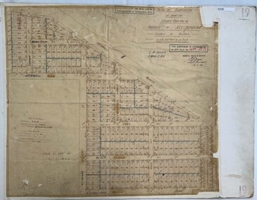
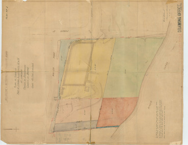
Poster - Planning Document, Shire of Diamond Valley et al, Subdivision Plan # 1026 - Parish of Nillumbik, County Bourke, Crown Allotment B Section 12, Eltham North, 1981-1984
Subdivision Plan # 1026 - Parish of Nillumbik, County Bourke, Crown Allotment B Section 12, Eltham North. This subdivision plan includes Ryans Road (also known as Government Road) and St Clems Street. The developer for this subdivision is Taunton Developments and the Surveyors are Fisher Cleeland Turner & Dwyer Vic, Surveyors and Engineers.An example of hard copy subdivision plans from the Greensborough area. Mainly from the Shire of Diamond Valley era (1964-1994).Plan (single sided) mounted on heavy card. Stamped and handwritten Council permissions, dates and other details. subdivision plans, shire of diamond valley, taunton developments -
 Tatura Irrigation & Wartime Camps Museum
Map, Part Murchison North Parish Plan
Ownership detail obtained from S.R. & W.S.C. rate book 1933. Part Murchison North Parish Plan with extent of "Kiota" property outlined, as in 1933, owned by Gerald N. Buckley, purchased in 1936 by Pargeter, and held until 1943. Note that Kiota Road west of the Tatura Murchison Road was unfenced in those years.kiota estate, pargester,buckley, dhurringile. -
 Ringwood and District Historical Society
Photograph, Parish Hall, Ringwood Street being partly demolished for extension to Coles Store. 1959
Written next to photographs (mounted on single sheet): SS0185a: "Parish Hall, Ringwood Street being partly demolished for extension to Coles Store, December 1958, January, 1959." SS0185b: "This was originally a state school built in 1889. Foundation stone taken to Ringwood SS." SS0185c: no inscription -
 Bacchus Marsh & District Historical Society
Map, Village allotments, Parish of Myrniong, County of Bourke
Myrniong is a village 9 kilometers west of Bacchus Marsh. Prior to 1863 the area was known as Blow's Flat. This map which was produced in 1903 and according to the catalogue record of this map held at the State Library of Victoria was based on an earlier map created in 1861. The early layout of streets for the village of Myrniong can be seen on this map. The streets shown are, Main Street, Hardy Street, Blow Street, Myrniong Street, Shuter Street, and Blackwood Street. An area marked as a reserve for a school can be seen between Hardy Street and Main Street.A single page paper map. A cadastral parish map of Myrniong in Victoria, showing numbered land allotments. Photo-lithographed at the Department of Lands & Survey, Melbourne, in 1903. Based on an original map created in 1861. The map is pasted into a bound volume containing 76 maps or plans in total. High resolution digital image stored on BMDHS computer network. Surveyed by John Hardy, Surveyor ; photo-lithographed at the Department of Lands & Survey, Melbourne by T.F. McGauran, 24.12.03myrniong parish plan, myrniong parish maps -
 Greensborough Historical Society
Poster - Planning Document, Shire of Diamond Valley et al, Subdivision Plan # 1018 - Parish of Nillumbik, County Bourke, Crown Allotment 4 Section 15, and Crown Allotment B Section 12, Eltham North, 1981-1982
Subdivision Plan # 1018 - Parish of Nillumbik, County Bourke, Crown Allotment 4 Section 15, and Crown Allotment B Section 12, Eltham North. This subdivision plan includes Ryans Road (also known as Government Road) and St Clems Street. The developer for this subdivision is Taunton Developments and the Surveyors are Fisher Cleeland Turner & Dwyer Vic, Surveyors and Engineers.An example of hard copy subdivision plans from the Greensborough area. Mainly from the Shire of Diamond Valley era (1964-1994).Plan (single sided) mounted on heavy card. Stamped and handwritten Council permissions, dates and other details. subdivision plans, shire of diamond valley, taunton developments -
 Greensborough Historical Society
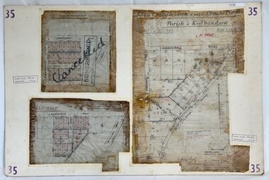
Poster - Planning Document, City of Heidelberg, Subdivision Plan # 35 - Parish of Keelbundoora, Crown Portion 16, Watsonia, 1918
Subdivision Plan # 35 Parish of Keelbundoora, Crown Portion 16: 3 plans on one sheet. Plan 1: Lambourn Road, Boger Street, Kenmare Street, Greensborough Road, Devonshire Road, Watsonia (stamped "Superseded"). Plan 2: an update of plan 1. Plan 3: Also Lambourn Road, Boger Street, Kenmare Street, dated 1918, Shire of Heidelberg.An example of hard copy subdivision plans from the Greensborough area. Mainly from the Shire of Diamond Valley era (1964-1994).3 Plans (single sided) mounted on heavy card. Stamped and handwritten Council permissions, dates and other details. Plan 1 has been stamped in red "SUPERCEDED" and overwritten by hand "Cancelled".subdivision plans, city of heidelberg, greensborough, main street greensborough, shire of heidelberg, watsonia -
 Whitehorse Historical Society Inc.
Newspaper - Article, Bishop cited in Parish Rufus
Article in Herald-Sun. Sacked vicar and 5 parishioners have sought to impeach the Anglican Primate, Archbishop Keith Rayner over a row at St Luke's, Vermont. It flared in 1994 when Rev Greentree sacked the parish music and youth leaders whom he thought were not working in the parishioners' interests. After a church inquiry Dr Rayner revoked Mr Greentree's licence.st lukes anglican church, vermont, churches, vermont, greentree, david (rev), rayner, keith, dr., abp. -
 Federation University Historical Collection
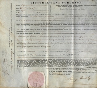
Document, Grant, by Purchase, Parish of Burrumbeet, Victoria, 1857, 1857
John Ettershank of Ballarat purchased land for Ninety-three pounds, two shillings and four pence. This was ten acres, two roods and thirteen perches in the County of Ripon Parish of Burrumbeet. The land sold at Ballarat as Lot No 37. The document was witnessed by Sir Henry Barkly, Knight Commander of the Most Honorable Order of the Bath, Captain-General and Governor-in-Chief of the said Colony and Vice-Admiral, at Melbourne, VictoriaThick cream paper, badly stained. Hand written Official seal Dated 16 April 1857 Signed: Henry Barkly -Governor-in-Chief of the Colony Signed: William C Haines - Chief Secretary and Registrarjohn ettershank, ballarat, county of ripon, parish of burrumbeet, sir henry barkly, captain-general, governor-in-chief -
Ringwood and District Historical Society
Memorabilia, Australian Natives Association, Invitation to Seventh Annual Smoke Social in the Parish Hall, Ringwood, Victoria - 1939
Buff coloured card with gold printingThe President and Committee of the Ringwood Branch (No.309) Australian Natives' Association request the pleasure of the Company of Mayor & Councillors, Borough of Ringwood at the Seventh Annual Smoke Social in the Parish Hall, Ringwood, Monday, 4th September, 1939 at 8 p.m. RSVP to O. R. Lynes, Vernon St. Croydon by Monday, 21st August. -
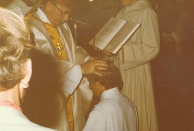 Ringwood and District Historical Society
Photograph, Ordination of Len Phillips as a Deacon - Holy Spirit Parish, North Ringwood, 20/9/1981, 1981
Two colour photographs of religious ceremony.Written on back of one photograph: "Holy Spirit Parish, North Ringwood 20/9/81. Bishop ordains Len Phillips as a Deacon. The laying on of hands." Written on back of second photograph: "Ordination as a Deacon. Fr. Mogg robes Len Phillips, Church of the Holy Spirit, North Ringwood. 20/9/81." -
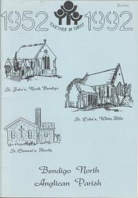 Bendigo Historical Society Inc.
Book - BENDIGO NORTH ANGLICAN PARISH
24 page soft cover booklet 'Bendigo North Anglican Parish' A brief history of the 3 churches from 1952 to 1992. St John's, North Bendigo St Luke's, White Hills St Clement's, Huntly Sketches of churches on front cover. Lists of Parish CouncillorsAnglican Parish of North Bendogo -
 Greensborough Historical Society
Poster - Planning Document, City of Heidelberg, Subdivision Plan # 19 - Parish of Keelbundoora, Crown Portion 16, Watsonia "Black's subdivision', 1924
Subdivision Plan # 19 - Parish of Keelbundoora, Crown Portion 16, Watsonia "Black's subdivision". This subdivision plan includes proposed street names which were later changed (e.g. Morwell Street (not Morwell Avenue) now called Greenwood Drive). Includes Lambourn Road, Black Street, Grace Street, Eden Avenue, High Street, Kenmare Street, Morwell Avenue, Greensborough Road, Mundy Street, Ladd Street.An example of hard copy subdivision plans from the Greensborough area. Mainly from the Shire of Diamond Valley era (1964-1994).Plan (single sided) mounted on heavy card. Stamped and handwritten Council permissions, dates and other details. subdivision plans, city of heidelberg, greensborough, main street greensborough, shire of heidelberg, watsonia, black family -
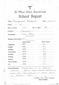 Greensborough Historical Society
School Report Card - Digital Image, St Mary's Parish Primary School, Margaret Hassett, 1960 - Gr1539, 1960_
A collection of school report cards from Margaret Scott (nee Hassett) at St Mary's School Greensborough, 1960.Copies of 4 school reportsPrinted report with handwritten marks and comments.margaret scott, margaret hassett, st marys parish primary school greensborough -
Glenelg Shire Council Cultural Collection
Book - Book presented to Syd Cuffe, Town Crier, Melbourne Victoria Australia, c. 1996
Book presented to Syd Cuffe on the 7th Victorian Town Crier Championships, Melb. 24th October 1998, presented by Ivan Deveson, OA, Lord Mayor of Melbourne. -
 Monbulk RSL Sub Branch
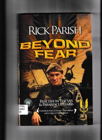
Book, Rick Parish, Beyond fear: Real life in the SAS and pararescue teams, 2009
This is the true story of a man who has taken on all the action he can get. Go behind the scenes with Rick Parish as he serves in the SAS Regiment then as Base Commander and Training Commander for Pararescue at the NSCA, Victorian Division. Every fight is a fight for survival, in a place that only lies Beyond Fear.p,205.non-fictionThis is the true story of a man who has taken on all the action he can get. Go behind the scenes with Rick Parish as he serves in the SAS Regiment then as Base Commander and Training Commander for Pararescue at the NSCA, Victorian Division. Every fight is a fight for survival, in a place that only lies Beyond Fear.sas - history, rick parish - biography -
Tatura Irrigation & Wartime Camps Museum
Book, Pages of pages, 1984
A collection of verses by Canon Cliff Page Rector All Saints Anglican Church, Tatura. 1963-1973. Wildflower paintings by Mawditt Jean Page. Cream and beige covers, title and author on front. St Paul's Anglican church, Canterbury, in illustration on front cover. 67 pagesauthors name and date. page 3.canon cliff page, all saints anglican church, tatura anglican church, mawditt jean page -
 Otway Districts Historical Society
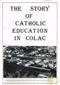
Book, Parish Bicentenary Committee, St Mary's Catholic Church, The story of Catholic education in Colac, ca. 1988
The story of Catholic education in Colac. Soft cover. 60 p.; illus. ca. 1988.catholic education; colac; roman catholics; st mary's catholic church; st mary's presbtery; st mary's school; st joseph's college; convent of mercy; -
 Federation University Art Collection
Artwork, Lagoon
This item is part of the Federation University Art Collection. The Art Collection features over 2000 works and was listed as a 'Ballarat Treasure' in 2007.art, artwork, parish vivienne -
 Narre Warren and District Family History Group
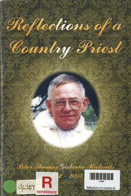
Book, Peter Rickards, Reflections of a country priest : Peter Thomas Gisborne Rickards S.S.C. 1942-2003, 2003
Story of Peter Thomas Gisborne Rickards 1942 - 200382 p.; 21 cmnon-fictionStory of Peter Thomas Gisborne Rickards 1942 - 2003served at traralgon, moe, heyfield, bunyip, st peter's eastern hill -
 Melbourne Tram Museum
Drawing, "Plan of Survey of Part of Crown Allotments 15 and 16 at Hawthorn, Parish of Boroondara, County of Bourke", 1922
Drawing, coloured with water based drawing wash, titled "Plan of Survey of Part of Crown Allotments 15 and 16 at Hawthorn, Parish of Boroondara, County of Bourke". Shows the tram track, Wallen Road, changes around the intersection with Power St, buildings. A note at the bottom notes who owns what - MMTB and City of Hawthorn. Prepared by H. S. McComb, licensed Surveyor 6-9-1922. Stored folded.Stamped "Drawing Office" "Office Copy" and in red pencil "Hawthorn" in the bottom right hand corner, and on the rear "Drawing Office" "Office Copy" and "Hawthorn Depot" in pencil.trams, tramways, htt, mmtb, hawthorn depot, plans -
 Ringwood and District Historical Society
Map, Plan of the Parish of Warrandyte County of Evelyn - 1841
Blueprint copy of Survey Map W27 detailing original Selectors' names and property locations between Yarra Yarra River (Warrandyte) and Mullum Mullum Creek (Ringwood). List of Parish map references including property bearings, distances in Links, and markings on trees. Pound Bend area of Warrandyte marked as Reserve For Aborigines. Descriptive remarks include areas marked "scrubby, flat, sandy soil". Several other references faded and illegible.(Map) by T.H. Nutt Feb 3 1841. -
 Eltham District Historical Society Inc
Document - Map, Victoria. Department of Crown Lands and Survey, Town of Eltham, Parish of Nillumbik, County of Evelyn, 2 October 1929
Township of Eltham, Parish of Nillumbik, County of Evelyn / lithographed at the Department of Lands & Survey Melbourne 5th June 1888, amended 2 October 1929 This amendment from the 1888 original shows the reserve for the the State School marked as permanent with dimensions added to Main Road and block frontages along Main Road between Mount Pleasant Road and Dalton Street and Metery Road Possibly photocopied from a copy held at PROV by Harry Gilham whilst resaerching Eltham Primary School history in 1995.a. armstrong, a. lavard, arthur c. allan, arthur c. allen, b. bowatere, baxter street, benjamin oliver wallis, bolton steet, c. souter, c.s. hain, cemetery reserve, charles brown, charles newman, charles symons wingrove, christopher caldwell, church of england, d. anderson, dalton street, david ballard, e. james, e.m. peck, edward dumaresq, eltham town, ely street, f.e. falkiner, f.m. peck, falkiner street, flint street, g. buckingham, g. drabble, george stebbing, godalmin street, h. peck, h.c.whess, h.h. farquharson, h.j. bews, henry stooke, j. goer, j. mcdonald, j. mclaren, j. roberts, j.b. knagers, james irish, jane bailey (nee matthews), john l. smith, john mason, john scott, john smith, joseph stevenson, joseph verse, k. wingrove, k.e. dunstan, kerby street, kirby street, location tbd, m. coman, map, michael o'shea, o.b. mccutcheon, p. & g. tumbull, p.k. mccaughan, p.p. cotter, porter street, pound reserve, robert hepburn, roman catholic church, s. evans, samuel dagley, samuel phillips, samuel ramsden, t. upton, t. watkins, t.a. stark, t.c.b. batt, t.p. cross, thomas grant, thornton street, w. adam, w. blain, w. long, w. watkins, w.f. ford, w.h. hull, w.r. belcher, w.t. schultz, william thomas, eltham primary school, eltham state school, eltham state school no. 209, quarry reserve -
 Bacchus Marsh & District Historical Society
Map, Allotments in the Village of Rowsley, Parish of Gorrocburkghap, County of Grant c.1856
Rowsley is a locality 11 kilometers south-west of Bacchus Marsh. The date of this map is uncertain. A very similar map held by the State Library of Victoria (SLV) contains slightly more information than this copy and is dated as an 1856 map. SLV reference: 'Allotments in the Village of Rowsley, Parish of Gorrocburkghap, County of Grant', by T. Nixon, Assistant Surveyor, May 1856 ; Surveyor General’s Office, July 18 1856 (lithographed by R. Meikle). (1856). Melbourne: Surveyor General’s Office. MAPS 820 BJE 1837- ROWSLEY 1856. A single page paper map. A cadastral map of the Village of Rowsley in Victoria, showing numbered land allotments. 57 allotments are shown on the map and some areas set aside as reserves. Allotments 8, and 10-16 are outlined in red ink and allotment 9 has a cross in red ink on it. The map is pasted into a bound volume containing 76 maps or plans in total. High resolution digital image stored on BMDHS computer network. rowsley victoria history, rowsley victoria maps -
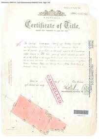 Ringwood and District Historical Society
Document, Certificate of Title - Crown Sections 12, 15, and Part of Section 20 (later including Warranwood, Vic.), Parish of Warrandyte, County of Evelyn - 11 June, 1898
A4 copies of Landata Victoria Historical Search documents - Vol 2687 Fol 537231.The Mutual Assurance Society of Victoria Limited of 406 Collins Street Melbourne, County of Bourke, is now the proprietor of an Estate in Fee-simple - 1,640 acres 3 roods 31 perches or thereabouts, being Crown Sections 12, 15, and part of Crown Section 20, Parish of Warrandyte, County of Evelyn. TRANSFER - 13th March, 1899 - 17ac 3rds 5per to The President Councellors and Ratepayers of the Shire of Lilydale (Part of Crown Section 20). -
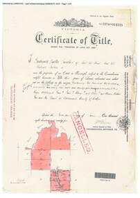 Ringwood and District Historical Society
Document, Certificate of Title - Crown Allotments 4A, 4B, 11A, 11B, and Crown Sections 5 and 6 (later including Wonga Park, Vic.), Parish of Warrandyte, County of Evelyn - 17 June, 1895
A4 copies of Landata Victoria Historical Search documents - Vol 2574 Fol 514725.Frederick Walter Purches of Ascot Vale, Wholesale Butcher, is now the proprietor of an Estate in Fee-simple - 2,291 acres 3 roods 24 perches or thereabouts, being Crown Allotments 4A, 4B, 11A, 11B, and Crown Sections 5 and 6, Parish of Warrandyte, County of Evelyn. Transfers include The Mutual Assurance Society of Victoria Limited, 15th August, 1896, The President Councellors and Ratepayers of the Shire of Lilydale, 13th March, 1899. -
 Eltham District Historical Society Inc
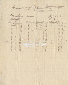
Document - Folder, Greensborough Railway Station Estate, Lots 26, 26A and 26B, Crown Portion 3, Parish of Nillumbik, County of Evelyn (Rattray Road, Montmorency)
Crown Portion 3 of Eltham, Parish of Nillumbik, County of Evelyn, Lots 26, 26A and 26B were part of the Greensborough Railway Station Estate. The land detailed is bounded by present-day Rattray Road, Reichelt Avenue, Wooded Way and Ryrie Court, Montmorency. Originally purchased in September 1913 by George William Miller, signwriter of Greensborough and Harry Frederick Miller, the land was sold to Mrs Margaret Barr Honeyman, 24 June 1918 on mortgage for £400, deposit paid £150. In February 1920, Mr Honeyman called for the title and paid off the loan early, settlement occuring 11 October 1920. Contents: 1. Handwritten payment plan (Sep 1913 to Mar 1923) for Lots 26, 26A and 26B being parts of Crown Portion 3, Parish of Nillumbik, County of Evelyn on the plan of subdivision making up the Greensborough Railway Station Estate situated on Rattray Road; purchased for £179.2.0 with a deposit of £18.0.0. 2. Receipt: From Messrs G.W. and H.F. Miller for £11.15.8 being instalment and interest, 9 Sep 1913 3. Invoice: To Messrs G.W. and H.F. Miller for £11.12.0 being instalment and interest due 15 Sep 1914 4. Contract of Sale: George William Miller and Harry Frederick Miller to Mrs. Margaret Barr Honeyman, in respect of sale of Lots 26, 26A and 26B for £400.0.0, 24 June 1918. Deposit of £150.0.0 balance to be paid half yearly instalments of £15 with interest at 5% per annum added. 5. Letter: Percy J. Russell, Solicitor to G.W. Miller, 5 Feb 1920 advising Mr Honeyman has called for the title and wishes to pay off mortgage. 6. Letter: Percy J. Russell, Solicitor to G.W. Miller, 11 Oct 1920 advising settlement and payment of Miller to Honeyman.contract of sale, george william miller, greensborough railway station estate, harry frederick miller, land sale, margaret barr honeyman, montmorency, rattray road, reichelt avenue, ryrie court, wooded way -
 Eltham District Historical Society Inc
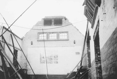
Photograph - Digital Photograph, Marguerite Marshall, Parish Hall, St John's Anglican Church, Diamond Creek, 7 September 2008
The building was designed by Charles Maplestone of Heidelberg, son-in-law to Anthony Beale of St Helena. Maplestone was a prominent architect who came out to Australia with his family in 1852. The foundation stone was laid by Mrs Isabella Maplestone on 11th November 1867. The bricklayers for the church were George Stebbing, H Limmer, H Spicer and a Mr Timm while Thomas Day was the stonemason. Another three years were to pass before sufficient money could be raised for its completion. It was opened by Bishop Perry on 1st November, 1870. The church bell which hung under a tree for 50 years until it was incorporated in the parish hall was brought out from England and presented by Charles Orme. In 1916, the estate of George Martin Pizzey left sufficient money to build the red brick hall, which still stands today (2023) though in January 1969 the hall and bell tower were badly damaged by bushfire. Coincidentally the former home of benefactor, George Pizzey was destroyed in the same fire. Of particular significance are the interior and exterior of the church, the Sunday school and hall with emphasis on pre-World War I fabric (excluding the 1990s additions) and the three coloured glass windows currently suspended in the 1990s entry foyer. In 2011 further alterations were made to the front of the Church. The church is historically significant because it was the oldest public building in the former Diamond Valley Shire, is amongst the oldest buildings in the Shire of Nillumbik and is associated with the early settlement of the Diamond Creek district. The church is historically, socially and spiritually significant because it has been a place of worship for over 150 years and continues to be, an important meeting place in the Shire. The church is aesthetically significant for the three stained glass windows executed by the noted stained glass manufacturers, Ferguson & Urie, as well as the supporting coloured glass windows in the church. The Sunday school & parish hall is architecturally significant because the hall is a well executed and preserved example of the work of noted church architects, North & Williams. It is historically significant because it is connected with local parishioner and Melbourne industrialist, George Pizzey, who bequeathed funds for its construction. Covered under Heritage Overlay, Nillumbik Planning Scheme. National Estate Ntionl Trust of Australia (Victoria) Local significance Published: Nillumbik Now and Then / Marguerite Marshall 2008; photographs Alan King with Marguerite Marshall.; p85 References: St Johns Anglican Church complex, Sunday School and Parish Hall 61 Main Street DIAMOND CREEK, NILLUMBIK SHIRE. (2023, June 7). Retrieved from https://vhd.heritagecouncil.vic.gov.au/places/64023 Diamond Creek, VIC. – St John’s Anglican (2023, June 7). Retrieved from https://www.churchhistories.net.au/church-catalog/diamond-creek-vic-st-johns-anglican This collection of almost 130 photos about places and people within the Shire of Nillumbik, an urban and rural municipality in Melbourne's north, contributes to an understanding of the history of the Shire. Published in 2008 immediately prior to the Black Saturday bushfires of February 7, 2009, it documents sites that were impacted, and in some cases destroyed by the fires. It includes photographs taken especially for the publication, creating a unique time capsule representing the Shire in the early 21st century. It remains the most recent comprehenesive publication devoted to the Shire's history connecting local residents to the past. nillumbik now and then (marshall-king) collection, st john's anglican church, diamond creek, parish hall -
 Lakes Entrance Historical Society
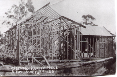
Photograph - Metung Hall, 1920
Building of Hall commenced 1920.Black and white photograph of the Metung Parish Hall under construction. Metung VictoriaMetung Parish Hall 5pm August 14 1920, Working Beereligion, halls -
Stawell Historical Society Inc
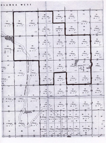
Map, Lexington County of Borong 1910, 1910
Parish to the North East of MoystonA2 Parish mapPhoto Lithographed at the Department of Lands and Survey. Melbourne by T.F. McGauran 5.12.10survey -
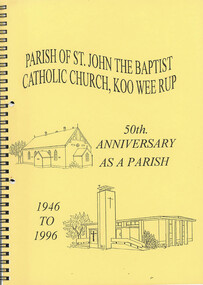 Narre Warren and District Family History Group
Book, Parish of St. John the Baptist Catholic Church, Kooweerup. 50th Anniversary as a Parish. 1946 - 1996
50th Anniversary of the parish of St John the Baptist Church in Koo Wee Rup. 1946 - 1996non-fiction50th Anniversary of the parish of St John the Baptist Church in Koo Wee Rup. 1946 - 1996kooweerup (vic.)