Showing 6751 items
matching rivers
-
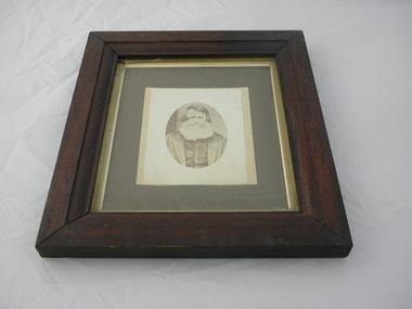
 Warrnambool and District Historical Society Inc.
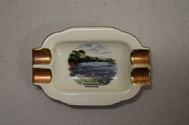
Ashtray, Alka Kunst, Warrnambool Hopkins River, c. 1960
This item was bought as a souvenir of Warrnambool in the mid 20th century when cigarette smoking was more widespread and was socially acceptable. Tourism in Warrnambool has been an important industry for over 100 years. In the late 19th century Warrnambool was promoted as a spa resort with its mild climate, sea bathing and its hot and cold sea water baths complex. Today visitors come in winter for the May Racing Carnival and to see the Southern Right whales at Logans Beach and in summer they come for a beach holiday. The image on the dish shows the Warrnambool Hopkins River near its mouth. The boatshed is no longer there with sections of the building being relocated to a site in Henna Street and used for indoor recreational purposes.This ash tray is retained as an example of a local tourist souvenir sold to tourists in the 1960s. This is a small white china dish made in an oval shape and slightly raised from the surface on which it sits. The ends of the dish have four gold coloured indents for stubbing cigarettes. There is a gold rim around the edge of the dish and a coloured image of the old boat shed and jetty on the Hopkins River in Warrnambool. On the base of the dish is the logo of the maker and printed details.Warrnambool Hopkins River Alka Kunst Bavaria tourism in warrnambool, history of warrnambool -
 City of Warrnambool Rowing Club
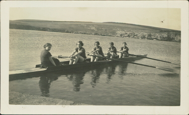
Black and white photograph, 1936
There was a (Warrnambool) Ladies Rowing Club from about 1913. They were autonomous with their own shed, committee and coaches.The photograph is of a ladies crew in a sweep four. They are beside the bank of the Hopkins River, Warrnambool.The back of the photograph has "Before a training spin on the Hopkins River 1936".rowing, warrnambool, hopkins river, ladies rowing, warrnambool rowing club, warrnambool ladies rowing club, city of warrnambool rowing club, city of warrnambool rowing club -
 Lakes Entrance Historical Society
Photograph - Mitchell River, Glenaladale Victoria, 1994 c
... Rivers ...Colour photograph of Mitchell River from Billy Goat Bend showing steep gorge between heavily forested high banks. Glenaladale Victoria. Also two photographs of U3A Geology group on track overlooking Mitchell River and black and white photograph of Billy Goat Bend donated by Lakes Post Newspaper 6 January 2010 topography, rivers -
 4th/19th Prince of Wales's Light Horse Regiment Unit History Room
Framed Picture, Light Horse, c 1917
Printed framed photo of Light Horse fording Jordan River during World War 1Colarts Sydney Caption: Light Horse fording Jordan River -
 Federation University Historical Collection
Photograph - Colour, Leigh River near Garibaldi Bridge
The Leigh River is a major tributary and catchment of the Barwon River. Fed by the Yarrowee River that rises near Ballarat, the Yarrowee reaches its confluence to form the Leigh in the vicinity of Cambrian Hill and Golden Plains Shire. The Leigh River rises below Mount Mercer and flows generally south, joined by three minor tributaries before reaching its confluence with the Barwon River, southeast of the central business district of Inverleigh. The river descends 265 metres (869 ft) over its 61-kilometre (38 mi) course. (https://en.wikipedia.org/wiki/Leigh_River_(Victoria)Relates to historical information about flooding of the Leigh River in 1933. Relevant to the history of Garibaldi and Durham Lead.A number of colour photographs showing the Leigh River between Garibaldi and Durham Lead, Victoria, .1 - .3) photographs of the Leigh River in flood .4 - .18) general photos of the Leigh River and surrounding countryside .19) broad angle photograph of the Leigh River and surrounding countryside leigh river, garibaldi, garibaldi bridge, durham lead, vincent family -
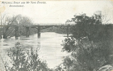 Lakes Entrance Historical Society
Postcard - Wy Yung Bridge Mitchell River Bairnsdale Victoria, AW Buriman, 1913 c
... Rivers ...date on back Sat. 8/ 3/ 1913Black and white postcard of Wy Yung Bridge opened in April 1889 built originally as a draw bridge over Mitchell River Bairnsdale VictoriaMitchell at Wy Yung Bridge Bairnsdalebridges, rivers -
 Kew Historical Society Inc
Photograph, Marnie McLeod, Floods on the River Yarra at Kew, 1916
The donation was accompanied by the following letter from the donor: "Hi. I found these in with family photos. Taken by family as Mamie McLeod was living in Fellows Street, Kew, so would be near there. Retain (or discard) as you see fit." [Donor's name and address withheld from public view]. To gain an insight into the flood levels at Kew, it is worth reading newspaper accounts of the event. The Age published an article - Valuable Gardens Destroyed at Kew - on 25 September 1916: "VALUABLE GARDENS DESTROYED AT KEW. From the heights of Studley Park, Kew, a splendid view of the flood waters can be obtained, and yesterday afternoon, despite continuous rain, crowds of citizens assembled there to witness the spectacle. There is a vast stretch of water some 300 or 400 yards broad, above the foot bridge connecting Gipps-street, Collingwood, and Studley Park. The river is only about 3 feet from the top of the embankment connecting with the ramp of the bridge on the Studiey Park side. When the upper llood waters come down it is almost a certainty that tne embankment will be submerged and the bridge rendered impassible. Below the bridge the waters again stretch out, and have submerged all the low-lying land on the Collingwood side and invaded the back premises ot the Kodak Co., Phoenix Biscuit Factory, a tannery adjoining thereto, the Shamrock Brewery, and Chinese gardens in the vicinity. At Walmer-street-bridge, at the end of Studley Park, the low-lying land on the Kew side is covered with water to the depth of many feet. Tlie land in question is owned in a great part by Mr Frank Lavers who haa gone in for intense culture on a pretty liberal scale on both the slopes of the hill and on the river flat. On the latter he is cultivating many acres of asparagus, and has at a considerable cost spent three years in preparing the ground and installing an irrigation system, reticulated from the Yan Yean water supply. This year the asparagus was put down, and the plants were in a promising condition. Tlie flood waters are now flowing fast over the land. The crop is ruined, and three years' work and expenditure destroyed. Mr. Laver's private residence fortunately is high above flood level, but two houses he owns off Young-street have been flooded out. Having been warned in time, the tenants removed their furniture hefore the water came down to Mr. Laver's residence, where they themselves have been given accommodation in the meantime. All the river flats in East Kew are under water. One or two low-lying houses have been flooded. Chipperfield's boat shed at Willsmere is nearly covered, and some Chinese gardens in the vicinity are several feet under water."This, and the other three photographs donated of floods in Kew are believed to be the earliest in the collection. Together with our original MMBW River Yarra map showing flood levels, these items, when compared allow researchers to gain a visual perspective of the extent of the flood in 1916. Panoramic view, believed to be looking north towards Fairfield from the Zig-Zag Bridge on the River Yarra. The inscription on the reverese identifies it as taken before 1920.Inscription on reverse in ink "(pre 1920) Flood from Zig-zag bridge Yarra River, Kew Vic."river yarra, kew, floods 1916, zig-zag bridge -
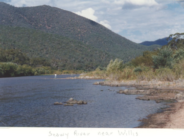 Lakes Entrance Historical Society
Photograph - Snowy River near Willis Victoria, M Holding, 1994 c
... Rivers ...Colour photograph of the Snowy River in the alpine Country near Willis Victoriageology, topography, rivers, mountains -
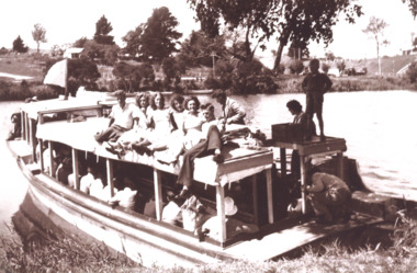 Lakes Entrance Historical Society
Photograph, Peels launch Zephyr on Tambo River near bridge at Swan Reach Victoria, 1940 c
... Rivers ...Black and white photograph of Peels launch Zephyr filled with passengers moored at landing place on Tambo River near bridge at Swan Reach Victoria. Also a second black and white photograph of Peels launch Zephyr in Tambo River with Swan Reach bridge in backgroundboats and boating, tourism, rivers -
 Marysville & District Historical Society
Photograph (Item) - Colour photograph, Travel Victoria, 2006
A colour photograph of the Steavenson River in Marysville in Victoria.A colour photograph of the Steavenson River in Marysville in Victoria. The Steavenson River is named after the Victorian Assistant Commissioner of Roads and Bridges, John Steavenson who arrived in Victoria in the early 1860s.steavenson river, marysville, victoria, photograph, john steavenson -
 Kew Historical Society Inc
Photograph - Burgess House, Victoria Street (Abbotsford), 1880-1900
Major floods recurred of the Yarra River on a regular basis. A flood in 1901 destroyed this house in Victoria Street, Abbotsford. Later print copy of an original photograph. Home of C/N Burgess on the south side of Yarra River. The buildings were washed away in a flood in 1901 The house was in the same location as that on which Handley & Tilly was later built. This would locate it on the north side of Victoria Street, Abbotsford between Burnley Street and the Victoria Street Bridge. Photo shows three men and one woman working in an established garden in front of a weatherboard cottage."Home of C/N Burgess on south side of river; washed away in 1901; Handley & Tilly on site"yarra river -- floods, yarra river flood -- 1901, burgess family -- victoria street -- abbotsford (vic.) -
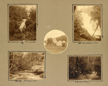 Marysville & District Historical Society
Photograph (item) - Black and white photographs, Unknown
An album page with five photographs of 5 natural attractions in an around Marysville in Victoria.An album page with five photographs of 5 natural attractions in an around Marysville in Victoria.Steavenson Falls 18/ Steavenson River 21/ "Land of mountain or flood" 20/ a Mountain Stream 22steavenson falls, steavenson river, marysville, victoria, waterfalls -
Tatura Irrigation & Wartime Camps Museum
Photograph, Eildon Reservoir - Goulburn River, 1918
Taken by photographer for State Rivers and Water Supply Commission.Medium sized black and white photograph. Eildon Reservoir on the Goulburn River / Overall picture of dam (Right of wall) filled with water and some leisure craft moored near shore and huts / Dam wall and spillway / tree covered hills beyond"Eildon Reservoir - Goulburn River / Capacity - 306,000 acre feet / Rock filled dam with mass concrete spillway / Total length of dam - 3000 feet / Maximum depth of water - 123 feet - etc"victorian state rivers and supply commission, eildon dam -
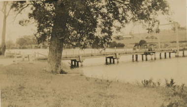 Lakes Entrance Historical Society
Photograph - Swan Reach Bridge, 1/12/2027 12:00:00 AM
The temporary bridge was in use until for four years, following the collapse of the permanent bascule bridge on 17 November 1925 due to attack by teredo worm. The temporary bridge was swept away during a flood in June 1930.Sepia toned photograph of a pontoon bridge over the Tambo River at Swan Reach Victoria, built as a temporary crossing after the collapse of the bascule bridge on 17 November 1925. Tambo River Christmas 1927 on reversereligion, buildings -
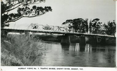 Orbost & District Historical Society
black and white photograph, Murray Studio, Murray Views, 1934
After the flood damage of 1934, the bridge was repaired with a new section in the middle. This bridge remained largely unchanged until its final demolition in 1975 after construction of the new concrete bridge and Orbost by-pass which exists today. This photograph is one of a collection of photographs produced by Murray Views, Gympie. It features eight scenic b/w photographic prints of Orbost and surrounding tourist areas.Photographs like these allowed tourists to send many images of their holiday destination or hometown in the one small package. Fred Murray opened Murray Studios in Gympie in 1906. The postcard and souvenir production side of the business initially covered Gympie and surrounding regions, but Murray expanded the business to include North Queensland, New South Wales and even Adelaide. It was opened under a separate name, Murray Views, in 1929. In 1945 the business was taken over by Murray’s nephews who began postcard folder production. This is a pictorial record of an early bridge across the Snowy River at Orbost.A black / white photograph / postcard of the Snowy River Bridge at Orbost.on front bottom printed - Murray Views No.4 Traffic Bridge , Snowy River, Orbost, Vic.orbost-snowy-river-bridge -
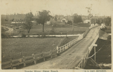 Lakes Entrance Historical Society
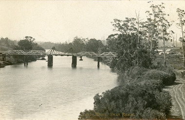
Postcard, Vogt Bairnsdale, Tambo River Swan Reach, 1920 c
Note on back to Ella from her brother Don dated 1920Black and white postcard showing the old Swan Reach bridge over the Tambo River looking east. Buildings L to R Riverslea guesthouse and school with high pitched roof. Swan Reach VictoriaTambo River Swan Reachwaterways, boats and boating, township, guesthouses, bridges -
 Ballarat Heritage Services
Photograph - Photograph - Colour, Clare Gervasoni, Brembo River, Near San Giovanni Bianco, Lombardy, Italy, 2001, 2001
The Brembo River is a 74-kilometer river which runs entirely within the Province of Bergamo in the Lombardy Region of Italy.Colour photograph of the Brembo River.brembo river, san giovanni bianco, italy -
 Marysville & District Historical Society
Photograph (Item) - Colour photograph, Travel Victoria, 2006
A colour photograph of the Steavenson River in Marysville in Victoria.A colour photograph of the Steavenson River in Marysville in Victoria. The Steavenson River is named after the Victorian Assistant Commissioner of Roads and Bridges, John Steavenson who arrived in Victoria in the early 1860s.steavenson river, marysville, victoria, photograph, john steavenson -
 The Beechworth Burke Museum
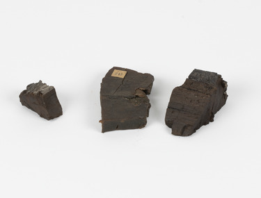
Geological specimen - Coorongite
Coorongite is a dark, rubber-like, highly resilient structureless algal deposit. In the Coorong district of South Australia it occurs in moderate quantities associated with the coastal swamps and sand dunes which extend for a considerable distance east of the mouth of the Murray. This particular specimen was recovered from the south of the Coorong River, South Australia. A type of sediment rich in organic matter, Coorongite is the unlithified end-member of the sapropelic coal series. The members of the sapropelic coal series can be ranked in order as sapropel (the unlithified form), sapropelic-lignite, and sapropelic-coal (the lithified forms) based on increasing carbon content and decreasing volatile content. Sapropel (Coorongite) is an unlithified dark, pulpy, fine organic mud containing concentrations of algae and miospores that are more or less identifiable. Coorongite is typically found as an algae like substance, that can be found in irregular size pieces. Coorongite was believed to be dried up oil due to its rubber-like texture. The Coorongite is also soft to the point where it can be cut into with a knife or it can be broken and torn by hand. Otherwise known as 'Kurangk', the Coorong River is home to the Ngarrindjeri people, which acts as both a place for gathering food and a spiritual place. In 1852 the first sight of Coorongite was found along the Coorong River. The finders mistook the Coorongite for dried up oil, which lead to the belief that there were oil reserves under the Coorong River. Between the 1860s and the 1930s the Coorong River became a place where mining oil and Coorongite became precedent. Nowadays, the local council and the South Australian Government are working together with the Ngarrindjeri people to sustain and preserve the Coorong River and the culture that is with it. Soon after gold was discovered in 1851, Victoria’s Governor La Trobe wrote to the Colonial Office in London, urging ‘the propriety of selecting and appointing as Mineral Surveyor for this Colony a gentleman possessed of the requisite qualifications and acquaintance with geological science and phenomena’. Alfred Selwyn was appointed geological surveyor in Australia in 1852 which began the Geological Survey of Victoria. Selwyn went on to collect geological samples and catalogue thousands of specimens around Australia. In 1853-69 the Geological Survey issued under Selwyn's direction sixty-one geological maps and numerous reports; they were of such high standard that a writer in the Quarterly Journal of the Geological Society of London bracketed the survey with that of the United States of America as the best in the world. During his years spent in Australia, Selwyn collected numerous significant geological specimens, examples of which are held in collections such as the Burke Museum.Coorongite is considered to be a mineral with a unique texture, where it can be both hard and soft. Coorongite can also be considered to be a rare mineral, as it is only located along the Coorong River and due to the mining of it, has left very few sources. It was believed at one point that Coorongite could be used to replace oil. This specimen is part of a larger collection of geological and mineral specimens collected from around Australia (and some parts of the world) and donated to the Burke Museum between 1868-1880. A large percentage of these specimens were collected in Victoria as part of the Geological Survey of Victoria that begun in 1852 (in response to the Gold Rush) to study and map the geology of Victoria. Collecting geological specimens was an important part of mapping and understanding the scientific makeup of the earth. Many of these specimens were sent to research and collecting organisations across Australia, including the Burke Museum, to educate and encourage further study.Three solid varyingly hand-sized pieces of wooden appearing organic matter derived from the river in the Coorong District in South Australia. A rubber-like, highly resilient structureless algal deposit.Specimen 245 page 69 / in Descriptive Register / "Elcestic Bitumen, / Coorangite" South of / Coorung River, South Australia . / C. WIllman / 15/4/21burke museum, beechwoth, indigo shire, beechworth museum, geological, geological specimen, mineraology, coorong, coorong river, kurangk, ngarrindjeri, south australia, coorongite, coorongite specimen -
 Lakes Entrance Historical Society
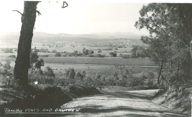
Photograph - Tambo River flats Bruthen Victoria, H D Bulmer, 1945 c
... Rivers ...Black and white photograph of Tambo River flats and Bruthen in distance with maize crop growing on flats Bruthen Victoriafarming, agriculture, rivers -
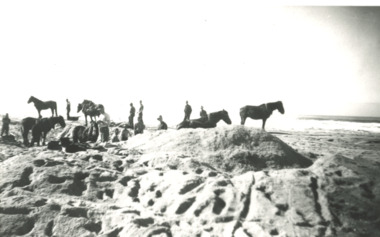
 Lakes Entrance Historical Society
Photograph - Snowy River Marlo Victoria, 1940 c
... Rivers ...No 5 in series of fiveBlack and white photograph showing men with horses and scoops opening an entrance to mouth of Snowy River Marlo Victoria public works, vegetation, rivers -
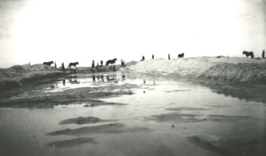
 Lakes Entrance Historical Society
Photograph - Snowy River Marlo Victoria
... Rivers ...No 2 in series of fiveBlack and white photograph showing men and horses with scoop opening an entrance to the mouth of the Snowy River Marlo Victoriaboats and boating, jetties, rivers -
 Kew Historical Society Inc
Photograph, Outer Circle Railway Bridge over River Yarra, c.1900
This photograph forms part of the Eric Sibly collection of images and information relating to the Outer Circle Railway which he donated to the Kew Historical Society in 1974. Heritage Victoria Citation (Abridged) "The Chandler Highway Bridge, a 137 metre wrought iron lattice-truss girder bridge with four spans supported on red brick piers with moulded bluestone cappings. The bridge has a cantilevered walkway along the west side. ...The Chandler Highway Bridge crosses the Yarra River and connects Alphington and Kew. It was completed in November 1890 as part of the Outer Circle Railway Line.Black & white photograph of the railway viaduct over Yarra River looking south towards Kew.Reverse: "Pre 1930. Outer Circle Railway Bridge over River Yarra (now Chandler Highway) - note bridge over line on Kew side for Asylum Farm". KH - 56. Kew Historical Society.chandler highway, railway bridges - kew (vic), sir john monash, outer circle railway, river yarra - kew (vic) -
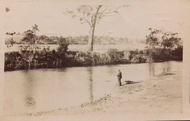 Kew Historical Society Inc
Postcard - Fishing, Yarra River, Henry Beater Christian, 1920s
Henry Christian (c.1809-91), the grandfather of the photographer, was one of the first settlers in Kew. He arrived in Victoria with his wife Agnes and son Orlando in 1855 on the Gypsy Queen. He established a rope-making business in Bulleen Road by 1858 but was declared insolvent two years later. In his final years, he was celebrated as one of the oldest living settlers of the district. His son, Orlando Henry Beater Christian (c.1853-1930) became a member of the Hawthorn Band and a foundation member of the Willsmere Swimming Club. Orlando and his wife Elizabeth had four children of which Henry Beater Christian (1886-1962) was the eldest.A photograph by Henry Beater Christian (1886-1962) of Pakington Street, Kew. Henry Beater Christian, was a keen explorer, not just of his immediate environment but also of the Victorian wilderness. His major opus is contained in two albums in which he records, sometimes in majestic detail and on other occasions the intimate features of the natural world. His photographic travels during the 1920s, often in solitary ramblings but on other occasions with companions, recall the heroic landscape photography of an earlier era, pioneered by Nicholas Caire. In addition to their aesthetic value, the albums are historically significant records within the State of Victoria, of what is now a distant point in time, and of places that have become radically altered through human intervention.Sepia 'real photo' postcard of Orlando Henry Beater Christian, fishing in the Yarra River. There appear to be cattle in paddocks on the other side of the river. Fairfield (sic) is on the horizon."Henry Beater's photograph of his father Orlando Henry Beater Christian whilst fishing in the River Yarra, Kew"yarra river -- kew (vic.), orlando beater christian, christian-washfold collection -
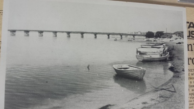 Peterborough History Group
Photograph - Curdies River, Peterborough Vic, circa 1955
Historic view of the river with old bridge in the backgroundSignificant as it shows the old Peterborough bridge, moored boats in the foreground and shoreline of the estuary at the time.Photograph of a postcardCurdies River, Peterborough Vicpeterborough 3270, curdies river, peterborough old bridge, vintage postcards, great ocean road, bridges -
 Wangaratta Historical Society
Framed Photo of William Clarke, William Clarke
The photo shows "William Clarke" who owned and operated the first commercial Punt across the Ovens River during the goldrush daysthe photograph shows "William Clarke" who was one of the first pioneers of the township of Wangaratta as it is now known. He also built one of the first hotels in Wangaratta.Brown wooden framed photograph, greyish background with silver surround around photo of William Clarke, one of Wangaratta's foundation pioneers. The wood is from the first punt. He was the owner of the first punt to cross the Ovens river, which he had built for 500 pounds. It was sunk in 1855 after the first bridge across the Ovens river was built.William Clarke1 1839 Wangaratta William Clarke 11 William Clarke 111(my father) Nell Clarke 1884-1965 William Clarke 1 Pioneer of Wangaratta Vic. 1839 This frame is made of oak from the punt he operated over the Ovens River during the goldrush days to Beechworthclarke family, punt, sydney hotel -
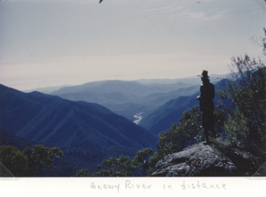 Lakes Entrance Historical Society
Photograph - Snowy River in the Alpine Country East Gippsland Victoria, Keith Scarce, 1979
... Rivers ...Colour photograph showing glimpses of the Snowy River in the Alpine Country East Gippsland Victoriaparks, rivers, topography, mountains -
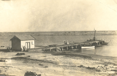 Lakes Entrance Historical Society
Postcard - Snowy River, Marlo Victoria, 1905 c
... Rivers ...Black and white postcard of the wharf and goods shed, boats moored at jetty, sand dunes in distance at Marlo on the Snowy River Victoriawaterways, boats and boating, rivers -
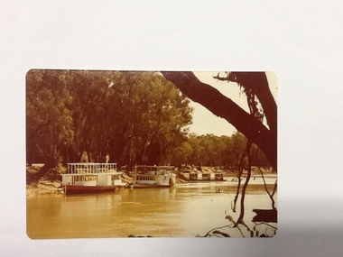 Port of Echuca
Colour Photograph, Approx.1979
This photo shows a river boat under construction on the eastern bank of the Murray river in the Echuca Port area where the boat shed and swimming pool were located in the 1970's. The boat shed can be seen through the trees but the swimming pool isn't visible. There is another river boat behind, possibly the Canberra.This photograph is of historical and social significance in that it shows the condition of the Murray river in the 1970's at an area used as the local swimming area on the Echuca side of the river. There is a river boat under construction (the frame work shows a bottom and top storey on the boat). This could be the Pride of the Murray. It is difficult to see the name on the river boat behind but it looks like the Canberra. Three houseboats are moored together, a bit further down the river.Colour photograph (post card size) of the Murray river looking north towards the boat shed building. Two river boats are moored by the left bank close to the swimming pool and three house boats can be seen moored further down the river. The river boat in the fore ground is under construction.Printed on reverse:" this paper manufactured by Kodak". Written in blue pen"12B"echuca, port of (riverboats), echuca, port of -
 Lakes Entrance Historical Society
Postcard - Bridges, 1906
Postcard dated 3 December 1913, Bairnsdale, addressed to Mrs Brewer, Metung, Gippsland.Black and white postcard showing wooden lift bridge over Tambo River, Swan Reach, Victoria. Old punt visible at left bank under bank, thick vegetation on right bank, houses in right background above Metung Road.Tambo River, Swan Reachbridges, waterways