Showing 621 items matching "1870s"
-
 Stawell Historical Society Inc
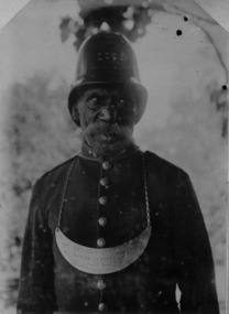
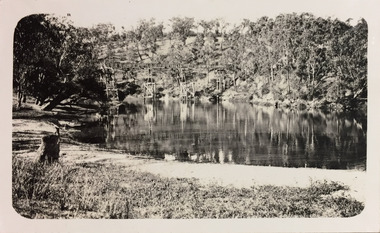
Photograph, Aboriginals at Carrs Plains, 2006
5563-1a Anthony Anderson 5563-1b King of Birchip 5563-1c Weapons demonstrated 5563-1d Carrs Plains Aboriginals 1870's 5563-1e Carrs Plains Aboriginals with Holford W 1870s 5563-1f Carrs Plains photos of Aboriginals from Vic Museum via Steve WettenhallPhotographs of Aboriginals at Carrs plains on CDstawell -
 Warrnambool and District Historical Society Inc.
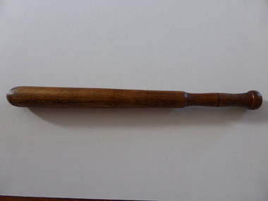
Batton, Police baton AP1340
This police baton or truncheon is typical of the ones used by police in Australia perhaps late in the 19th century or early in the 20th century. No information has yet been found as to the identity of the owner or the significance of the letters, ‘A P 1304’. There are several possibilities as the collection of the old Warrnambool Museum which operated from the 1870s to the 1960s included several police batons. The owner of this baton is not known but is retained pending further research.This is a wooden police baton. The rounded body is tapered towards the top and it has an incised ridge near the top and a knob on the top to form a handle. The ridge at the top may be for holding a string or rope to carry the baton on the wrist. The wood has been varnished but it is now much worn and discoloured. The letters have been etched into the surface.‘A P 1304’ history of warrnambool, police in warrnambool, police baton, police baton ap 1304 -
 Tarnagulla History Archive
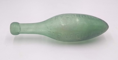
Torpedo Bottle - Whittaker Bros. Tarnagulla / Maryborough
David Gordon Collection. Torpedo bottles, also known as Hamilton bottles, were used for aerated or carbonated water. They were oval shaped with a neck at one end, and were deliberately designed so that they could not be stored upright. Torpedo bottles were in common use from the 1840s to the 1870s, when they were superseded by the Codd Neck bottle. -
 Greensborough Historical Society
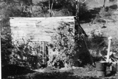
Photograph - Digital image, Outhouse, Willis Vale, 1920c
This photograph shows one of the out buildings at 'Willis Vale', a property owned and farmed by the Partington family from the 1870s. The derelict Willis Vale house was destroyed in 1964 when a fire originating from North Plenty Gorge - Kurrak Road - was lit by two teenage boys and made its way several kilometres down to Partington's Flat Greensborough.The hoe of a pioneer Greensborough family.Digital copy of black and white photograph.willis vale, partington family -
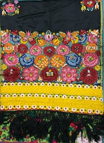 Kew Historical Society Inc
Clothing, Embroidered Silk & Cotton Apron, 1950s
The Matyó region of Hungary, which includes Mezökövesd is known for its rich costume traditions, specifically embroidery. Matyó embroidery is a densely-patterned style of free-hand work in rich and colorful floral motifs. Its prime era was the 1860s and 1870s when the folk arts thrived. This example characterizes the dynamic color combinations and flower varieties of the Matyó tradition.The textile is part of a large and significant collection of items donated by Rosemary Vaughan-Smith, past member and office-bearer of the Kew Historical Society. between 2005-12. The collection includes costumes, scrapbooks, autograph books, artworks and objects.Rectangular apron worked in three panels, the lower two of which are backed. The waist tie is of a floral fabric. The tape is attached to both vertical sides. There is a black fringe attached to the bottom panel over floral printed fabric. The needlework techniques employed in the embroidery include flat stitch which is used to create the effect of quilting and creating large brightly coloured flowers in the middle section. mezökövesd, aprons - hungarian, matyo embroidery, migration -
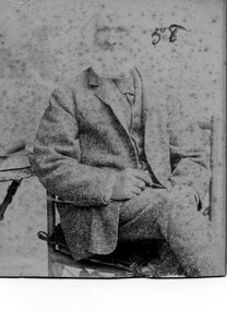 Linton and District Historical Society Inc
Photograph, Mr Henry Mercer
In the 1860s and 1870s Henry Boyd Mercer selected land between Linton and Skipton at what was then known as Spring Vale, now called Pittong. He was a successful and innovative farmer. Henry Mercer and his wife Deborah, nee Sinclair, had five children, Henry, William, Hugh, Emma and Elizabeth. Photograph is part of Old Lintonian collection ; No. 58.Sepia photograph of an old white haired bearded gentleman wearing suit, seated with legs crossed and arms on lap.henry boyd mercer, old lintonian collection -
 Kew Historical Society Inc
Photograph - Zig-Zag Bridge on the Yarra River at Kew, 1924
Henry Beater Christian (1886-1962) , was a descendant of one of the earliest settler families in Kew. Employed at the Kew Asylum as a 'public servant', he was a skilled amateur photographer, photographing numerous scenes in Kew and on his travels around Victoria. The majority of his photographs date from 1916 to 1929. His finest photographs are housed in two photograph albums. Digital copy of a photograph from page 8 of the 47-page photograph album containing 261 gelatinous silver images, loaned by Diane Washfold with permission given to digitise and hold a copy in our collection. The Zig-Zag Bridge linked the grounds of the Yarra Bend and Kew Asylums. The wooden bridge was constructed in the 1870s and lasted through numerous floods until its destruction in 1929. A horizontal structure, the walkway was reached via a wooden staircase on the Kew side. The steps were required due to the different levels of the banks on this stretch of the river. "Zig-Zag Bridge"henry beater christian (1886-1962), landscape photography, kew (vic.) — yarra river, christian-washfold collection, photograph albums, zig-zag bridge -
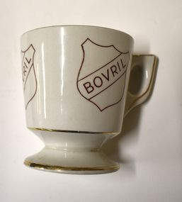 Warrnambool and District Historical Society Inc.
Domestic object - Bovril cup, c. 1950
This cup has been produced as a promotional item by the makers of Bovril, a meat extract paste usually used in cooking or stirred in hot water for a hot drink. It was developed in Britain in the 1870s and widely used during the depression of the 1930s and the World Wars when meat was scarce and expensive. Similar products such as Marmite (Britain) and Vegemite (Australia) have a vegetable rather than a meat base. This item is a memento of the times past when hot drinks made from meat or vegetable paste were very popular and it is retained for display purposes.This is a cream-coloured china cup with gold edgings and three gold-coloured Bovril logos (the name 'Bovril' inside a shield outline). The cup is mounted on a china base. Bovril Made in Englandmeat extract products, bovril, vintage china, bovril cup -
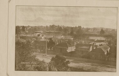 Ballarat Heritage Services
Photograph - Image, Eastern Oval from Ballarat Railway Station
The first cricket match at the Eastern Oval was held in 1853, and the first Australian Rules football match played on the ground was in 1866. W.G. Grace visited the Eastern Oval in the 1870s considering it the most English ground in Australia. The W.G. Grace Tree is located at the end of the historic grandstand. Former Australian Cricket captain Ricky Ponting has a tree planted at the oval also. Image of the Eastern Oval taken from the Ballarat Railway Station.eastern oval, eastern oval ballarat, cricket, australian rules football, w.g. grace tree, ricky ponting tree -
 Bendigo Historical Society Inc.
Document - Fortuna Bendigo, letter of re classification by the National Trust and History Brochure, 20/10/2008
The Fortuna Villa is an expansive Victorian mansion built entirely on the profits of Bendigo's lucrative gold reefs. Established by the wealthy Ballerstedt family in the 1860s, it was purchased and expanded in the 1870s by George Lansell, who was to become one of Australia's wealthiest men. Fortuna villa and gardens were once occupied and cared for by the Australia Army Survey Regiments since 1942 for over thirty years.Classification Report and Notes on the history of Fortuna from the National Trust to the Bendigo Council 20th October 2008; tourist brochure for Fortuna; it includes photographs and detailed history of George Lansell's involvement in the property and his mining history.history, national trust bendigo collection, bendigo, fortuna, george lansell, mining -
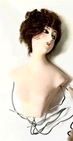 Kew Historical Society Inc
Domestic object - Tea Cosy Doll, 1900-1914
Tea cosy dolls originated in the Eighteenth Century, becoming commonplace after the 1870s. Most later Nineteenth Century examples were produced in continental European factories. These half-dolls were created using a number of mediums including soft and hard paste porcelain. They were frequently attached to a 'dressed' wire frame that covered the tea pot like a modern tea cosy.Hand-painted ceramic tea cosy half-doll with articulated arms. The half-doll has attached human hair.tea cosy top, tea cosy doll, half dolls -
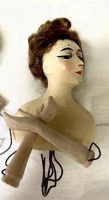 Kew Historical Society Inc
Domestic object - Tea Cosy Doll, 1900-1914
Tea cosy dolls originated in the Eighteenth Century, becoming commonplace after the 1870s. Most later Nineteenth Century examples were produced in continental European factories. These half-dolls were created using a number of mediums including soft and hard paste porcelain. They were frequently attached to a 'dressed' wire frame that covered the tea pot like a modern tea cosy. Hand-painted ceramic tea cosy half-doll with articulated arms. The half-doll has attached human hair.tea cosy top, tea cosy doll, half dolls -
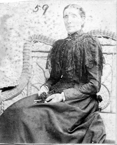 Linton and District Historical Society Inc
Photograph, Deborah Mercer, née Sinclair, c.1832-1906
Deborah Sinclair, a daughter of Jos. Sinclair and his wife Jane (née Cook), married Henry Boyd Mercer in 1859, and they had six children - Jane, Henry, William, Hugh, Emma and Elizabeth. In the 1870s Henry Boyd Mercer purchased farm land at Spring Vale (now Pittong). The property was known as "The Pines". Photograph is part of Old Lintonian Collection ; No. 59Sepia photograph of a well dressed lady seated with hands on lap. (Mounted photograph cropped to show head and shoulders only.)deborah mercer née sinclair, mrs henry boyd mercer, old lintonian collection -
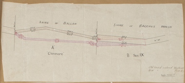 Bacchus Marsh & District Historical Society
Map, Road plan deviation near Glenmore
This plan shows a proposed deviation in the road near Glenmore. This is likely to have been the Bacchus Marsh to Ballan road. The precise date of the plan has not been established. Proposed deviations to the road near Glenmore appear in reports in the Bacchus Marsh Express newspaper through many decades, especially in the 1870s and 1880s. Glenmore is located 19 kilometers west of Bacchus Marsh.A single page paper map showing a plan for a road deviation near Glenmore Station. Scale 5 chains to 1 inch. Date of production unknown. Circa 1860s-1890s. The map is pasted into a bound volume containing 76 maps or plans in total. High resolution digital image stored on BMDHS computer network. Old road colored Yellow, New road colored Pinkroad plans, road construction, glenmore victoria maps -
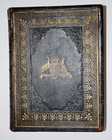 Warrnambool and District Historical Society Inc.
Book, David Blair, The History of Australasia, 1878
A history of Australasia written in late 18oo'sThe book has black leather covers which are heavily embossed with an Australian Coat of Arms and featuring gold printing, scroll work and patterns. The title of the book is on the spine which also has gold patterns. The cover is torn at the top left hand corner. The inside cover is water damaged. The gilt edged pages contain printed text, black and white and tinted illustrations and coloured maps. There is a narrow ribbon book mark , a pressed leaf and a cut out card flower inserted in the pages.non-fictionA history of Australasia written in late 18oo'saustralasian history, alice gamble, a history of australasia 1870, warrnambool -
 Warrnambool and District Historical Society Inc.
Wall Telephone, Early 20th century
Magneto wall telephones such as this one were commonly in use in Australia around the end of the 19th century and the beginning of the 20th century. The wall telephone, powered by dry cells, was an invention of the late 1870s. In the first half of the 20th century many old wall telephones were restored and put back in use by the Australian P.M.G. when there was a shortage of telephones in the 1930s Depression and during World War Two. This item, a reminder of the days of early technology, has no known local provenance but is retained for display and research purposes.This telephone piece is contained within a brown wooden box with a back board that has curved edges and extends over the edges of the box. On the back there are three metal screws for attaching the box to a wall or door. The front section of the box has curved edges with an inset panel around the edges. There is a metal turning handle on one side of the box and on the other side there is a metal clip holding a hearing piece attached to the box by a cord. On the front of the box is a speaking piece attached to the box by a metal piece. Attached to the front of the box are two semi-circular ringing pieces now situated some centimetres out from the box. The box was originally varnished but the edges are now rubbed and there are some splotches of paint. vintage wall telephones, history of warrnambool, magneto wall telephones -
 Narre Warren and District Family History Group
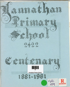
Book, Debra A Crowley, Yannathan Primary School 2422- Centenary 1881 - 1981, 1981
An account of the early history of Yannathan and the development of Yannathan School No. 2422. Lists original selectors, teachers, first committee members of the Yannathan Recreation Reserve and the Yannathan Hall. Also lists Yannathan's fallen war heroes.36 p.; 21 cmnon-fictionAn account of the early history of Yannathan and the development of Yannathan School No. 2422. Lists original selectors, teachers, first committee members of the Yannathan Recreation Reserve and the Yannathan Hall. Also lists Yannathan's fallen war heroes.yannathan (vic.), yannathan primary school no. 2422, yannathan (vic.) -- history -
 Bendigo Historical Society Inc.
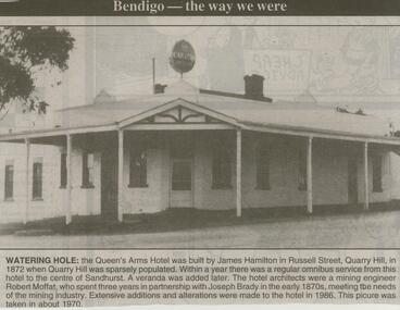
Newspaper - JENNY FOLEY COLLECTION: WATERING HOLE
Bendigo Advertiser ''The way we were'' from 2000. Watering hole: the Queen's Arms Hotel was built by James Hamilton in Russell Street, Quarry Hill, in 1872 when Quarry Hill was sparsely populated. Within a year there was a regular omnibus service from this hotel to the centre of Sandhurst. A veranda was added later. The hotel architects were a mining engineer Robert Moffat, who spent three years in partnership with Joseph Brady in the early 1870s, meeting the needs of the mining industry. Extensive additions and alterations were made to the hotel in 1986. This picture was taken in about 1970. The clip is in a folder.newspaper, bendigo advertiser, the way we were -
 Bendigo Historical Society Inc.
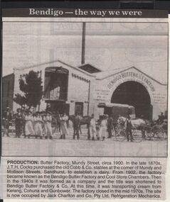
Newspaper - JENNY FOLEY COLLECTION: PRODUCTION
Bendigo Advertiser "The way we were" from 1999. Production: Butter Factory, Mundy Street, circa 1900. In the late 1870s J.T.H. Cocks purchased the old Cobb & Co. stables at the corner of Mundy and Mollison Streets, Sandhurst, to establish a dairy. From 1902, the factory became known as the Bendigo Butter Factory and Cool Store Chambers. Then in the 1940s it was formed as a company and the title shortened to Bendigo Butter Factory & Co. At this time, it was transporting cream from Kerang, Cohuna and Gunbower. The factory closed in the mid 1970s. The site is now occupied by Jack Charlton and Co. Pty Ltd, Refrigeration Mechanics.newspaper, bendigo advertiser, the way we were -
 Kew Historical Society Inc
Plan - Subdivision Plan, J R Mathers & McMillan, Myrtle Hill Estate, East Kew, circa 1949, c.1949
The Kew Historical Society's map collection includes a substantial number of real estate subdivision plans, mainly of Kew but also of surrounding suburbs in Melbourne. Most of the subdivision plans date from the 1920s and 1930s when the districts old homes and local farmland were being split up to accommodate residential growth in the postwar period. These early plans were assembled by a local firm, Jas R Mather & McMillan, which had an office in Cotham Road. Many of the plans, and sometimes photos, were annotated by the agents.Subdivision plans are historically important documents used as evidence for the growth of suburbs in Australia. They frequently provide information about when the land was sold as well as evidence relating to surveyors and real estate and financial agents. The numerous subdivision plans in the Kew Historical Society's collection represent working documents, ranging from the initial sketches made in planning a subdivision to printed plans on which auctioneers or agents listed the prices for which individual lots were sold. In a number of cases, the reverse of a subdivision plan in the collection includes a photograph of a house that was also for sale by the agent. These photographs provide significant heritage information relating house design and decoration, fencing and household gardens.The photograph may also be aesthetically significant depending on the importance of the photographic atelier.Myrtle Hill, at 14 Vista Avenue, Kew, is of local historical and architectural significance as a good example of a large and imposing single-storey Italianate house of the early 1870s surviving in Kew. Originally sited on a large allotment overlooking Normanby Road, the setting of the house has been dramatically altered through extensive subdivision and development. The subdivision plan of the ‘Myrtle Hill Estate’ indicates that in one such subdivision, 11 allotments were created fronting Bowyer Avenue, Myrtle Avenue, and Normanby Road. The outline and building profile of Myrtle Hill is shown on the west side of Bowyer Avenue.The full (typed) title of this subdivision plan is :"Plan of SUBDIVISION of part of CROWN PORTION 83. / at KEW / PARISH OF BOROONDARA. / COUNTY OF BOURKE". / "MYRTLE HILL ESTATE / EAST KEW" In addition to the Title and subtitle, the plan also lists the advantages of the subdivision. -
 Kew Historical Society Inc
Photograph - Zig-Zag Bridge, 1924
Henry Beater Christian (1886-1962) , was a descendant of one of the earliest settler families in Kew. Employed at the Kew Asylum as a 'public servant', he was a skilled amateur photographer, photographing numerous scenes in Kew and on his travels around Victoria. The majority of his photographs date from 1916 to 1929. His finest photographs are housed in two photograph albums. Digital copy of a photograph from page 8 of the 47-page photograph album containing 261 gelatinous silver images, loaned by Diane Washfold with permission given to digitise and hold a copy in our collection. The Zig-Zag Bridge linked the grounds of the Yarra Bend and Kew Asylums. The wooden bridge was constructed in the 1870s and lasted through numerous floods until its destruction in 1929. A horizontal structure, the walkway was reached via a wooden staircase. The steps were requires due to the different levels of the banks on this stretch of the river. The photo is taken from the Kew side of the river. "Zig-Zag Bridge"henry beater christian (1886-1962), landscape photography, kew (vic.) — yarra river, christian-washfold collection, photograph albums, zig-zag bridge -
 Warrnambool and District Historical Society Inc.
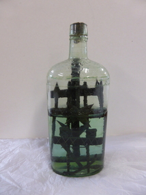
Bottle, Chinese puzzle, 19th century
This item, always known as a ‘Chinese Puzzle,’ has been in the collection of the Warrnambool and District Historical Society for many years. It is such an oddity that it is probable that it came from the collection of the old Warrnambool Museum which was established in the 1870s-80s and was dismantled in the 1960s. It had many objects of a bizarre nature such as this as many local people while on their travels brought back from many different countries objects deemed to be of unusual interest. This item is of great interest as an oddity from the 19th century and it attracts great attention when it is displayed. This is a spherical-shaped imperial quart thick glass bottle with a cork in the top. It contains a clear liquid filling two-thirds of the bottle. Inside the bottle and filling it to the top of its main section are several pieces of metal of varying shapes. These originally were part of a puzzle, presumably with the object being to unlock the shapes from each other. These have now been connected to each other with what looks like thin wire. The liquid is still reasonably clear. The cork is a little worn at the top. ‘Imperial Quart’chinese puzzle, warrnambool -
Warrnambool and District Historical Society Inc.
Publication, Collett and Bain, Heytesbury Forest School, c.1971
This booklet, by Rosamund Duruz, gives the history of the schools in the Heytesbury Forest area. The Heytesbury Shire Council was established in 1863 and the first schools in the area opened in the 1870s. Most of them were closed when Timboon Consolidated School (later Timboon High School) opened in 1948. The Heytesbury Forest was largely deforested by the Bailey Closer Settlement Scheme of the 1930s and later the establishment of more farming properties in the 1950s. This booklet is of interest as a comprehensive history of the schools in the Heytesbury Forest area pre 1970. It will be useful for researchers. This is a soft-cover booklet of 63 pages. The cover is a cream colour with brown images of trees and a school on the front cover. The booklet includes a map, a sketch and several black and white photographs. The booklet is bound with metal staples.schools in heytesbury forest, victoria, rosamund duruz, historian, history of warrnambool -
 Greensborough Historical Society
Photograph, Willis Vale 1906, taken from the hill, 1906_
'Willis Vale' home of the Partington family is shown in this photograph as well as the area now known as Partington's Flat. The area was owned and farmed by the Partington family from the 1870s. The derelict Willis Vale house was destroyed in 1964 when a fire originating from North Plenty Gorge - Kurrak Road - lit by two teenage boys - made its way several kilometres down to Partington's Flat Greensborough.Photograph shows an early view of Greensborough in 1906.Professional photograph in sepia mounted on dark green card. Shows Greensborough township in background with Willis Vale homestead in centre. On back: A.M.Partington Greensborough 1906.willis vale, partington family, greensborough, alan partington -
 Bacchus Marsh & District Historical Society
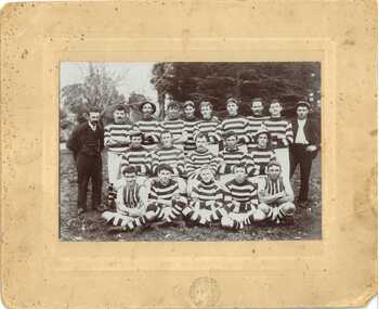
Photograph, A.E. Beseler, Parwan Football Club
Parwan Football Club was formed in May 1912. The specific date of this photo is not given, but it is likely that it was taken between 1912 and 1914, when the football competition was suspended. This photo is one of the oldest known photographic records of an Australian Rules football team in the Bacchus Marsh area. Australian Rules football was played in this area as early as the 1870s. An organized competition to play regular matches was formed in the early years of the twentieth century. This item has historic and social significance as an image of one of the early sporting teams of Bacchus Marsh and district. It is a typical example of team photographs of this era. It is evidence of the transition of football from a social informal setting to an organised activity and signals the growth of importance of sport, in this case Australian Rules football, as a cultural and social activity central to the Australian ethos. A sepia photograph print mounted on mounting board, showing a group of 20 men arranged in three rows. Two men, standing at either end of the group, are wearing street clothes. The remaining men are wearing a uniform of striped guernseys, white knickerbockers, knee high socks and lace up boots. Two of the men are wearing front-laced guernseys. Three are wearing striped caps, which could be part of the uniform, two a flat cap and two are wearing brimmed hats. There is a consistency in the uniform they are wearing, indicating that team sport is becoming more organised.On the front, a circular professional stamp reading: PHOTO ARTIST BACCHUS MARSH. A. BESELER. On the reverse: A white paper rectangle pasted onto the board, with hand-written notations: Back - with numbers 1-10. Against no.1 Doherty. Against no. 3 Dodemaide. Middle_ numbers 1-5. Front_ numbers 1-5. Under the paper, hand-written in blue ink: PARWAN FOOTBALL CLUBaustralian rules football, parwan football club -
 Tarnagulla History Archive
Photograph of Calder's Shed, Tarnagulla, Calder's Shed, Tarnagulla, late 1960s
Murray Comrie Collection. The building depicted was previously used for Barnes' Store at Waanyarra, later relocated to Tarnagulla. William Barnes was a tailor at Tarnagulla and Waanyarra in the 1860s. By the late 1870s the family was living at Grassy Flat. The building was located on the south-eastern corner of the Gladstone-Victoria Street intersection, and for many years housed the chaff-cutting operations of the Calder family. The building gradually fell into disrepair, and was completely dismantled in the 1990s. Monochrome photograph depicting part of a building, known as Calder's Shed in Gladstone St, Tarnagulla This dark, poor quality photograph was probably taken in the late 1960s. tarnagulla, waanyarra, buildings, calder, barnes, shed, stores -
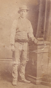 The Beechworth Burke Museum
Photograph - Carte de Visite, James Bray, 1870
This photograph was taken in c.1870 and depicts Aaron Sherrtt who is best known for his involvements with, and eventual assassination by, the Kelly gang. He stands upright in the image with his arm leaning on a podium which reaches his hip. He is wearing an outfit for which he was infamous. Richard Warren, son of the proprietor of the Ovens and Murray Advertiser once stated that “anyone seeing [Aaron] coming down Ford Street would ask, “Who the hell’s this? Some advance agent for the circus?”’. The outfit Aaron wore for this particular photoshoot is reminiscent of this quote. He wears an unusual spotted shirt with a waistcoat and a sash is tied at his waist. He wears boots which turn up slightly at the toes. The hat is a “pork pie” hat which is worn in the typical “Greta Mob” style with the chinstrap under the nose. Aaron Sherritt was born in 1854 in Prahran, Melbourne, to Irish Protestant parents John and Anne. Sherritt stood at 5 foot 10. He had hazel eyes, dark brown hair and pale olive skin. Sherritt was childhood friends with Kelly Gang member, Joe Byrne, having previously attended the same school. Both men had a reputation for stealing horses and on one occasion, after stealing and butchering a cow, Sherritt and Byrne were convicted to six months in Beechworth Gaol (1876). Sherritt, along with Byrne, were reportedly recruited by Ned Kelly in 1877 in stealing stock; however, Sherritt never became a fully-fledged member of the Kelly Gang. Nevertheless, Sherritt scouted for the Kelly Gang in 1878. He later struck a deal with the police (specifically, with Chief Commissioner Standish) to save Joe Byrne's life in exchange for leading the police to the other members of the Gang. From then on, Aaron Sherritt lived the dangerous life of a double agent, providing police with what is assumed today to have been outdated or incorrect information in return for money. On the 26th of June 1880, Aaron Sherritt was murdered in the Woolshed Valley. He was approximately 23-25 years old at death. This event marked the start of the Kelly gang’s last days. Sherritt was murdered by Byrne in front of his wife, 15 year old and heavily pregnant Ellen “Belle” Sherritt and her mother Ellen Barry. Also in the Sherritt dwelling on this particular night were four policemen. The intention behind Sherritt’s murder was for the police to send word to Melbourne that the Kelly gang had murdered Sherritt and a police train would be sent to Glenrowan where the rest of the Kelly gang were waiting. This plan did not go as predicted and ultimately the Kelly gang fell at Glenrowan in 1880. This photograph was taken by James Bray who worked as a professional photographer in Camp Street Beechworth from 1870-1891. He was one of four men who photographed the Kelly Gang after the siege in Glenrowan in 1880. He is also renowned for his previous work photographing members of the Kelly gang. This photograph is part of the Burke Museum "Kelly album" which includes a significant collection of photographs and artefacts connected to Ned Kelly and the Kelly Gang. Ned Kelly and his gang have become ingrained in Australian popular culture and thus many museums, art galleries and private collections house material connected to the Kelly story which allows the events and people to be researched and interpreted. Artefacts and photographs pertaining to the Kelly gang are particularly valuable for Australian museums. This particular photograph is significant for its connection to Beechworth photographer James Bray who is responsible for many images depicting members of the Kelly Gang. The photograph is also of artistic significance as an example of a Carte de Viste dating to 1880 and it's connection to Aaron Sherritt.Sepia rectangular photograph printed on card. Obverse: J.E.Bray./ Photo/ Beechworth Reverse: Portrait & Landscape/ Photographer 5/ Aaron Sherritt J E Bray Signature Beechworth/ Victoria Beware (almost erased out) Negatives Kept. Copies 5I/.Each May/ Be Had By Forwarding Name And Address/ Accompanied With Remittance To/ The Amount Of Order/ Photographs Coloured In Water Colours 10237. kelly album, woolshed valley, 1870s, kelly gang, joe byrne, ned kelly, aaron sherritt, james bray, beechworth, burke museum -
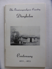 Warrnambool and District Historical Society Inc.
Booklet, The Temiangandeen Country Dergholm, 1973
This booklet gives information on the settlement of Dergholm at the time of the centenary of its founding, 1973. The origin of the name Dergholm is unclear but it may have Irish connections. Europeans came to the area in the 1840s and 50s but it was not until the 1870s that the town was surveyed. Dergholm is in the far west of Victoria 334 kilometres from Melbourne and nearby is Dergholm State Park established in 1982. The booklet was produced for the Centenary Back to Dergholm Committee and the local centenary celebrations. This book is of some interest as it provides information on Dergholm, a settlement in the far west of Western Victoria. This is a soft cover booklet of 52 pages by Alistair Roper. It has a cream-coloured cover with a black and white photograph of early Dergholm on the front cover (Edward Quinn’s house). The booklet has printed material - a President’s Message, an Author’s Note, Acknowledgements, Contents, information on the Dergholm area, including a list of local birds, and References. There are several black and white photographs of the area and its people. The book is stapled. Front Cover: ‘The Temiangandgeen Country, Dergholm Centenary, 1873-1973’dergholm victoria, alistair roper, history of western district of victoria -
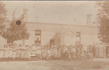 Sunbury Family History and Heritage Society Inc.
Photograph, Sunbury State School
The first building which housed Sunbury State School No.1002 was built on the corner of Macedon and Stawell Streets in the early 1870s and functioned as the local State School until 1912 when a sturdier red brick structure replaced on the same site. In 1999 Sunbury State School was relocated in the former Industrial School heritage buildings in Jacksons Hill. The existing building in Macedon Street was incorporated into the Sunbury Community Health Centre. The school in the photograph is the original Sunbury State School NO. 1002 building, where many early Sunbury residents attended. A non-digital black and white photograph in post card format of a crowd of children outside a school building. Four teachers are standing on the RHS of the image.sunbury state school no. 1002, stawell street, macedon street, schools -
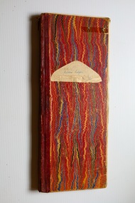 Warrnambool and District Historical Society Inc.
Administrative record - Debtors' Ledger, early 20th century
This ledger contains details of debts owed by people in the Warrnambool district. It dates from 1906 to 1916. The compiler of the ledger is unknown. Many of the debtors are Chinese, mostly working as market gardeners in the north Warrnambool area and the debts usually concerned rents and the supply of agricultural items such as chaff. These Chinese, many of whom came from the Victorian goldfields, operated market gardens and businesses in the town of Warrnambool from the 1870s to the 1930s or 40s.This ledger is of interest because of the names of people listed as debtors and in particular the names of Chinese working in the district. The ledger is thus a valuable research tool. This is a ledger with a thick card cover in a mottled pattern in red, black, blue and yellow colours The spine, which has some damage, is covered in a maroon coloured leather. The pages are ruled with red lines and the entries are handwritten in ink. There are some loose pages.Debtor's Ledger C.L.warrnambool chinese market gardeners, warrnambool, chinese