Showing 1066 items matching "boundary"
-
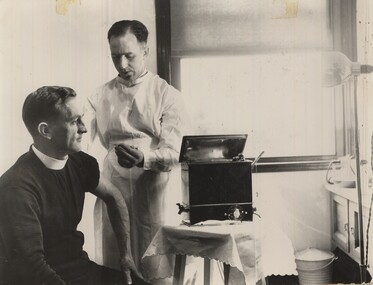 St Patrick's Old Collegians Association (SPOCA)
Photograph - Teachers, Jesuits
-
 City of Moorabbin Historical Society (Operating the Box Cottage Museum)
Photograph - Map of Dendy's Special Survey, 1852 Map of Henry Dendy's Special Survey of 1841, 19th Century
A Map drawn in 1852 that shows the 5,120 acres that formed Dendy's Special Survey of 1841. In 1840 Henry Dendy, a farmer in Surrey, England acquired a "Special Survey" from the Commissioners for Land and Emigration which gave Dendy the right to choose land in Port Phillip for the "bargain basement" price of only £1 per acre for 5120 acres, (an area of 8 square miles). The Special Survey also included the right to "the shipment of a worker for every £20 spent on land, whose free passage was paid by the Crown, equalling a total of 100 workers ". Accordingly Dendy sold his English holdings and paid the required £5120 and arrived in Melbourne in February 1841. However by this time land in the new colony was selling for £5 - £40 per acre. Because Henry Dendy possessed the order from the Colonial Office in London he was able to successfully oppose Governor LaTrobe's attempts to alter the price of the land. Dendy appointed Jonathan Were, (an entrepreneur, who had arrived in 1839), as his Manager and who later became a partner. Together, Dendy and Were decided on an area 5 miles south from Melbourne, bounded by North Road, East Boundary Road, South Road and to the west by Port Phillip Bay. Were and Dendy pitched their tents in the area now known as ' Park St, Brighton' and sank a well near the corner of 'St Andrew's St and Wells St'. By 1845 J.B Were and Company had bought almost half of Dendy's land and Were built himself "Moorabbin House" in Were St Brighton made from stone, quarried from local cliffs. It was still standing in 1924. Legend records Moorabbin is named after the Aboriginal word for ' Mother's Milk ' The soil is very fertile and well supplied with water especially in the area called 'East Brighton' - now known as Bentleigh and East Bentleigh - By 1850 the area had developed with numerous market gardens, dairy farms, fruit gardens and vineyards supplying food for the growing population of Melbourne.This Map shows the birth of the Brighton and Moorabbin area. On 18th January1859 Brighton was proclaimed a Municipality and a Borough by October 1863. Meanwhile, following a Petition, the area of East and South Brighton, incorporating Mordialloc, Cheltenham, Mentone, Sandringham and Oakleigh separated from Brighton to form the Moorabbin District Roads Board becoming the first Local Government Authority. Col. William Mair was elected as the first Chairman of the Moorabbin Roads Board. Moorabbin Shire 1871 developed further and was declared a City in1934. The City of Moorabbin was the largest Municipality in Melbourne before the Amalgamation of Councils in 1994 when it was divided in the south to City of Kingston and in the north to City of Glen Eira A Photo-lithographed 1852 Map showing the 5,120 acres that formed Dendy's Special Survey of 1841. Henry Dendy & Jonathan Were chose an area 5 miles south from Melbourne, bounded by North Road, East Boundary Road, South Road and to the west by Port Phillip Bay. Moorabbin County of Bourke / Photo-Lithographed at the department of Lands and Survey. /Melbourne. / Price 1/- brighton, moorabbin, bentleigh, cheltenham, dendy henry, bent thomas, were jonathan, special survey -
 Ringwood and District Historical Society
Document - Folder, Land Sale - Monterey Park Subdivision, Warrandyte Road, Ringwood North, Vic. - 1981
Foolscap manilla folder containing double-sided flyer advertising residential subdivision development, including outline of local facilities and services, with locality map and layout of Monterey Park streets. Subdivision includes Parkwood High School, Tortice Drive, Heape Way, Appleberry Place, Stringybark Court, Conifer Court, Crawley Grove, Monterey Close (later Monterey Place), Lucy Place, Middlebrook Drive, Gahnia Close, Glanfield Court, Cone Close, Jull Parade, Pinus Close (later Pinetree Court), Radiata Close, Old Warrandyte Road, and entry from Warrandyte Road. Vendor - Jennings Industries Limited, 690 Springvale Road, Mulgrave, 3170, Phone 5618000. A4 enclosures with tables showing each allotment List Price, Builders Price, Cash Price and Terms Price. Information page headed "Form of Restrictive Covenant to be incorporated in Transfer" specific to Certificates of Title. Restrictive Covenant (summary): (Name/s) "... will not erect or construct or cause to be erected or constructed on the land hereby transferred (a) Any front boundary fence, other than a fence which does not exceed one metre in height unless the same is set back as least 1.5 metres from the front boundary and the same is effectively screened from that boundary by the planting of trees, shrubs or plants. (b) Any side boundary fence other than a fence which is set back at least 1.5 metres from the front boundary on which does not exceed 1 metre in height within 1.5 metres of the front boundary. (c) For a period of 5 years from the date hereof, any building on the said land unless and until the Plans and Specifications thereof have first been approved by the said Residential Developments Pty. Limited. (d) For a period of 2 years from the date hereof whilst the said land remains vacant any Signboard or Notice advertising the sale of the said lot or any other lot. These covenants shall appear on the Certificate of Title to issue for the said land and run with the land." -
 University of Melbourne, Burnley Campus Archives
Plan, Royal Horticultural Society's Garden
Changed boundaries of the site burnley gardens, survey paddock, flood, lynch design, richmond park, yarra river -
 Greensborough Historical Society
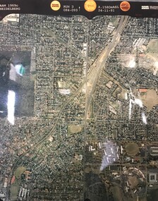
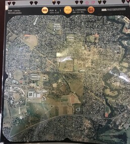
Aerial Photograph, AAM Photographics, Heidelberg AAM1969c 084, 24/11/1991
One of an overlapping series of aerial photographs of the Heidelberg/Greensborough areas, covering Greensborough, Macleod, Viewbank & Yallambie. North boundary Nell Street, South boundary Simpson BarracksLaminated colour aerial photographgreensborough, viewbank, yallambie -
 Coal Creek Community Park & Museum
Mine Map
6306.1 - Map of Outtrim mining area, with modification where damage/erasure has occurred. Shows tunnels, faults, tramways, boreholes, surface roads and (apparently) paddock boundaries and a creek. -
 Bendigo Historical Society Inc.
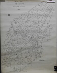
Map - JACK FLYNN COLLECTION: BENDIGO, Revised 1/01/1961
Map: Bendigo city, it has City of Bendigo Planning Scheme as the title. Showing the city within the Municipal Boundaries, also has contour lines and the Major Gullies. Revised 1.1.1962.map, bendigo, city streets, bendigo planning scheme -
Tatura Irrigation & Wartime Camps Museum
Drawing - Sketch, Tatura Camp 1
Herman Bernhard SCHMIDT was a foundry owner in Queensland. He was interned and sent to Gaythorne internment camp for 6 months and then sent to Tatura Camp 1 until 1946 when he was released.Black and white sketch Camp 1 Tatura showing boundary of camp and location of huts. Framed in a dark coloured wood and under glass. Has a light plum coloured mount.label on back "Donated by the Gunther Schmidt Family Trust" (son of Herman Bernhard Schmidt - Tatura WW2) March 2023herman bernhard schmidt, queensland foundry owner, camp 1 tatura, gunther schmidt trust, gaythorne camp queensland -
 Whitehorse Historical Society Inc.
Document, Landscape Submission, c 1976
A landscape submission written for the National Trust of Australia (Victoria) for Blackburn Lake and the Bell Bird Streets.A landscape submission written for the National Trust of Australia (Victoria) for Blackburn Lake and the Bell Bird Streets. Definitions given of boundaries of the Lake area, ownership, housing and gardens. Photographs and map.A landscape submission written for the National Trust of Australia (Victoria) for Blackburn Lake and the Bell Bird Streets.blackburn lake sanctuary, waratah crescent, blackburn, jeffery street, hill street, boongarry avenue, linum street, laurel grove, acacia avenue, city of nunawading, melbourne and metropolitan board of works, furness park, camberwell grammar school -
 Ringwood and District Historical Society
Newspaper, Scrapbook Clipping, Library Collection, Ringwood, Victoria
Newspaper Clipping from the "Mail", 03-09-1996. P5. Yes to seven wardsMaroondah Council's recently announced ward boundaries have been published in the Government Gazette. Each of the seven was approved by Local Government Minister Rob Maclellan -
 Kew Historical Society Inc
Plan, Melbourne & Metropolitan Board of Works : Borough of Kew : Detail Plan No.1591, 1905
The Melbourne and Metropolitan Board of Works (MMBW) plans were produced from the 1890s to the 1950s. They were crucial to the design and development of Melbourne's sewerage and drainage system. The plans, at a scale of 40 feet to 1 inch (1:480), provide a detailed historical record of Melbourne streetscapes and environmental features. Each plan covers one or two street blocks (roughly six streets), showing details of buildings, including garden layouts and ownership boundaries, and features such as laneways, drains, bridges, parks, municipal boundaries and other prominent landmarks as they existed at the time each plan was produced. (Source: State Library of Victoria)This plan forms part of a large group of MMBW plans and maps that was donated to the Society by the Mr Poulter, City Engineer of the City of Kew in 1989. Within this collection, thirty-five hand-coloured plans, backed with linen, are of statewide significance as they include annotations that provide details of construction materials used in buildings in the first decade of the 20th century as well as additional information about land ownership and usage. The copies in the Public Record Office Victoria and the State Library of Victoria are monochrome versions which do not denote building materials so that the maps in this collection are invaluable and unique tools for researchers and heritage consultants. A number of the plans are not held in the collection of the State Library of Victoria so they have the additional attribute of rarity.Original survey plan, issued by the MMBW to a contractor with responsibility for constructing sewers in the area identified on the plan within the Borough of Kew. The plan was at some stage hand-coloured, possibly by the contractor, but more likely by officers working in the Engineering Department of the Borough and later Town, then City of Kew. The hand-coloured sections of buildings on the plan were used to denote masonry or brick constructions (pink), weatherboard constructions (yellow), and public buildings (grey). That area of Kew bordered by Cotham Road, Park Hill Road, Ermington Lane (now Ermington Place), and Belmont Avenue contained some of the significant homes owned by Kew pioneers. Chief among these was ‘Park Hill’ on an enormous lot facing Park Hill Road. The Jubilee History of 1910 noted, six years after this plan was drawn, that: ‘Park Hill Road, forming the southern boundary of the cemetery, takes its name from Park Hill, the residence of Mr. Thomas Judd, who has resided there since December, 1852.’ Other named houses on the plan include ‘Ferndale’ facing Cotham Road; ‘Ermington’ adjacent to Judd’s Park Hill, facing Park Hill Road; and ‘Gilden’ and ‘Mont Belmont’ facing Belmont Avenue. Mont Belmont was designed by the architectural firm of Reed, Henderson and Smart for William George Lilley in 1887 and was completed in 1888. Lilley was Mayor of Kew in 1887-88, a Justice of the Peace and a member of the first Board of Guardians of Kew’s St. Hilary’s Church of England.melbourne and metropolitan board of works, detail plans, survey plans - borough of kew, mmbw 1591, cartography -
 Coal Creek Community Park & Museum
Mine Map
8518.1 - Unlabelled map of mining tunnels, coal seams, boreholes, creeks, roads and (presumably) paddock boundaries. Based on features in common with other maps, very likely map of Korumburra area. -
 Tatura Irrigation & Wartime Camps Museum
Photograph, 1946
Might be Bill Baker (extreme right). Could be the Tatura side.Black and white photograph of the footy team 18 plus the boundary umpire holding the Sherrin, laces out. 7 standing, 1 row of 6 kneeling and 1 row of 6 sitting. camp 13, camp football games, bill baker -
 Whitehorse Historical Society Inc.
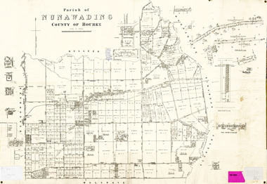
Legal record - Map, Parish of Nunawading, c1930
Office of Lands and survey map, 1864 with many further subdivisions of 1870 onwards added.Office of Lands and survey map, 1864 with many further subdivisions of 1870 onwards added. Boundaries of City of Box Hill included. Note added re Slater's land in Blackburn North. Office of Lands and survey map, 1864 with many further subdivisions of 1870 onwards added. maps, shire of blackburn and mitcham, city of box hill, slater family -
 Whitehorse Historical Society Inc.
Article, Council votes 'no' to triennial elections, 1990
Council decisions not to switch to triennial elections was influenced by August '89 electionCouncil decisions not to switch to triennial elections was influenced by August '89 election in which all councillors forced reelection due to boundary changes. Council received $30,000 as local government grant.Council decisions not to switch to triennial elections was influenced by August '89 electioncity of nunawading, elections. -
Whitehorse Historical Society Inc.
Article, Contribution will continue, 17/07/1996 12:00:00 AM
Retirement from politics following redistribution of electoral boundaries in 1990-91. Mr Cox given a dinner attended by Liberal Party members and friends. Inaugural member of Schwerkolt Management Committee.Retirement from politics following redistribution of electoral boundaries in 1990-91. Mr Cox given a dinner attended by Liberal Party members and friends. Inaugural member of Schwerkolt Management Committee.Retirement from politics following redistribution of electoral boundaries in 1990-91. Mr Cox given a dinner attended by Liberal Party members and friends. Inaugural member of Schwerkolt Management Committee.parliamentary representatives, cox, george -
Canterbury History Group
Document - Deed between the Mayor, Councillors and the Citizens of Camberwell and the Canterbury Bowling Club, 1955
Deed allowing the Canterbury Bowling Club the right to occupy land adjacent to the southern boundary of the bowling green, subject to conditions as set out on the Deed between the club and rhe City of Camberwellcanterbury, canterbury bowling club, kendall street, lawn bowls, city of camberwell, goble> george, maclean> george, etherington> arthur, maps, legal documents -
Port Melbourne Historical & Preservation Society
Map - MMBW, c. 1894
Melbourne and Metropolitan Board of Works 1894, Plan number 18 Segments Shown: Between 322 - 486 Smaller scale map incorporating piers, lagoon and town north to beyond boundaryIn pencil: "7/7/94" (Which is the copyright date)engineering - board of works, piers and wharves - railway pier, piers and wharves - town pier, sandridge lagoon, transport - tramways, transport - railways, gasworks, built environment -
 Lakes Entrance Historical Society
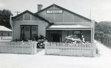
Postcard - Venga Guesthouse, Bulmer H D, 1945c
Enlargement of same photo 28 cm x 35 cmBlack and white postcard of Venga Guest House, Lakes Entrance, Victoria, showing weatherboard clad building, gable roof, veranda across half front, picket fence on Esplanade boundary.guesthouses, architecture, fences -
 Bayside Gallery - Bayside City Council Art & Heritage Collection
Map, H.B. Foot, Plan of the Brighton Estate containing 5120 acres, first special survey at Port Phillip, c. 1842
This plan records the Brighton Estate, also known as Dendy's Special Survey. In 1840 Henry Dendy, a farmer in Surrey, England acquired a "Special Survey" from the Commissioners for Land and Emigration which gave him the right to choose land in Port Phillip for the low price of £1 per acre for 5120 acres. Dendy appointed Jonathan Binns Were, as his agent, who later became a partner. Together, Dendy and Were decided on an area 5 miles south from Melbourne, bounded by North Road, East Boundary Road, South Road and to the west by Port Phillip Bay. Their Brighton Estate was first surveyed by T. S. Townsend in May 1841 and was re-surveyed by Robert Hoddle. Dendy and Were were making plans to sell the land and advertised a 30-guinea prize for the best subdivision which was to be divided into a village, marine residences, suburban and cultivation allotments, with the remainder being divided into country sections. The competition was won by H.B. Foot, who planned the village around a reserve and crescents and a 'green belt' forming the town boundary. brighton estate, dendy's special survey, special survey, henry dendy, jonathan binns were, w.b. were, survey, plan, map, brighton, george ward cole, baker's lithographer, hibernian, subdivision, town planning, cartographic material, h.b. foot -
 Greensborough Historical Society
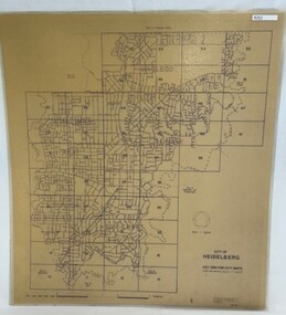
Poster - Map, City of Heidelberg, 1984
Numbered grid map of the City of Heidelberg showing municipal boundaries in 1984 . Scale 1 inch to 160 feet. Side 2: MMBW Plans Yarra 2000, note Ward boundaries not updated on this plan.An example of hard copy plans from the 1960s. Mainly from the Shire of Diamond Valley era (1964-1994).Map printed on brown paper and laminated. Double sided.city of heidelberg, mmbw -
 Greensborough Historical Society
Aerial Photograph, AAM Photographics, Heidelberg AAM1969c 086, 24/11/1991
One of a series of four overlapping aerial photographs of the Heidelberg/Greensborough areas in 1991, covering Simpson Barracks, Macleod, Rosanna, Viewbank, Watsonia & Yallambie. North boundary Yallambie Road; West boundary Hurstbridge railway.Laminated colour aerial photographssimpson barracks, yallambie, watsonia, macleod, rosanna, viewbank -
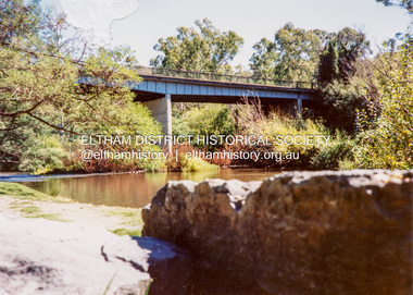 Eltham District Historical Society Inc
Photograph - Colour Print, Warrandyte Bridge over Yarra River, c.1987
Boundary for the Shire of Eltham and now Shire of Nillumbikwarrandyte bridge, yarra river -
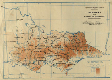 Federation University Historical Collection
Map, Victoria: Regions for Planning and Development, 1944, 1944
This map was produced for the State Regional Boundaries Committee Two colour map of Victoria showing the regions for planning and development. The regions are Central Highlands, Mallee, Wimmera, Glenelg, Corangamite, Barwon, Loddon, Goulburn, Upper Goulburn, Upper Murray, East Gippsland, West Gippsland, Port Phillip.central highlands, mallee, wimmera, glenelg, corangamite, barwon, loddon, goulburn, upper goulburn, upper murray, east gippsland, west gippsland, port phillip, victoria, m4486 -
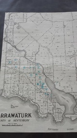 Peterborough History Group
Map - Map of Curdies River Inlet district, Narrawaturk
Shows the allotment boundaries and names of landowners at the timeSignificant as it shows owners of rural land in the Peterborough area.Photocopy of an old mapHandwritten notes and markings on the map.peterborough, curdies river, curdies river inlet, old maps, maps, narrawaturk -
 Greensborough Historical Society
Certificate of Title, Supreme Court of Victoria (Probate Division) et al, Certificate of Title Vol. 2567 Fol. 294, Vol. 3134 Fol. 605, 22/05/1895
Title Vol. 2567 Fol. 294 in the name of The Greensborough Estate Company Limited, 164 acres four and a half perches, being part of Crown Portion 17 Parish of Keelbundora, County of Bourke. Dated 22nd May 1895. Northern boundary Greensborough Road (now Grimshaw Street), Southern boundary Nell Street, Eastern boundary Plenty River, Western boundary road (now named McDowell Street); Title Vol. 3134 Fol. 605 in the name of Adolphe Frederic Seelenmeyer, land as described above, LP 4759 and transfers and other instruments to 9 March 1948Folder containing two Certificates of Title (3p. + 9 p.) and twenty pages of miscellaneous documents, including historical summary, brief biography of A. F. Seelenmeyer, two Death Certificates and photocopied extracts from probate documents, as listed in table of contents, ed. by Peter Simmenauergreensborough, greensborough estate company limited, grimshaw street greensborough, plenty river, nell street greensborough, mcdowell street greensborough, adolphe frederic seeley, formerly seelenmeyer, adolfe frederic seelenmeyer -
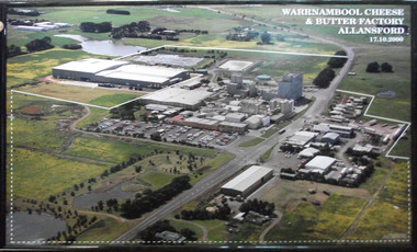 Cheese World Museum
Photograph, Warrnambool Cheese and Butter Factory Co Ltd site 2000 -aerial view, 2000
Warrnambool Cheese and Butter Factory Company was formed by a group of Warrnambool business men. The company was registered in May 1888 and commenced commercial production in November 1888. The company retained its independence for more than 125 years until acquired by Canadian firm Saputo. It has operated from the same site since its inception and also has an office in Japan. Milk processing is undertaken by Sungold. Milk powder for export is also produced on-site. Cheese World is a retail arm of the company operates on a connected site selling company products, local food products, wine and cheese tasting. Cheese World Museum operates under the Cheese World umbrella.Aerial colour photograph of Warrnambool Cheese and Butter Factory in wooden frame. Shows buildings and surrounds. Lines indicate factory boundaries, dotted lines indicate property extension. Date is recorded on the image.17.10.2000allansford, warrnambool cheese and butter factory company, saputo, dairyiing, dairy manufacturing, diary manufacturers, cheese, butter -
Port Melbourne Historical & Preservation Society
Document - Electoral Roll, City of Port Melbourne, City of Port Melbourne, Voters' Rolls, 10 Jul 1986
Prepared by the Town Clerk's Office of the City of Port Melbourne. Voters' roll for 1987 in the electoral province of Melbourne, divided according to Port Melbourne Division, Municipal Wards, and certified by Fred. C. Jackson, Town Clerk. This volume with pink cover, Boundary Ward.politics, local government - city of port melbourne, town clerks, frederick charles jackson -
Port Melbourne Historical & Preservation Society
Document - Specification, Metalling and chanelling, Boundary Street South, Graham Street to St Vincents Street, Arthur Victor Heath, Town Clerk et al, 14 Mar 1893
Specifications (Reg. 77.1) and plan (Reg 77.2) for metalling and channelling Boundary Street South [Pickles Street] from Graham Street to St. Vincents Street. Loan works 1893, plan No. 5.A.V. Heath (Town Surveyor):J.J. Bartlett (Mayor)engineering - roads streets lanes and footpaths, town planning, town clerks, mayors, arthur victor heath, james john bartlett -
Port Melbourne Historical & Preservation Society
Plan - Metalling and chanelling, Boundary Street South, Graham Street to St Vincents Street, 14 Mar 1893
Specifications (Reg. 77.1) and plan (Reg 77.2) for metalling and channelling Boundary Street South [Pickles Street] from Graham Street to St. Vincents Street. Loan works 1893, plan No. 5.J.J. Bartlett (Mayor) 14/3/93engineering - roads streets lanes and footpaths, town planning, town clerks, mayors, arthur victor heath, james john bartlett