Showing 749 items
matching contractor
-
 Eltham District Historical Society Inc
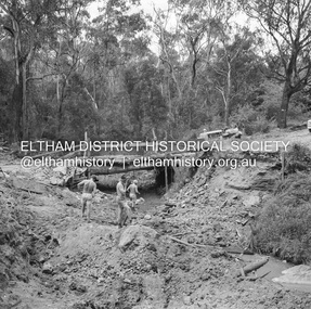
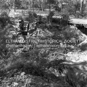
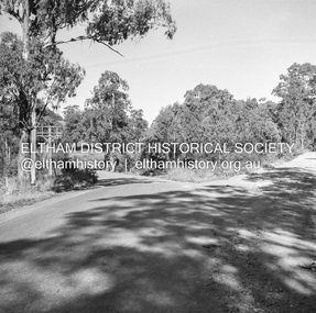
Negative - Photograph, J.A. McDonald, Heidelberg-Kinglake Road, 3 Nov. 1959
Job 56M431 Contractors Wolf and Wood Yow Yow Creek Bridge Old bridge cut Temporary bridge in use 3 November 1959Record of various Shire of Eltham infrastructure works undertaken during the period of 1952-1962 involving bridge and road reconstruction projects, sometimes with Eltham Shire Council Project Reference numbers quoted. It was during this period that a number of significant improvements were made to roads and new bridges constructed within the shire that remain in place as of present day (2022). In many situations, the photos provide a tangible visible record of infrastructure that existed throughout the early days of the Shire. The album was put together by or under the direction of the Shire Engineer, J.A. McDonald.infrastructure, shire of eltham, bridge construction, heidelberg-kinglake road, road construction, yow yow creek, 1959-11-03 -
 Eltham District Historical Society Inc
Negative - Photograph, J.A. McDonald, Heidelberg-Kinglake Road, Mar. 1960
Cherry Tree Road Job 56F443 Contractors Wolf and Wood Old bridge and stream clearing during construction of new bridge March 1960Record of various Shire of Eltham infrastructure works undertaken during the period of 1952-1962 involving bridge and road reconstruction projects, sometimes with Eltham Shire Council Project Reference numbers quoted. It was during this period that a number of significant improvements were made to roads and new bridges constructed within the shire that remain in place as of present day (2022). In many situations, the photos provide a tangible visible record of infrastructure that existed throughout the early days of the Shire. The album was put together by or under the direction of the Shire Engineer, J.A. McDonald.infrastructure, 1960-03, bridge construction, cherry tree road, heidelberg-kinglake road, road construction, shire of eltham -
 Eltham District Historical Society Inc
Negative - Photograph, J.A. McDonald, Heidelberg-Kinglake Road, Mar. 1960
Job 56M431 ?? ?? bridge and curve improvement to south of Yow Yow Creek March 1960 Contractor W.E. Wolf – Bridge, F.C. Wood - RoadRecord of various Shire of Eltham infrastructure works undertaken during the period of 1952-1962 involving bridge and road reconstruction projects, sometimes with Eltham Shire Council Project Reference numbers quoted. It was during this period that a number of significant improvements were made to roads and new bridges constructed within the shire that remain in place as of present day (2022). In many situations, the photos provide a tangible visible record of infrastructure that existed throughout the early days of the Shire. The album was put together by or under the direction of the Shire Engineer, J.A. McDonald.infrastructure, 1960-03, bridge construction, cherry tree road, heidelberg-kinglake road, road construction, shire of eltham -
 Eltham District Historical Society Inc
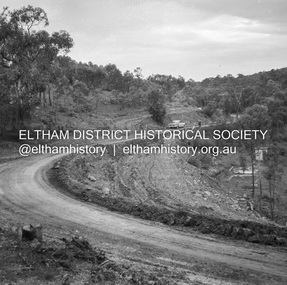
Negative - Photograph, J.A. McDonald, Heidelberg-Kinglake Road, Sep. 1960
Contractor Hillgrove Curve improvement south of St Andrews opposite CA 41 Sec. C, Parish of Greensborough October 1960 (probably September)Record of various Shire of Eltham infrastructure works undertaken during the period of 1952-1962 involving bridge and road reconstruction projects, sometimes with Eltham Shire Council Project Reference numbers quoted. It was during this period that a number of significant improvements were made to roads and new bridges constructed within the shire that remain in place as of present day (2022). In many situations, the photos provide a tangible visible record of infrastructure that existed throughout the early days of the Shire. The album was put together by or under the direction of the Shire Engineer, J.A. McDonald.infrastructure, shire of eltham, bridge construction, road construction, heidelberg-kinglake road, st andrews, 1960-09 -
 Phillip Island and District Historical Society Inc.
Photographs, Country Roads Board, Construction of 2nd Phillip Island Bridge 1966 - 1969, 1966 - 1969
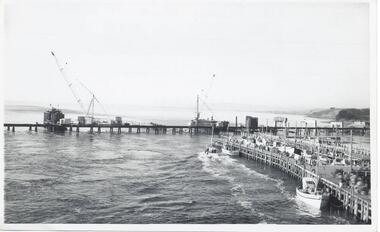
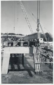
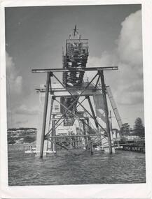
Collection of Black & White photographs of the construction of the second Phillip Island Bridge by the Country Roads Board. Contractor John Holland & Co Pty. Ltd.Black & White photographs of the Construction of the Phillip Island 2nd Bridge in 1969 351-01: View from centre of suspension bridge. 351-02: Concreting Pier 8 351-03: Concreting Pier 8 351-04,05 & 06: Metal beams. 351-07: Driving sheet Piling. 351-08:Reinforcement in caisson (watertight structure)351-01: Country Roads Board Victoria, Aust. Negative No. 67-37 - Phillip Island Bridge Project. Shire of Bass 352-02: As above - Negative No. 67-38B 352-03: As above - Negative No. 57-38D. 352-04: Negative No. 67-223A. 352-05: Negative No. 67-223B 352-06: Negative No. 67-223D 352-07: As 352-01-03 plus Negative No. 67-312 352-08: As above - Negative No. 67-272.phillip island bridge (1969), country roads board, sasha stark -
 Ringwood and District Historical Society
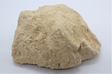
Geological specimen - Core sample, Section of core sample taken from Eastland Stage 5 - November 2014, Nov-14
Section of core sample taken from Eastland Stage 5 Nov 2014 - Donated by Terry Ahern, obtained through Probuild building contractorsSection of core sample taken from Eastland Stage 5 November 2014 +Additional Keywords: Eastland / Ahern, Terry / Probuild -
 Clunes Museum
Plan - PLAN OF PROPOSED ADDITIONS TO THE CLUNES BUTTER FACTORY
HAND DRAWN PLANS IN BLACK AND RED INK ON GLASS PAPER WHICH IS PINNED WITH DRESSMAKER'S PINS TO BROWN PAPER BACKING SCALE: 1 INCH TO 1 FOOT VARIOUS NOTATIONS HANDWRITTEN INCLUDES "CREATED BY HARRY E SANDO C.E. SIGNED BY ABEL GOLDSWORTHY, CONTRACTOR AND HARRY E SANDO IN BLACK INK 1 DEC 1894clunes butter factory, commercial industry in clunes -
 Ringwood and District Historical Society
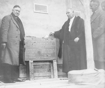
Photograph, Laying Foundation Stone for Auditorium section of Ringwood Town Hall. 1936
Black and white photographWritten on back of photograph: "Foundation Stone laying by Mayor McCaskill of Auditorian section of Town Hall. 27/6/1936. L to R- J. Taylor (Contractor), J.K. McCaskill (Mayor), I.C. Anderson (Architect)." -
 Eltham District Historical Society Inc
Negative - Photograph, J.A. McDonald, Heidelberg-Kinglake Road, Sep 1959
Job 56M430 Contractor Hone Just south of east abutment and access road to house showing block in table drain and wash towards Diamond CreekRecord of various Shire of Eltham infrastructure works undertaken during the period of 1952-1962 involving bridge and road reconstruction projects, sometimes with Eltham Shire Council Project Reference numbers quoted. It was during this period that a number of significant improvements were made to roads and new bridges constructed within the shire that remain in place as of present day (2022). In many situations, the photos provide a tangible visible record of infrastructure that existed throughout the early days of the Shire. The album was put together by or under the direction of the Shire Engineer, J.A. McDonald.infrastructure, shire of eltham, bridge construction, 1959-09, heidelberg-kinglake road, road construction -
 Eltham District Historical Society Inc
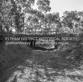
Negative - Photograph, J.A. McDonald, Heidelberg-Kinglake Road, Oct. 1959
Job 56M431 Contractors Wolf and Wood Yow Yow Creek Bridge Showing condition October 1959 Bypass back upstream side under constructionRecord of various Shire of Eltham infrastructure works undertaken during the period of 1952-1962 involving bridge and road reconstruction projects, sometimes with Eltham Shire Council Project Reference numbers quoted. It was during this period that a number of significant improvements were made to roads and new bridges constructed within the shire that remain in place as of present day (2022). In many situations, the photos provide a tangible visible record of infrastructure that existed throughout the early days of the Shire. The album was put together by or under the direction of the Shire Engineer, J.A. McDonald.infrastructure, shire of eltham, bridge construction, heidelberg-kinglake road, 1959-10, road construction, scan - 120 format 6x6 negative, yow yow creek -
 Eltham District Historical Society Inc
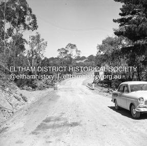
Negative - Photograph, J.A. McDonald, Henley Road at Watsons Creek, Mar. 1961
Henley Road at Watsons Creek Looking easterly along new alignment, 22 March 1961 C. Browns Excavator Contractor Wolf Cr PellingRecord of various Shire of Eltham infrastructure works undertaken during the period of 1952-1962 involving bridge and road reconstruction projects, sometimes with Eltham Shire Council Project Reference numbers quoted. It was during this period that a number of significant improvements were made to roads and new bridges constructed within the shire that remain in place as of present day (2022). In many situations, the photos provide a tangible visible record of infrastructure that existed throughout the early days of the Shire. The album was put together by or under the direction of the Shire Engineer, J.A. McDonald.infrastructure, shire of eltham, 1961-03, bend of islands, cr. charis pelling, henley road, henley road bridge, kangaroo ground, oxley bridge, watsons creek, w.e. wolf, bridge construction, road construction -
 Eltham District Historical Society Inc
Negative - Photograph, J.A. McDonald, Heidelberg-Kinglake Road, Mar. 1960
Cherry Tree Road Job 56F443 Contractors Wolf and Wood Cutting pipes on 45-degree skew using cordlex Showing secondary cracking March 1960Record of various Shire of Eltham infrastructure works undertaken during the period of 1952-1962 involving bridge and road reconstruction projects, sometimes with Eltham Shire Council Project Reference numbers quoted. It was during this period that a number of significant improvements were made to roads and new bridges constructed within the shire that remain in place as of present day (2022). In many situations, the photos provide a tangible visible record of infrastructure that existed throughout the early days of the Shire. The album was put together by or under the direction of the Shire Engineer, J.A. McDonald.infrastructure, 1960-03, bridge construction, cherry tree road, heidelberg-kinglake road, road construction, shire of eltham -
 Lakes Entrance Historical Society
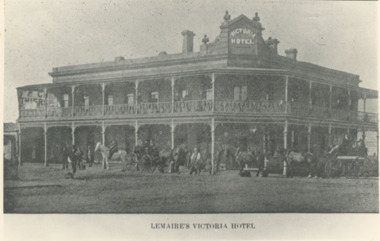
Photograph - Lemaires Victoria Hotel Bairnsdale Victoria, 1900 c
Designed by AF Kramer contractor Jonadab Townsend. Built on site of former Mitchell Hotel destroyed by fire 1885 First licensee of Victoria Hotel J A PatersonBlack and white photograph of Lemaires Victoria Hotel with small crowd of people horses and horse drawn vehicles out the front Main Street Bairnsdale Victoriabuildings, hotels -
 Lakes Entrance Historical Society
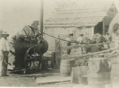
Photograph - Hay Baling, Steam engine baler, East Gippsland, 1915 c
Shed behind workers in clad and roofed with bark sheets held in place with horizontal timbers. The contractor with steam engine travelled around the district as requested by land ownersBlack and white photograph of five workers baling hay using small steam engine to power the baler on a farm in East Gippslandagriculture, steam engine -
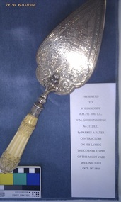 Freemasons Victoria - Gordon Lodge, 99
Gordon Lodge trowel - 1886 - used to lay the foundation stone
Engraved sterling silver trowel with ivory handle Presented to F W Lamonby PM 752, 1002 E.C. W.M. Gordon Lodge No. 2112 E.C. By Parker & Pater, Contractors On his laying the corner stone of The Ascot Vale Masonic Hall, Oct 14th 1886 -
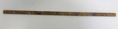 Warrnambool and District Historical Society Inc.
Functional object - Yard ruler, J Russell Pty Ltd, Mid 20th century
R J Russell operated a timber and hardware store in Koroit Street Warrnambool around the 1950’s. He succeeded from Newcombe Pty Ltd which had operated a timber and hardware store on the site (the present Target store) from the 1870’s. The business continued to trade under the Newcombe name after the death of Newcombe around 1900.A common well used item with links to a local business.Wooden yard ruler with markings in one eigthth inch measurements and numbered in inches. Text written in black on both sides.On front side: J Russell Pty Ltd. Timber and hardware merchants 148 Koroit Street Warrnambool. Phone 22. On reverse: Fencing materials, general hardware, paints, oils , Glass. Contractors or builders. Phone 22r j russell warrnambool, newcombe pty ltd warrnambool, timber yards warrnambool -
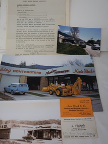 Kiewa Valley Historical Society
Papers & Photos & Business cards - Kevin Winch and J. Fleiberk
Kevin was certified as a plumber on 11th Dec. 1962 Kevin Winch was a plumber and builder contractor in Tawonga South. J. Fleiberk was a registered motor mechanic and gunsmith in Tawonga SouthKevin Winch lived at 20 Beauty Ave. Mt Beauty and was qualified to do all classes of plumbing Both businesses were in Tawonga South. Papers re Kevin Winch Plumber's licence from Waterworks Trust an Sewerage Authority Varying sized photos of Kevin Winch's Plumbing and Building Business in Tawonga south and his business card. J. Fleiber's business card in Tawonga South Signatures on the Plumber's Licence and on the back of 2 "Fees paid Renewed to 31-12-67 N. W. Alexander.kevin winch, j. fleiberk, plumber in tawonga south, gunsmith in tawonga south -
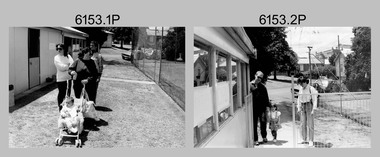 Bendigo Military Museum
Photograph - Christmas Children’s Party - Army Survey Regiment, Fortuna, Bendigo, 1992
This set of 16 photos of the Christmas Children’s Party were taken in the and the grounds of Fortuna, Army Survey Regiment in 1992. The Christmas party was an annual event enjoyed by the soldiers’ families, featuring amusements such as the ‘pig train’ and pony rides, a historic fire engine provided by the Golden Square Fire Brigade with Santa on board and refreshments such as cordial, lollies, ice creams and fairy floss. Single members readily volunteered to assist in the running of the party. An occasional highlight was displays of military hardware such as tanks and APC from the Puckapunyal’s Armoured Centre. Catering staff/contractors taking a break outside the kitchen are also featured in this collection. The Army Survey Regiment Wives Club was instrumental in establishing the Tennis Hut, featuring in photos .1P to .5P. The Wives Club initiated many social events. Examples of activities initiated by the club and their importance to the social fabric of the unit are described in more detail on page 151 of Valerie Lovejoy’s book 'Mapmakers of Fortuna – A history of the Army Survey Regiment’ ISBN: 0-646-42120-4.This set of 16 photos were taken in the grounds and kitchen area of Fortuna, Army Survey Regiment, Bendigo, at Christmas time in 1992. The photographs are on 35mm negative film and were scanned at 96 dpi. They are part of the Army Survey Regiment’s Collection. .1) - Photo, black & white, 1992, unidentified civilians and person. .2) - Photo, black & white, 1992, SGT Brian Fauth, SPR Carmel (Butler) Fauth and their child. .3) - Photo, black & white, 1992, L to R: SPR Joyce Gray, unidentified, SPR Andrew Arman. .4) to .5) - Photo, black & white, 1992, unidentified. .6) - Photo, black & white, 1992, Craig Kellett. .7) - Photo, black & white, 1992, L to R: Cam Bramich, unidentified (x2). .8) to.10) - Photo, black & white, 1992, unidentified. .11) to .15) - Photo, black & white, 1992, unidentified catering staff and contractors. .16) - Photo, black & white, 1992, Children’s rides on parade ground.No personnel are identified.royal australian survey corps, rasvy, army survey regiment, army svy regt, fortuna, asr -
 Bendigo Historical Society Inc.
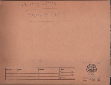
Document - MCCOLL, RANKIN AND STANISTREET COLLECTION: NAPOLEON REEF GOLD MINING CO. N.L, April - August 1940
Documents: Napoleon Reefs Machinery File, Loop Cobra Binder Folder containing: Quotes for contracts and machinery Supply (both typed & handwritten) From various Contractors/Suppliers (See attached PDF File for list), plus Boiler Certificate, Hire Purchase agreement, Auction Catalogue, Markings read 'Napoleon Reefs Machinery File' written in pencil on cover of file.organization, business, industrial - mining, mccoll rankin & stanistreet, mining, gold mining, napoleon reef -
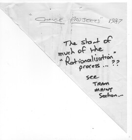 Melbourne Tram Museum
Document - Report, Metropolitan Transit Authority (MTA), "MTA Engineering & Maintenance Change Projects", 1987
Photocopied 140 page document titled "MTA Engineering & Maintenance Change Projects", produced by the MTA, 11/12/1987 setting out the proposal changes to MTA staff, use of contractors, consultation with the unions, consultation with unions, has a table of contents, index. Looks at construction activities, building maintenance and track maintenance, electrical and vehicle maintenance for the rail and tram divisions.trams, tramways, ptc, unions, tramways, railways, mta, workshops -
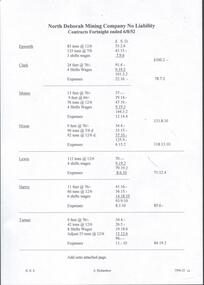 Bendigo Historical Society Inc.
Document - NORTH DEBORAH GOLD MINING CO N. L. - CONTRACTS FORTNIGHT ENDED 6/8/52
Two handwritten pages and typed copies of same, listing Contracts for the fortnight ended 6/8/52. Mentioned are the tons of ore, number of shifts, number of feet and expenses. Contractors are: Epworth, Clark, Monro, Nixon, Lewis, Harris, Turner, Panozzo, Bau and Greenwood. Copied from North Deborah Wages Sheet 12/11/70. Albert Richardson Collection. document, gold, north deborah gold mining co n. l., north deborah gold mining co n. l., contracts fortnight ended 6/8/52 north deborah gold mining co n. l., epworth, clark, monro, nixon, lewis, harris, turner, panozzo, bau, greenwood -
 Eltham District Historical Society Inc
Negative - Photograph, J.A. McDonald, Heidelberg-Kinglake Road, Mar. 1960
Cherry Tree Road Job 56F443 Contractors Wolf and Wood Junction of Cherry Tree and Flat Rock Roads – old alignment Looking along new alignment March 1960Record of various Shire of Eltham infrastructure works undertaken during the period of 1952-1962 involving bridge and road reconstruction projects, sometimes with Eltham Shire Council Project Reference numbers quoted. It was during this period that a number of significant improvements were made to roads and new bridges constructed within the shire that remain in place as of present day (2022). In many situations, the photos provide a tangible visible record of infrastructure that existed throughout the early days of the Shire. The album was put together by or under the direction of the Shire Engineer, J.A. McDonald.infrastructure, 1960-03, bridge construction, cherry tree road, heidelberg-kinglake road, road construction, shire of eltham, flat rock road -
 Phillip Island and District Historical Society Inc.
Photographs, Country Roads Board, Phillip Island 2nd Bridge Construction, 1966 - 1969
Eight of a collection of 70 photographs taken at the time of the Phillip Island second bridge construction by Country Roads Board & Shire of Bass. Contractor John Holland & Co Pty LtdEight Black & White photographs of the construction of the 2nd Phillip Island Bridge from San Remo to Newhaven - built from 1966 to 1969. Photographs showing various aspects of the construction.351-43: CRB NEG No. 67-1930E. Placing 1st Beam on Span 3. 351-44: CRB NEG No. 67-1930F. 1st Beam on Span 3. 351-45: CRB NEG No. 68-2126H. 351-46: CRB NEG No. 68-2126B. 351-47A: CRB NEG No. 67-2708A. 351-47B: CRB NEG No. 67-2708C. 351-48: CRB NEG No. 67-2708D. 351-49: CRB NEG No. 66-2860Aphillip island 2nd bridge construction, phillip island bridge, country roads board, shire of bass, john holland & co pty ltd, sasha stark -
 Lakes Entrance Historical Society
Photograph - Hop Kilns, M Fish, 1970
These hop kilns have since been destroyed by fire. Jubler was Architect of building, John French and Co Contractors. Built for James Taylor in 1882 Madres Field Hop KilnsColour photograph of Hop Kilns on Silt Jetties Road east side of Mitchell River Bairnsdale Victoriaindustry -
 Kew Historical Society Inc
Plan, Melbourne & Metropolitan Board of Works : Borough of Kew : Detail Plan No.1302, 1910
The Melbourne and Metropolitan Board of Works (MMBW) plans were produced from the 1890s to the 1950s. They were crucial to the design and development of Melbourne's sewerage and drainage system. The plans, at a scale of 40 feet to 1 inch (1:480), provide a detailed historical record of Melbourne streetscapes and environmental features. Each plan covers one or two street blocks (roughly six streets), showing details of buildings, including garden layouts and ownership boundaries, and features such as laneways, drains, bridges, parks, municipal boundaries and other prominent landmarks as they existed at the time each plan was produced. (Source: State Library of Victoria)This plan forms part of a large group of MMBW plans and maps that was donated to the Society by the Mr Poulter, City Engineer of the City of Kew in 1989. Within this collection, thirty-five hand-coloured plans, backed with linen, are of statewide significance as they include annotations that provide details of construction materials used in buildings in the first decade of the 20th century as well as additional information about land ownership and usage. The copies in the Public Record Office Victoria and the State Library of Victoria are monochrome versions which do not denote building materials so that the maps in this collection are invaluable and unique tools for researchers and heritage consultants. A number of the plans are not held in the collection of the State Library of Victoria so they have the additional attribute of rarity.Original survey plan, issued by the MMBW to a contractor with responsibility for constructing sewers in the area identified on the plan within the Borough of Kew. The plan was at some stage hand-coloured, possibly by the contractor, but more likely by officers working in the Engineering Department of the Borough and later Town, then City of Kew. The hand-coloured sections of buildings on the plan were used to denote masonry or brick constructions (pink), weatherboard constructions (yellow), and public buildings (grey). The absence of buildings and or property in Kew facing the Yarra is the most notable feature of this plan. Walmer Street and its bridge stretched, then and now, from Studley Park Road to Victoria Street, Richmond. On the Richmond side of the Yarra, there was evidence in 1904 of industry (‘Wool shed’; Soap Works’) and entertainment (‘Skittle Alley’). In reality, another Plan (No.1303) shows Chinese Gardens bordering the Yarra on the Kew side and buildings in Young Street.melbourne and metropolitan board of works, detail plans, mmbw 1302, cartography -
 Kew Historical Society Inc
Plan, Melbourne & Metropolitan Board of Works : Borough of Kew : Detail Plan No.1571, 1904
The Melbourne and Metropolitan Board of Works (MMBW) plans were produced from the 1890s to the 1950s. They were crucial to the design and development of Melbourne's sewerage and drainage system. The plans, at a scale of 40 feet to 1 inch (1:480), provide a detailed historical record of Melbourne streetscapes and environmental features. Each plan covers one or two street blocks (roughly six streets), showing details of buildings, including garden layouts and ownership boundaries, and features such as laneways, drains, bridges, parks, municipal boundaries and other prominent landmarks as they existed at the time each plan was produced. (Source: State Library of Victoria)This plan forms part of a large group of MMBW plans and maps that was donated to the Society by the Mr Poulter, City Engineer of the City of Kew in 1989. Within this collection, thirty-five hand-coloured plans, backed with linen, are of statewide significance as they include annotations that provide details of construction materials used in buildings in the first decade of the 20th century as well as additional information about land ownership and usage. The copies in the Public Record Office Victoria and the State Library of Victoria are monochrome versions which do not denote building materials so that the maps in this collection are invaluable and unique tools for researchers and heritage consultants. A number of the plans are not held in the collection of the State Library of Victoria so they have the additional attribute of rarity.Original survey plan, issued by the MMBW to a contractor with responsibility for constructing sewers in the area identified on the plan within the Borough of Kew. The plan was at some stage hand-coloured, possibly by the contractor, but more likely by officers working in the Engineering Department of the Borough and later Town, then City of Kew. The hand-coloured sections of buildings on the plan were used to denote masonry or brick constructions (pink), weatherboard constructions (yellow), and public buildings (grey). This plan is the other half of Plan No.1571 representing the constructions to the west of Wellington Street before and in 1903/4. This plan represents the built environment in Edgevale Road, Wellington Street, Atkins Street, Annadale Street, Mortimer Street, and Cotham Road. Whereas there are smaller allotments and more modest housing stock facing Edgevale Road, larger blocks and more substantial houses are represented facing Cotham Road.melbourne and metropolitan board of works, detail plans, mmbw 1571, cartography -
 Kew Historical Society Inc
Plan, Melbourne & Metropolitan Board of Works : Borough of Kew : Detail Plan No.1575, 1905
The Melbourne and Metropolitan Board of Works (MMBW) plans were produced from the 1890s to the 1950s. They were crucial to the design and development of Melbourne's sewerage and drainage system. The plans, at a scale of 40 feet to 1 inch (1:480), provide a detailed historical record of Melbourne streetscapes and environmental features. Each plan covers one or two street blocks (roughly six streets), showing details of buildings, including garden layouts and ownership boundaries, and features such as laneways, drains, bridges, parks, municipal boundaries and other prominent landmarks as they existed at the time each plan was produced. (Source: State Library of Victoria)This plan forms part of a large group of MMBW plans and maps that was donated to the Society by the Mr Poulter, City Engineer of the City of Kew in 1989. Within this collection, thirty-five hand-coloured plans, backed with linen, are of statewide significance as they include annotations that provide details of construction materials used in buildings in the first decade of the 20th century as well as additional information about land ownership and usage. The copies in the Public Record Office Victoria and the State Library of Victoria are monochrome versions which do not denote building materials so that the maps in this collection are invaluable and unique tools for researchers and heritage consultants. A number of the plans are not held in the collection of the State Library of Victoria so they have the additional attribute of rarity.Original survey plan, issued by the MMBW to a contractor with responsibility for constructing sewers in the area identified on the plan within the Borough of Kew. The plan was at some stage hand-coloured, possibly by the contractor, but more likely by officers working in the Engineering Department of the Borough and later Town, then City of Kew. The hand-coloured sections of buildings on the plan were used to denote masonry or brick constructions (pink), weatherboard constructions (yellow), and public buildings (grey). Plan No.1575 shows that in the area bounded by Wellington Street, Edgevale Road, Glenferrie Road, and Cotham Road, there had already been significant subdivision of land and houses constructed. As one of the highest points in Kew, as expected, there were already some significant mansions built on large allotments of land. Many of these mansions are identified by name on the plan such as ‘Kelso’, ‘Abbotsford’, ‘Clarendon’ and ‘Ashlyn’ in Cotham Road. Other houses of equal size are unnamed on the plan.melbourne and metropolitan board of works, detail plans, maps - borough of kew, mmbw 1575, cartography -
Clunes Museum
Drawing, Harry E Sando
ARCHITECT DRAWING OF CLUNES PRESERVING BOILER HOUSE .1 DATED 12 MARCH 1897 .2 DRAWING "BUILDING OF THE BOILER", LONGITUDAL ELEVATION APRIL 1987 .3 DRAWING NO. 1 DATED 12 MARCH 1897 .4 DRAWING OF MAIN BUILDING TESTING ROOM .5 DRAWING OF CAST IRON RING AND WROUGHT IRON COVER TO BOILER 21/4/1897.5 THESE ARE THE DRAWINGS REFERRED TO IN TENDER DATED 9 DAY OF APRIL 1897 FOR BUILDING BOILER AND OTHER WORK AT THE LOTHAIR BOILER HOUSE, DATED AT CLUNES THIS 29 DAY OF APRIL 1897 SIGNED BY THE CONTRACTOR, WITNESS TO SIGNATURE HARRY SANDO clunes preserving company, boiler house, lothair boiler house -
 Phillip Island and District Historical Society Inc.
Photographs, Country Roads Board, Phillip Island 2nd Bridge Construction, 1966 - 1969
5 of a collection of 70 photographs taken during the construction and opening of the Phillip Island second bridge - by Country Roads Board and Shire of Bass. Contractor was John Holland & Co Pty Ltd.Five Black & White photographs taken in 1966-1969 of the construction of the Phillip Island second bridge between San Remo and Newhaven. 351-65, 351-66 & 351-69 show the bridge construction. 351-67 & 351-68 show the cutting of the ribbon at the opening and the crowd of people at the opening.351-65: CRG NEG No. 67-3821.phillip island 2nd bridge construction, phillip island bridge opening 1969, country roads board, john holland & co pty ltd, shire of bass, sasha stark -
 Lakes Entrance Historical Society
Photograph - Skippers Restaurant, 1999c
This building was the original home of the family of George Carpenter, son of John Carpenter, first contractor for construction of the man-made entrance to the lake system, the house was relocated to Hunters Lane, December 2002.Colour photograph of Skippers Restaurant, Esplanade. The photograph shows a weatherboard building, corrugated iron roof, gabled extension at left end, hipped extension at right. Historical evidence shows that the building consists of additions to original smaller residence. Lakes Entrance Victoriaarchitecture, township, restaurant