Showing 5046 items matching "crown"
-
 Wodonga & District Historical Society Inc
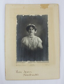
Photograph - Hamilton-Smith Collection Photograph of Gertrude Foord c. early 1900s, The Crown Studios: Vice-Regal Photographers
The Hamilton-Smith collection was donated by the children of Grace Mary Hamilton-Smith nee Ellwood (1911-2004) and John Hamilton-Smith (1909-1984) who settled in Wodonga in the 1940s. The Ellwood family had lived in north-east Victoria since the late 1800s. Grace’s mother, Rosina Ellwood nee Smale, was the first teacher at Baranduda in 1888, and a foundation member of the C.W.A. Rosina and her husband Mark retired to Wodonga in 1934. Grace and John married at St. David’s Church, Albury in 1941. John was a grazier, and actively involved in Agricultural Societies. The collection contains significant items which reflect the local history of Wodonga, including handmade needlework, books, photographs, a wedding dress, maps, and material relating to the world wars. This photograph is of Gertrude Foord (1885-1968), an aunt on the Hamilton-Smith family tree. Much of the needlework and textiles in the Hamilton-Smith collection belonged to Gertrude. This item has well documented provenance and a known owner. It forms part of a significant and representative historical collection which reflects the local history of Wodonga. It contributes to our understanding of social and family life in early twentieth century Wodonga, as well as providing interpretative capacity for themes including local history and social history.Black and white studio portrait photograph of a woman dressed in early 1900s dress, mounted on card.Handwritten inscription in bottom centre: "Love from/Gertrude". photograph, family photographs, photo, 1900s, edwardian, studio portrait, portrait -
 Federation University Historical Collection
Map - Geological Survey, J. Phillips, Geological Survey of Victoria - Ballarat, 1857, 10/1858
Geological map of the Ballarat District featuring four colours.ballarat, geological, geology, geological plan, main road, camp, golden point, pennyweight hill, clayton hill, ballaarat cemetery, bakery hill, specimen hill, soldiers hill, nightingale lead, native youth black hill flat, white flat, mining, mines, eureka lead, old post office hill -
 Eltham District Historical Society Inc
Document - Map, Victoria. Department of Crown Lands and Survey, Town of Eltham, Parish of Nillumbik, County of Evelyn, 2 October 1929
Township of Eltham, Parish of Nillumbik, County of Evelyn / lithographed at the Department of Lands & Survey Melbourne 5th June 1888, amended 2 October 1929 This amendment from the 1888 original shows the reserve for the the State School marked as permanent with dimensions added to Main Road and block frontages along Main Road between Mount Pleasant Road and Dalton Street and Metery Road Possibly photocopied from a copy held at PROV by Harry Gilham whilst resaerching Eltham Primary School history in 1995.a. armstrong, a. lavard, arthur c. allan, arthur c. allen, b. bowatere, baxter street, benjamin oliver wallis, bolton steet, c. souter, c.s. hain, cemetery reserve, charles brown, charles newman, charles symons wingrove, christopher caldwell, church of england, d. anderson, dalton street, david ballard, e. james, e.m. peck, edward dumaresq, eltham town, ely street, f.e. falkiner, f.m. peck, falkiner street, flint street, g. buckingham, g. drabble, george stebbing, godalmin street, h. peck, h.c.whess, h.h. farquharson, h.j. bews, henry stooke, j. goer, j. mcdonald, j. mclaren, j. roberts, j.b. knagers, james irish, jane bailey (nee matthews), john l. smith, john mason, john scott, john smith, joseph stevenson, joseph verse, k. wingrove, k.e. dunstan, kerby street, kirby street, location tbd, m. coman, map, michael o'shea, o.b. mccutcheon, p. & g. tumbull, p.k. mccaughan, p.p. cotter, porter street, pound reserve, robert hepburn, roman catholic church, s. evans, samuel dagley, samuel phillips, samuel ramsden, t. upton, t. watkins, t.a. stark, t.c.b. batt, t.p. cross, thomas grant, thornton street, w. adam, w. blain, w. long, w. watkins, w.f. ford, w.h. hull, w.r. belcher, w.t. schultz, william thomas, eltham primary school, eltham state school, eltham state school no. 209, quarry reserve -
 Lakes Entrance Historical Society
Book, Margaret Herd editor, Crown Content publisher, Who's Who in Australia, 2002
Since 1906 Whos Who in Australia has been regarded as the authoritative reference to notable people in AustraliaISSN 0810 8226 ABN 37096393636people -
 Warrnambool and District Historical Society Inc.
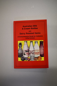
Book, Australian Milk and Cream Bottles, 2008
This book contains information on milk and cream bottles and other dairy-related items. It includes photographs of local milk and butter factories – Warrnambool (Allansford), Grassmere, Koroit, Garvoc, Glenormiston and Byaduk and references to Warrnambool milk suppliers – Antarctic Ice, Tooram and H Lindsay. No details have been found on H. Lindsay, selling milk in the 1920 to 1940 period. Antarctic Ice had a pasteurising plant in Kepler Street in the 1930s and sold to Warrnambool Cheese and Butter and Kraft in partnership and milk was sold under the new label, Sungold Dairies. They then purchased the Kaye Ryan pasteurizing plant in Verdon Street. Kraft moved out of the partnership with Warrnambool Cheese and Butter and Sungold Dairies relocated to the Allansford factory site where they still operate today. Tooram was the name of the property established in the Allansford area by the pioneer settler, John Allan. By the 1860s Tooram had become well-known for its cheese making and in the 1880s Tooram, owned by Thomas Palmer, had what was described as the finest dairy farm in Victoria. This book is of interest as it contains information on milk and cream bottles and dairy-related items and Warrnambool is the centre of an important dairying industry with the Warrnambool Cheese and Butter Factory in Allansford being the oldest existing dairy product factory in Australia. The book will be very helpful to researchers. This is a soft cover book of 224 pages. The cover has a red background with black printing and a colour image of five bottles and five other dairy-related items on the front cover and colour images of four bottles, a tin and three labels or signs on the back cover. The contents include text on milk and cream bottles and allied material and colour and black and white photographs. dairying in western district of victoria, warrnambool district dairying, history of warrnambool, sungold dairies, tooram -
 Lakes Entrance Historical Society
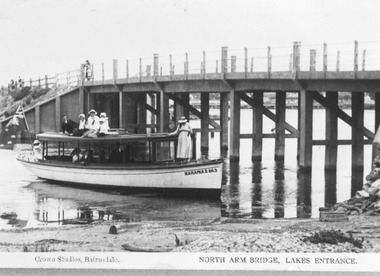
Photograph - Maranui 2, Crown Studios Bulmer, 1917c
Concrete bridge over North Arm, constructed by Coate Bros. opened September 1917. Also Maranui Guest House history.Black and white photograph of a tourist launch named Maranui 2 beside the North Arm Bridge. People on launch dressed in summer clothing of pre WW1 era. Posts and steel rope rails on bridge. Low tide indicated by height of bridge piers out of the water. Lakes Entrance Victoria boats and boating, bridges, clothing -
Moorabbin Air Museum
Booklet - How to Draw AIRPLANES, JIM DUNAVENT, 1973
-
 Clunes Museum
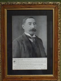
Photograph, Crown Photographers
Lord Northcote was Australia's 3rd Governor General.Framed black and white photograph of the Governor General of Australia Lord Northcote. Carved frame around edge, gilt edge on inside of frame. Typed message on rectangular paper by Lord Northcote.lord northcote, governor general, politics -
 Whitehorse Historical Society Inc.
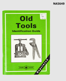
Booklet - Old tools, Crown Castleton Publisher, Golden Square Vic, Australia
Old tools Identification Guide Compiled by Ken ArnoldGreen booklet - old tools Identification guide - 64 PagesTed Arrowsmithwoodwork -
Moorabbin Air Museum
Book - JG26 Top Guns of the Luftwaffe, Donald J. Caldwell, 1991
-
 Lakes Entrance Historical Society
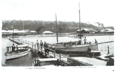
Photograph - Broome's Federal Guest House Lakes Entrance Victoria c1915, Crown Studios Bairnsdale, c1919
Broome's Federal Guest House jetty from Esplanade to deeper water of Cunninghame Arm, where fishing boat Eva and launch Maureen are moored. c1919Black and white photograph of a postcard showing Broome's Federal Guest House and three other buildings on Esplanade, Lakes Entrance Victoria c1919accommodation, jetties, waterfront, guesthouses, boats and boating -
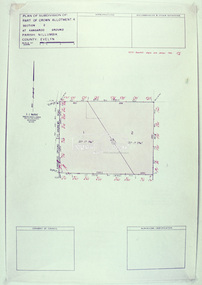
 Ringwood and District Historical Society
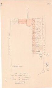
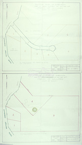
Map - Plan of Survey, Part of Crown Portion 12, Parish of Ringwood, Victoria - circa 1930
Map of area bounded by Ringwood Street, Melbourne Street and Adelaide Street, showing details of Adelaide Street allotments and existing outbuildings. Certificate of Title numbers include Ringwood Street C/T 3418-553, C/T 3563-433, Adelaide Street C/T 7151-047, C/T 7038-465, C/T 7098-464, C/T 7098-465, C/T 3604-635, C/T 8066-900, C/T 3866-118, C/T 3609-728, and C/T Vol 3670 Fol 133992.Subsequent additional notations identifying 1971 closure of Melbourne Street North, and properties of Hone, Patendon, Pines Hosptial, Mail Office, Presbyterian Church and Falconers Grocery Shop on Whitehorse Road corner. -
 Ringwood and District Historical Society
Map - Public Land Sale by Thomas Ham, 2000 Acres for Sale - Crown Sections 20, 23, 24 - Ringwood, Victoria - 1855
Two 1850s surveyor's maps on cardboard backing showing area from Melbourne extending East beyond Bulleen and Nunawading. Detailed description of lots for sale and navigational directions to the property from Richmond by Thomas Ham, Victorian public servant, map maker, publisher, lithographer and original Ringwood land owner. Inset map enlarging area between Yarra River and Dandenong Creek, with southern boundary of allotments later forming part of Oban Road, North Ringwood.TRANSCRIPT: "This really valuable Property is now offered to the public for sale, in lots to suit purchasers at the Iow rate of £1 per Acre for 80 acres and upwards, and £1.10s per Acre for any smaller portion. Terms of payment Half Cash, Balance in 6 and 12 months, bearing 8 per cent interest. The Estate is well wooded with Gum, Cherry Tree and Stringy Bark, with Wattle in the valleys of the several creeks. Every lot is Staked and Trenched at the corners marked on the Plan thus - The Surveyor has carefully sub-divided the Property, in order to give every Farm a Creek for Water, Valley for Cultivation, and Hills for House and Grass Paddock. The ROADS have been very carefully laid out so as to give a firm, well drained, and nearly level road to each Homestead. Intending purchasers can readily find the property by the following directions, viz: Start from Richmond Bridge, at Hawthorne, then take the left-hand road to KEW. When at the "Woodman Inn", take the Cotham Road to the right, bearing due east, keep this Road, passing Trainor's "White Horse" Inn, and before you leave the fences, you will see calico bills (see margin) nailed to the Trees on the bush track leading to the Upper Yarra country, follow the Bills till you come to the SOUTH boundary line of the Property, which bears East and West (see Plan) where you will see Bills nailed up "THIS PROPERTY FOR SALE, etc." The Bills from Town lead direct to where Mr. Jull is erecting his Store, and arrangements have been made with him to show the lots to intending purchasers free of charge. At the respective corners of the lots the Bills are nailed up double, with numbers to denote the lot, and that the corner stake is adjacent. Any parties wishing to proceed to the property by way of BULLEEN will find Bills nailed on the Trees, commencing at the NEW INN, at "Wilson's Slip Rail." Keep this Track till you come to the Log Bridge, over the Deep Creek at Bloxhome's Paddock; go through the land now being cleared; keep the track over the hill till you come to an Iron House, you will then be on the property, which Iies to the North and East as per Plan. Follow the Bills till you come to Mr. Jull's Store, etc. etc. Further particulars can be had from the Agent for the Property. THOMAS HAM. " -
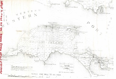
 Phillip Island and District Historical Society Inc.
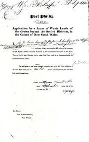
Document, Grant to W.J.McHaffie for lease of Crown land
J D McHaffie, Phillip Island's first leaseholder, relate how McHaffie set up his headquarters (and later built his house) alongside what is now known as McHaffies lagoon. The McHaffie brothers – John David and William – occupied Phillip Island under a license from the Admiralty in 1842 and farmed it as a sheep run.Historical3 A4 photocopies showing application for lease in 1850, size and description of the land and instructions for the application.w.j.mchaffie, land grant, farming, saltwater creek, crown land -
 Phillip Island and District Historical Society Inc.
Document, 1869 Crown Land sale and map of Phillip Island showing allotments
Anderson and McHaffie were prominent early settlers of Phillip Island. These documents were from the estate of Stan Mcfee snr. Listings of auctions at Gemmell, Tuckett & Co., Collins Street, Melbourne 12 February, 1869HistoricalCopy of map showing allotments for 1869 land sale and hand written note showing allotments, area, prices for purchases of Robert Anderson and notes on McHaffie land.robert anderson, glen isla, john mchaffie, maps, land sales -
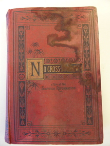 Warrnambool and District Historical Society Inc.
Book, No cross no crown
This book has been given by the Woodford Sunday School to Edith Cassady (note the misspelling of ‘Cassady’). Edith Cassady was the daughter of William and Elizabeth who lived at Boughton on the Merri River (near Cassady’s Bridge, Caramut Road today). This property was established about 1845. The donor of the book was William Wines, a member of a pioneering family in the Woodford district. This book is of some interest as it belonged to Edith Cassady, a member of a pioneering family who lived at Boughton on the Merri River. This is a hard cover book of 344 pages. The cover is red with black border decorations and black and gold lettering. There are several full page black and white illustrations scattered throughout the book which has 23 chapters of story. The cover and pages are much water-stained. The inscription is handwritten in black ink. ‘Woodford Sunday School Presented to Edith Cassidy (sic) by her well-wisher William Wines’ william wines, woodford, history of woodford, edith cassady, boughton property, cassady family -
 Eltham District Historical Society Inc
Slide - Photograph, Eltham Shire Council, Plan of Subdivision, Crown Allotment 8, Section 8A, Parish of Nillumbik,County of Evelyn, 1969
35mm colour positive transparency blue Agfacolour Service plastic mountC1, Pain, Sibbel and Carter, Research-Warrandyte Road, North Warrandyte, 4 August 1969carter, infrastructure, map, north warrandyte, pain, parish of nillumbik, plan of subdivision, planning, research-warrandyte road, sibbel, subdivison lots -
 Eltham District Historical Society Inc
Slide - Photograph, Eltham Shire Council, Plan of Subdivision of Part of Crown Allotment 4, Section 2 at Kangaroo Ground, Parish of Nillumbik, County of Evelyn, 1969
35mm colour positive transparency blue Agfacolour Service plastic mountC6, Kimse, Kangaroo Ground-St Andrews Road, 4 August 1969infrastructure, kangaroo ground, kangaroo ground-st andrews rd, kimse, map, plan of subdivision, planning, subdivison lots -
 Eltham District Historical Society Inc
Slide - Photograph, Eltham Shire Council, Plan of Subdivision, Part of Crown Portion 3, Parish of Nillumbik, County of Bourke, 1969
35mm colour positive transparency blue Agfacolour Service plastic mountC5C, Delbridge, 4 lots, Rattray Road, 4 August 1969infrastructure, map, montmorency, planning, rattray road, subdivison lots, reichelt avenue -
 Eltham District Historical Society Inc
Slide - Photograph, Eltham Shire Council, Tentative plan of subdivision, part of Crown Allotment 22, Section B, Parish of Greensborough, County of Evelyn, 1969
35mm colour positive transparency blue Agfacolour Service plastic mountE11, N1069, Stogryn, Sub 'prop',infrastructure, map, planning, subdivison lots -
 Eltham District Historical Society Inc
Slide - Photograph, Eltham Shire Council, Proposed subdivision of Part of Crown Allotment 8B, Section 8A, Parish of Nillumbik, 1969
35mm colour positive transparency blue Agfacolour Service plastic mountE4, N0424, Stock subdivision, North Warrandyte, 4 August 1969infrastructure, map, planning, subdivison lots -
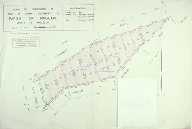 Eltham District Historical Society Inc
Slide - Photograph, Eltham Shire Council, Plan of subdivision of Part of Crown Allotment 41, Parish of Kinglake, County of Anglesey, 1969
35mm colour positive transparency blue Agfacolour Service plastic mountC8, N. Johnson, Kinglake-Glenburn Road, 4 August 1969infrastructure, map, planning, subdivison lots, n. johnson, kinglake-glenburn road, kinglake -
 Eltham District Historical Society Inc
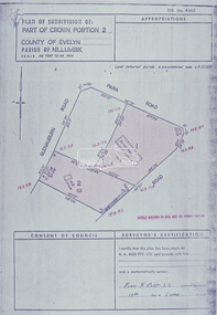
Slide - Photograph, Eltham Shire Council, Plan of subdivision of Part of Crown Portion 2, Parish of Nillumbik, County of Evelyn, 1969
35mm colour positive transparency blue Agfacolour Service plastic mountC4, Warton, Panorama and Beleura, 4 August 1969infrastructure, map, planning, subdivison lots, beleura grove, old eltham road -
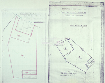
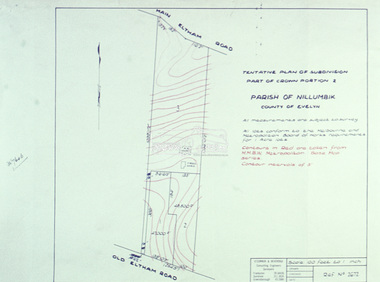 Eltham District Historical Society Inc
Slide - Photograph, Eltham Shire Council, Tentative Plan of Subdivision, Part of Crown Portion 2, Parish of Nillumbik, County of Evelyn, 1969
35mm colour positive transparency blue Agfacolour Service plastic mountB4, Fisher subdivision, Old Eltham Road and Main Road, 4 August 1969infrastructure, map, planning, subdivison lots, main road, old eltham road -
 Eltham District Historical Society Inc
Slide - Photograph, Eltham Shire Council, Tentative Plan of Subdivision, Part of Crown Allotment 20A and Part 20B, Parish of Nillumbik, County of Evelyn, 1969
35mm colour positive transparency blue Agfacolour Service plastic mountE2, N899, Young subdivision, Kangaroo Ground-Warrandyte Road, North Warrandyte, 4 August 1969infrastructure, map, planning, subdivison lots, kangaroo ground-warrandyte road, north warrandyte -
 Eltham District Historical Society Inc
Slide - Photograph, Eltham Shire Council, Plan of Subdivision, Part of Crown Allotments 5 & 6, Section 10, Parish of Nillumbik, County of Evelyn (Foster Road, Eltham East), 1969
35mm colour positive transparency blue Agfacolour Service plastic mountC5(a) DU (Vic) D/L Foster Road, Eltham East, 4 August 1969infrastructure, map, planning, subdivison lots, abersham court, ancona close, eltham east, floriston grove, foster road, frank street, gladwyn court -
 Eltham District Historical Society Inc
Slide - Photograph, Eltham Shire Council, Plan of Subdivision of Part of Crown Portion 2, Parish of Nillumbik, County of Evelyn, 1969
35mm colour positive transparency blue Agfacolour Service plastic mountC2, Grant of subdivision, Para and Glenauburn, 4 August 1969infrastructure, map, planning, subdivison lots, glenauburn road, para road -
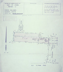
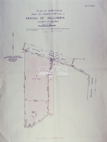 Eltham District Historical Society Inc
Slide - Photograph, Eltham Shire Council, Plan of Subdivision, Part of Crown Portion 3, Parish of Nillumbik, County of Bourke, 1969
35mm colour positive transparency blue Agfacolour Service plastic mountB3 Robinson prelim subdivision, View Road, 4 August 1969infrastructure, map, planning, subdivison lots, rattray road -
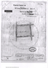
 Eltham District Historical Society Inc
Document - Photocopy, Survey Fleld Notes of Part of Crown Portion 13, Section 4 at Eltham, Parish of Nillumbik, County of Evelyn, 1902-1903
Main Road, Henry Street to Diamond Street; Silver Street to Bible Street Application No. 0337771902, 1903, arthur street, bible street, bird street, diamond creek (creek), diamond street, eltham, eltham railway station, henry street, main road, silver street, survey plan, vine street, application 33777, map -
 Eltham District Historical Society Inc
Document - Photocopy, Survey Fleld Notes of Part of Crown Portion 13, Section 4 at Eltham, Parish of Nillumbik, County of Evelyn, 18 May 1908
Portion of land bounded by: Main Road, Luck Street, Bible Street, Arthur Street Application 37314 W. P. Steane, M.C.E. Civil Engineer and Surveyor, 18 May 1908application 37314, arthur street, bible street, eltham, luck street, main road, map, survey plan