Showing 1371 items
matching east side
-
 Eltham District Historical Society Inc
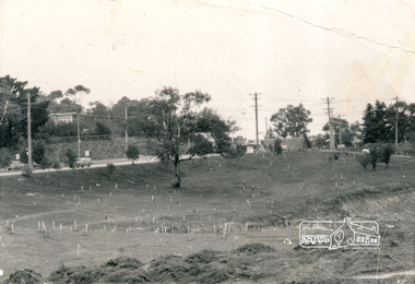
Photograph, Alistair Knox Park, Eltham, c.1970, 1970c
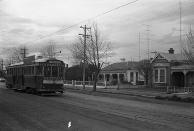
... intersection showing the rock wall on the east side of the original... intersection showing the rock wall on the east side of the original ...View from northwest corner showing survey pegs for trees and two ponds. Main Road has been duplicated. Bridge Street intersection showing the rock wall on the east side of the original Main Road (Maria Street). Burgoyne's Store and Eltham Uniting Church in distance at centre right and Our Lady Help of Christians at centre left.In February 1968 an unknown person took a series of photos from the Eltham Hotel at Pitt Street heading north along Main Road through the shopping centre to just north of Elsa Court covering the length of the section of Main Road which was duplicated shortly thereafter. Shows the condition and environment of the streesscape of Main Road, Eltham immediately prior to the duplication between Pitt Street and Elsa Court through the shopping centre. Also shows a number of shops and businesses that operated at that time.Black and white photographduplication, eltham, main road, bridge street, burgoyne's shop, eltham uniting church, our ladys church, maria street -
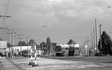
 Ballarat Tramway Museum
Photograph - Black & White Photograph/s, Ian Barkla, 17/01/1969 12:00:00 AM
... placing trolley poles and grass on the east side of terminus... and grass on the east side of terminus, showing narrow width ...Black and white photograph of Ballarat No. 36 at Lydiard St. terminus - 17-1-69. Tram has SEC roof ad at Sth end of tram, and destination of 'Sebastopol'. Note pan in overhead for assisting placing trolley poles and grass on the east side of terminus, showing narrow width of roadway at the time of the photograph. On Kodak paper.On rear in black biro "Ballarat, 17-1-69 / 36 Lydiard St. Nth, Ex 132 MMTB."trams, tramways, ballarat, lydiard st. nth , tram 36 -
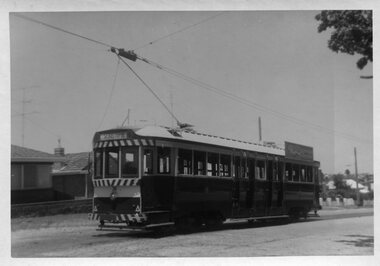
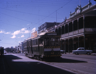
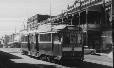 Ballarat Tramway Museum
Photograph - Digital image, c1971
... " In the background is the streetscape on the east side of Lydiard St Nth... kitchen" In the background is the streetscape on the east side ...Yields information about Ballarat streetscape and its trams in the closing days of the SEC tramway system.Digital image from a black and white print of tram 42 southbound in Lydiard St North, for Sebastopol. Tram has an "Everything is under control in my all electric kitchen" In the background is the streetscape on the east side of Lydiard St Nth, including the Colonists Hotel, Davidsons shop and the Art Gallery. Photo by Marc Dahlstrom c1971. On rear is the Marc Dahlstrom stamp.trams, tramways, lydiard st north, tram 42 -
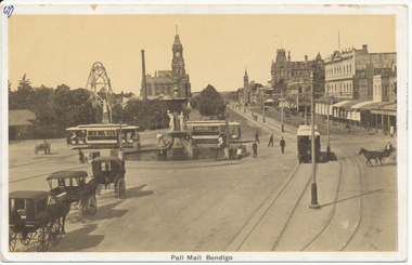 Ballarat Tramway Museum
Postcard, Rose Stereograph Co, Charing Cross, Bendigo, mid 1900's
... cabs and vehicles, a poppet head and building on the east side..., a poppet head and building on the east side of the Pall Mall ...Demonstrates aspects of the development of the Bendigo tramways by ESCo prior to undertaking the Ballarat system. Yields information about Charing Cross soon after the electric tramway was opened.Black and White postcard, early 1900's view of Charing Cross, Bendigo looking towards the north, Pall Mall. Has three tram cars in the view, the fountain, centre poles, horse drawn cabs and vehicles, a poppet head and building on the east side of the Pall Mall. Divided back postcard with areas for message, address, and the stamp. Has "67)" in the top left hand corner of the back of the card, a circled "13" crossed out, "early 1900's" in ink. In the top right hand corner "$8" in pencil. On the front of the card has "67)" in the top left hand corner in ink.trams, tramways, bendigo, pall mall, charing cross, tram 4 -
 Ballarat Tramway Museum
Photograph - Digital image, 1970s
... to the east side. Telephoto lens photos - shows both tracks..., the highway, from the west to the east side. Telephoto lens photos ...Yields information about the way the trams crossed Albert St Sebastopol.Digital image, black and white, of No. 41 crossing northbound in Albert St ex Sebastopol, the highway, from the west to the east side. Telephoto lens photos - shows both tracks and buildings. Photo taken by Peter Bruce 1970's and 1971, prior to the closure of the Ballarat tramway system. Peter's Title of image: "No. 41 crossing the highway"trams, tramways, albert st, sebastopol, tram 41 -
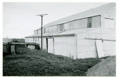 National Wool Museum
Photograph
... and demolished in 1989. View from east side of shed. A modern version... and demolished in 1989. View from east side of shed. A modern version ...Depicts Booyoolee Shed, which was built in 1856 and demolished in 1989. View from east side of shed. A modern version of a "stobie" pole can be seen, which was used to carry 240 volt power to shed to drive the overhead, enabling the old combustion engine to be dispensed with. Taken by John Bailey in South Australia at the request of Gael Shannon (former NWM employee). -
 Linton and District Historical Society Inc
Photograph, Taylors Super Snaps Ballarat, Sussex Street, Linton
... Sussex Street. Visible east side: Edinburgh Bakery, Preston's... Sussex Street. Visible east side: Edinburgh Bakery, Preston's ...Photograph taken from high vantage point further along Sussex Street. Visible east side: Edinburgh Bakery, Preston's shop, Wishart's blacksmiths. Church of England vicarage in the distance. Visible west side: roofs of Morgan's and Sandow's stores. The photograph is undated but thought to have been taken in the 1940s, as there are electricity poles in the street. (Electricity came to Linton in 1939).Very small photograph of Sussex Stret, Linton, view to south-east.sussex street linton -
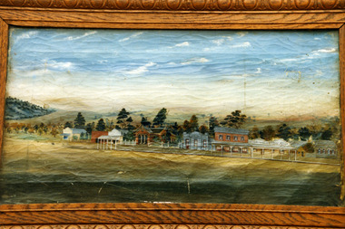 Charlton Golden Grains Museum Inc
Photograph, High St Charlton . 1892
... Copy of painting of east end and south side of High Street...Coloured photo of a framed painting of the east end, south...Copy of painting of east end and south side of High Street ...Copy of painting of east end and south side of High Street Charlton c. 1892. Businesses identifiable in the picture include the Post Office, The Bank of Australasia, Klunder's East Charlton Bakery and the Tribune Office.Coloured photo of a framed painting of the east end, south side of High St Charlton. Shows 10 buildings; general store, Post Office, Bank of Australasia (?), two storey brick building (four windows, three doors), Klunder's East Charlton Bakery , Tribune Officehigh street charlton, post office, bank of australasia, klunder's bakery, tribune -
 Coal Creek Community Park & Museum
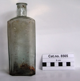
Bottle, glass, W. A. Stokes, Chemist
... 'W. A. STOKES CHEMIST EAST ST.KILDA' on side. 'K6232... CHEMIST EAST ST.KILDA' on side. 'K6232' on base. Rectangular clear ...TROVE : Jewish Herald (Vic. : 1879 - 1920) Friday 14 March 1913 p 10 Advertising. Mr. Frank Newman desires to intimate that he has purchased the old-established business of the late MR. W. A. STOKES, recently carried on by Mr. P. J. Winch, and hopes by giving; his personal attention to the Pharmacy to merit your support. 181 CARLISLE ST.. BALACLAVA. Tel. Windsor 30. TROVE : The Age (Melbourne, Vic. : 1854 - 1954) Tuesday 13 December 1887 p 5 Article " ROUGH ON RATS" POISON.' . PROSECUTION UNDER THE POISONS ACT. At the St. Kilda police court, on Friday, W, A. Stokes, chemist, Carlisle-street, Balaclava, was prosecuted under the Poisons Statute on the charge of selling to one Mrs. Hannah Charlton a poison without having made and signed the entry required by the act. A second charge of selling to Mrs, Hannah Charlton a poison without having obtained the signature of the purchaser to an entry as required by the act was also preferred against the defendant. Both cases were taken together. Mr, Donovan appeared to prosecute, and Mr. Cole for the defence. Senior-constable Connell deposed that he knew the defendant. On the 24th of October last an inquest was held at East St. Kilda relative to the cause of the death of a man named Charlton. A packet bearing the label " Rough on Rats," which was found. in the deceased's bedroom, was produced at the inqiry, and afterwards handed over to Mr. Blackett, Government analytical chemist for analysis. The verdict of the jury was that the deceased died from the effects of arsenical poisoning. Hannah Charlton, a widow, residing in South Yarra, said in September last she purchased a packet of "Rough on Rats" from the defendant's assistant. Witness was not asked her name, place of abode, occupation or for what purpose the poison was required; neither did she observe the assistant make any entry in a book, She did not attach her signature to any document, and was not asked to do so. The packet was purchased for the purpose of poisoning rats. Cuthbert Robert Blackett, Government analytical chemist, stated that Constable Ballantyne handed him the packet produced. Witness made an analysis of the contents, and found it composed of arsenic, slightly coloured with a carbonaceous matter. The mayor announced that there was a doubt in the minds of the magistrates as to whether the defendant could be held guilty under the law, but they thought the prosecution had attained its object by making known the fact that "Rough on Rats" is a poison. They thought that such preparations should be entered by the sellers, but in that case they were inclined to give the defendant the benefit of the doubt and dismiss the case.Rectangular clear light green tinted glass bottle with embossed text and numerals on side and base.'W. A. STOKES CHEMIST EAST ST.KILDA' on side. 'K6232' on base.chemist, poison, arsenic -
 Charlton Golden Grains Museum Inc
Photograph, High St Charlton c. 1988, c.1988
... building. Other buildings on the east side of HIgh St include... building. Other buildings on the east side of HIgh St include ...Bilton/Dillon building c. 1988 occupied by the Charlton Pharmacy managed by R. English, H. Hargreaves Gift Shop and the Mallee Kitchen. Series of photos taken of High Street after new footpaths and kerbing were put down in 1987-88.Colour photograph of High St Charlton looking east. Photo taken high on the south side looking across to Bilton/Dillon building. Other buildings on the east side of HIgh St include Westpac Bank, Globe Hotel, The Charlton Club, East Charlton Hotel. On the south side is the awning for the Charlton Cinema. Bunting is stretched across the street.bilton building, dillon building, english chemist, hargreaves gift shop, mallee kitchen -
 Greensborough Historical Society
Photograph (copy), Plenty River Tea Gardens, 1929c
... Plenty River Tea Gardens were located on east side of Main... located on east side of Main Street near St Helena Road ...Plenty River Tea Gardens were located on east side of Main Street near St Helena Road intersection. [Ref: The Age 18/2/1929 page 3 - Greensborough - Comfortable Home. 6 rooms. large verandas. ½ acre. S O bungalow. Lovely spot. 4 minutes station. Furnished or unfurnished or will sell reasonable. River Plenty Tea Gardens. Phone Gr. 17]Two black & white photographsplenty river tea gardens, greensborough tea rooms -
 Melbourne Tram Museum
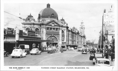
Postcard, Rose Stereograph Co, "Flinders St Railway station Melbourne", c1940
... the eastbound safety zone stop on the east side of Swanston Street. ... stop on the east side of Swanston Street. Yields information ...Rose Series postcard No. P 1060, titled "Flinders St Railway station Melbourne," shows a W2 with white war time paint on the bumper bar crossing Swanston Street (Route 28?) with many cars and one horse-drawn cart in the view. On the est bound safety zone stop are several men in military uniforms. Note the eastbound safety zone stop on the east side of Swanston Street. Yields information about the intersection of Flinders and Swanston Sts.Postcard - printed real photograph with Rose Stereograph Co. name on the rear.Has been used as a part letter to Ken Magor.trams, tramways, w2 class, flinders st station, flinders st, swanston st, safety zones, world war ii, princes bridge station -
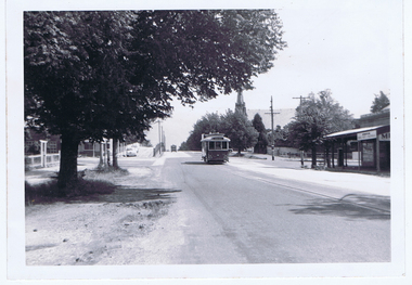
 Ballarat Tramway Museum
Photograph - Colour Photograph/s, David Endacott, 1971
... opposite the concrete retaining wall on the east side of Lydiard St... in Lydiard St. North opposite the concrete retaining wall on the east ...Colour print of a Ballarat No. 30 in Lydiard St. North opposite the concrete retaining wall on the east side of Lydiard St. North, just before Macarthur St, the cutting was between Clarendon St and Macarthur St. Tram has destination of Lydiard St. Nth. Has homes and the city of Ballarat in the background. Original film image scanned at 3200dpi 12/5/2020.On rear in blue ink "Lydiard St. Nth" and in the top left hand corner "1971".ballarat, lydiard st. nth, retaining wall, tram 30 -
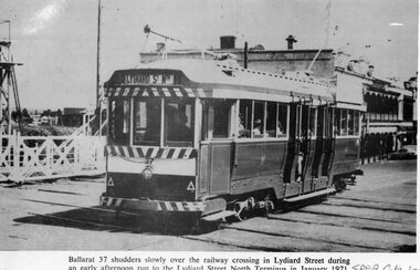 Ballarat Tramway Museum
Photograph - Illustration/s, Ballarat 37
... destination of "Lydiard St. Nth." Has buildings on the east side... destination of "Lydiard St. Nth." Has buildings on the east side ...Black and white illustration from the South Pacific Electric Railway Co-op (Sydney Tramway Museum) - Feb. 1974 calendar of Ballarat tram No. 37 crossing the railway crossing in Lydiard St. North, January 1971. Photo by D.Cooke. Tram showing destination of "Lydiard St. Nth." Has buildings on the east side of Lydiard St. in background and railway gates.On bottom right hand corner "SPER Calendar February 1974"trams, tramways, ballarat, lydiard st. nth, railway crossing -
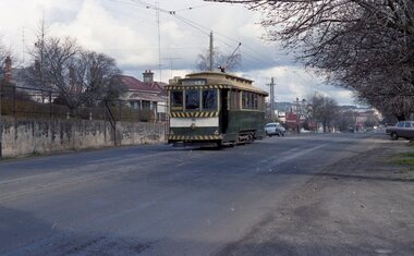
 Ballarat Tramway Museum
Slide - 35mm slide/s, Theo Dunstan, Aug. 1971
... destination of Sebastopol. Has buildings on the east side... destination of Sebastopol. Has buildings on the east side ...35mm slide, square format mounted in a "Kodak " cardboard slide mount with Kodak logos and printing of No. 42 about to use the Lydiard St. crossover. Tram has reversed direction and has destination of Sebastopol. Has buildings on the east side of the Lydiard St. Nth in the background include the Mining Exchange. Taken 23/8/1971 - the last Sunday of full operations? Has date of "Sep 71" and "19" stamped onto the slide.tramways, trams, sturt st, lydiard st nth, tram 42 -
 Warrnambool and District Historical Society Inc.
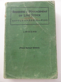
Book, Breeding & management of live stock, 1943
... was on the east side of Liebig Street between Lava and Koroit Streets... has the stamp of ‘Ecker’s Hotel’. This hotel was on the east ...This book has the stamp of ‘Ecker’s Hotel’. This hotel was on the east side of Liebig Street between Lava and Koroit Streets and was opened in 1875 by James Dooley. It was take over in 1885 by James Taylor and then by Joe Ecker in 1910. When Joe Ecker left the hotel in 1923 the licensees following retained the name ‘Ecker’s’. The hotel closed in 1962. It is the only hotel in Warrnambool to have had no other name except that of three of its owners. This book is only of interest because of its connection with Ecker’s Hotel, well-known in Warrnambool for 90 years as a comfortable, well-managed place to stay or visit. No doubt many of the clientele were farmers and this would explain the reason for the book being retained at the hotel. This is a hard cover book of 408 pages. It has a green cover with black lettering on the front cover and on the spine. It has a Preface, a Contents page, 25 chapters of Text, a Gestation Table and an Index. There are many black and white photographs and illustrations scattered throughout the text. The back page is torn and the cover is scuffed and the book is a little warped out of shape. There is some pencil scribble on the first page and a black-coloured stamp. ‘Ecker’s Hotel’ ecker’s hotel, warrnambool, joe ecker, warrnambool history -
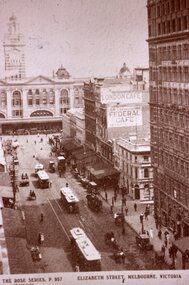 Melbourne Tram Museum
Slide - Black and white reproduction photograph - Elizabeth St Melbourne, 1920c
... /telephone line on the east side of the street. Original photo.../telephone line on the east side of the street. Original photo ...Photograph - looking south along Elizabeth Street Melbourne to towards Flinders Street station. Has three cable trams in the photo, including one shunting at the terminus. Has signs for the London Cafe and Federal Cafe in the view, along with many horse-drawn vehicles and a few motor cars. There is a telegraph/telephone line on the east side of the street. Original photo by Rose Stereograph Co. P 957 - see reference. Yields information about the south end of Elizabeth St and the cable tram terminus.Kodachrome cardboard duplicate slide - Black and white reproduction photograph - Elizabeth St c1920 "CB9" in penciltrams, tramways, cable trams, elizabeth street, flinders st station -
 4th/19th Prince of Wales's Light Horse Regiment Unit History Room
Brass tankard
... Faintly engraved map of Middle East on one side and mosque... of Middle East on one side and mosque on other Trench art, brass ...Trench art, brass tankard, brass bottom, Handle attached with solder Faintly engraved map of Middle East on one side and mosque on othertankard, mess property -
 Yarra Glen & District Historical Society
Sepia postcards, Yarra Glen
... . On east side of Bell Street are a dwelling, a general store... Street. On east side of Bell Street are a dwelling, a general ...Sepia postcard with a view taken from the Grand Hotel tower looking down on Bell Street and the railway crossing at Yarra Glen very late 19th century. Young street trees on Bell Street. On east side of Bell Street are a dwelling, a general store, the Victoria Hall, a horse trough. Beyond the railway line is 'River View', the bridge over the river and the Yering flats.On back of postcard at the top "POST CARD". On the left hand side "THIS SPACE MAY BE USED FOR PRINTED OR WRITTEN MATTER”. On the right hand side "ONLY THE ADDRESS TO BE WRITTEN HERE”. In a box in the right hand corner "A HALF-PENNY STAMP TO BE PLACED HERE". Along the left hand margin "Ajax series. Printed in England". In blue biro is written "G. Keets Yarra Glen". Copy 2 has the following handwritten in black ink: "Yarra Glen. 28.8.11. Dear Maggie Hope you will like the Postcard. I also hope your head is better. On Saturday we took the kitten down to Dawborn's shop to catch some mice. When we got down there the kitten got away from us and we never got it till Monday morning. This is all the news this time. From your loving cousin, Walter.yarra glen, railway line, grand hotel, victoria hall, bell street, tree guards, railway crossing, river view, street trees, bell st, general store, horse trough -
 St James Old Cathedral
Cathedral Building, St James Old Cathedral, 09/11/1839
... on each of west and east sides with decorative sanctuary window... stained glass ornamental windows on each of west and east sides ...St James Church, "Church of the Pioneers", was the first Church, first Anglican Church, and is the oldest building in Melbourne. The foundation stone was laid in 1839 by the Superintendent of the District of Bourke, Charles La Trobe, later Governor of the Colony of Victoria. The Church was opened in 1842 and the first Bishop Charles Perry was installed in the Cathedral in 1848 when its status changed to that of Cathedral. Its status changed back to that of a Parish church after 1891 when St Paul's Cathedral in Swanston Street was opened. St James is known as the "Church of the Pioneers" as it served as the place of worship, marriage, baptism and burial of many of the first families in the District of Bourke and the Colony of Victoria. St James Old Cathedral is of the most important historic value to the community of Victoria and to the Australian nation as the first Anglican Church founded within 4 years of the settlement of Melbourne. It represents and conserves the very earliest history of white settlement in Victoria and preserves the church associated history of the Pioneer families of Victoria in its collection of original records and artefacts. Late Neo-Georgian style stone church building with bluestone footings. Octagonal upper one storey bell tower housing eight bells supported by two storey square towers. Body of church has sloping roof and 4 stained glass ornamental windows on each of west and east sides with decorative sanctuary window to the north. Decorative Portico with columns on the north outside elevation. National Trust Commemorative plate on outside wall to right of east entry door. -
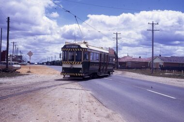
 Ballarat Tramway Museum
Slide - 27 mm sq slide/s - set of 3 - tram stop shelters, Lilian Butler, c1971
... of Sturt St east side of intersection - has Ampol Service station... - Shelter at Ripon St - middle of Sturt St east side of intersection ...Yields information about some of the tramway shelters in Ballarat.Set of Hanimex colour slides in a white cardboard mount of Ballarat tramway shelters. .1 - tramway shelter at Haddon St - note this shelter has been since rebuilt. .2 - Shelter at Ripon St - middle of Sturt St east side of intersection - has Ampol Service station in background. .3 - ditto with the Western Hotel in the view. Photo from the collection of Lilian Butler. ballarat, tramways, trams, shelters, sturt st, ripon st -
 Ballarat Tramway Museum
Slide - 35mm slide/s, Peter Moses, 1/1969?
... . Sebastopol, crossing the highway to the east side of the road. Tram..., Albert St. Sebastopol, crossing the highway to the east side ...Photo of SEC Ballarat No. 39 northbound, Albert St. Sebastopol, crossing the highway to the east side of the road. Tram has destination of "Lydiard St. Nth" and has a SEC "Everything's under control in my all-electric kitchen" roof advertisement. See also Reg. Item 2098, the previous slide. Kodak cardboard mount slide, taken by Peter Moses assumed Jan. 1969.On the rear of the slide "Sebastopol Tram" in black ink "P. Moses" along bottom left hand corner in black ink on the other side of slide.tramways, trams, albert st, sebastopol, tram 39 -
 Ballarat Tramway Museum
Photograph - Digital image, Alwyn Marshall, 1960
... and the photograph shows the cutting wall on the east side of the street... the cutting wall on the east side of the street after the intersection ...Yields information about the appearance of No. 32, Lydiard St North and Macarthur St intersection in 1960.Digital image from the Wal Jack Ballarat Album of a photograph of No 32 southbound in Lydiard St at the intersection with Macarthur St. Has a Milk Bar - shop on the right hand side and the photograph shows the cutting wall on the east side of the street after the intersection. Photo by Alwyn Marshall. Possibly printed by Wal Jack as it has his handwriting on the rear. See image i2 for rear of photograph.On rear of photograph in ink "SEC, Ballarat No. 32 to Sebastopol in Lydiard St Nth at Macarthur St 1960 A. Marshal Photo."trams, tramways, lydiard st nth, macarthur st, tram 32 -
Linton and District Historical Society Inc
Floor plan, Floor plan - Linton State School No. 880
... A3 size photocopy showing floor plan and east side... size photocopy showing floor plan and east side elevation ...A3 size photocopy showing floor plan and east side elevation of Linton State School building. The plan appears to show where new flooring will be required. The number W144563 is written in the top right hand corner. The plan is not clearly dated, however the initials "R. P." followed by the numbers "10/57" suggests that this plan may have been drawn up in 1957.linton state school no. 880, maps and plans, floor plan -
!['Reno', St John's Parade [Kew]](/media/collectors/550653872162f11fb04854aa/items/658d16120f23e8f1e738df53/item-media/658d16680f23e8f1e738e098/item-fit-380x285.jpg) Kew Historical Society Inc
Kew Historical Society IncPhotograph - 'Reno', St John's Parade [Kew], c. 1965
... ‘Reno’, stood on the east side of St John’s Parade. Its... ‘Reno’, stood on the east side of St John’s Parade. Its earliest ...‘Reno’, stood on the east side of St John’s Parade. Its earliest recorded owner was the architect Samuel Cocking who lived there from c.1865 until his death in 1888. The original landholding was bordered by Cotham Road, Glenferrie Road, Wellington Street, and Charles Street. The garden including rare plants supplied by Baron Von Mueller, surrounds the cottage in a tangled frenzy. Despite a ‘local significance’ classification by the National Trust, the house was demolished in 1977.This work forms part of the collection assembled by the historian Dorothy Rogers (1905-1973), donated to the Kew Historical Society by her son in 2015. The manuscripts, photographs, maps, and documents were sourced by her from both family and local collections or produced as references for her print publications. Many were directly used by Rogers in writing ‘Lovely Old Homes of Kew’ (1961) and 'A History of Kew' (1973), or the numerous articles on local history that she produced for suburban newspapers. Most of the photographs in the collection include detailed annotations in her hand. The Rogers Collection provides a comprehensive insight into the working habits of a historian from the 1960s to the 1970s. Original monochrome photograph of Reno, St John's Parade, Kew. Pictured are the garage in the distance at left, the weatherboard house with its simple verandah, and the overgrown front garden.Annotation verso: "Reno. St Johns Parade. Reno. Miss Green".dorothy rogers, reno.-- st john's parade (kew) -
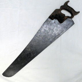 Orbost & District Historical Society
handsaw, C mid 20th century
... River despite the town of Orbost being on the east side... River despite the town of Orbost being on the east side ...The Bairnsdale-Orbost railway was opened in 1916 to serve the agricultural and timber industry. Because of the decline in traffic and heavy operating costs, the line was finally closed in August, 1987. Orbost Railway Station was opened on Monday 10 April 1916 as the terminus of the Orbost railway line, and closed in 1987. The station was located on the west side of the Snowy River despite the town of Orbost being on the east side of the river, in order to save on the costs of a bridge over the river, which at the time had highly variable levels. This item is associated with the history of the Orbost-Bairnsdale railway line and therefore reflects the role that the rail line played in the social and economic history of Orbost.A handsaw with a wooden handle and a metal blade with serrated teeth which continue around the nose of the blade.Marked V an upward pointing arrow Rsaw carpentry orbost-bairnsdale-railway orbost-railway-station -
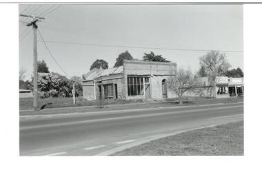 Buninyong & District Historical Society
Photograph - Original B/W Photograph, Former Whyke's Grocer building, Warrenheip St, Buninyong, 18 September 1993
... . Situated East Side of Warrenheip St between Eyre St and Forest St.... Stripped to apricot brickwork. Verandah removed. Situated East Side ...Original building was established by Whyke's family Grocery, built in 1860s. Stripped to apricot brickwork. Verandah removed. Situated East Side of Warrenheip St between Eyre St and Forest St, Buninyong. Building much altered and used as a restaurant in 1970s. Fell into disrepair. Revival took place but not restoration. 1990s under threat of demolition if not conforming to council safety requirements. Building has since been renovated as a pizza restaurant (2023). Vacant lots have since been built on.Established by a prominent local family, an example of a mid 19th century shop. Black and white photo of former Whykes Grocer, 1860's. Streetscape photo of former Whykes Grocer brick building. Power pole with Warrenheip St sign. 3 other shopfronts visible, street trees and vacant land between shops.buninyong, whykes, grocery, building, street scape, warrenheip st -
 Ballarat Tramway Museum
Photograph - Black & White Photograph/s, David Endacott, 14/08/1971 12:00:00 AM
... Victorian houses on the east side of the street in the photograph..... Photo has two Victorian houses on the east side of the street ...Black and white photograph and negative of tram 35 in Drummond St. South, with destination of Sebastopol.. Photo has two Victorian houses on the east side of the street in the photograph. Probably taken 14/8/1971. Duplicate print (1264) by John Phillips 12/99. Two copies (large size) added 5/2001. Original neg scanned at hi res and updated 11/5/2020.trams, tramways, ballarat, drummond st. sth, tram 35 -
 Kew Historical Society Inc
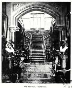
Photograph, The Vestibule, 'Goathland', 1901-1911
... ). The vestibule was entered through a porte-cochère on the east side... on the east side of the house. Visitors entered the mansion through ...'Lost Glories: a memorial to forgotten Australian buildings' was published by David Latta in 1986. It tells the story of a number of significant Australian buildings that had previously been demolished. A chapter in the book was devoted to Goathland, later known as Tara Hall. To supplement the text, he sourced photographs from a range of suppliers, chiefly the Royal Women's Hospital which had once owned Tara Hall, but had sold it in 1960. This is one of the photographs donated to KHS by the author.The Vestibule, Goathland', 1901-11. The vestibule of Tara Hall (originally Byram, and later Goathland and Lowan). The vestibule was entered through a porte-cochère on the east side of the house. Visitors entered the mansion through the vestibule before progressing to the main hallway. The main rooms of the house were accessed through the latter on the ground and first floor. The photograph gives some idea of the decorative style of furnishings during this era. The Vestibule - "Goathland"byram, goathland, tara hall, lowan, studley park (kew), george ramsden, sir malcolm mceacharn, edward george kilburn (architect), studley park road (kew) -
 Vision Australia
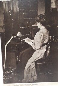
Photograph (item) - Image, Second century display
... Blind Institution, Boomerang Street, Sydney. No.1 workshop, east... Institution, Boomerang Street, Sydney. No.1 workshop, east side ...A series of early twentieth century photographs were sourced and reprinted on to chipboard panels for use by the Royal Blind Society of NSW publicity department, to demonstrate the work and activities that blind people did at the Sydney Industrial Blind Institute (later RBS NSW, now Vision Australia). The source of these photographs is unattributed and the remaining panels of the set have not been located.Working Braille shorthand machine - Panel 11, Photo 13 A corner of the girls' sitting room - a lesson in Braille music (blind pupil and blind teacher) - Panel 1, Photo 2 The Industrial Blind Institution, Boomerang Street, Sydney. No.1 workshop, east side - basketmaking - Panel 2, Photo 3royal blind society of nsw, education, employment