Showing 1518 items matching "evans street"
-
 Hume City Civic Collection
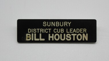
Badge, c1970's
... . The Cubs met in the Old Fire Station (now demolished) in Evans...Hume City Civic Collection 40 Macedon Street Sunbury ...This badge was worn by Bill Houston when he became Sunbury District Cub Leader whilst with the 1st Sunbury Cubs in the 1970's. The Cubs met in the Old Fire Station (now demolished) in Evans Street, Sunbury.A small black plastic badge with Bill Houston's name on it."SUNBURY/DISTRICT CUB LEADER/Bill Houston"1970s, houston, william, joan, 1st sunbury cubs, george evans collection -
 Surrey Hills Historical Society Collection
Photograph, 6a Thistle Street, Surrey Hills, 1924
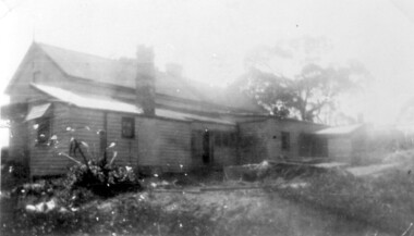
... Evans, father of Mrs Lillian Austin. The Evans family came from ...One of the oldest homes in Surrey Hills. The photo was taken in 1924 when the property was purchased by Mr John Francis Evans, father of Mrs Lillian Austin. The Evans family came from Gembrook. John Evans was born in Wales; he and his wife Mary had 3 children, 2 daughters and one son. Mary Evans pre-deceased her husband, who died on 23 October 1924 at Hillsborough, 6A Thistle Street. The first owner of the property was Mrs Rachel Sweetnam (nee Lewis) who married Thomas Edward Sweetnam on 24 September 1884 at St John's Church, Camberwell. REF: THE ARGUS 4 Oct 1884 Thomas second eldest surviving son of Matthew Sweetnam married to Rachel (Ray) third eldest daughter of Captain T.D. Lewis, Culm Haven, Camberwell. Thomas was active in land sales and variously described as a land agent, real estate agent and auctioneer. The property - Hillsboro or Hillsborough - was originally a house on a farm of 10 acres owned by her. It became 6A Thistle Street. According to the Alan Holt property register Rachel Sweetnam owned the property prior to 1890 and a family tree on Ancestry.com has that it was owned by her in c1886. It is likely that at this stage the property was an investment rather than the Sweetnam's family residence. Other property owners or residents are: 1890 Selina Gaylor 1900 Stephen Pullen 1910 William Murray (draftsman) 1920 George C Hughes 1930 Arthur Leslie Austin (tram driver) 1980 Mrs Lillian Evelyn Austin Lillian Austin died on 19 August 1983 and the property was sold that year for $87,000. The house is still extant (January 2025). Note that we also have material / photos regarding George Hughes and family.Black and white photo of a timber home with brick chimneys and a (?) corrugated iron roof. There are sheds and outbuildings attached to the house. The garden looks untended. In the background a mature eucalypt tree can be seen.houses, hillsboro, timber houses, mrs lillian austin, hillsborough, selina gaylor, stephen pullen, william murray, george hughes, arthur austin, john francis evans, thistle street -
 Hume City Civic Collection
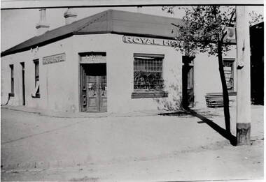
Photograph, Royal Hotel
... building which was on the corner of Brook and Evans Streets... building which was on the corner of Brook and Evans Streets ...This is an image of the original single storey Royal Hotel building which was on the corner of Brook and Evans Streets. In the 1930s the single storey structure was demolished after a fire and replaced with a double storey Art Deco red brick building, which still stands on the same site.At one stage there were four hotels in Evans Street between Station Street and Brook Street. At some stage the Millett family owned them. The Royal and the Olive Tree (formerly the Railway) hotels remain on their original site but not in their original appearance.A black and white photograph with a cream border of a single storey hotel building with a headlight window on the RHS of the corner entry doorway, which also has lead light windows. A young tree and power pole are seen on the RHS of the image. hotels, royal hotel, s.winter, t. millett -
 Sunbury Family History and Heritage Society Inc.
Photograph
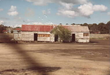
... moved from their sports ground in Evans Street to the new... from their sports ground in Evans Street to the new recreation ...The buildings were used as clubrooms by the Sunbury Football Club when in 1953 Sunbury Football and Cricket Clubs moved from their sports ground in Evans Street to the new recreation ground in Riddell Road (Clarke Oval). Newer club rooms were opened at a later date.A scanned non-digital coloured photograph of two old weatherboard buildings erected in an open area. Some houses and trees are visible in the middle distance.clarke oval, sunbury football club, sunbury cricket club, clubrooms -
 Sunbury Family History and Heritage Society Inc.
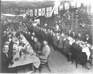
Photograph, World War 1 defence forces, 1918
... in Evans Street. ... in Evans Street. At the end of World War 1, the local Sunbury ...The photograph was taken some time after the end of World War 1. It was a Welcome Home reception for those men who had enlisted to fight in World War 1 and were lucky to return home. The reception took place in the Sunbury Fire Station which was located in Evans Street. At the end of World War 1, the local Sunbury community held a number of Welcome Home receptions to acknowledge the part played by many local men and women in World War 1.A non-digital black and white copy of a photograph of a lot of men at a reception seated at long tables in a large hall. There are flags from a number of countries festooned across the room. welcome home receptions, world war 1, sunbury, defence forces -
 Flagstaff Hill Maritime Museum and Village
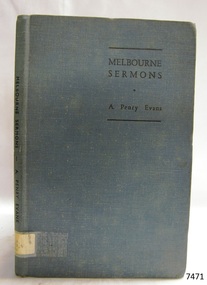
Book, Melbourne Sermons
... Melbourne Sermons Author: Rev. A Penry Evans Publisher...Flagstaff Hill Maritime Museum and Village 89 Merri Street ...Melbourne Sermons Author: Rev. A Penry Evans Publisher: Collins Street Independant Church Date: 1946Label on spine cover with typed text RA 252.4 EVA warrnambool, shipwrecked-coast, flagstaff-hill, flagstaff-hill-maritime-museum, maritime-museum, shipwreck-coast, flagstaff-hill-maritime-village, shipwrecked-artefact, book, melbourne sermons, rev. a penry evans -
 Sunbury Family History and Heritage Society Inc.
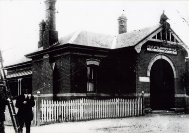
Photograph, c 1900s
... and residence, which was built on the corner of Brook and Evans Street..., which was built on the corner of Brook and Evans Street in 1892 ...The building is the Sunbury Post and Telegraph Office and residence, which was built on the corner of Brook and Evans Street in 1892. Prior to that time the postal service ion Sunbury was conducted at the railway station. Over the years changes and extensions have taken place to the building to accommodate it for modern postal delivery practices although it still operates from the same site.The Sunbury Post Office has operated in a building on the same site since 1892 despite many changes and extensions made to the building, which included the demolition of the residence attached to the original building.A black and white photograph of Victorian style brick building with a slate roof with 3 chimneys and surrounded by a white picket fence. Two men are standing by a ladder on the LHS of the image. sunbury, sunbury post office, post and telegraph offices -
 Hume City Civic Collection
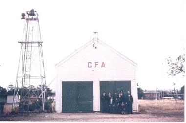
Photograph, Early 1970s
... The old Sunbury CFA station was situated in Evans Street... melbourne The old Sunbury CFA station was situated in Evans Street ...The old Sunbury CFA station was situated in Evans Street where part of the Sunbury Shopping Square has been built. It was opened on that site in 1914. In 1969 a newer fire station was built in Evans Street on the opposite side of the road and closer to Macedon Street. From 1969 until 1978 the old fire station became a scout hall. In the early 2000s two new fire stations were built away from the main shopping area. One was built in Jackson Street, opposite the Ball Court Hotel and the other one was built on the corner of Gap Road and Elizabeth Drive. By locating them out of the immediate shopping centre which had become quite busy, it meant that access in and out of the new stations was quicker. The butter factory in Horne Street is on the RHS and the former public tennis courts are on the LHS of the photograph.A coloured photograph of the CFA firemen standing outside the former CFA building. The bell tower is on the LHS of the building.country fire authority, fire fighters, sunbury fire station, butter factory, tennis courts, george evans collection -
 Port Melbourne Historical & Preservation Society
Photograph - Launch of History of a Street Precinct, 25 Sep
... the 1880s to 1960. The area is bounded by Evans Street, the E side.... The area is bounded by Evans Street, the E side of Bridge Street, S ...In 2005, members of the PMH&PS undertook a study of the residents of the houses in a Port Melbourne street precinct from the 1880s to 1960. The area is bounded by Evans Street, the E side of Bridge Street, S side of Williamstown Road, Farrell Street both the E & W sides plus the section of Ross Street between Farrell and Bridge and the part of Derham Street between Farrell and Bridge. The resulting map and an interactive CD won the Best Community Research, Registers & Records project at the 2007 Victorian Community History Awards. The project was launched on the railway reserve near the corner of Evans & Farrell streets. Co-author Graham BRIDE.Co-author, Graham Bride, at the launch of the History of a Street Precinct25/9/05 Graham Bridehistory of a street precinct, graham bride -
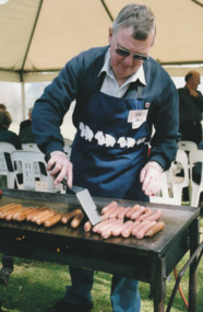 Port Melbourne Historical & Preservation Society
Photograph - Launch of History of a Street Precinct, 25 Sep
... the 1880s to 1960. The area is bounded by Evans Street, the E side.... The area is bounded by Evans Street, the E side of Bridge Street, S ...In 2005, members of the PMH&PS undertook a study of the residents of the houses in a Port Melbourne street precinct from the 1880s to 1960. The area is bounded by Evans Street, the E side of Bridge Street, S side of Williamstown Road, Farrell Street both the E & W sides plus the section of Ross Street between Farrell and Bridge and the part of Derham Street between Farrell and Bridge. The resulting map and an interactive CD won the Best Community Research, Registers & Records project at the 2007 Victorian Community History Awards. The project was launched on the railway reserve near the corner of Evans & Farrell streets. Jack BOLT is cooking with Ken TURNER in the background.Jack Bolt cooking sausages at the launch of the History of a Street Precinct25/9/05 Jack Bolt 11jack bolt, ken turner, history of a street precinct -
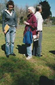
 Port Melbourne Historical & Preservation Society
Photograph - Launch of History of a Street Precinct, 25 Sep
... the 1880s to 1960. The area is bounded by Evans Street, the E side.... The area is bounded by Evans Street, the E side of Bridge Street, S ...In 2005, members of the PMH&PS undertook a study of the residents of the houses in a Port Melbourne street precinct from the 1880s to 1960. The area is bounded by Evans Street, the E side of Bridge Street, S side of Williamstown Road, Farrell Street both the E & W sides plus the section of Ross Street between Farrell and Bridge and the part of Derham Street between Farrell and Bridge. The resulting map and an interactive CD won the Best Community Research, Registers & Records project at the 2007 Victorian Community History Awards. The project was launched on the railway reserve near the corner of Evans & Farrell streets. LL - R - unknown, Pat GRAINGER, Graham BRIDE.Pat GRAINGER, Graham BRIDE at the launch of the History of a Street Precinct project. 25/9/05 Not Known, Pat Grainger, Graham Bridepat grainger, graham bride, history of a street precinct -
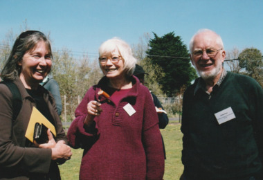
 Port Melbourne Historical & Preservation Society
Photograph - Launch of History of a Street Precinct, 25 Sep
... the 1880s to 1960. The area is bounded by Evans Street, the E side.... The area is bounded by Evans Street, the E side of Bridge Street, S ...In 2005, members of the PMH&PS undertook a study of the residents of the houses in a Port Melbourne street precinct from the 1880s to 1960. The area is bounded by Evans Street, the E side of Bridge Street, S side of Williamstown Road, Farrell Street both the E & W sides plus the section of Ross Street between Farrell and Bridge and the part of Derham Street between Farrell and Bridge. The resulting map and an interactive CD won the Best Community Research, Registers & Records project at the 2007 Victorian Community History Awards. The project was launched on the railway reserve near the corner of Evans & Farrell streets. L- R - Natica SCHROEDER, Pat GRAINGER, Janet BOLITHO.Three members of the PMHPS the launch of the History of a Street Precinct25/9/05 Natica Schroeder, Pat Grainger, Janet Bolithohistory of a street precinct, pat grainger, natica schroeder, janet bolitho -
 Port Melbourne Historical & Preservation Society
Photograph - Launch of History of a Street Precinct, 25 Sep
... the 1880s to 1960. The area is bounded by Evans Street, the E side.... The area is bounded by Evans Street, the E side of Bridge Street, S ...In 2005, members of the PMH&PS undertook a study of the residents of the houses in a Port Melbourne street precinct from the 1880s to 1960. The area is bounded by Evans Street, the E side of Bridge Street, S side of Williamstown Road, Farrell Street both the E & W sides plus the section of Ross Street between Farrell and Bridge and the part of Derham Street between Farrell and Bridge. The resulting map and an interactive CD won the Best Community Research, Registers & Records project at the 2007 Victorian Community History Awards. The project was launched on the railway reserve near the corner of Evans & Farrell streets. L- R - Val POWER, Jim POWER.Two members of the PMHPS the launch of the History of a Street Precinct25/9/05 Val Power, Jim Powerhistory of a street precinct, val power, jim power -
 Port Melbourne Historical & Preservation Society
Photograph - Launch of History of a Street Precinct, 25 Sep
... the 1880s to 1960. The area is bounded by Evans Street, the E side.... The area is bounded by Evans Street, the E side of Bridge Street, S ...In 2005, members of the PMH&PS undertook a study of the residents of the houses in a Port Melbourne street precinct from the 1880s to 1960. The area is bounded by Evans Street, the E side of Bridge Street, S side of Williamstown Road, Farrell Street both the E & W sides plus the section of Ross Street between Farrell and Bridge and the part of Derham Street between Farrell and Bridge. The resulting map and an interactive CD won the Best Community Research, Registers & Records project at the 2007 Victorian Community History Awards. The project was launched on the railway reserve near the corner of Evans & Farrell streets. L- R - Robyn ?, Maralyn KOBELTMaralyn & Robin at the launch of the History of a Street Precinct25/9/05 Robyn ?, Maralyn Kobelthistory of a street precinct, maralyn kobelt -
 Port Melbourne Historical & Preservation Society
Photograph - Launch of History of a Street Precinct, 25 Sep
... the 1880s to 1960. The area is bounded by Evans Street, the E side.... The area is bounded by Evans Street, the E side of Bridge Street, S ...In 2005, members of the PMH&PS undertook a study of the residents of the houses in a Port Melbourne street precinct from the 1880s to 1960. The area is bounded by Evans Street, the E side of Bridge Street, S side of Williamstown Road, Farrell Street both the E & W sides plus the section of Ross Street between Farrell and Bridge and the part of Derham Street between Farrell and Bridge. The resulting map and an interactive CD won the Best Community Research, Registers & Records project at the 2007 Victorian Community History Awards. The project was launched on the railway reserve near the corner of Evans & Farrell streets. Darren Ray, Mayor of City of Port Phillip.City of Port Phillip mayor, Cr Darren Ray at the launch of the History of a Street Precinct25/9/05 Darren Ray Mayor CoPPhistory of a street precinct, darren ray -
 Port Melbourne Historical & Preservation Society
Photograph - Launch of History of a Street Precinct, 25 Sep
... the 1880s to 1960. The area is bounded by Evans Street, the E side.... The area is bounded by Evans Street, the E side of Bridge Street, S ...In 2005, members of the PMH&PS undertook a study of the residents of the houses in a Port Melbourne street precinct from the 1880s to 1960. The area is bounded by Evans Street, the E side of Bridge Street, S side of Williamstown Road, Farrell Street both the E & W sides plus the section of Ross Street between Farrell and Bridge and the part of Derham Street between Farrell and Bridge. The resulting map and an interactive CD won the Best Community Research, Registers & Records project at the 2007 Victorian Community History Awards. The project was launched on the railway reserve near the corner of Evans & Farrell streets. Janet BOLITHO, former mayor of City of Port Phillip.Former City of Port Phillip mayor, Janet Bolitho, at the launch of the History of a Street Precinct25/9/05 Janet Bolithohistory of a street precinct, janet bolitho -
 Port Melbourne Historical & Preservation Society
Photograph - Launch of History of a Street Precinct, 25 Sep
... the 1880s to 1960. The area is bounded by Evans Street, the E side.... The area is bounded by Evans Street, the E side of Bridge Street, S ...In 2005, members of the PMH&PS undertook a study of the residents of the houses in a Port Melbourne street precinct from the 1880s to 1960. The area is bounded by Evans Street, the E side of Bridge Street, S side of Williamstown Road, Farrell Street both the E & W sides plus the section of Ross Street between Farrell and Bridge and the part of Derham Street between Farrell and Bridge. The resulting map and an interactive CD won the Best Community Research, Registers & Records project at the 2007 Victorian Community History Awards. The project was launched on the railway reserve near the corner of Evans & Farrell streets. L - R - Unknown, Norah HOWARD, Mayor Darren RAY.CoPP mayor and PMHPS members at the launch of the History of a Street Precinct25/9/05 Not known, Norah Howard, Darren Ray, Mayorhistory of a street precinct, darren ray, norma howard -
 Port Melbourne Historical & Preservation Society
Photograph - Launch of History of a Street Precinct, 25 Sep
... the 1880s to 1960. The area is bounded by Evans Street, the E side.... The area is bounded by Evans Street, the E side of Bridge Street, S ...In 2005, members of the PMH&PS undertook a study of the residents of the houses in a Port Melbourne street precinct from the 1880s to 1960. The area is bounded by Evans Street, the E side of Bridge Street, S side of Williamstown Road, Farrell Street both the E & W sides plus the section of Ross Street between Farrell and Bridge and the part of Derham Street between Farrell and Bridge. The resulting map and an interactive CD won the Best Community Research, Registers & Records project at the 2007 Victorian Community History Awards. The project was launched on the railway reserve near the corner of Evans & Farrell streets. L - R - Unknown, Janet BOLITHO, Glen STUART.CoPP mayor and PMHPS members at the launch of the History of a Street Precinct25/9/05 Not known, Janet Bolitho, Glen Stuarthistory of a street precinct, janet bolitho, glen stuart -
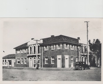 Sunbury Family History and Heritage Society Inc.
Photograph, The Royal Hotel, c1939
... on the corner of Brook and Evans Streets in Sunbury's main shopping... on the corner of Brook and Evans Streets in Sunbury's main shopping ...The two storey building is the Royal Hotel which is sited on the corner of Brook and Evans Streets in Sunbury's main shopping strip.The photograph was taken sometime in 1939 after it was totally rebuilt. A fire had damaged the old single storey structure, which was built on the same site c1860 shortly after Sunbury had a rail service. The building still operates today on the same site.The Royal Hotel is one of four hotels that were built in Evans Street Sunbury between Brook and Station Streets ion the 1860s shortly after the rail service arrived in the town. They were They were the Railway Hotel (Olive Tree), White Horse Hotel, Royal Hotel and the Rupertswood Hotel, opposite the Royal Hotel. A non-digital black and white photograph with a cream border of a two storey brick hotel building with light concrete trimming around the windows and entrances sited on a corner. A large black sedan car is parked near the corner. royal hotel, hotels -
 Port Melbourne Historical & Preservation Society
Photograph - Launch of History of a Street Precinct, 25 Sep
... the 1880s to 1960. The area is bounded by Evans Street, the E side.... The area is bounded by Evans Street, the E side of Bridge Street, S ...In 2005, members of the PMH&PS undertook a study of the residents of the houses in a Port Melbourne street precinct from the 1880s to 1960. The area is bounded by Evans Street, the E side of Bridge Street, S side of Williamstown Road, Farrell Street both the E & W sides plus the section of Ross Street between Farrell and Bridge and the part of Derham Street between Farrell and Bridge. The resulting map and an interactive CD won the Best Community Research, Registers & Records project at the 2007 Victorian Community History Awards. The project was launched on the railway reserve near the corner of Evans & Farrell streets. Liana ThOMPSON is with her mother , Fay BATES/ SHAW nee DEVINE.Liana Thompson & Fay Bates the launch of the History of a Street Precinct. 25/9/05 Liana Thompson, Fay Bates (previously Shaw nee Devine)liana thompson, fay bates, history of a street precinct -
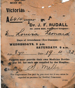 Port Melbourne Historical & Preservation Society
Card - Hospital Eye appointment card, 1922
... Evans Street, Port Melbourne. Louisa was 8 years old, and her... the mantlepiece when the donor was renovating 128 Evans Street, Port ...The hospital eye appointment card for Louisa LEONARD was found behind the mantlepiece when the donor was renovating 128 Evans Street, Port Melbourne. Louisa was 8 years old, and her hospital number was A6414. Regular appointments are listed from April to June 1922 under the names of Dr J F RUDALL and his Assistant Surgeon, Dr John BOX. The consultation fee was one shilling and patients had to provide their own Medicine Bottles or pay three pence for one from the hospital. Handwritten name on front and appointment details on the reverse.health - hospitals, louisa leonard, dr j f rudall, dr john box -
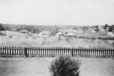 Greensborough Historical Society
Photograph - Digital image, View from 11 Anama Street Greensborough, 1949c
... the Evans home at 11 Anama Street. anama street evans family june ...View of Greensborough from the Evans home at 11 Anama Street.Digital copy of black and white photographanama street, evans family, june evans, june hall nee evans -
 Kew Historical Society Inc
Plan - Subdivision Plan, Jas R Mathers Son & McMillan, Macartney Estate, East Kew, c. 1925
... plans - east kew macartney estate Macartney Street Mount Street ...Pru Sanderson, in her groundbreaking ‘City of Kew Urban Conservation Study : Volume 2 - Development History’ (1988), summarised the periods of urban development and subdivisions of land in Kew. The periods that she identified included 1845-1880, 1880-1893, 1893-1921, 1921-1933, 1933-1943, and Post-War Development. These periods were selected as they represented periods of rapid growth or decline in urban development. An obvious starting point for Sanderson’s groupings involved population growth and the associated economic cycles. These cycles also highlighted urban expansion onto land that was predominantly rural, although in other cases it represented the decline and breakup of large estates. A number of the plans in the Kew Historical Society’s collection can also be found in other collections, such as those of the State Library of Victoria and the Boroondara Library Service. A number are however unique to the collection.Subdivision plans are historically important documents used as evidence of the growth of suburbs in Australia. They frequently provide information about when the land was sold on which a built structure was subsequently constructed as well as evidence relating to surveyors and real estate and financial agents. The numerous subdivision plans in the Kew Historical Society's collection represent working documents, ranging from the initial sketches made in planning a subdivision to printed plans on which auctioneers or agents listed the prices for which individual lots were sold. In a number of cases, the reverse of a subdivision plan in the collection includes a photograph of a house that was also for sale by the agent. These photographs provide significant heritage information relating house design and decoration, fencing and household gardens.The Macartney Estate subdivision advertised 21 lots for sale on either side of Macartney Street (now Macartney Avenue) and Evans Road in what was then designated as East Kew. Most of the houses shown on the south side of Macartney Street then, as now, have rear entrances on Mount Street, however a number of these blocks have since been further subdivided to allow for the building of new houses on the rear of a block. Brougham Place is marked on the plan but is now called Daniell Place."C"subdivision plans - east kew, macartney estate, macartney street, mount street, evans road, brougham place -
 Port Melbourne Historical & Preservation Society
Photograph - Launch of History of a Street Precinct, 25 Sep
... the 1880s to 1960. The area is bounded by Evans Street, the E side.... The area is bounded by Evans Street, the E side of Bridge Street, S ...In 2005, members of the PMH&PS undertook a study of the residents of the houses in a Port Melbourne street precinct from the 1880s to 1960. The area is bounded by Evans Street, the E side of Bridge Street, S side of Williamstown Road, Farrell Street both the E & W sides plus the section of Ross Street between Farrell and Bridge and the part of Derham Street between Farrell and Bridge. The resulting map and an interactive CD won the Best Community Research, Registers & Records project at the 2007 Victorian Community History Awards. The project was launched on the railway reserve near the corner of Evans & Farrell streets. l - R - Mayor Darren RAY, David THOMPSON, Margaret BRIDE, Janet BOLITHO, Graham BRIDE.CoPP mayor and PMHPS members involved in the production at the launch of the History of a Street Precinct25/9/05 Mayor, David Thompson, Margaret Bride, Janet Bolitho, Graham Bridehistory of a street precinct, darren ray, graham bride, margaret bride, janet bolitho, david thompson -
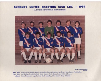 Sunbury Family History and Heritage Society Inc.
Photograph, Astra Studios, Sunbury United Sporting Club Ltd. 1981, 1981
... played on the Aussies Rules ground in Evans Street (now... played on the Aussies Rules ground in Evans Street (now ...As a result of a group of European expatriates settling in Sunbury in the 1970s and wanting to play soccer, the Sunbury United Sporting Club was formed in 1972 with the first games played on the Aussies Rules ground in Evans Street (now the Sunbury Shopping Square). After cooperation between Shire of Bulla Council to acquire an open area of land in Michells Lane, the club moved to their own ground, Langama Park in 1975. Since that date, the club has grown and today there are 3 senior and 2 junior pitches as well as 2 cricket pitches and comfortable clubrooms on the area.Sunbury United Sporting Club was one of the first Soccer Clubs to be established in the district.A scanned non-digital coloured photograph of the Sunbury United Football Club. There is a white border around the photograph and the names of the players are listed under the image. The players are wearing navy blue guernseys with a diagonal red and white stripe across the front.sunbury united sporting club., langhama park, soccer, mitchells lane -
 Sunbury Family History and Heritage Society Inc.
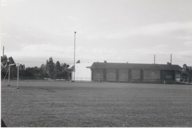
Photograph, Lamgama Park - Soccer Pitch, C 1970s
... reserve in Evans Street on the ground designed for AFL football... reserve in Evans Street on the ground designed for AFL football ...Sunbury United Soccer Club was established in 1973 by a group of expatriate Europeans who wanted to play the game they grew up with. Their first games were played on the recreation reserve in Evans Street on the ground designed for AFL football. (Now the site of a shopping complex). In August 1975, Sunbury United moved to its present home on seven and a half acres of sporting ground at Langama Park in Mitchells Lane . Over the years that area has developed and there are now three senior, and two junior soccer pitches with two cricket pitches and practice nets. Although there is still room for improvement to the floodlighting on the main pitch, the night games have proven successful. The Sunbury United Soccer Club has played an important roll in district competition and is one of the many sporting clubs in Sunbury.A non-digital black and white photograph of a soccer ground showing a set of goal posts with the clubrooms and change rooms in the background.soccer, sunbury united soccer club, football, langama park, mitchells lane -
 Port Melbourne Historical & Preservation Society
Sign - Farrell St West, c. 1980
... on corner Evans and Farrell Streets. Removed from house circa 1980... Evans and Farrell Streets. Removed from house circa 1980 built ...Originally on side wall of house of Ruby Mary Blair. House on corner Evans and Farrell Streets. Removed from house circa 1980Oblong blue sign with "Farrell St : West " in white letteringFarrell St : Westbuilt environment - street furniture, engineering - roads streets lanes and footpaths, ruby mary blair, farrell street -
Port Melbourne Historical & Preservation Society
Document - Town of Port Melbourne, Sand Receipt Book, 1907
... moneys received by C W Hill for sand sold at Evans and Station... Melbourne Town Hall 333 Bay Street Port Melbourne melbourne local ...Town of Port Melbourne. Sand receipt book, recording moneys received by C W Hill for sand sold at Evans and Station street Reserves from July 8 to August 1, 1907local government - town of port melbourne, natural environment - beaches and foreshore -
 Hume City Civic Collection
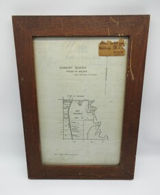
Plans, SUNBURY RESERVE PARISH OF HOLDEN
... at Munro's. This was unfenced land between Evans and Barkly Streets... at Munro's. This was unfenced land between Evans and Barkly Streets ...This object is a plan of a proposed recreation ground at Munro's. This was unfenced land between Evans and Barkly Streets adjacent to the Asylum boundary, now Jacksons Hill.A wooden framed plan of a proposed recreation ground.sunbury, sunbury asylum, george evans collection -
 Warrnambool and District Historical Society Inc.
Document - Warrnambool City Council Preliminary Report Industrial Estate West Warrnambool, E Johnson, 9 March 1973
... Road, on the East by Scott Street, on the South by Evans Street... Road, on the East by Scott Street, on the South by Evans Street ...This preliminary report relates to 32½ acres of council owned land in West Warrnambool bounded on the North by McMeekin Road, on the East by Scott Street, on the South by Evans Street and on the West by the rear boundaries of properties facing Landmann and Granter Streets. In 2010, West Warrnambool was the largest of Warrnambool’s existing industrial areas, comprising approximately 109ha of industrial zoned land, the majority of which (101ha) is zoned IN1Z, with the remainder zoned INZ3. The area comprises a mixture of lot sizes supporting a diverse mix of industries. Larger parcels are occupied by the abattoirs, scrap metal industries, freight, the Council Depot and storage. Smaller lots are occupied by smaller manufacturers and wholesalers and service industries. [Ref: Warrnambool Industrial Land Use Review. Mesh Pty Ltd July 2010]This document is a preliminary report prepared by the Warrnambool City Council Engineer in March 1973 and provides an example of the planning process undertaken to develop one of Warrnambool's industrial areas. It contains details and costings of the proposed subdivision. Two foolscaps size pages of typewritten information. A detailed topographical map of the area with areas highlighted in blue, red, green, blue and purple pen.warrnambool city council, west warrnambool, industrial estate