Showing 247 items matching "grey border"
-
 Essendon Football Club
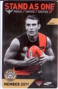
Plastic membership ticket, 2011
... Plastic membership ticket; front has action photo of Jobe Watson in an Essendon jumper holding a football; "Stand as One Proud/ United / Excited" in red and grey text at top of card; small bronze strip with "scarf" in black text on right edge; small circle in bottom left corner has Essendon bomber logo in centre and "Bronze member" in black letters around bronze border; "Member 2011" in black text on bronze background below it; small Essendon and Samsung logos in bottom right corner. ...Essendon Football Club 275 Melrose Drive Tullamarine melbourne Essendon Football Club Plastic membership ticket; front has action photo of Jobe Watson in an Essendon jumper holding a football; "Stand as One Proud/ United / Excited" in red and grey text at top of card; small bronze strip with "scarf" in black text on right edge; small circle in bottom left corner has Essendon bomber logo in centre and "Bronze member" in black letters around bronze border; "Member 2011" in black text on bronze background below it; small Essendon and Samsung logos in bottom right corner. ...Plastic membership ticket; front has action photo of Jobe Watson in an Essendon jumper holding a football; "Stand as One Proud/ United / Excited" in red and grey text at top of card; small bronze strip with "scarf" in black text on right edge; small circle in bottom left corner has Essendon bomber logo in centre and "Bronze member" in black letters around bronze border; "Member 2011" in black text on bronze background below it; small Essendon and Samsung logos in bottom right corner. Reverse has bar code and "2011 Adult Bronze" and "Year member 19" in stylised logo in top right corner plus details of member and reserved seats.essendon football club -
 Essendon Football Club
VFL premiership medal in display box, 1901 (medal)
... border. Medal has small loop at top which has a small metal ring through it; royal blue silk ribbon (not original) has been passed through ring. Medal is in a black leather case with clear plastic top, lined with grey suede, with a metal lock at front. ...border. Medal has small loop at top which has a small metal ring through it; royal blue silk ribbon (not original) has been passed through ring. Medal is in a black leather case with clear plastic top, lined with grey suede, with a metal lock at front. ...Medal was awarded to Bill Griffith as a member of the victorious Essendon premiership team in 1901; put into presentation case by Jack Griffith, Bill's sonCircular gold 1901 VFL premiership medal. Engraved "VFL" logo has been cut out in centre of circle leaving a thin border; "Essendon F. C." engraved on top part of border, "Premiers 1901" engraved on bottom part of border. Reverse has"Griffiths" [sic] engraved on top part of border. Medal has small loop at top which has a small metal ring through it; royal blue silk ribbon (not original) has been passed through ring. Medal is in a black leather case with clear plastic top, lined with grey suede, with a metal lock at front. Gold metal panel has been attached to bottom edge of case top with "Donated by Jack Griffith" in black letters. Two more gold metal plaques have been attached to glass from the inside with grey plastic tape; top plaque has "1901 premiership medallion" in black text, and bottom plaque has " "Griffith, William (Ess.) - 1899-1913" with details of his career in black text. Black and white photocopied photo of Griffith has been attached to bottom of case next to the medal. Key to the lock is also in the case.Engraved "VFL" logo has been cut out in centre of circle leaving a thin border; "Essendon F. C." engraved on top part of border, "Premiers 1901" engraved on bottom part of border. Reverse has"Griffiths" [sic] engraved on top part of border.griffith, bill; essendon football club, vfl premierships, premiership medals -
 National Vietnam Veterans Museum (NVVM)
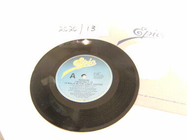
Audio - Record, Vinyl, I Was Only 19, 1983
... A 45rpm record in grey paper cover with Epic in yellow fancy writing on blue paper. Also in dark blue ink are the details of the record. the label is has a white border around it. ...Aust Composition A 45rpm record in grey paper cover with Epic in yellow fancy writing on blue paper. Also in dark blue ink are the details of the record. the label is has a white border around it. ...A 45rpm record in grey paper cover with Epic in yellow fancy writing on blue paper. Also in dark blue ink are the details of the record. the label is has a white border around it. On Side A: Redgum: "I was Only 19 (A Walk In the Light Green). On Side B: Redgum, Yarralumba Wine"John Schumann, Redgum Music. Produced by Trevor Lucas. Aust Performance. Aust Compositionentertainment, record, music -
B-24 Liberator Memorial Restoration Australia Inc
Oral History, Arthur Cambell Williams History
... Black printed Arthur Cambell Williams History on grey paper with fancy black border...Black printed Arthur Cambell Williams History on grey paper with fancy black border A4 perspex covered, bound typed copy Arthur Cambell Williams History Oral History ...Arthur Williams was in the RAAF from13/10/1940 until April 1946 and was a radar operator between February 1945 and April 1946.The oral history of Arthur Williams is of historical significance because it provides a first hand account of the individual's experience during WW11 as a member of the RAAF who trained at Tocumwal.He saw active service in the Pacific conflict from Leyburn and Morotai as a radar operator on a B24 Liberator supporting Z Force.A4 perspex covered, bound typed copyBlack printed Arthur Cambell Williams History on grey paper with fancy black border -
 Embroiderers Guild, Victoria
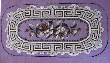
Textile - Panel (unfinished), Late 19th century
... Oval panel - design is of roses with a geometric border in mauve, grey, black, gold and brown beads on mauve penelope canvas. ...Beadwork Late 19th century Oval panel - design is of roses with a geometric border in mauve, grey, black, gold and brown beads on mauve penelope canvas. ...Piece came to the Guild with a bag of canvas pieces from a deceased estate for disposal to members.Oval panel - design is of roses with a geometric border in mauve, grey, black, gold and brown beads on mauve penelope canvas. Intended as an inset for a tray.beadwork, late 19th century -
 Ballarat Tramway Museum
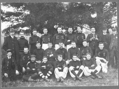
Photograph - Block Mounted Photograph, Owen Photo, c1910
... Ballarat" Block mounting, dark grey colour has rounded corners, has thick outer border of stippled cardboard....Ballarat" Block mounting, dark grey colour has rounded corners, has thick outer border of stippled cardboard. ...Black and white block mounted photograph of the ESCo Ballarat Football team, with about half in "ES" jumpers, some in tramway uniform and some in formal clothes. See also Reg. Items 2939, 2940 for other photos with Bill Gunn, identified in writing on rear. Note: Could not see name in Employees Register, but not all register searched. On rear has a green round label, with name of studio in white - "Own Photo Dana St. Ballarat" Block mounting, dark grey colour has rounded corners, has thick outer border of stippled cardboard.On rear in ink "Centre front, William 'Bill' Gunn / taken before 1910 / about 22 when he died." and "Front left Bob Haines"trams, tramways, esco, tram crews, football, ballarat -
 Ballarat Tramway Museum
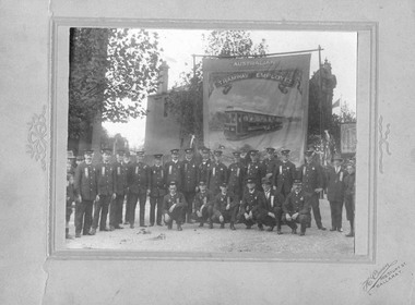
Photograph - Black and White photograph/s - mounted
... Mounting is an embossed cardboard with a raised border and different filigree on either side of the boarder. Cardboard has a light grey colour finish. ...Mounting is an embossed cardboard with a raised border and different filigree on either side of the boarder. Cardboard has a light grey colour finish. ...Mounted black and white photograph of 19 uniformed ESCo employees and two or three non-uniformed employees in front of the Australian Tramway Employees Association (Employees) Banner possibly at the time of a Union or Labor Day Parade, Ballarat. Photograph 145H x 189W. The banner contains a painted image of Prahran and Malvern Municipal Tramways, (PMTT) C class No. 30. Date - 1914? Image 1 of the photograph and part of the mounting. Mounting is an embossed cardboard with a raised border and different filigree on either side of the boarder. Cardboard has a light grey colour finish. On the bottom right hand side is the photographers name "T.C. Owen, 609 Sturt St. Ballarat". Image 2 - mounting and photograph showing general condition of the mounting. See Tramways of the Golden City (Ballarat History) notes AETA formed November 1910.On rear in pencil "9095" in pencil in the middle of the mounting and "1914" in ink on the right hand upper side of the mounting.trams, tramways, atea, unions, parades, esco -
 National Wool Museum
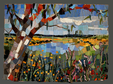
Textile - Community Textile Tapestry, Lisa Kendal et al, WARM, 2016
... In the foreground of the coal mine painting is the same gum tree described in the tapestry; however, it is grey and sickle with only 4 leaves visible at the top border, compared to the numerous leaves in the tapestry. ...In the foreground of the coal mine painting is the same gum tree described in the tapestry; however, it is grey and sickle with only 4 leaves visible at the top border, compared to the numerous leaves in the tapestry. ...WARM was a community textile art project that saw over 250 knitters come together to create a beautiful collage tapestry. Made entirely from wool, the artwork contains more than 1000 individual hand knitted sections. The project takes aim at global warming, it highlights both the causes and solutions for us to create a sustainable and safe climate for future generations. Lisa Kendal, the co-creator of the project, said “One of the problems in the world is that we have forgotten how to warm ourselves with wool. We have become too dependent on fossil fuels (for heating)”. This is the key idea surrounding the project. WARM began as two large scale images created by Lars Stenberg. The first image is a landscape scarred by coal mining. The second image is the same landscape only many decades later. Regeneration and regrowth have taken over the landscape and hidden the past coal mine completely. In its place is a beautiful landscape including trees, native flowers, a lake, lots of greenery and wind turbines. From March to the end of August in 2016, knitters worked hard to create the over one thousand pieces that came together to form the final tapestry. The pieces were all designed by Fibre Artist Georgie Nicolson of Tikki Knitting Designs, who converted the second image of the healed landscape into patterns for the 250 plus knitters to follow. These patterns included unusual designs such as gum leaves, trees, native flowers and even the wind turbines. During several days of installation, the knitted pieces were stitched together by Lars Stenberg over a picture of the first image of the operational coal mine. They worked to create the second image of the renewed landscape; like an enormous collage. The WARM project was donated to the National Wool Museum in 2021. It was a much-loved hanging within the Ballarat Hospital for many years before coming to the museum. More information about the project can be found on the following website. http://www.seam.org.au/warm The tapestry is made from 1000+ hand knitted sections stitched together to make an image. In the foreground of this image is a large gum tree that stretches from the bottom left to the top right corner. The trunk of this tree follows the left edge of the tapestry, with foliage from the gum tree spanning its top border. The bottom third of the tapestry is predominantly green grass with yellow, pink and red flowers providing sporadic colour. The middle third encompasses a lake, with orange colours surrounding the banks of the water as opposed to the green grasses of the bottom third. To the right of the lake are wind turbines. The top third of the tapestry is blue sky with white clouds. It also contains the previously described gum tree leaves. Each piece of the tapestry is 100% wool and was hand knitted and stitched together. The Tapestry is accompanied by an oil painting on canvas. It is a painting that matches the tapestry and served as a template for the final tapestry. Finally, the tapestry is accompanied by another pointing on wood board. This final panting is of a coal mine. This is the setting before regeneration and regrowth have reclaimed this site, which is the theme captured in the final tapestry. In the foreground of the coal mine painting is the same gum tree described in the tapestry; however, it is grey and sickle with only 4 leaves visible at the top border, compared to the numerous leaves in the tapestry. Also in the foreground is a broken barb wire fence adding to the unwelcoming nature of the site. The colour scheme of this image is of dark greys and browns. A coal fired power plant can be seen in the final third of the image with four chimneys emitting plumes of smoke into the sky. In front of this power plant is the spiral shape of a coal mine, burrowing deep into the earth’s crust. Inside of the coal mine 3 yellow trucks are seen mining and transporting coal to the top of the mine.warm, community textile tapestry, knitting, community artwork, global warming -
 Uniting Church Archives - Synod of Victoria
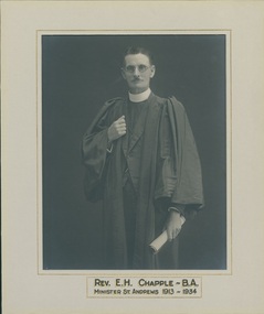
Photograph, Melba & Co, 1930
... The photograph has a grey which has a gold border and a black and gold script inscription. ...The photograph has a grey which has a gold border and a black and gold script inscription. ...Rev. E. H. Chapple (1866 - 1956) was educated at the University of Melbourne, and was ordained a Wesleyan minister. He was admitted Presbyterian in 1904. Matte, black and white 3/4 studio portrait of Rev. Edward Henry Chapple who is standing and looking directly at the camera. He is dressed in an academic gown over his clerical suit and collar and is holding a rolled document in his left had. The photograph has a grey which has a gold border and a black and gold script inscription. It is tipped onto brown card which has some pencil handwriting and an ink handwritten dedication at the bottom right.Front: "REV. E. H. CHAPPLE - B.A. MINISTER ST. ANDREWS 1913 - 1934" Back: "For Victor Taken 1930"rev e h chapple ba, st andrew's presbyterian church oakleigh, rev e h chapple ba presbyterian minister -
 Uniting Church Archives - Synod of Victoria
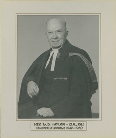
Photograph
... The photograph is on board and has a grey card mount with a gold border and inscription....The photograph is on board and has a grey card mount with a gold border and inscription. Photograph Photograph ...Rev. G. S. Taylor (1901 - 1959) attended university of Melbourne and was a chaplain to the forces in World War Two.Semigloss, black and white, 3/4 studio portrait of Rev. George Stewart Taylor whose is looking directly at the camera with his body is facing to the right of the camera. He is wearing his clerical collar and academic gown. The photograph is on board and has a grey card mount with a gold border and inscription."REV. G.S.TAYLOR - B.A.,B.D. MINISTER OF ST. ANDREWS 1942-1959"rev g s taylor presbyterian minister, world war two chaplain, st andrew's presbyterian church oakleigh -
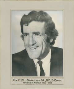 Uniting Church Archives - Synod of Victoria
Photograph, C. 1960
... The photograph is mounted on card and has a grey cardboard mount with a gold border and inscription....The photograph is mounted on card and has a grey cardboard mount with a gold border and inscription. Photograph Photograph ...Rev. MJL Griffiths (1926 - ) was Directory Stewardship and Promotion Vic in 1963 and Superintendent Australian Inland Mission in 1972 MBE.Semigloss, black and white, head and shoulders photograph of Rev. Maxwell John Lewis Griffiths who is wearing a collar and tie and looking to the right of the camera. The photograph is mounted on card and has a grey cardboard mount with a gold border and inscription."REV. M.J.L. GRIFFITHS - B.A., B.D., B.COMM. MINISTER ST ANDREWS 1960-1963"superintendent australian inland mission, rev maxwell john lewis griffiths presbyterian minsiter, st andrew's presbyterian church oakleigh -
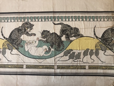 Villa Alba Museum
Decorative object - Nursery dado border wallpaper sample : Kittens and mice
... Above the similar lower border are sections imitating a wooden batons with the wood grain picked out in black on a yellow background. The colourway used in the sample includes outlines in black, grey, pale yellow and teal green....Above the similar lower border are sections imitating a wooden batons with the wood grain picked out in black on a yellow background. The colourway used in the sample includes outlines in black, grey, pale yellow and teal green. ...A wallpaper sample donated to the collection by Frances Alexandra (Frankie) Derham (1894–1987). Derham was an Australian artist and educator. A lecturer in art at the Melbourne Kindergarten Training College (1928-64) , she later taught at the Associated Teacher Training Institution (1949-61). Her commitment to `child art’ developed after 1935 when she accepted an invitation from Margaret Lyttle to teach at Preshil school.Frances Derham's collection of nearly ten thousand children’s drawings and paintings was acquired by the Australian National Gallery in 1976. Her interest in art for and by children is reflected in her donation to the Villa Alba Museum of an important and rare collection of early wallpapers designed for children's rooms. Section of a longer nursery wallpaper dado depicting kittens playing with a groups of mice watching. Under the solid and fine lines creating a border at the top is a series of tassels on a green background. Above the similar lower border are sections imitating a wooden batons with the wood grain picked out in black on a yellow background. The colourway used in the sample includes outlines in black, grey, pale yellow and teal green.decorative arts & design, wall coverings – history, wallpapers – history, interior decoration – history, wallpapers -- children's, frances derham, wallpapers -- dado borders -
Federation University Art Collection
Bookplate, 'Ex Libris John Gartner'
... Grey rectangular card with black ink border and letters of the alphabet surrounding the words 'Ex Libris John Gartner'...(http://www3.slv.vic.gov.au/latrobejournal/issue/latrobe-84/t1-g-t7.html) bookplate australian bookplate design award keith wingrove memorial trust printmaking Grey rectangular card with black ink border and letters of the alphabet surrounding the words 'Ex Libris John Gartner' 'Ex Libris John Gartner' Bookplate ...John Gartner was a fine printer and publisher, an author, a noted philatelist, and also collector of Australian banknotes and coins. He was born on 16 July 1914 and was largely self-educated, leaving school at fourteen for work following the death of his father. Gartner developed a strong interest in the history of typography and printing and was apprenticed at the Advocate where his father had been a linotype operator. Aged 17, Gartner bought a hand press and some fonts of type, and in 1937 acquired a platen press from which he set and printed his private press books, published under the imprint of The Hawthorn Press. Gartner had a strong collection of Australian bookplates. He also looked at the work of artists overseas and commissioned personal plates. He subsequently built an international collection with preference for artists who printed from wood. His initial searches were in Belgium and Holland.(http://www3.slv.vic.gov.au/latrobejournal/issue/latrobe-84/t1-g-t7.html) Grey rectangular card with black ink border and letters of the alphabet surrounding the words 'Ex Libris John Gartner'bookplate, australian bookplate design award, keith wingrove memorial trust, printmaking -
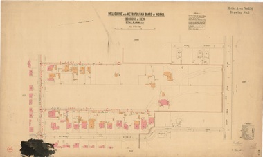 Kew Historical Society Inc
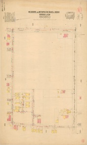
Plan, Melbourne & Metropolitan Board of Works : Borough of Kew : Detail Plan No.1591, 1905
... The hand-coloured sections of buildings on the plan were used to denote masonry or brick constructions (pink), weatherboard constructions (yellow), and public buildings (grey). That area of Kew bordered by Cotham Road, Park Hill Road, Ermington Lane (now Ermington Place), and Belmont Avenue contained some of the significant homes owned by Kew pioneers. ...The hand-coloured sections of buildings on the plan were used to denote masonry or brick constructions (pink), weatherboard constructions (yellow), and public buildings (grey). That area of Kew bordered by Cotham Road, Park Hill Road, Ermington Lane (now Ermington Place), and Belmont Avenue contained some of the significant homes owned by Kew pioneers. ...The Melbourne and Metropolitan Board of Works (MMBW) plans were produced from the 1890s to the 1950s. They were crucial to the design and development of Melbourne's sewerage and drainage system. The plans, at a scale of 40 feet to 1 inch (1:480), provide a detailed historical record of Melbourne streetscapes and environmental features. Each plan covers one or two street blocks (roughly six streets), showing details of buildings, including garden layouts and ownership boundaries, and features such as laneways, drains, bridges, parks, municipal boundaries and other prominent landmarks as they existed at the time each plan was produced. (Source: State Library of Victoria)This plan forms part of a large group of MMBW plans and maps that was donated to the Society by the Mr Poulter, City Engineer of the City of Kew in 1989. Within this collection, thirty-five hand-coloured plans, backed with linen, are of statewide significance as they include annotations that provide details of construction materials used in buildings in the first decade of the 20th century as well as additional information about land ownership and usage. The copies in the Public Record Office Victoria and the State Library of Victoria are monochrome versions which do not denote building materials so that the maps in this collection are invaluable and unique tools for researchers and heritage consultants. A number of the plans are not held in the collection of the State Library of Victoria so they have the additional attribute of rarity.Original survey plan, issued by the MMBW to a contractor with responsibility for constructing sewers in the area identified on the plan within the Borough of Kew. The plan was at some stage hand-coloured, possibly by the contractor, but more likely by officers working in the Engineering Department of the Borough and later Town, then City of Kew. The hand-coloured sections of buildings on the plan were used to denote masonry or brick constructions (pink), weatherboard constructions (yellow), and public buildings (grey). That area of Kew bordered by Cotham Road, Park Hill Road, Ermington Lane (now Ermington Place), and Belmont Avenue contained some of the significant homes owned by Kew pioneers. Chief among these was ‘Park Hill’ on an enormous lot facing Park Hill Road. The Jubilee History of 1910 noted, six years after this plan was drawn, that: ‘Park Hill Road, forming the southern boundary of the cemetery, takes its name from Park Hill, the residence of Mr. Thomas Judd, who has resided there since December, 1852.’ Other named houses on the plan include ‘Ferndale’ facing Cotham Road; ‘Ermington’ adjacent to Judd’s Park Hill, facing Park Hill Road; and ‘Gilden’ and ‘Mont Belmont’ facing Belmont Avenue. Mont Belmont was designed by the architectural firm of Reed, Henderson and Smart for William George Lilley in 1887 and was completed in 1888. Lilley was Mayor of Kew in 1887-88, a Justice of the Peace and a member of the first Board of Guardians of Kew’s St. Hilary’s Church of England.melbourne and metropolitan board of works, detail plans, survey plans - borough of kew, mmbw 1591, cartography -
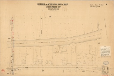 Kew Historical Society Inc
Plan, Melbourne & Metropolitan Board of Works : Borough of Kew : Detail Plan No.1302, 1910
... grey). The absence of buildings and or property in Kew facing the Yarra is the most notable feature of this plan. Walmer Street and its bridge stretched, then and now, from Studley Park Road to Victoria Street, Richmond. On the Richmond side of the Yarra, there was evidence in 1904 of industry (‘Wool shed’; Soap Works’) and entertainment (‘Skittle Alley’). In reality, another Plan (No.1303) shows Chinese Gardens bordering...grey). The absence of buildings and or property in Kew facing the Yarra is the most notable feature of this plan. Walmer Street and its bridge stretched, then and now, from Studley Park Road to Victoria Street, Richmond. On the Richmond side of the Yarra, there was evidence in 1904 of industry (‘Wool shed’; Soap Works’) and entertainment (‘Skittle Alley’). In reality, another Plan (No.1303) shows Chinese Gardens bordering ...The Melbourne and Metropolitan Board of Works (MMBW) plans were produced from the 1890s to the 1950s. They were crucial to the design and development of Melbourne's sewerage and drainage system. The plans, at a scale of 40 feet to 1 inch (1:480), provide a detailed historical record of Melbourne streetscapes and environmental features. Each plan covers one or two street blocks (roughly six streets), showing details of buildings, including garden layouts and ownership boundaries, and features such as laneways, drains, bridges, parks, municipal boundaries and other prominent landmarks as they existed at the time each plan was produced. (Source: State Library of Victoria)This plan forms part of a large group of MMBW plans and maps that was donated to the Society by the Mr Poulter, City Engineer of the City of Kew in 1989. Within this collection, thirty-five hand-coloured plans, backed with linen, are of statewide significance as they include annotations that provide details of construction materials used in buildings in the first decade of the 20th century as well as additional information about land ownership and usage. The copies in the Public Record Office Victoria and the State Library of Victoria are monochrome versions which do not denote building materials so that the maps in this collection are invaluable and unique tools for researchers and heritage consultants. A number of the plans are not held in the collection of the State Library of Victoria so they have the additional attribute of rarity.Original survey plan, issued by the MMBW to a contractor with responsibility for constructing sewers in the area identified on the plan within the Borough of Kew. The plan was at some stage hand-coloured, possibly by the contractor, but more likely by officers working in the Engineering Department of the Borough and later Town, then City of Kew. The hand-coloured sections of buildings on the plan were used to denote masonry or brick constructions (pink), weatherboard constructions (yellow), and public buildings (grey). The absence of buildings and or property in Kew facing the Yarra is the most notable feature of this plan. Walmer Street and its bridge stretched, then and now, from Studley Park Road to Victoria Street, Richmond. On the Richmond side of the Yarra, there was evidence in 1904 of industry (‘Wool shed’; Soap Works’) and entertainment (‘Skittle Alley’). In reality, another Plan (No.1303) shows Chinese Gardens bordering the Yarra on the Kew side and buildings in Young Street.melbourne and metropolitan board of works, detail plans, mmbw 1302, cartography -
 Kew Historical Society Inc
Plan, Melbourne & Metropolitan Board of Works : Borough of Kew : Detail Plan No.1561, 1905
... grey). MMBW Detail Plan 1561 outlines those residences in the area bordered by Burke Road, Loxton Street, Mount Street and Barkers Road that had been constructed by 1905 when the land was surveyed. ...grey). MMBW Detail Plan 1561 outlines those residences in the area bordered by Burke Road, Loxton Street, Mount Street and Barkers Road that had been constructed by 1905 when the land was surveyed. ...The Melbourne and Metropolitan Board of Works (MMBW) plans were produced from the 1890s to the 1950s. They were crucial to the design and development of Melbourne's sewerage and drainage system. The plans, at a scale of 40 feet to 1 inch (1:480), provide a detailed historical record of Melbourne streetscapes and environmental features. Each plan covers one or two street blocks (roughly six streets), showing details of buildings, including garden layouts and ownership boundaries, and features such as laneways, drains, bridges, parks, municipal boundaries and other prominent landmarks as they existed at the time each plan was produced. (Source: State Library of Victoria). This plan forms part of a large group of MMBW plans and maps that was donated to the Society by Mr Poulter, City Engineer of the City of Kew in 1989. Within this collection, thirty-five hand-coloured plans, backed with linen, are of statewide significance as they include annotations that provide details of construction materials used in buildings in the first decade of the 20th century as well as additional information about land ownership and usage. The copies in the Public Record Office Victoria and the State Library of Victoria are monochrome versions which do not denote building materials so that the maps in this collection are invaluable and unique tools for researchers and heritage consultants. A number of the plans are not held in the collection of the State Library of Victoria so they have the additional attribute of rarity.Original survey plan, issued by the MMBW to a contractor with responsibility for constructing sewers in the area identified on the plan within the Borough of Kew. The plan was at some stage hand-coloured, possibly by the contractor, but more likely by officers working in the Engineering Department of the Borough and later Town, then City of Kew. The hand-coloured sections of buildings on the plan were used to denote masonry or brick constructions (pink), weatherboard constructions (yellow), and public buildings (grey). MMBW Detail Plan 1561 outlines those residences in the area bordered by Burke Road, Loxton Street, Mount Street and Barkers Road that had been constructed by 1905 when the land was surveyed. At this time, the area nearest Burke Road had been subdivided and developed whereas the lands to the west were as yet undeveloped. The houses represented are not named on the Plan.melbourne and metropolitan board of works, detail plans, mmbw 1561, cartography -
 Kew Historical Society Inc
Plan, Melbourne & Metropolitan Board of Works : Borough of Kew : Detail Plan No.1564, 1905
... grey). In 1905, when Plan No.1564 was printed, that part of Kew bordered by Brougham Place (now Daniell Place), Mount Street, Sackville Street and Ross Street was already the location of a number of large mansions. ...grey). In 1905, when Plan No.1564 was printed, that part of Kew bordered by Brougham Place (now Daniell Place), Mount Street, Sackville Street and Ross Street was already the location of a number of large mansions. ...The Melbourne and Metropolitan Board of Works (MMBW) plans were produced from the 1890s to the 1950s. They were crucial to the design and development of Melbourne's sewerage and drainage system. The plans, at a scale of 40 feet to 1 inch (1:480), provide a detailed historical record of Melbourne streetscapes and environmental features. Each plan covers one or two street blocks (roughly six streets), showing details of buildings, including garden layouts and ownership boundaries, and features such as laneways, drains, bridges, parks, municipal boundaries and other prominent landmarks as they existed at the time each plan was produced. (Source: State Library of Victoria)This plan forms part of a large group of MMBW plans and maps that was donated to the Society by the Mr Poulter, City Engineer of the City of Kew in 1989. Within this collection, thirty-five hand-coloured plans, backed with linen, are of statewide significance as they include annotations that provide details of construction materials used in buildings in the first decade of the 20th century as well as additional information about land ownership and usage. The copies in the Public Record Office Victoria and the State Library of Victoria are monochrome versions which do not denote building materials so that the maps in this collection are invaluable and unique tools for researchers and heritage consultants. A number of the plans are not held in the collection of the State Library of Victoria so they have the additional attribute of rarity.Original survey plan, issued by the MMBW to a contractor with responsibility for constructing sewers in the area identified on the plan within the Borough of Kew. The plan was at some stage hand-coloured, possibly by the contractor, but more likely by officers working in the Engineering Department of the Borough and later Town, then City of Kew. The hand-coloured sections of buildings on the plan were used to denote masonry or brick constructions (pink), weatherboard constructions (yellow), and public buildings (grey). In 1905, when Plan No.1564 was printed, that part of Kew bordered by Brougham Place (now Daniell Place), Mount Street, Sackville Street and Ross Street was already the location of a number of large mansions. Here, subdivisions, at least at this stage, produced larger blocks than in Central Kew. Many of the houses on this plan are named: ‘Faybrook’, ‘Northumbria’, ‘Parkholm[e]’, ‘Dunboe’, ‘Katoomba’ and ‘Eschol’ fronting Sackville Street. Eschol was once the home of the manufacturer Robert Harrison, whose cordial factory in Spring and Argyle Streets Fitzroy are noted on the Victorian Heritage Register. ‘The Hawthorns’ on the corner of Brougham Place and Mount Street was the home of the medical practitioner Frank William Fay, who won the military cross and other honours for conspicuous gallantry and devotion to duty in World War 1.melbourne and metropolitan board of works, detail plans, mmbw 1564, cartography -
 Kew Historical Society Inc
Plan, Melbourne & Metropolitan Board of Works : Borough of Kew : Detail Plan No.1565, 1905
... grey). MMBW Plan No.1565 is an example of a plan where a number of streets have been created since the area was surveyed, or in other cases renamed. The plan shows those streets that were bordered...grey). MMBW Plan No.1565 is an example of a plan where a number of streets have been created since the area was surveyed, or in other cases renamed. The plan shows those streets that were bordered ...The Melbourne and Metropolitan Board of Works (MMBW) plans were produced from the 1890s to the 1950s. They were crucial to the design and development of Melbourne's sewerage and drainage system. The plans, at a scale of 40 feet to 1 inch (1:480), provide a detailed historical record of Melbourne streetscapes and environmental features. Each plan covers one or two street blocks (roughly six streets), showing details of buildings, including garden layouts and ownership boundaries, and features such as laneways, drains, bridges, parks, municipal boundaries and other prominent landmarks as they existed at the time each plan was produced. (Source: State Library of Victoria). This plan forms part of a large group of MMBW plans and maps that was donated to the Society by the Mr Poulter, City Engineer of the City of Kew in 1989. Within this collection, thirty-five hand-coloured plans, backed with linen, are of statewide significance as they include annotations that provide details of construction materials used in buildings in the first decade of the 20th century as well as additional information about land ownership and usage. The copies in the Public Record Office Victoria and the State Library of Victoria are monochrome versions which do not denote building materials so that the maps in this collection are invaluable and unique tools for researchers and heritage consultants. A number of the plans are not held in the collection of the State Library of Victoria so they have the additional attribute of rarity.Original survey plan, issued by the MMBW to a contractor with responsibility for constructing sewers in the area identified on the plan within the Borough of Kew. The plan was at some stage hand-coloured, possibly by the contractor, but more likely by officers working in the Engineering Department of the Borough and later Town, then City of Kew. The hand-coloured sections of buildings on the plan were used to denote masonry or brick constructions (pink), weatherboard constructions (yellow), and public buildings (grey). MMBW Plan No.1565 is an example of a plan where a number of streets have been created since the area was surveyed, or in other cases renamed. The plan shows those streets that were bordered by Ross Street, Mount Street, Sackville Street and Burke Road. Since 1905, Mawson Street has been created and Mont Albert Road renamed as Dean Street. Named houses on the plan include ‘Tyrol’, ‘Glengorse’, ‘Theodore Villa’, ‘Arncliffe’, ‘Ballynira’ and ‘Hazeldene’. The plan also shows a Wesleyan Church in Sackville Street. In 1883, the Church’s Sunday School celebrated its silver anniversary.melbourne and metropolitan board of works, detail plans, mmbw 1565, cartography -
 Kew Historical Society Inc
Plan, Melbourne & Metropolitan Board of Works : Borough of Kew : Detail Plan No.1571, 1904
... grey). This plan is part of a large and historically significant group of MMBW plans and maps that was donated to the Society by the Mr Poulter, City Engineer of the City of Kew in 1989. When the contracts were let for surveyors to identify and record the extant houses and landscapes within an area for the Board of Works, the contracts were let at separate times, hence the anomaly where two copies of Plan No.1571 exist in our collection. The first of these plans identifies the building materials used in houses bordering...grey). This plan is part of a large and historically significant group of MMBW plans and maps that was donated to the Society by the Mr Poulter, City Engineer of the City of Kew in 1989. When the contracts were let for surveyors to identify and record the extant houses and landscapes within an area for the Board of Works, the contracts were let at separate times, hence the anomaly where two copies of Plan No.1571 exist in our collection. The first of these plans identifies the building materials used in houses bordering ...The Melbourne and Metropolitan Board of Works (MMBW) plans were produced from the 1890s to the 1950s. They were crucial to the design and development of Melbourne's sewerage and drainage system. The plans, at a scale of 40 feet to 1 inch (1:480), provide a detailed historical record of Melbourne streetscapes and environmental features. Each plan covers one or two street blocks (roughly six streets), showing details of buildings, including garden layouts and ownership boundaries, and features such as laneways, drains, bridges, parks, municipal boundaries and other prominent landmarks as they existed at the time each plan was produced. (Source: State Library of Victoria)This plan forms part of a large group of MMBW plans and maps that was donated to the Society by the Mr Poulter, City Engineer of the City of Kew in 1989. Within this collection, thirty-five hand-coloured plans, backed with linen, are of statewide significance as they include annotations that provide details of construction materials used in buildings in the first decade of the 20th century as well as additional information about land ownership and usage. The copies in the Public Record Office Victoria and the State Library of Victoria are monochrome versions which do not denote building materials so that the maps in this collection are invaluable and unique tools for researchers and heritage consultants. A number of the plans are not held in the collection of the State Library of Victoria so they have the additional attribute of rarity.Digital copy of the original survey plan, issued by the MMBW to a contractor with responsibility for constructing sewers in the area identified on the plan within the Borough of Kew. The plan was at some stage hand-coloured, possibly by the contractor, but more likely by officers working in the Engineering Department of the Borough and later Town, then City of Kew. The hand-coloured sections of buildings on the plan were used to denote masonry or brick constructions (pink), weatherboard constructions (yellow), and public buildings (grey). This plan is part of a large and historically significant group of MMBW plans and maps that was donated to the Society by the Mr Poulter, City Engineer of the City of Kew in 1989. When the contracts were let for surveyors to identify and record the extant houses and landscapes within an area for the Board of Works, the contracts were let at separate times, hence the anomaly where two copies of Plan No.1571 exist in our collection. The first of these plans identifies the building materials used in houses bordering Fitzwilliam Street, Edgevale Road, May Street, Malin Street, Davis Street and Wellington Street. The cut off point for the survey was the south side of Wellington Street. By 1903 when the survey was undertaken many of the sites were already built on, particularly those facing Edgevale Road. The plan identifies the preponderance of weatherboard houses in the area. The other version of the plan identifies the buildings between Wellington Street and Cotham Road.melbourne and metropolitan board of works, detail plans, mmbw 1571, cartography -
 Kew Historical Society Inc
Plan, Melbourne & Metropolitan Board of Works : Borough of Kew : Detail Plan No.1291, 1905
... The hand-coloured sections of buildings on the plan were used to denote masonry or brick constructions (pink), weatherboard constructions (yellow), and public buildings (grey). A detail plan of part of Studley Park bordered by the major streets of Hodgson Street, Stevenson Street and Studley Park Road. ...The hand-coloured sections of buildings on the plan were used to denote masonry or brick constructions (pink), weatherboard constructions (yellow), and public buildings (grey). A detail plan of part of Studley Park bordered by the major streets of Hodgson Street, Stevenson Street and Studley Park Road. ...The Melbourne and Metropolitan Board of Works (MMBW) plans were produced from the 1890s to the 1950s. They were crucial to the design and development of Melbourne's sewerage and drainage system. The plans, at a scale of 40 feet to 1 inch (1:480), provide a detailed historical record of Melbourne streetscapes and environmental features. Each plan covers one or two street blocks (roughly six streets), showing details of buildings, including garden layouts and ownership boundaries, and features such as laneways, drains, bridges, parks, municipal boundaries and other prominent landmarks as they existed at the time each plan was produced. (Source: State Library of Victoria). This plan forms part of a large group of MMBW plans and maps that was donated to the Society by the Mr Poulter, City Engineer of the City of Kew in 1989. Within this collection, thirty-five hand-coloured plans, backed with linen, are of statewide significance as they include annotations that provide details of construction materials used in buildings in the first decade of the 20th century as well as additional information about land ownership and usage. The copies in the Public Record Office Victoria and the State Library of Victoria are monochrome versions which do not denote building materials so that the maps in this collection are invaluable and unique tools for researchers and heritage consultants. A number of the plans are not held in the collection of the State Library of Victoria so they have the additional attribute of rarity.Original survey plan, issued by the MMBW to a contractor with responsibility for constructing sewers in the area identified on the plan within the Borough of Kew. The plan was at some stage hand-coloured, possibly by the contractor, but more likely by officers working in the Engineering Department of the Borough and later Town, then City of Kew. The hand-coloured sections of buildings on the plan were used to denote masonry or brick constructions (pink), weatherboard constructions (yellow), and public buildings (grey). A detail plan of part of Studley Park bordered by the major streets of Hodgson Street, Stevenson Street and Studley Park Road. Included on the plan are a number of significant Studley Park mansions in existence at the beginning of the 20th century. The unnamed street shown in the middle of the plan is McEvoy Street. The most important house still extant is Campion House, formerly named Dalsraith [Dalswraith] and Glendalough, owned since the 1940s by the Society of Jesus. Campion House can be seen on the corner of Hodgson and Studley Park Road. Its stables at the rear of the block have now been incorporated into a contemporary residence. An interesting feature of the plan is the 1910 annotation by Ed Seitz, professional designing engineer. Is Seitz the contractor who modified the MMBW original?melbourne and metropolitan board of works, detail plans, mmbw 1291, cartography -
 Kew Historical Society Inc
Plan, Melbourne & Metropolitan Board of Works : Borough of Kew : Detail Plan No.1572, 1905
... grey). Plan No. 1572 represents the built environment bordered by Barkers Road, Wrixon Street, Edgevale Road and Fitzwilliam Street. ...grey). Plan No. 1572 represents the built environment bordered by Barkers Road, Wrixon Street, Edgevale Road and Fitzwilliam Street. ...The Melbourne and Metropolitan Board of Works (MMBW) plans were produced from the 1890s to the 1950s. They were crucial to the design and development of Melbourne's sewerage and drainage system. The plans, at a scale of 40 feet to 1 inch (1:480), provide a detailed historical record of Melbourne streetscapes and environmental features. Each plan covers one or two street blocks (roughly six streets), showing details of buildings, including garden layouts and ownership boundaries, and features such as laneways, drains, bridges, parks, municipal boundaries and other prominent landmarks as they existed at the time each plan was produced. (Source: State Library of Victoria)This plan forms part of a large group of MMBW plans and maps that was donated to the Society by the Mr Poulter, City Engineer of the City of Kew in 1989. Within this collection, thirty-five hand-coloured plans, backed with linen, are of statewide significance as they include annotations that provide details of construction materials used in buildings in the first decade of the 20th century as well as additional information about land ownership and usage. The copies in the Public Record Office Victoria and the State Library of Victoria are monochrome versions which do not denote building materials so that the maps in this collection are invaluable and unique tools for researchers and heritage consultants. A number of the plans are not held in the collection of the State Library of Victoria so they have the additional attribute of rarity.Original survey plan, issued by the MMBW to a contractor with responsibility for constructing sewers in the area identified on the plan within the Borough of Kew. The plan was at some stage hand-coloured, possibly by the contractor, but more likely by officers working in the Engineering Department of the Borough and later Town, then City of Kew. The hand-coloured sections of buildings on the plan were used to denote masonry or brick constructions (pink), weatherboard constructions (yellow), and public buildings (grey). Plan No. 1572 represents the built environment bordered by Barkers Road, Wrixon Street, Edgevale Road and Fitzwilliam Street. Other streets identified on the plan include Stansell Street. Plan 1572 shows that by 1903-05, there was only patchy development in this area of Kew, mainly on Edgevale Road and Fitzwilliam Street. Only two named houses are identified: the quaintly named ‘Tweed Cottage’, and ‘Mendip’. The earliest reference to Treed Cottage in Australian newspapers is to the death of Walter Thompson, aged 74 who was a resident there in 1885. His youngest daughter was to die there in 1908. Mendip to the north of Tweed Cottage was owned by Henry Thompson; he was to die in 1901; his wife in 1932. At this period of time, Malin Street and Clivedon Court did not extend to Barkers Road.melbourne and metropolitan board of works, detail plans, mmbw 1572, cartography -
 Ballarat Heritage Services
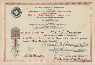
Certificate, Victorian Railways, Kinnane First Aid Certificate 1938, 1938
... White card with red border and red and grey print. Handwritten in ink....MBBS; V E Southwood; dated 1st October 1938 Victorian Railways White card with red border and red and grey print. Handwritten in ink. Kinnane First Aid Certificate 1938 Certificate Victorian Railways ...David Kinnane was the leader of a Victorian Railways First Aid team that won many state and interstate competitions. Other members of the team were: Geoffrey Storey and Joe Deveson. The Victorian Railways used to hold first aid competitions with groups of men competing in teams.White card with red border and red and grey print. Handwritten in ink.The St John Ambulance Association; Signatures - David J Kinnane; Rupert M Downes MD MS; John Heedman? MBBS; V E Southwood; dated 1st October 1938 Victorian Railwaysdavid kinnane, first aid, victorian railways, 1938, rupert m downes, rpert downes, v. e. southwood, st john ambulance association -
 Stawell Historical Society Inc
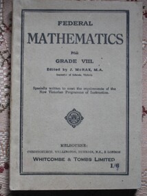
Book, Whitcombe & Tombs Limited, Federal Mathematics for Grade VIII edited by J McRae MA, 1910
... Grey card cover with black border and print diamond shaped design two thirds of the way down the cover.... & London Whitcombe & Tombs Limited 1/6 Inside: Theresa Euphemia Cumming Grey card cover with black border and print diamond shaped design two thirds of the way down the cover Federal Mathematics for Grade VIII edited by J McRae MA Book Whitcombe & Tombs Limited ...Mathematic book used in Victorian programme of instuction.Grey card cover with black border and print diamond shaped design two thirds of the way down the coverFederal Mathematics for Grade VIII. Edited by J. McRae, M.A. Inspector of Schools, Victoria Specially written to meet the requirements of the New Victorian Programme of Instruction. Melbourne: Christchurch: Wellington: Dunedin N.Z. & London Whitcombe & Tombs Limited 1/6 Inside: Theresa Euphemia Cummingstawell education -
 Stawell Historical Society Inc
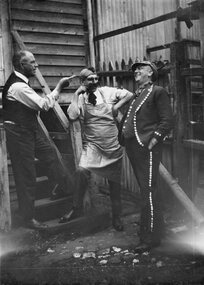
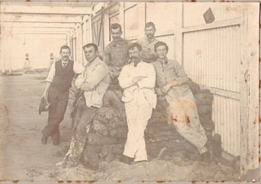
Photograph, Three men in Fancy dress -- behind W Carters Boot Shop in Main Street 1922
... Black and white photograph on a grey mount card with a lined border. The photo is a candid shot of 3 men. ...Black and white photograph on a grey mount card with a lined border. The photo is a candid shot of 3 men. ...Three men in Fancy dress 1922 taken behind W Carters Boot Shop Main Street. Probably `William Henry Carter on the left.Black and white photograph on a grey mount card with a lined border. The photo is a candid shot of 3 men. Two are in costume and looking jovial while the man standing on the step is more serious and pointing at one of the men. The timber stairs are leading to a timber building and behind the two in fancy dress is a picket fence 1922 W. Carter shop?stawell -
 National Wool Museum
Photograph
... Grey cardboard backing with black and white photo attached. Photo is attached inside a pale printed border. ...Grey cardboard backing with black and white photo attached. Photo is attached inside a pale printed border. ...From a family who had three generations that worked for Dennys Lascelles. Image depcits a group of men taking a break from painting. The room that was getting painted was a Dennys Lascelles store room, possible now the Mill Markets building or Deakin University.Grey cardboard backing with black and white photo attached. Photo is attached inside a pale printed border. Photo depicts 6 men seemingly taking a break from painting. There are two men seated on a pile of sheep skins, with four more men leaning against the skins in front of them. Four of the men smoke pipes. -
 National Wool Museum
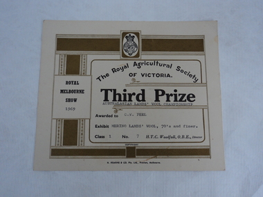
Certificate
... Cream coloured stiff paper certificate with dull gold/green borders, black text and grey typed personalised text to C.W. ...Cream coloured stiff paper certificate with dull gold/green borders, black text and grey typed personalised text to C.W. ...Certificate awarded to Mr. Charles Wilson Peel from the Royal Agricultural Society of Victoria, 1969. The certificate is for Third Prize. Mr Peel owned a superfine merino stud at Gnawarre named Callenondah. Cream coloured stiff paper certificate with dull gold/green borders, black text and grey typed personalised text to C.W. Peel for Merino lambs wool. Heading at top of certificate. -
 National Wool Museum
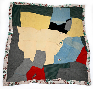
Textile - Wagga, Gwenyth Fletcher, c.1950s
... greys. The cardigan pieces include a pocket, button holes and one of the blanket patches has some of a blanket stitched border. ...greys. The cardigan pieces include a pocket, button holes and one of the blanket patches has some of a blanket stitched border. ...Gwenyth Fletcher (nee Thompson) was born in 1922 in Burwood. At six months of age her family moved to Blackheath where she lived until her marriage to John Fletcher. When Gwenyth was four years old, her grandfather was the mayor of Blackheath and as such, he had to welcome the Duke and Duchess of Kent to the town. Gwenyth presented the future King George VI and his wife Elizabeth with a posy of flowers as part of the welcoming ceremony. John and Gwenyth were married in 1951 and in 1952 they moved to Canowindra. John was working for the Presbyterian Church and they needed an assistant sheep worker at Ernabella (now Pukatja), a remote First Nations community, in the far North West of South Australia and he had worked there prior to his marriage. The work involved sheep, vehicles and general handy man work, and trips to Finke (railway 200 miles east). After marriage John was again asked to work at Ernabella. He and Gwenyth left for Ernabella in 1953 and returned in November. They then bought a property in Canowindra and the family stayed for four years before returning to Ernabella. Two children were born whilst they were in Canowindra. The family stayed for eight years at Ernabella from 1958 to April 1966. During the time at Ernabella and Fregon, three more children were born. In May 1966, the family returned to the farm in Canowindra. John and Gwenyth retired from the farm in 1985 and moved to South Canowindra. The Wagga was probably made during the time at Ernabella from children's knits and other leftovers. John had to camp out from the home a lot in order to muster sheep and the desert nights are cold. There is evidence (ties) that Gwenyth made the wagga into a swag-like product that John could easily carry. There were few resources available to her in the remote region, so she used what she had. Gwenyth was known for her reuse of everything – she never threw anything out. Everything was repurposed or recycled. Gwenyth Fletcher was my mother-in-law. Because I was interested in quilts/quilting and patchwork she gave me the blanket instead of throwing it out. She gave it to me during the 1990s. - Donor, November 2025Wagga blanket with base made from two different beige/light khaki blankets. One of the blankets is lightly striped. The top is made up of random, non-geometrical pieces of cardigans and jumpers and other blankets that are machine stitched to the bottom blankets. The cardigans are different colours - light blue, red, navy, yellow and light yellow and are knitted with different patterns. The top blanket pieces are different greys. The cardigan pieces include a pocket, button holes and one of the blanket patches has some of a blanket stitched border. The top also has some green striped material patches. The whole blanket/quilt is bordered by a wide brown patterned material. Some of this material is also used as smaller patches on holes in the cardigans. There are also some hand stitched repairs.wagga, remote community, gwenyth fletcher, king george vi, canowindra, ernabella, pukatja, swag, blanket, sheep, rural life -
 Whitehorse Historical Society Inc.
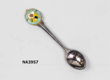
Memorabilia - Spoons
... Crest surrounded by aqua border inset with red flowers on white background. The other half has yellow background depicting bowling balls. In grey...Crest surrounded by aqua border inset with red flowers on white background. The other half has yellow background depicting bowling balls. In grey ...Mitcham Bowling Club spoons. Crest surrounded by aqua border inset with red flowers on white background. The other half has yellow background depicting bowling balls. In grey plastic coverMitcham Bowling Club/Paramount EPNS (A1)recreations, sports, domestic items, cutlery -
 Whitehorse Historical Society Inc.
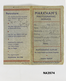
Document - Photographic Folder
... Grey light cardboard, red markings for borders with dark blue printing...Grey light cardboard, red markings for borders with dark blue printing Document Photographic Folder ...Mitcham Post Office began in a shop in Whitehorse Road next but one from Elizabeth Street and Whitehorse Road. They moved to a shop on the corner of Whitehorse Road and Station Street with Mrs. Markham as Post Mistress. She had an assortment of items for sale in the shop. They daughter May married and lived with her parents and had quite a large family. Mary set up a photographic service, developing films and taking portraits of people and taking sets of photographs of the Mitcham area and selling photographic supplies for Kodak and Hesma. Information supplied by donor, Frances WarrenPart of a photographic folder from Markham's Photographic Service. Grey light cardboard, red markings for borders with dark blue printingMarkham Photographic Servicephotography, processing equipment -
 Federation University Art Collection
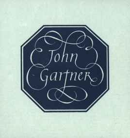
Bookplate, 'John Gartner'
... The title is depicted in white on a grey blue background within an eight sided border...(http://www3.slv.vic.gov.au/latrobejournal/issue/latrobe-84/t1-g-t7.html) bookplate printmaking australian bookplate design award keith wingrove memorial trust The title is depicted in white on a grey blue background within an eight sided border 'John Gartner' Bookplate ...John Gartner was a fine printer and publisher, an author, a noted philatelist, and also collector of Australian banknotes and coins. He was born on 16 July 1914 and was largely self-educated, leaving school at fourteen for work following the death of his father. Gartner developed a strong interest in the history of typography and printing and was apprenticed at the Advocate where his father had been a linotype operator. Aged 17, Gartner bought a hand press and some fonts of type, and in 1937 acquired a platen press from which he set and printed his private press books, published under the imprint of The Hawthorn Press. Gartner had a strong collection of Australian bookplates. He also looked at the work of artists overseas and commissioned personal plates. He subsequently built an international collection with preference for artists who printed from wood. His initial searches were in Belgium and Holland.(http://www3.slv.vic.gov.au/latrobejournal/issue/latrobe-84/t1-g-t7.html) The title is depicted in white on a grey blue background within an eight sided borderbookplate, printmaking, australian bookplate design award, keith wingrove memorial trust