Showing 213 items
matching murrays bridge
-
 Wodonga & District Historical Society Inc
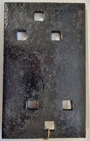
Functional object - Rail fish plate from Cudgewa Line, 1930 - 1960s
Cudgewa Line -The Cudgewa railway line opened in stages between 1889 and 1921. The first section from Wodonga to Huon opened on 10 September 1889. It was extended to Bolga on 18 July 1890, Tallangatta on 24 July 1891, Shelley on 13 June 1916 (the highest station in Victoria), Beetomba on 10 April 1919 and Cudgewa on 5 May 1921. The line had 1 in 30 grades and trestle bridges that have been heritage listed. In 1919, the line was used to carry materials for the construction of Hume Weir, and three years later a spur line connecting Ebden to the weir was opened. In the 1960s, Cudgewa became the railhead of materials for the Snowy Mountains Scheme. The last passenger service from Wodonga to Tallangatta ran on 30 September 1961. The turntable and passenger platform at Cudgewa were abolished in 1976. This fish plate came from the rails of the Cudgewa Line at Gordon Roy's hut which was situated behind Perry's Stump Hotel outside Wodonga. The hut was used as an office with the points lever outside to switch trucks to different tracks on the Bandiana and Cudgewa lines.This item is significant as it was part of the railway line to Cudgewa which played an important role in North east Victoria carrying freight during the construction of the Hume Weir and the Snowy Mountains Scheme.A section of flat plate. These plates were used in pairs to connect the ends of adjacent rails in railway track. victorian railways, cudgewa rail line, railway components -
 Wodonga & District Historical Society Inc
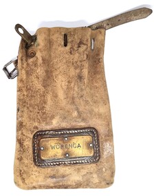
Functional object - Leather pouch and stamps - Cudgewa Railway Line
Cudgewa Line -The Cudgewa railway line opened in stages between 1889 and 1921. The first section from Wodonga to Huon opened on 10 September 1889. It was extended to Bolga on 18 July 1890, Tallangatta on 24 July 1891 and then to Shelley on 13 June 1916. Shelley was the highest station in Victoria. It extended further on to Beetomba on 10 April 1919 and finally reached Cudgewa on 5 May 1921. The line had 1 in 30 grades and trestle bridges that have been heritage listed. In 1919, the line was used to carry materials for the construction of Hume Weir, and three years later a spur line connecting Ebden to the weir was opened. In the 1960s, Cudgewa became the railhead of materials for the Snowy Mountains Scheme. The last passenger service from Wodonga to Tallangatta ran on 30 September 1961. The turntable and passenger platform at Cudgewa were abolished in 1976. These stamps were used by Joh Murray who for many years worked with Victorian Railways based at Wodonga.A leather pouch with belt and lock. It bears a metal name tag inscribed with name of railway station. The pouch contains 3 station stamps, a date stamp and 2 carriage keys.On pouch WODONGA On stamps: BONEGILLA 1470/ EBDEN 1471/ BANDOLIER 1473cudgewa rail line, victorian railways, closed victorian railways, railway stamps -
 Wodonga & District Historical Society Inc
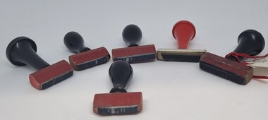
Functional object - Railway Station stamps Cudgewa Line
Cudgewa Line -The Cudgewa railway line opened in stages between 1889 and 1921. The first section from Wodonga to Huon opened on 10 September 1889. It was extended to Bolga on 18 July 1890, Tallangatta on 24 July 1891 and then to Shelley on 13 June 1916. Shelley was the highest station in Victoria. It extended further on to Beetomba on 10 April 1919 and finally reached Cudgewa on 5 May 1921. The line had 1 in 30 grades and trestle bridges that have been heritage listed. In 1919, the line was used to carry materials for the construction of Hume Weir, and three years later a spur line connecting Ebden to the weir was opened. In the 1960s, Cudgewa became the railhead of materials for the Snowy Mountains Scheme. The last passenger service from Wodonga to Tallangatta ran on 30 September 1961. The turntable and passenger platform at Cudgewa were abolished in 1976.6 Rubber and wood stamps used in the stations along the Cudgewa Line. The stamps were primarily used to acknowledge receipt of small freight items carried on the Cudgewa LineOn individual stamps: 1. TALLANGATTA 1476 2. BULLIOH 1477 3. BEETOOMBA 1484 4. KOETONG 1480 5. SHELLEY 1482 6. CORRYONG 1487cudgewa rail line, victorian railways, closed victorian railways -
 Wodonga & District Historical Society Inc
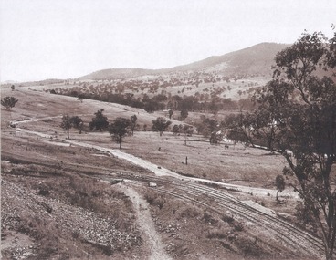
Album - Hume Reservoir Australia Album - Driving first row of piles for coffer dam across the river, December 1925
This set of photos is from a leather bound album bearing the inscription "HUME RESERVOIR AUSTRALIA" plus 'The Rt. Hon. L. C. M. S. Amery, P. C., M .P.' all inscribed in gold. It was presented to The Rt. Hon. L. C. M. S. Amery, P. C., M. P, Secretary of State for Dominion Affairs on the occasion of his visit to the Hume Reservoir on 2nd November 1927. This album is of local and national significance as it documents the planning and development of the Hume Reservoir up to 1927. It was the largest water reservoir in the British Empire. The album records the pioneering engineering work that went into its construction.DEPARTMENT OF PUBLIC WORKS, N.S.W. RIVER MURRAY WATERS SCHEME. HUME RESERVOIR. 19. Driving first row of piles for coffer dam across the river. New South Wales. December 1925. Cofferdams are temporary structures used where construction is being carried out in areas submerged in water. They are most commonly used to facilitate the construction or repair of dams, piers and bridges. To divert the river, a Coffer Dam was built across the old bed above and below the Dam site and tying into the end of the concrete wall built inside the levee bank. This completely surrounded the remainder of the site of the Dam and south wing wall, including an area of 12½ acres. hume reservoir australia, river murray waters scheme, hume reservoir construction -
 Wodonga & District Historical Society Inc
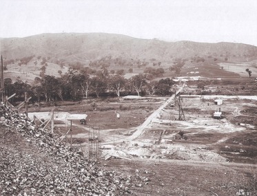
Album - Hume Reservoir Australia Album - Section of completed coffer dam, January 1927
This set of photos is from a leather bound album bearing the inscription "HUME RESERVOIR AUSTRALIA" plus 'The Rt. Hon. L. C. M. S. Amery, P. C., M .P.' all inscribed in gold. It was presented to The Rt. Hon. L. C. M. S. Amery, P. C., M. P, Secretary of State for Dominion Affairs on the occasion of his visit to the Hume Reservoir on 2nd November 1927. This album is of local and national significance as it documents the planning and development of the Hume Reservoir up to 1927. It was the largest water reservoir in the British Empire. The album records the pioneering engineering work that went into its construction.DEPARTMENT OF PUBLIC WORKS, N.S.W. RIVER MURRAY WATERS SCHEME. HUME RESERVOIR. 20. Section of completed coffer dam with river diverted over the concrete foundations of dam that were placed during the first stage of operations. New South Wales. January 1927. Cofferdams are temporary structures used where construction is being carried out in areas submerged in water. They are most commonly used to facilitate the construction or repair of dams, piers and bridges. To divert the river, a Coffer Dam was built across the old bed above and below the Dam site and tying into the end of the concrete wall built inside the levee bank. This completely surrounded the remainder of the site of the Dam and south wing wall, including an area of 12½ acres. hume reservoir australia, river murray waters scheme, hume reservoir construction -
 Wodonga & District Historical Society Inc
Album - Hume Reservoir Australia Album - Excavations for foundations inside coffer dam, January 1927
This set of photos is from a leather bound album bearing the inscription "HUME RESERVOIR AUSTRALIA" plus 'The Rt. Hon. L. C. M. S. Amery, P. C., M .P.' all inscribed in gold. It was presented to The Rt. Hon. L. C. M. S. Amery, P. C., M. P, Secretary of State for Dominion Affairs on the occasion of his visit to the Hume Reservoir on 2nd November 1927. This album is of local and national significance as it documents the planning and development of the Hume Reservoir up to 1927. It was the largest water reservoir in the British Empire. The album records the pioneering engineering work that went into its construction.DEPARTMENT OF PUBLIC WORKS, N.S.W. RIVER MURRAY WATERS SCHEME. HUME RESERVOIR. 21. Excavations for foundations inside coffer dam. New South Wales. January 1927. Cofferdams are temporary structures used where construction is being carried out in areas submerged in water. They are most commonly used to facilitate the construction or repair of dams, piers and bridges. To divert the river, a Coffer Dam was built across the old bed above and below the Dam site and tying into the end of the concrete wall built inside the levee bank. This completely surrounded the remainder of the site of the Dam and south wing wall, including an area of 12½ acres. hume reservoir australia, river murray waters scheme, hume reservoir construction, coffer dam -
 Wodonga & District Historical Society Inc
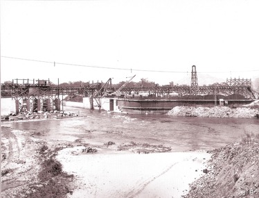
Album - Hume Reservoir Australia Album - Valley of the Murray to be crossed by the Bethanga Bridge 1927
This set of photos is from a leather bound album bearing the inscription "HUME RESERVOIR AUSTRALIA" plus 'The Rt. Hon. L. C. M. S. Amery, P. C., M .P.' all inscribed in gold. It was presented to The Rt. Hon. L. C. M. S. Amery, P. C., M. P, Secretary of State for Dominion Affairs on the occasion of his visit to the Hume Reservoir on 2nd November 1927. This album is of local and national significance as it documents the planning and development of the Hume Reservoir up to 1927. It was the largest water reservoir in the British Empire. The album records the pioneering engineering work that went into its construction.DEPARTMENT OF PUBLIC WORKS, N.S.W. RIVER MURRAY WATERS SCHEME. HUME RESERVOIR. 36. Valley of the Murray to be crossed by the Bethanga Bridge described in the next photograph. (WHS 00731) This view shows the marshalling sidings for trucks below the Quarry, New South Wales, and the branch line to the site of the bridge.hume reservoir australia, river murray waters scheme, hume reservoir construction -
 Wodonga & District Historical Society Inc
Album - Hume Reservoir Australia Album - Bethanga Bridge Site, August 1927
This set of photos is from a leather bound album bearing the inscription "HUME RESERVOIR AUSTRALIA" plus 'The Rt. Hon. L. C. M. S. Amery, P. C., M .P.' all inscribed in gold. It was presented to The Rt. Hon. L. C. M. S. Amery, P. C., M. P, Secretary of State for Dominion Affairs on the occasion of his visit to the Hume Reservoir on 2nd November 1927. This album is of local and national significance as it documents the planning and development of the Hume Reservoir up to 1927. It was the largest water reservoir in the British Empire. The album records the pioneering engineering work that went into its construction.DEPARTMENT OF PUBLIC WORKS, N.S.W. RIVER MURRAY WATERS SCHEME. HUME RESERVOIR. 37. Bethanga Bridge Site. A bridge is being built to cross the Reservoir to serve a large area of country which will be cut off from its natural outlets by the submergence of existing bridges when the Reservoir is in being. The site of the bridge is nearly a mile up the Murray from the Hume Reservoir Quarry. Its length will be approximately half a mile. There will be nine spans of 269 feet with steel truss girders resting on concrete pillars. Some of the pillars are founded on rock while others will rest on nests of reinforced concrete piles. The foundations and concrete piers are in the hands of the Victorian Constructing Authority and the superstructure in those of the New South Wales Authority. August 1927.hume reservoir australia, river murray waters scheme, hume reservoir construction -
 Wodonga & District Historical Society Inc
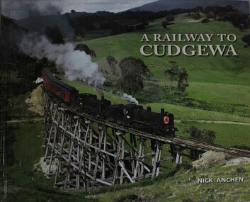
Book - A Railway to Cudgewa, Nick Anchen, 2013
The spectacular mountain railway from Wodonga to Cudgewa in north eastern Victoria was one of Australia's truly fascinating branch lines, and the most challenging to operate on the Victorian Railways. It was a railway of scenic splendour, famous for its towering wooden bridges, notoriously steep grades, Hereford cattle and K class steam locomotives. This lavishly illustrated publication includes over 100 colour and B&W photographs, and tells the story of the railway through the memories of Cudgewa railway enginemen, station masters, bridge gangers,non-fictionThe spectacular mountain railway from Wodonga to Cudgewa in north eastern Victoria was one of Australia's truly fascinating branch lines, and the most challenging to operate on the Victorian Railways. It was a railway of scenic splendour, famous for its towering wooden bridges, notoriously steep grades, Hereford cattle and K class steam locomotives. This lavishly illustrated publication includes over 100 colour and B&W photographs, and tells the story of the railway through the memories of Cudgewa railway enginemen, station masters, bridge gangers,railroads victoria, railways cudgewa, railways wodonga, railways high country -
 Wodonga & District Historical Society Inc
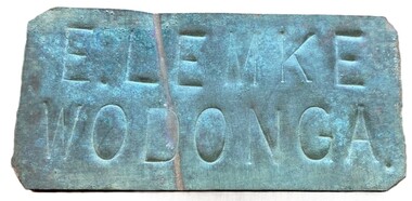
Sign - Name Plate E. Lemke Wodonga
The dairy farm of Eric Lemke and family was located on the Wodonga flats on the Murray River flood plain, west of the Union Bridge. The property was named "Waterford". They ran a large dairy herd (250 cows) and ran five milk carts to Albury to service their customers. The family bought a second property at Wodonga West, on Felltimber Creek, where herds could be rested before calving, and also as an emergency location for milking during times of flood, which sometimes lasted for several weeks at a time. At other times when the cows finished their lactation period at "Waterford" they would be walked to the Lemke property at Wodonga West, for a rest before calving. When the calves were drafted it was a matter of gathering the cows and calves and walking them back home which was an all day job. During the Depression Mr. Lemke took milk to the out-of-work men who slept under the bridges on the causeway and Mrs Lemke would make bread for them. The men would often work on the farm without wages in return for the Lemke's kindness. The Lemke Family are ranked amongst the top early settlers of the district for their perseverance during the hardships of the early days and during the Great Depression. Lemke Road on Gateway Island, Wodonga is named in their honour.This item has local significance because it came from a prominent Wodonga family business.A small metal tag used to label dairy cans on the property of Eric Lemke.E. LEMKE WODONGAe. lemke wodonga, lemke family, wodonga dairy industry, ernie lemke -
 Wodonga & District Historical Society Inc
Album - Ringer's River by Des Martin - Plate 35 - Moves towards Federation
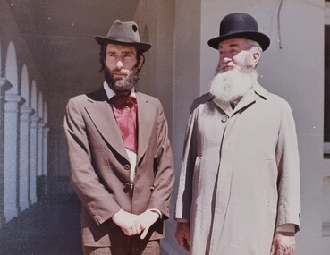
With Federation all but a fact Alfred Deakin is again in the Overton area but his meeting has been cancelled. While Montieth is getting some stores he and MacLough observe the drama on the bridge from the nearby Post Office verandah. Coming on top of the deaths of the O'Haras these scenes appal Deakin. In reply to MacLough he says that Federation will do away with the border, and bring free trade between the states of the new Australian Commonwealth. This will permit O'Day to come home as a free man. MacLough queries the fine and Deakin says that it must be paid, but he will have it reduced to £200. On hearing this MacLough declares he will pay the fine himself, and give O'Day a half share partnership in Gooloora as well.The album and images are significant because they document literature written by a prominent member of the Wodonga community. The presentation of this precis was supported by several significant district families and individuals.Ringer's River Album Coloured photo Plate 35des martin, many a mile, ringer's river, northeast victoria stories -
 Wodonga & District Historical Society Inc
Album - Ringer's River by Des Martin - Plate 33 - Escaping the Police
... on the bridge over the Murray. Cornering him on the bridge he says... the Murray. Cornering him on the bridge he says it will give him ...The bodies of mother and son are driven side by side to burial while the shops shut down and all Overton turns out for the funeral. Ellen's elder son Con O'Hara, and Sean O'Day ride as outriders to the hearses. Sgt. Baker and his men arrive at the church, the Sgt. approaches Con, declares that no police action will be taken before the town re-opens, and asks if he can provide an escort for the cortege. The funeral over O'Day tarries till after the shops have opened and Sgt. Baker sets a trap for him on the bridge over the Murray. Cornering him on the bridge he says it will give him great pleasure to personally escort him all the way to the police station. "All the way Sergeant?" asks O'Day. "Then come on!" With which he jumps his horse over the rail of the bridge. D.J. Martin on Pampas Air.The album and images are significant because they document literature written by a prominent member of the Wodonga community. The presentation of this precis was supported by several significant district families and individuals.Ringer's River Album Coloured photo Plate 33des martin, many a mile, ringer's river, northeast victoria stories -
 Wodonga & District Historical Society Inc
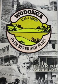
Book - Wodonga Over River and Plain, Alan J. Dunlop, 1976
... Migrant Experience, 132 Bonegilla Road Bonegilla the-murray ...A great local history of the Wodonga area. Starts with discussion of the Aboriginal inhabitants of the region and early contacts with European explorers and settlers. Explains the establishing of a customs post with its twin city Albury on the other side of the Murray River. The town grew subsequent to the opening of the first bridge across the Murray in 1860. Originally named Wodonga, its name was changed to Belvoir then later back to Wodonga.non-fictionA great local history of the Wodonga area. Starts with discussion of the Aboriginal inhabitants of the region and early contacts with European explorers and settlers. Explains the establishing of a customs post with its twin city Albury on the other side of the Murray River. The town grew subsequent to the opening of the first bridge across the Murray in 1860. Originally named Wodonga, its name was changed to Belvoir then later back to Wodonga.victoria. wodonga, settlers wodonga, indigenous australians wodonga -
 Wodonga & District Historical Society Inc
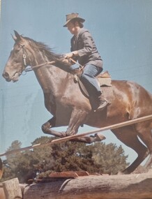
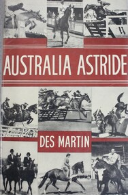
Book - Australia Astride, Desmond Martin, 1959
A detailed study of horsemanship in Australia incorporating the general teachings of the bushman and those of the Show and Race rider. This valuable study of riding bridges the gap in literature between the working and sporting worlds of the horse. Different riding styles and all items of essential equipment and their maintenance are discussed against a background of extensive experience and practical knowledge.non-fictionA detailed study of horsemanship in Australia incorporating the general teachings of the bushman and those of the Show and Race rider. This valuable study of riding bridges the gap in literature between the working and sporting worlds of the horse. Different riding styles and all items of essential equipment and their maintenance are discussed against a background of extensive experience and practical knowledge.horsemanship, role of horses australia -
 Wodonga & District Historical Society Inc
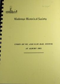
Book - Union of Vic. and N.S.W. Rail System at Albury 1883
... railway bridge across the Murray River was opened. A grand ...The final linking of the railway systems of Victoria and NSW at Albury-Wodonga was finally achieved in June 1883 when a temporary railway bridge across the Murray River was opened. A grand celebration was held in Albury to mark the occasion. This book details the significance of the railway and the celebrations of 1883.non-fictionThe final linking of the railway systems of Victoria and NSW at Albury-Wodonga was finally achieved in June 1883 when a temporary railway bridge across the Murray River was opened. A grand celebration was held in Albury to mark the occasion. This book details the significance of the railway and the celebrations of 1883.railways australia, railway albury wodonga, history railways -
 Bendigo Historical Society Inc.
Administrative record - Spring Gully Gold Mining Co. Fryerstown, Minute Book1903 - 1915, 1924 - 1929
The Spring Gully Gold Mining property consists of Gold Mining Lease No. 2986, Castlemaine, of about 21 acres situated on the Emu Reef, in Spring Gully Fryers. There are two shafts, distant about 300 feet from each other. From one of them large quantities of gold were obtained in former years by previous companies. ( Prospectus of the Spring Gully Mining CompanyMaroon hard cover book, brown leather binding on spine and corners, three hundred and eighty pages. Written on spine of book in gold leaf : 'Minute Book'. Handwritten minute entries from 14th September 1903 to 30th August 1915. Affixed to first page, newspaper clipping from the 'Herald' 13/9/05, with information about the Spring Gully Mine Fryerstown. Page eighty-one has two quotes affixed from 'The Yarraville Chlorination and Ore Reduction Works' High Street Yarraville, July 1905, for works associated with pyrites and blanket sand. Page nine, a handwritten letter affixed to minutes, applying for a block of land 250 feet north of main shaft. Signed by J.S. Potter, H. Hancock, G Murray and T. Tumney. 1.Page one hundred and one: three quotes from 'Edwards' Metallurgical Works' Specimen Hill, Bendigo for pyrites and blanket sand. 2.Page one hundred and fifty five: handwritten letter (copy) from A. Schonfelder re shaft work on the mine and mention of tributors 3. Affixed to inside cover: letter from the 'United Shire of Mount Alexander' April 15th. 1907, regarding the reconstruction of the Vaughan bridge over the Loddon River. 'the benefit that the mines in your district derive from the bridge being open for wood waggons and this being the main traffic and this being the principal cause of the bridges present condition'. 4. Prospectus of the Spring Gully Mining Company, Spring Gull, Fryerstown, two page folded document enclosed inside back cover of book. Prospectus incomplete. (10746.93a) 5. Carbon copy of letter to D.E. Williams Esq, Castlemaine from GlenAthol, Casewick Road, London, January 25th, 1907 regarding two gentlemen who were 'called upon to carry the 'Spring Gullys' through - Mr. H. 'is making a determined effort to bring the matter to a successful issue' Letter signed by George Allan. (10746.93b. 6. Carbon copy of letter from E. Williams, London re proposed new company to acquire the properties of Spring G.M. Coy, Spring Gully G.M. Coy. No. 1, Sth Spring Gully G.M. Coy, Sth Spring Gully G.M. Coy Extended (10746.93c) 7. Handwritten letter to the Chairman and Directors of the Spring Gully G.M. Co. re the appointment of 'Mr. Samuel Morse Battery Manager at once, or accept my resignation as Mining Manager, for we can't agree any longer' Signed by A. Schonfelder. 8. Notice of extraordinary meeting of shareholders in Spring Gully Gold Mining Company No Liability, 22nd November 1906 at Beehive Chambers, Bendigo. Signed W.G. Blackham (Blackham & Garvin) Manager of the Company. (10746.93e) The Minute Book is part of the Margaret Roberts Collection of mining documents.bendigo, margaret roberts, , goldmining, castlemaine, spring gully gold mine, fryertown -
 Wodonga & District Historical Society Inc
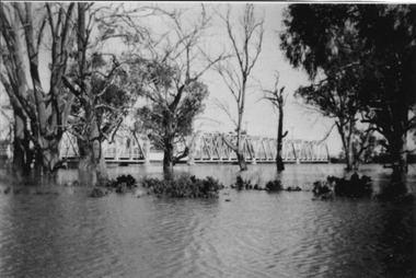
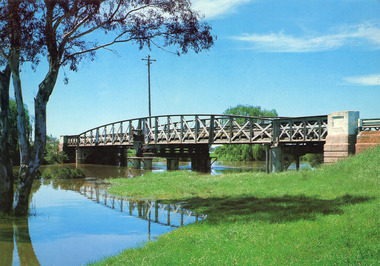
Photograph - Bethanga Bridge
The Bethanga Bridge was built between 1927 and 1930 as a joint venture between Victoria and New South Wales and was a key element of the River Murray Waters Agreement. It consists of nine spans of 82 metres long. Each span is supported between double reinforced concrete pylons and a riveted steel camel back Pratt truss. The overall span of the bridge is a length of 752 metres. It was completed in 1929 at a cost of £194,000. The road deck was initially constructed from timber but was replaced in 1961 with a concrete waffle slab deck 7.7metres wide. In 1961 the bridge deck and truss structure were raised 300 millimetres to allow for the enlargement of the lake. The bridge was designed in NSW by road engineer Percy Alan and the trusses were built by the Charles Ruwolt Pty. Ltd. Charles Ruwolt Pty. Ltd. was originally established by Charles Ruwolt as a foundry at Wangaratta in 1902 and transferred its operations to Richmond, Melbourne in 1914. By 1938 it had become one of the biggest engineering companies in Australia. After Charles Ruwolt’s death in 1946, Vickers Ltd. acquired the company and in 1948 the firm became known as Vickers Ruwolt Pty. Ltd. Because of the Bethanga Bridge’s unique location, over the waters of a dam with the border running down the centre of the body of water, the Bethanga Bridge is the only built structure shared by both Victoria and New South Wales. As the border of New South Wales aligns with the southern bank of the Murray River all of the other bridges along its length are deemed to be in New South Wales. The Bethanga Bridge is listed on both the New South Wales State Heritage Register and the Victorian Heritage Database. In 2015 the Bethanga Bridge was nominated for a heritage award by the Institution of Engineering Australia.These images are significant because they document the construction of a bridge which links Victoria and New South Wales and has been recognised for its historical, technical and engineering significance.A collection of photos documenting the construction of the Bethanga Bridge which links the States of Victoria and New South Wales as part of the construction of the Hume Dam .bethanga bridge, hume dam constuction, charles ruwolt, percy allan engineer -
 Forests Commission Retired Personnel Association (FCRPA)
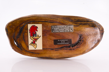
Presentation plaque from the "Woodpeckers"
... timber bridges along the Murray River, the Snake Island Jetty... timber bridges along the Murray River, the Snake Island Jetty ...In the post-war era from 1947 to the mid-1980s, the Forests Commission sponsored Australia's only military sawmilling unit, the 91 Forestry Squadron. It was a special reserve unit of the Royal Australian Engineers (RAE). Established and commanded by Commission forester and WW2 veteran, Major Ben Benallack, the "Woodpeckers" as they were known comprised a small pool of specialised soldiers capable of rapid mobilisation in the event of need. Several other Victorian departments such as the State Electricity Commission (SEC) did the same thing who supported a construction squadron based at Newborough in the Latrobe Valley. The scheme created a very active and capable part-time military group that completed many worthy projects across the State. In addition to their military training, the Woodpeckers operated bush sawmills, built timber bridges along the Murray River, the Snake Island Jetty, forest roads and performed various demolition tasks.Presentation plaque from the "Woodpeckers" Mounted on polished wooden burl forests commission victoria (fcv) -
 Clunes Museum
Book, NSW ROADS AND TRAFFIC AUTHORITY, ORAL HISTORY PROGRAM - A VITAL LINK THE EUSTON TO ROBINVALE MURRAY RIVER CROSSING, 2007
AN ORAL HISTORY PROJECT ABOUT A VITAL LINK BETWEEN EUSTON AND ROBINVALESPIRAL BOUND WITH IMAGES OF AN OLD IRON BRIDGE AND A NEW CONCRETE BRIDGE ON THE FRONT COVER DETAILING AN ORAL HISTORY PROJECT WITHIN THE TITLE OF THE BOOK. 81 PAGES AND AN ORAL HISTORY CD IS ATTACHED TO THE BACK PAGEnon-fictionAN ORAL HISTORY PROJECT ABOUT A VITAL LINK BETWEEN EUSTON AND ROBINVALEeuston to robinvale, river crossing, oral history -
Merbein District Historical Society
Slide, Abbotsford Bridge, NSW side, unknown
... Abbotsford Bridge Murray River Abbotsford Bridge, NSW side Slide ...abbotsford bridge, murray river -
Merbein District Historical Society
Journal - Quarterly, Merbein Historian - Journal MDHS - No 8 (ex. The Newsletter) (2 copies), Jun.2002
foster house, winifred christina fletcher, john shillington, lord ranfurly, lady ranfurly, lady constance ranfurly, merbein west, cecil bennett, augusta henriette schmidt, augusta henriette bennett, winifred christina bennett, picton's bridge, jutland street - merbein, aurora packing pty ltd merbein branch, dried fruit, industry, reg. glanville, chrissie glanville, ned glanville, merbein baths, merbein swimming pool, sport, band rotunda, park kenny, w.j. and w.h. hedley, j.p. power, c.h. martin, b. gaggin, j.r. kemp, j.c. wishart, j. mcneilly, h.w. horace, d. radcliffe, w.h. gilkes, mr jamieson, g.c. mckenzie, j. stevens, j.j. rogers, f.c. kane, e.j. kenny, lodge 410 merbein, w.j. kirwin, j.r. kemp, l.v. treadwell, g.m. hudson, a.t. punton, h.a. jenner, hall crosbie, mr higginbotham, gwen godkin, miff johnson, tom mccarthy, murray lloyd, olwen walters, e. smythe, p. hillman, j. murphy, v. braidie, d. nagle, k. rogers, t. hickey, h. higginbotham, m. rogers, l. leonard, t. jnr. mccarthy, l. mccarthy, mr hibberd, e. cook, t.v. burns, v.f. burns, w. marshal, s. mccarthy, m. power, marnie dorman -
Merbein District Historical Society
Journal - Quarterly, Merbein Historian - Journal MDHS - No 13 (ex. The Newsletter) (2 copies) Sep. 2003, 2003
150th anniversary of murray river shipping, lady augusta, charles sturt, abbotsford bridge 75th anniversary, witchetty tribe, harry traeger, jack lapthorne, f.c. kane, len keens, merbein west state school, mary jamieson, alexander "sandy" jamieson, bowring's staff -
 Merbein District Historical Society
Photograph, Abbotsford Bridge, 1937
... Abbotsford Bridge Murray River Abbotsford Bridge Photograph ...abbotsford bridge, murray river -
 Merbein District Historical Society
Photograph, Abbotsford Bridge, 1927
... Abbotsford Bridge Murray River Abbotsford Bridge Photograph ...abbotsford bridge, murray river -
 Merbein District Historical Society
Photograph, Abbotsford Bridge & Punt, 1927
... Abbotsford Bridge Murray River Abbotsford Bridge & Punt Photograph ...abbotsford bridge, murray river -
 Merbein District Historical Society
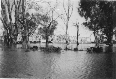
Photograph, Murray River flood Abbotsford, 1956
... Abbotsford Bridge Murray River Floods Murray River flood Abbotsford ...abbotsford bridge, murray river, floods -
 Merbein District Historical Society
Photograph, Murray River flood Abbotsford Bridge, 1956
... Murray River flood Abbotsford Bridge... Abbotsford Bridge Murray River Floods Murray River flood Abbotsford ...abbotsford bridge, murray river, floods -
Lakes Entrance Historical Society
Book, Colwell, Max, The Big Rivers' Murray, Darling, Murrumbidgee, 1978
The Murray-Darling basin river system - called the rivers of life. Victoria, New South Wales and South Australia. 32,000 Kms. along the system.waterways, catchments, natural disasters, bridges, commerce, land settlement -
 Eltham District Historical Society Inc
Photograph - Digital Photograph, Marguerite Marshall, Eltham Retirement Centre (Judge Book Memorial Village), Diamond Street, Eltham, 23 October 2006
Thousands of elderly people at this centre have contributed much. Published: Nillumbik Now and Then / Marguerite Marshall 2008; photographs Alan King with Marguerite Marshall.; p161 Thousands of elderly people, who have contributed much to Nillumbik and beyond, have made their home in the treed Eltham Retirement Centre. The centre, which opened in 1956, has housed the disadvantaged in particular, through good times and hard, including floods, fire and even burglaries. As part of the Melbourne Citymission, a non-denominational Christian organisation that cares for people living with disadvantage, the centre was built to celebrate 100 years of the Melbourne Citymission’s work since 1854. Standing on a former poultry farm called Willandra (Still Waters), the centre includes independent units, hostel, nursing home accommodation and a Day Therapy Centre, which is available for non-residents as well. Despite being metres from the busy Main Road and railway station, the centre provides a quiet oasis on 6.8 hectares bordered by the Diamond Creek to the west, and the railway line to the east. The centre was originally named Judge Book Memorial Village after Judge Clifford Book, Deacon of the Collins Street Baptist Church. Book was also President of the Baptist Union of Victoria and Grand Master of the Masonic Lodge. He was so respected that, at his death, several Pentridge prisoners asked to attend his funeral. In 1993 the centre’s name was changed to clarify that it was part of the Melbourne Citymission. However Judge Book’s name continues in the Judge Book Memorial Garden, opened in 2006. The Diamond Creek has flooded the centre several times, however rarely causing serious damage. Volunteer Alan Field recalls a flood in 1974 when the resident manager Reverend Norman Pearce and his wife, were rescued by boat from their home with their budgerigar. On February 3, 2005, when the creek almost flooded Metzner Hall, 35 ambulances evacuated residents to nearby nursing homes, hostels and local homes. Residents were also evacuated during the 1965 bush fire, but fortunately a change of wind direction saved the centre. Residents have also endured several burglaries. Despite much rebuilding and modernisation over the years, traces of the original farmhouse remain in the administration areas. In 1991 the Willandra Hostel was built and in 2001 the Eltham Lodge Nursing Home with each room having a garden view. Several buildings are named after people who have given special service to the centre including the Norman Pearce Day Hospital after general manager and pastor Rev Pearce. Metzner Hall was named after the Metzner family who had been active in the auxiliary since it began and had donated generously to the Recreation Hall fund.3 A bridge was named after Sister Lila Murray who had worked at the village for 42 years in various capacities including as relieving manager. Field remembers Sister Murray as ‘the Mother Teresa and soul of what the village aspired to, with love and care’. Since 1957 the Eltham Auxiliary, later called the Residents’ Association, has worked to improve the residents’ quality of life by volunteering and raising funds. An outstanding volunteer, Field, who was drawn to the centre in 1971 with his wife Chris, has held positions on the early Eltham boards, auxiliaries and Residents’ Association. Much of his work has been supporting people with no family and those of limited means. He says he and his wife look at their work as having shared ‘our lives with amazing people’. The wealth of experience and wisdom in the Retirement Village has benefited many people, including local school children. Residents have acted as proxy grand-parents at local schools, by assisting small learning groups or telling their life stories. Conversely, students from local schools have visited to perform, or to assist in programs like craft activities. Resident Val Bell, whose mother Rose Bullock lived at the centre before her, sums up the centre’s most important attribute for her: ‘The Christian care. They could not be more caring’.This collection of almost 130 photos about places and people within the Shire of Nillumbik, an urban and rural municipality in Melbourne's north, contributes to an understanding of the history of the Shire. Published in 2008 immediately prior to the Black Saturday bushfires of February 7, 2009, it documents sites that were impacted, and in some cases destroyed by the fires. It includes photographs taken especially for the publication, creating a unique time capsule representing the Shire in the early 21st century. It remains the most recent comprehenesive publication devoted to the Shire's history connecting local residents to the past. nillumbik now and then (marshall-king) collection, diamond street, eltham, eltham retirement centre, eltham retirement village, judge book memorial village -
 Lakes Entrance Historical Society
Photograph - Bridges, Murray Views Gympie, 1980
... Photograph Bridges Murray Views Gympie ...Photo printed on Jumbo card by Murray Views, Gympie QLDColour photograph showing swing bridge on Latrobe River, shows north facing side of bridge, willows on opposite bank on site of Latrobe River wharf, river running very high, two red gum trees in water on left. Longford Victoriabridges, waterways