Showing 11214 items matching "planning "
-
 Flagstaff Hill Maritime Museum and Village
Document - Ship Model Plans, Loch Ard, October 1977
These two framed model ship plans are from more than 650 produced for the LOCH ARD Centenary (1878-1978) Commemoration Committee. These plans were originally researched, designed and distributed in 1977 to assist entrants in the Committee’s Ship Model Competition. The competition was arranged as a means of creating public interest and awareness for the 100th anniversary of the tragic LOCH ARD shipwreck on Victoria’s south west coast in 1878. The main subject specified for modelling was “The Loch Ard ― Iron Wool Clipper 1873”. “The plans were drawn by Mr P Webb to the order of the Committee through Mr P Williams, organizer of the competition. The details were based on all available information which resulted in considerable historical research…and received favourable comment from model makers because of their attention to detail…In excess of 650 sets of plans were sold before entries closed…Many plans were probably purchased by collectors and interested persons for historical reference. An illustrated historical story sheet…was prepared and enclosed with the plans…” (‘Loch Ard Shipwreck Centenary 1878-1978 Report’, November 1978). An example of the attention to historical detail delivered on the plans is the inclusion of the following useful information about the original vessel: “Tonnage….1,693 G.R.T., 1,624 N.R.T. Builders….Charles Connell & Co., Ltd., Scotstoun, 1873. Owners….General Shipping Co., Glasgow, (Aitken Lilburn & Co., Ltd.)”. The quality of research and drafting makes these framed copies of considerable interpretive value to related items from the LOCH ARD shipwreck on display at Flagstaff Hill. They were originally mass produced but are now out of print. Flagstaff Hill retains other (unframed) copies in storage. The plans, in conjunction with the scale Ship Model of the LOCH ARD also on display, are of interpretive significance to Flagstaff Hill Maritime Village. The plans provide historical and technological context to artefacts from the shipwreck, increasing understanding and appreciation of those objects. Flagstaff Hill’s collection of artefacts from LOCH ARD is significant for being one of the largest collections of artefacts from this shipwreck in Victoria. It is significant for its association with the shipwreck, which is on the Victorian Heritage Register (VHR S417). The collection is significant because of the relationship between the objects, as together they have a high potential to interpret the story of the LOCH ARD. The LOCH ARD collection is archaeologically significant as the remains of a large international passenger and cargo ship. The LOCH ARD collection is historically significant for representing aspects of Victoria’s shipping history and its potential to interpret sub-theme 1.5 of Victoria’s Framework of Historical Themes (living with natural processes). The collection is also historically significant for its association with the LOCH ARD, which was one of the worst and best known shipwrecks in Victoria’s history. Two framed model ship plans of the LOCH ARD. These are detailed and researched plans from the original vessel, drawn to scale and printed on good quality paper, and framed behind glass to be hung on display. One slightly smaller plan “Lines, Decks and Details” portrays the hull lines as a body plan (straight on at the bow), a sheer plan (full side view), and a half breadth plan (a top-down view of deck to keel), as well as two top-down views of the upper decks and main deck with fittings and details of specific fixtures. One slightly larger “Sail and Rigging Plan” presents a side on, above deck view of masts and shrouds and a front on, above deck view showing “Elevation of Mainmast Looking Aft”. Each plan bears the draftsman’s initials and date of completion (“P.A.W. 10/77”). The larger plan also includes a boxed label attributing the project to the “LOCH ARD CENTENARY Commemoration Committee Ship Model Competition.”Smaller plan: heading “LOCH ARD: LINES, DECKS and DETAILS”; initials “P.A.W. 10/77”. Larger plan: heading “LOCH ARD: SAIL and RIGGING PLAN”; initials “P.A.W. 10/77”; label “LOCH ARD CENTENARY Commemorative Committee Ship Model Competition”. flagstaff hill, warrnambool, shipwrecked coast, flagstaff hill maritime museum, maritime museum, shipwreck coast, flagstaff hill maritime village, great ocean road, loch line, loch ard, captain gibbs, eva carmichael, tom pearce, glenample station, mutton bird island, loch ard gorge, ship model plans, loch ard model plans, sailing ship, loch ard centenary -
 University of Melbourne, Burnley Campus Archives
Photograph, Ministry for Planning and Environment April 1966. Photographic Archive Project, Museum of Victoria, Display of Early Victorian Gardens, 1996
... Ministry for Planning and Environment April 1966 ...display, early victorian gardens, garden design, linton district, geelong, stockyard hill, amherst -
 Kew Historical Society Inc
Book, Plan of General Development, Melbourne : Report of the Metropolitan Town Planning Commission
... Metropolitan Town Planning Commission ...The 1929 report of the Metropolitan Town Planning Commission covering Melbourne and its suburbs. Includes photographs and 15 folding maps (some in rear pocket) This was a planning scheme to prevent 'misuse' of land and protect property values. It highlighted traffic congestion, the distribution of recreational open space and haphazard intermingling of land uses. The plan identified a number of problems, such as the congestion at St Kilda Junction, that were not addressed until decades later. The plan also recognised the value of Melbourne's waterways as an open space network.xii, 308 p., [25] leaves of plates (24 folded) : ill., maps (some col.), ports., plans ; 34 cm. CONTENTS Part 1 Surveys and studies Part II Communications Part III The execution of improvement schemes - a programme of urgent works Part IV Zoning Part V Public Recreation Part VI Public Utilities Part VII Housing and Land Subdivision Part VIII Civic Art and Amenities Part IX Miscellaneous Part X Legislation Part XI Conclusionnon-fictionThe 1929 report of the Metropolitan Town Planning Commission covering Melbourne and its suburbs. Includes photographs and 15 folding maps (some in rear pocket) This was a planning scheme to prevent 'misuse' of land and protect property values. It highlighted traffic congestion, the distribution of recreational open space and haphazard intermingling of land uses. The plan identified a number of problems, such as the congestion at St Kilda Junction, that were not addressed until decades later. The plan also recognised the value of Melbourne's waterways as an open space network.city planning -- victoria. -- maps, city planning -- victoria -- melbourne, city planning -- victoria, civic improvement -- victoria -- melbourne, melbourne -- (vic.), cartography -
 Melbourne Tram Museum
Document - Tender Document, Melbourne & Metropolitan Tramways Board (MMTB), "Engineering Department - Planning Branch - Modal Interchange Investigations 1974 - 1975", 1975
... "Engineering Department - Planning Branch - Modal ...Comb bound (brown plastic) report, manila card covers, approx. 10 pages, plus yellow sheets plus four folded drawings titled "Engineering Department - Planning Branch - Modal Interchange Investigations 1974 - 1975". Study looks at five possible modal interchanges: 1. - Box Hill Railway Station 2. - High St / Harp Road, Kew 3. - St Kilda Road / Park St / Domain Road 4 - Swanston St and Flinders St station 5 - Blackburn Railway station.In red felt pen on top right hand corner "(118)". Has stamp "Discarded from PTC Library 22 Oct. 1989" on front cover and the first sheet.trams, tramways, mmtb, tram stops, railways, domain junction, swanston st, flinders st station, blackburn -
 National Wool Museum
Plan - Machinery Layouts, J Dyson & Sons Pty Ltd
Two machinery plan layouts for Mimosa Wool & Textiles Pty Ltd in Hobson's Road, Kensington.1617.1 Rectangular blue paper with white lined plan drawing and white text 1617.2 Rectangular blue paper with white lined plan drawing1617.1 Front: Final Plan / PLAN OF MACHINERY LAYOUT / MIMOSA WOOL & TEXTILES PTY LTD / HOBSON'S ROAD KENSINGTON / BY MESSRS J DYSON & SONS / SOUTH GEELONG / Scale 3/32" - 1.0"factory, machinery, wool, textiles, mill, kensington, south geelong, plans, drawings, blueprint, layout, mimosa, j. dyson and sons pty ltd -
 National Wool Museum
Plan, Plan of Drainage for Dennys Lascelles Ltd
Plan for alterations to the drainage and plumbing of the Dennys Lascelles wool store (current building and demolished building).Drainage plan for Dennys Lascelles building, c.1920s. Detail of drainage plan for Dennys Lascelles building, c.1920s.PLAN OF DRAINAGE / for / Dennys Lascelles Lim. / (Messrs Laird & Buchan, Agents) / MUNICIPALITY: CITY OF GEELONGwool stores, dennys, lascelles limited laird and buchan, plans -
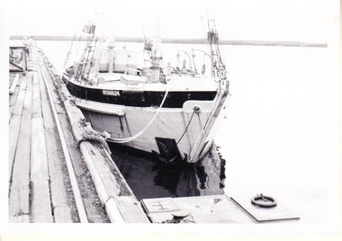 Flagstaff Hill Maritime Museum and Village
Photograph - Vessels, Sail and Steam Ships, c. 1972-1975
... Flagstaff Hill Historic Park Planning Board ...Andy Clapham owned and operated a boat yard on the Maribyrnong River in Footscray, Victoria. The river runs into Port Phillip Bay (sometimes known as Hobson’s bay) at Williamstown, an area with a history of trades associated with the shipping and construction industry. Andy Clapham’s photographs include those of the Reginald M and one of Polly Woodside, another vessel restored and used as a maritime exhibition. Andy Clapham’s letter of 1972 was posted in a and envelope with an early Australian decimal currency stamp showing the profile portrait of Queen Elizabeth II, and valued at 7 cent. Andy offered invaluable advice to the Flagstaff Hill Historic Park Planning Board regarding the purchase a vessel suitable for use as an exhibit once Flagstaff Hill was opened. The Planning Board was set up by the Warrnambool Chamber of Commerce and approved by the City Council and State Government. Flagstaff Hill was investigating vessels in Adelaide and Tasmania as well as Melbourne. Andy looked at several vessels in 1972-1973. He also serviced the Reginald M among other vessels belonging to Captain Julian Dyson of Yarra Ferries, who had casually offered the vessel to Flagstaff Hill as a price that was unattainable at the time. Flagstaff Hill later requested photographs of the hull to discern the dimensions and also the condition of the timbers as well as wanting advice on its seafaring capability. In 1972 the Flagstaff Hill Historic Park Planning Board – Chairman J. (John) S. Lindsay (1972-1980), Secretary J. (James) Mark – wrote a letter of appreciation to Mr A. (Andy) Clapham of 3 Charles Street Footscray ... “Dear Mr. Clapham, The Board has asked me to write to you to express our appreciation for the assistance you have offered us through our Chairman John Lindsay. The information you have already given us has been invaluable, in that is shows us that we have not been setting out to do something that is impossible. We look forward to receiving further information from you as it becomes available and we appreciate that you must be busy enough without our problems. Members of our Board hope to call and see you on a trip to Melbourne in the near future. The Board is optimistic about the future of Flagstaff Hill as a Maritime Museum and look forward to you visiting Warrnambool to examine what we believe will be an ideal site. Yours faithfully, James Mark.” ABOUT the vessel “Reginald M” The vessel “Reginald M” was a two-masted, timber coastal vessel built by John Henry Murch in Birkenhead, Port of Adelaide, South Australia. It was named after Reginald Murch. (It was occasionally referred to as the Reginald “Emm”). Its construction took approximately 6 months using many materials and fittings from salvage yards. It is believed that the keep was hewn from two telegraph poles! Reginald M was launched at Largs Bay in 1922. Reginald M was approximately 30 metres long and was fore-to-aft ketch rigged with an ‘auxiliary’ motor to support any loss of sail power. The Reginald M was built to service the coastal ports of South Australia to Port Victoria on the York Peninsular, Spencer Gulf. It freighted cargo from port to port cheaply and efficiently. It had a very shallow draft and a flat bottom, enabling it to come close to shore and sit high and dry at low tide, or to be beached on the sand. It could easily skim over reefs due to its flat bottom. Wagons could be loaded and unloaded directly from the side of the vessel. Over the years her cargo included guano, barley, wool, horses, cattle, timber, explosives, potatoes, shell grit and gypsum. The Murch brothers from Port Adelaide were owners of the Reginald M and Richard Murch as the Captain. On April 9, 1931, Reginald M weathered a large storm in St. Vincents Gulf, SA, suffering much damage; the mast snapped and the crew laboured for four hours to free it up by severing the mast and rigging. The crew patched it up and slowly returned to Port Adelaide with only a portion of the insured cargo being damaged. The crew members at that time were owner Mr John Henry Murch of Wells Street Largs Bay, Skipper Mr R Murch – John’s brother, Murray – son of Captain Murch and Seaman John Smith. At some stage it seems that the Reginald M was used as a Customs vessel “H.M.C. No. 3, Pt Adelaide” as shown in a photograph in Flagstaff Hill’s collection. In 1969 Reginald M’s last freight trip left Marion Bay, carrying grain, wool and explosives. In late 1970 it was sold to the Mount Lyall Mining and Railway Clompany and used as a barge to carry explosives. In 1972 The Navy League of Strahan, Tasmania, purchased the vessel for use by the Strahan Sea Cadet Unit at Macquarie Harbour; it was renamed “T.S. Macquarie”. (This plan did not come to pass.) In 1974 Mr Andrew Rennie of East Brighton, Melbourne, brought Reginald M for shipping purposes, He sailed it from Strahan to Melbourne, planning to use it for pleasure sailing. The Reginald M was later sold at auction to Captain Julian Dyson, owner of Yarra Passenger Ferries in Melbourne. Later in 1975 funds became available to Flagstaff Hill Maritime Village to purchase the Reginald M. It was then restored and used as an exhibit here for many hears. Flagstaff Hill’s collection also includes various objects related to the Reginald M: - Photographs of Reginald M over the years in various aspects of its use - a life buoy with the inscription of “Pt. Adelaide” - helm section that was removed and replaced during restoration - a bullet found in pieces of timber during the 1979 restoration ABOUT THE POLLY WOODSIDE On the bow in the Polly Woodside's photograph is the word "RONA". the Polly Woodside was built at Belfast in 1885. In 1904 the vessel was sold to A.H. Turnbull of New Zealand and renamed "RONA". The letter and photographs are significant for their association with the Reginald M, an Australian built coastal trader now on the Australian Register of Historic Vessels (number HV000562). The letter and photographs are also significant as part of both the history of Flagstaff Hill and the history of the vessel “Reginald M” that has been on display in the lake for many years. Objects retained from this boat are included in Flagstaff Hill’s collection of maritime history.Packet with photographs and negatives in a KODAK envelope. The photographs are of two sail and steam vessels; twelve (12) black and white photographs of the 'Reginald M', and one (1) colour photograph of the Polly Woodside, plus six (6) negative strips. Included int he packet is a letter in stamped and postmarked envelope addressed to Mr A Clapham of Footscray. The envelope postmarked 9 Dec 1972, with the Warrnambool postcode 3280, A 7c Australian postage stamp in attached to the envelope. They are associated with Flagstaff Hill’s acquisition of the vessel “Reginald M”. Envelope "9 DEC 1972 / 3280" Postage stamp "7c" "Australia" Inscriptions on one Reginald M;; "REGINALD M" and "Pt ADELAIDE H.M.C. No. 3" Inscriptions of the Polly Woodside; "RONA / MSC" "MHI / NO. 1" Ball point ink, reverse of photograph "POLLY WOODSIDE"flagstaff hill, warrnambool, shipwrecked coast, flagstaff hill maritime museum, maritime museum, shipwreck coast, flagstaff hill maritime village, great ocean road, vessel reginald m, reginald emm, t. s. macquarie, h.m.c. no. 3, pt adelaide, australian register of historic vessels (number hv000562), boat building trade, jack murch, john henry murch, birkenhead, port adelaide sa, largs bay sa, coastal trader south australia, 1920 ketch reginald m, marion bay produce, mount lyall mining and railway company, navy league of strahan, tasmania, melbourne ferry company, flagstaff hill historic park planning board, john lindsay, james mark, andy clapham of footscray, andy clapham boat builder, kodak photograph packet envelope, kodak super-size prints, kodak australia pty ltd, australian postage stamp 1972 - 7c -
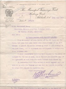 Melbourne Tram Museum
Administrative record - Correspondence, The Municipal Tramways Trust of Adelaide, "Woods Gilbert Rail Planning Machine", 1915 and 1916
... "Woods Gilbert Rail Planning Machine" ...Carbon copy of Correspondence dated 15 June 1916 between The Municipal Tramways Trust of Adelaide and the Secretary of the Prahran and Malvern Tramways Trust regarding the "Woods Gilbert Rail Planning Machine". Consists of - Carbon copy (on quarto paper) from W. Goodman, on MTT letterhead to W. Strangward of the PMTT regarding assistance for the machine (and two carbon copies of the same letter on plain paper) and a carbon copy of the agreement between the Woods Gilbert Rail Planer Co. Limited of Victoria and the MTT giving details of Royalties, use and letters Patent. Gives the names of the parties who signed the agreement - dated 1915.trams, tramways, pmtt, letters, mtt, trackwork, rail wear, rail planning, machines -
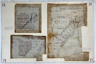 Greensborough Historical Society
Poster - Planning Document, City of Heidelberg, Subdivision Plan # 35 - Parish of Keelbundoora, Crown Portion 16, Watsonia, 1918
Subdivision Plan # 35 Parish of Keelbundoora, Crown Portion 16: 3 plans on one sheet. Plan 1: Lambourn Road, Boger Street, Kenmare Street, Greensborough Road, Devonshire Road, Watsonia (stamped "Superseded"). Plan 2: an update of plan 1. Plan 3: Also Lambourn Road, Boger Street, Kenmare Street, dated 1918, Shire of Heidelberg.An example of hard copy subdivision plans from the Greensborough area. Mainly from the Shire of Diamond Valley era (1964-1994).3 Plans (single sided) mounted on heavy card. Stamped and handwritten Council permissions, dates and other details. Plan 1 has been stamped in red "SUPERCEDED" and overwritten by hand "Cancelled".subdivision plans, city of heidelberg, greensborough, main street greensborough, shire of heidelberg, watsonia -
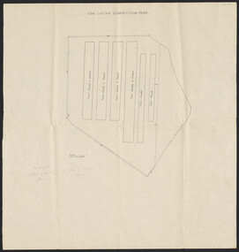 University of Melbourne, Burnley Campus Archives
Plan, Egg Laying Competition Pens, c. 1957
Plan of layout of the fowl sheds and coops.Handwritten on plan ,"on original 1. plan of existing fence. 2. plan of proposed fence." sheds, coops, egg laying, competitions -
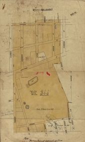 Federation University Historical Collection
Plan, Ballaarat No 5722, 28/11/1903
Part of the block shaded yellow on the plan contains Phoenix P-12 School Senior CampusPlan of Ballarat with leae area No 5722 coloured yellow. Plan of the streets around Hertford Street, ballarat. The yellow depicts the area leased (No 5722 Ballarat)mining lease 5722 ballarat, ballarat, hertford street, cromwell street, alexandra street, alfred street, verdon street, clarkson street, spencer street, franklin street, hill street, grant street, albion street, rowlands street, edwards street north, mining, cgt, plans, phoenix p-12 school senior campus -
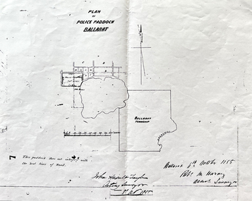 Friends of Ballarat Botanical Gardens History Group
Work on paper - Site of the Ballarat Botanical Gardens, Plan of Police Paddock, Ballarat, 6th October 1855, October, 1855
Plan of Police Paddock, Ballarat, 6th October 1855.In 1855, the Police Paddock occupied the land of the present Ballarat Botanical Gardens.One large white sheet of paper photocopied and folded with a black margin at either end, and the plan and printing in longhand.The Plan is signed and dated by the Acting Surveyor and Assistant Surveyor, October, 1855.john garner collection, garner, dr, police, paddock, plan, map, 1855, ballarat botanical gardens, ballarat, gardens, wendouree, swamp. -
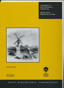 Ballarat Tramway Museum
Magazine, Institute of Engineers Australia, "Transactions of Multi-Disciplinary Engineering - Special Issue Engineering Heritage - Vol GE23 1999", "Conservation Planning and a 1905 Electric Tramcar", Apr. 2000
... Planning and a 1905 Electric Tramcar" ...140 page paper cover book/magazine published by the Institute of Engineers Australia - Transactions of Multi-Disciplinary Engineering - Special Issue Engineering Heritage - Vol GE23 1999. Contains on pages 107 - 114 an item presented at the Ballarat Conference on Engineering Heritage during March 1999. Paper written by Warren Doubleday, titled "Conservation Planning and a 1905 Electric Tramcar". Fourteen papers presented at the conference contained within the volume. Paper has photographs of No. 12, recovery, work and other Ballarat photos. Printed on glossy white paper with two colour front cover - brown and black. Also contained is a letter from Ray Martin, the conference organiser, forwarding a copy of the transactions. Actually published early April 2000. Note all photographs were transmitted by email, about Dec. 1999. See image i3 for a pdf of the actual published document. Scanned as well is a paper on the Lydiard St Level crossing gates.trams, tramways, esco, institute of engineers, conservation planning, papers, level crossings, lydiard st north, railway station -
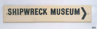 Flagstaff Hill Maritime Museum and Village
Sign - Shipwreck Museum sign, Flagstaff Hill Historic Park Planning Board, Shipwreck Museum, ca. 1975
... Flagstaff Hill Historic Park Planning Board ...This sign is painted on both sides. It was attached to the bluestone wall on the western wing of the Lighthouse Keeper's Quarters, the Assistant Keeper's Quarters, at Flagstaff Hill Maritime Museum and Village for almost 50 years. The Complex was opened to the public on December 11, 1975, and officially opened by Victorian Premier Sir Rupert Hamer on July 8th, 1977. The sign's reverse side reads "Loch Ard Peacock & Museum". The three rooms had displays behind glass showing various ships' fittings, cargo and personal belongings recovered from significant shipwrecks along the southwest coast of Victoria. There was also a display of information about the mysterious Mahogany Ship or Ancient Wreck. The shipwreck artefacts were recovered by local divers in the 1960s and early 1970s. Also on display was the famous Loch Ard Peacock, created in 1873, survived the shipwreck in 1878, was purchased by Flagstaff Hill in 1975 and announced as being on display in The Standard of September 15, 1975. In about 1984 the other side of the sign was painted "SHIPWRECK MUSEUM" and re-displayed on the building. The Loch Ard Peacock was by that time on display in the Entrance building; plans were underway on August 31st 1984 to build a Hall for its unique display. In February 2023 the sign was removed from the building, which was undergoing restoration and preparation for use as a new Temporary Exhibition space. The Loch Ard Peacock continued its journey around the Village; it was moved from the Entrance to the Village's newly completed Public Hal in 1986. It also spent a short time in the Stella Maris Tea Rooms. This was likely around 1998, when the Common School had moved from the Chartroom building to what had been the Public Hall. The Loch Ard Peacock was once again moved in around 2001, this time to be the central attraction and meeting place in the Great Circle Gallery, which opened on December 31st 2002. The sign continued to be displayed on the western wing of the Lighthouse Keeper's Quarters until February 2023. This wing has now been restored and re-fitted to become a facility for short-term exhibitions. A section of the original internal wall frame and wallpaper that couldn’t be kept in the building due to preservation issues have been saved and become sort of the Flagstaff Hill Collection. The sign has guided the visitors of Flagstaff Hill Maritime Museum and Village to the exhibits of artefacts from historic and significant shipwrecks. It has connected the current generations to the people and objects of the past, leading to a better understanding of our Colonial history.Sign, wooden, rectangular, with a hole through each short side. The front and reverse have different painted text. Cream paint for the background colour, green paint for the lettering, and the reverse has a white painted border. The front has an arrow painted on the right-hand side. The sign was used at Flagstaff Hill since its opening.Text on front "SHIPWRECK MUSEUM >" Text on back "LOCH ARD PEACOCK / & MUSEUM"flagstaff hill maritime museum and village, warrnambool, great ocean road, shipwreck coast, sign, building sign, shipwreck museum, loch ard peacock & museum, flagstaff hill history, assistant lighthouse keeper's cottage, assistand lighthouse keeper's quarters, public hall, common school -
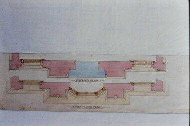 Kew Historical Society Inc
Slide - Architectural Drawing, Kew Public Offices, 1887
A civic campaign for new public offices developed in Kew in the 1880s. After much deliberation, the location chosen was the junction of Bulleen and Cotham Roads. The buildings were designed by George Watson and John Henry Harvey, architects within the Department of Public Works (Victoria). Building was commenced in 1887, and after one year, the buildings were opened. The Post Office was transferred to the new Commonwealth Government in 1901. The Police Station and Court House, sold by the Victorian Government to the City of Boroondara in 2007, are now a community cultural centre and performing arts venue.The buildings were listed on the Victorian Heritage Register Register (HO885) in 1991. They are historically and architecturally significant to the State Of Victoria because Watson and Harvey's designs exhibit diversity in integrating civil offices, they accommodate the apex of road junctions, and they demonstrate a departure from the contemporaneously favoured High Victorian Classical to the Queen Anne style in the design of civic buildings. 35mm colour transparency of an original plan by George Watson and John Henry Harvey, architects of the Department of Public Works (Victoria), in 1887 for New Public Offices at Kew. This plan was copied by the donor from an original held at the Commonwealth Archives in Brighton (Vic). The copy was made to illustrate a report that the donor made on ‘The functional planning design, building materials and construction methods of the Kew Post Office’ as part of course work at RMIT.GROUND PLAN / FIRST FLOOR PLANkew court house, kew police station, kew post office, architectural drawings, khs - slides, new public offices -- kew (vic.), architecture — queen anne style -
 Vision Australia
Plan - Image, Royal Victorian Institute for the Blind Extension to Bulk Store, 27/8/1925 (according to Mosiac entry)
In this undated drawing, believed to have been done in 1925, an existing bluestone store was extended out into the courtyard area. The extensions were on the south and west elevations, and the drawing includes a floor plan of these areas. Noted on the plan is the removal of fireplaces that existed in this building, the location abutting the Alfred Hospital reserve and location of the motor room.1 architectural plan of extension to bulk storeStephenson & Meldrum, Architects 374 Little Collins Street Melbourne Phone: 6990 On the back: Widening of old bluestone store plans & specroyal victorian institute for the blind, plans -
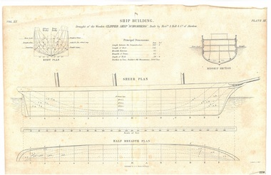 Flagstaff Hill Maritime Museum and Village
Drawing - Vessel Line Drawing, Ship Building Clipper Ship Schomberg, 1855-1876
This draft plan, a line etching, is of the wooden clipper ship "Schomberg" . It can be assumed from the heading "Ship Building." and the phrase "Built by Messrs. A Hall & Co. of Aberdeen" that the drawing is an example of plans for building a ship, and that the Schomberg ship has chosen to demonstrate this. The plan may have possibly been in a book, as it is made from two well-joined pieces of paper. The original plans would have been drawn up, discussed, reviewed and drawn in more detail before the building of the ship in Aberdeen, Scotland, in 1855. Information on the draft Is as follows: “Principal dimensions: Length between the perpendiculars: 262 feet 6 inches Length of keel 245 feet Breadth extreme: 45 feet Breadth of frame: 42 feet Depth of hold: 29 feet 9 inches Burthen in tons, Builders Old Measurement: 2600 Tons” The publisher firm A & C Black, was founded by Adam and Charles Black in Edinburgh in 1807. Over the years the company has published editions of Encyclopedia Britannica and Whose Who, and reference books, guides and technical books. The printer G Aikman (1788-1865) or his son G Aikman (1830-1905), were both named George. George senior was an early-19th century Scottish printer and publisher. After his death his son became the sole proprietor of the firm until he sold it in 1876. The draft plan uses the vessel Schomberg as its example ship building plan for demonstration purposes. It is significant for its association with the Victorian Heritage Registered shipwreck, the Schomberg. It is an example of a shipo building plan. The Schomberg collection is primarily significant because of the relationship between the objects, as together they have a high potential to interpret the story of the Schomberg. The Schomberg collection is archaeologically significant as the remains of an international passenger ship. The shipwreck collection is historically significant for representing aspects of Victoria’s shipping history and its potential to interpret sub-theme 1.5 of Victoria’s Framework of Historical Themes (living with natural processes). The collection is also historically significant for its association with the shipwreck and the ship, which was designed to be fastest and most luxurious of its day. The Schomberg collection meets the following criteria for assessment: Criterion A: Importance to the course, or pattern, of Victoria’s cultural history. Criterion B: Possession of uncommon, rare or endangered aspects of Victoria’s cultural history. Criterion C: Potential to yield information that will contribute to an understanding of Victoria’s cultural history.Plan; line engraving; draft of the wooden clipper ship 'Schomberg', built in 1855. The drawing on cream paper is made from two well- joined pages. The drawing gives the principal dimensions and labels for the Body Plan, Middle Section, Sheer Plan and Half Breadth Plan. Inscriptions are on the drawing and its rough cardboard storage folder. Publisher: A & C Black. Edinburgh. Printer: G. Aikman sc. EdinborughOn drawing: "SHIP BUILDING" "Draught of the Wooden CLIPPER SHIP SCHOMBERG", Buiilt by Messrs A Halt & Co. of Aberdeen" "Vol XX" "Plate III" "Principal Dimensions""BODY PLAN" "MIDDLE SECTION" "SHEER PLAN" "HALF BREDTH PLAN" "Published by A & C Black, Edinburgh" "G Aikman sc. Edinr" On storage folder: "Receipt Number 381A: "Line engraving draught of wooden ship "Schomberg" "warrnambool, flagstaff-hill-maritime-museum, shipwreck-coast, schomberg, schomberg plan, vessel schomberg, ship building, g. aikman ship plan draftsman, a.& c. black publisher aberdoon, a. hall & co. maker aberdeen, peterborough, clipper ship, captain forbes, black ball line, ship's plan, ship's drawing, line drawing, vessel plan, draft plan, line engraving, vol xx plate iii, a & c black, ship building example drawing, g aikman, 19th century -
 Flagstaff Hill Maritime Museum and Village
Plan - Lines Plan, S.S. Rowitta, ca 1909
The lines plan was drawn for the building of the steamship S.S. Rowitta, a passenger steam ferry built in Hobart for use in Tasmania's rivers, the Derwent and the Tamar. It is a copy of the original lines plan. The S.S. Rowitta was built by Purdon & Featherstone, at Battery Point, Hobart (Tasmania) in 1909 from Huon Pine and Kauri planking. Her final configuration included three masts and a ship rig. S.S. Rowitta took its first voyage from Hobart to Launceston in 1909 and operated for 30 years as a passenger ferry on the Tamar and Derwent Rivers. She also served as a freighter, an army supply ship, a luxury charter ferry and a floating restaurant as well as a prawn boat at Lakes Entrance. (She has also been named “Sorrento” and “Tarkarri”.). In the very early days of Flagstaff Hill ‘Rowitta’ was purchased from Lakes Entrance by Warrnambool City Council and the Victorian State Government for $20,000. The Rowitta had a hull configuration very similar to a local boat named the SPECULANT, which played a key role in the Port of Warrnambool in the early 1900s. The Speculant was the largest ship ever registered with Warrnambool as her home port. Local owner and trader P J McGennan & Co, (Peter McGennan) used her as a freight carrier to Melbourne and timber trader between New Zealand and Victoria. She sunk at Cape Otway in 1911 on a voyage to Melbourne. In 1974 Rowitta was delivered to Port Fairy and then later sailed to Warrnambool’s Breakwater where she was lifted out of Lady Bay and loaded onto the back of a long transport truck and slowly and carefully driven along Pertobe Road, through the Surfside Caravan Park and over the railway line, into Flagstaff Hill’s Maritime Village. Transfer arrangements were coordinated by Jack Morse, of Morse Engineering, a member of the Flagstaff Hill Planning Board, and Ken Goyen, a local crane operator. The ‘Rowitta’ was originally acquired to be rebuilt to match the original SPECULANT. When finances became tight in 1976 a review of all plans ended in the decision to restore the “Rowitta” to her original configuration. She was then restored, renamed the original name of “Rowitta” and installed in the Village’s Harbour Lake to become one of the popular vessels on display for visitors to enjoy. It was the decision of the Advisory Committee to Flagstaff Hill to have Rowitta demolished in April 2015 due to extensive deterioration. Items associated with the Rowitta continue to be held in Flagstaff Hill Maritime Village’s Collection.The lines plan of the passenger ferry S.S. Rowitta.is significant for its association with Tasmanian history from the early to mid-1900s. It is also connected to the history of the Rowitta, which was a large exhibit on display at Flagstaff Hill Maritime Village from the museum’s early beginnings until the vessel’s end of life 40 years later. The Rowitta represents the importance of coastal traders to transport, trade and communication along the coast of Victoria, between states, and in Australia before rail and motor vehicles. The vessel was an example of a ferry built in the early 20th century that served many different roles over its lifetime of over 100 years. Lines Plan, copy, of the steamship S.S. Rowitta. Rectangular drawing paper with copy of the hand drawn lines plan showing several profiles of the vessel. The vessel was built in 1909 by Purdon & Featherstone, Hobart. On the revers is handwritten inscription, and a white label with a handwritten number.Printed on the plan: "S.S. ROWITTA / LINES PLAN / SCALE 1/4" TO 12" " Blue ink writing on the back: "Rowitta" Blue ink on label: "56"flagstaff hill, warrnambool, shipwrecked-coast, flagstaff-hill, flagstaff-hill-maritime-museum, maritime-museum, shipwreck-coast, flagstaff-hill-maritime-village, photograph, s.s. rowitta, charles street wharf,, launceston., purdon & featherstone, rowitta, tarkarri, speculant, purdon & featherstone of hobart, passenger ferry 1909, sorrento, lines drawing, ship's plan, lines plan, line plan, shipbuilding, ferry -
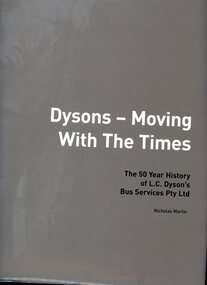 Greensborough Historical Society
Book, Nicholas Martin, Dysons - moving with the times: the first 50 years of L. C' Dyson's Bus Services Pty Ltd, 2002
... Martin Strategic Planning ...112 p., black and white photographs, with gold dust jacketnon-fictiondyson's bus services pty ltd, public transport victoria -
![Book, Garrie Hutchinson, Remember them : a guide to Victoria's wartime heritage / [written & photographed by Garrie Hutchinson], 2009](/media/collectors/4f729f7b97f83e03086018a5/items/59278b33d0cdd112c0eaedec/item-media/5bac35ae21eafa1568280d77/item-fit-380x285.jpg) Eltham District Historical Society Inc
Eltham District Historical Society IncBook, Garrie Hutchinson, Remember them : a guide to Victoria's wartime heritage / [written & photographed by Garrie Hutchinson], 2009
... Victoria. Dept. of Planning and Community Development. ...Hardback; xii, 308 p. : col. ill., maps ; 24 cm. ISBN 9781740668408war memorials, monuments, world war 1, world war ii, boer war, victoria -
Federation University Historical Collection
Book, Ballarat Regional Boad for Planning and Development, Ballarat Business Directory, 1993, 1993
... Ballarat Regional Boad for Planning and Development ...Green soft covered book business, industry, ballarat, trades -
Federation University Historical Collection
Report, Read Sturgess and Associates Consulting Economists et al, The Economic Significance of Grampians National Park, 1994 (and other reports), 1990-4
... Hassell Planning Consultants ....1) Grampians Surround Strategy, 1990 .2) Tourism and the Grampians Region: A Background Paper, 1990 .3) Grampians Surround Strategy and Discussion Paper, 1991 .4) The Economic Significance of Grampians National Park for the Department of Conservation and Natural Resources, 1994Notes in pencil by Mary Hollick, lecturer in Tourism at the University of Ballarat.victorian tourisim industry, tourism, halls gap, grampians, grampians national park, recreation, water production, bee keeping, arapiles, dunkeld, balmoral, pomonal, wartook, population, agriculture, water supplies, minerals, hamilton, ararat, stawell, horsham, wimmera, koorie heritage, aboriginal heritage, koorie art sites, brambuk, waterways, wannon river, wimmera river, mount william creek, rocklands reservoir, lake lonsdale, lake fyans, lake toolando, cherrypool, mirranatwa, zumstein -
Port Melbourne Historical & Preservation Society
Document - CD-ROM, Strategic Planning Unit, City of Port Phillip, Port Phillip Heritage Review, Dec 2000
... Strategic Planning Unit, City of Port Phillip ..."Port Phillip Heritage Review" . Plastic CD case with red insert photos of historic buildings in band along bottom. City of Port Phillip logo top right . December 2000 in ink on coverPort Phillip Heritage Review Version 2, 2000local government - city of port phillip, stategic planning, heritage review -
Clunes Museum
Pamphlet - BROCHURE HEPBURN FEDERATION TRAIL, TERRY HOPE
... BARON PLANNING & PROJECTS AND LIVING HISTORY ...HEPBURN FEDERATION TRAIL, BUILDING, COMMUNITIES, CREATING A NATION. A DRIVING TRAILTHOUGH THE SHORE, REVEALING STORIES ABOUT ITS PLACES, PEOPLE AND EVENTS. THE TRIAL EXPLORES THE CONNECTION BETWEEN THE NATURAL FEATURES OF THE SHIRE AND ITS SETTLEMENT SINCE TJE DJA DJA WRUNG PEOPLE FIRST MADE IT THEIR HOMEhepburn federation trail, dja dja wrung -
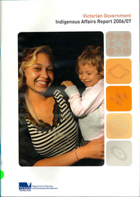 Victorian Aboriginal Corporation for Languages
Periodical, Department of Planning and Community Development, Victorian Government Indigenous affairs report 2006-07, 2007
... Department of Planning and Community Development ...colour photographs, graphs, tablesgovernment policy, indigenous affairs, native title, literacy and numeracy, family violence, economic development, vcal -
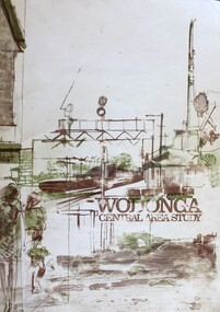 Wodonga & District Historical Society Inc
Book - Wodonga Central Area Study, Loder and Bayly, Planning & Engineering Consultants, March 1975
... Loder and Bayly, Planning & Engineering Consultants ...This report was the result of an investigation into the potential future development and town planning for the central area of Wodonga. Chapters of the final report are:- Chapter 1: Summary: Conclusions and Recommendations, Chapter 2: Setting the scene, Chapter 3: Possible futures, Chapter 4: Objectives, Chapter 5: Growth Options, Chapter 6: Recommended approaches, Chapter 7: Plan elements and Chapter 8: Ways and Means.A report of 134 pages, including illustrations and maps. The report was presented to the Albury-Wodonga Development Corporation and the Rural City of Wodonga.This report was the result of an investigation into the potential future development and town planning for the central area of Wodonga. Chapters of the final report are:- Chapter 1: Summary: Conclusions and Recommendations, Chapter 2: Setting the scene, Chapter 3: Possible futures, Chapter 4: Objectives, Chapter 5: Growth Options, Chapter 6: Recommended approaches, Chapter 7: Plan elements and Chapter 8: Ways and Means.wodonga town planning, albury-wodonga development, rural city of wodonga -
Lakes Entrance Historical Society
Book, East Gippsland Regional Planning Committee, Sites of Historical Significance in the East Gippsland Region, 1980
... East Gippsland Regional Planning Committee ...A description list of sits of historical significance in teh East Gippsland Region Victoria as at 1979-1980. A bibliography of historical material in published form is also included. Illustrationheritage, social history -
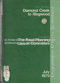 Eltham District Historical Society Inc
Book, The Road Planning Liaison Committee, Outer Ring Study, Diamond Creek to Ringwood: Environmental Effects Statement, July 1979
... The Road Planning Liaison Committee ...Prepared by The Road Planning Liaison Committee. The Outer Ring Study, Diamond Creek to Ringwood was a long term planning study carried out under the direction of the Road Planning Liaison Committee for the Government of Victoria. .. The basic aim of the .. Study was to determine the most appropriate future road system in the area between Diamond Creek and Ringwood, consistent with local and regional concerns and the environment of the area, with a view to seeking an emendment to the Metropolitan Planning Scheme to preserve the option to implement an appropriate road system some time in the future if this was considered necessary.non-fictionPrepared by The Road Planning Liaison Committee. The Outer Ring Study, Diamond Creek to Ringwood was a long term planning study carried out under the direction of the Road Planning Liaison Committee for the Government of Victoria. .. The basic aim of the .. Study was to determine the most appropriate future road system in the area between Diamond Creek and Ringwood, consistent with local and regional concerns and the environment of the area, with a view to seeking an emendment to the Metropolitan Planning Scheme to preserve the option to implement an appropriate road system some time in the future if this was considered necessary.roads, freeways, melbourne ring road -
 Eltham District Historical Society Inc
Book, The Joint Road Planning Group, Outer Ring Study, Diamond Creek to Ringwood: Technical Report Transport and Economic Evaluation, July 1979
... The Joint Road Planning Group ...Prepared for The Road Planning Liaison Committee by The Joint Road Planning Group. The Outer Ring Study, Diamond Creek to Ringwood was a long term planning study carried out under the direction of the Road Planning Liaison Committee for the Government of Victoria. .. The basic aim of the .. Study was to determine the most appropriate future road system in the area between Diamond Creek and Ringwood, consistent with local and regional concerns and the environment of the area, with a view to seeking an emendment to the Metropolitan Planning Scheme to preserve the option to implement an appropriate road system some time in the future if this was considered necessary. This technical report discusses, in detail, the transport and economic aspects of the investigation.. the techniques used take into account the long term implications of a range of possible travel cost policies and options and land use strategies.non-fictionPrepared for The Road Planning Liaison Committee by The Joint Road Planning Group. The Outer Ring Study, Diamond Creek to Ringwood was a long term planning study carried out under the direction of the Road Planning Liaison Committee for the Government of Victoria. .. The basic aim of the .. Study was to determine the most appropriate future road system in the area between Diamond Creek and Ringwood, consistent with local and regional concerns and the environment of the area, with a view to seeking an emendment to the Metropolitan Planning Scheme to preserve the option to implement an appropriate road system some time in the future if this was considered necessary. This technical report discusses, in detail, the transport and economic aspects of the investigation.. the techniques used take into account the long term implications of a range of possible travel cost policies and options and land use strategies.melbourne ring road, roads, freeways -
Clunes Museum
Book, PUBLIC AFFAIRS BRANCH DEPARTMENT OF PLANNING & DEVELOPMENT, A GUIDELINE FOR ALTERATIONS AND ADDITIONS TO HISTORIC BUILDINGS, 1993
... PUBLIC AFFAIRS BRANCH DEPARTMENT OF PLANNING & DEVELOPMENT ...A GUIDELINE FOR ALTERATIONS AND ADDITIONS TO HISTORIC BUILDINGSlocal history, book, reference, victorian historical buildings