Showing 639 items
matching public park
-
 Mission to Seafarers Victoria
Magazine (item) - Newsletter, Mission to Seafarers Victoria, Ship to Shore , Issue Autumn 2003, Spring 2002
Ship to Shore was first printed in 1997. Inspired by the Jottings From Our Log, this modern version is generally published quarterly (Summer, Autumn, Winter, Spring) Articles are written by the mission's staff and give updates about shipping and seafaring news, staff, events, board Committee, heritage. It is sent by post or email to supporters, members, volunteers and friends of the mission. It is also available to the public in the Flying Angel club and online on the website. February 2003: Mariner's frontpage. 8 December 2002: HLG reunionShip to Shore is a valable source of informationship to shore, mission to seamen, mission to seafarers, flinders street, melbourne, victoria, news, events, seafaring life, shipping, sailors, seamen, sponsors, marketing, flying angel, staff, chaplains, community, welfare, board members, 1998, portland mission, hastings mission, noyoun park, ted cosens, statistics, sea sunday, 2001, bill romney, reverend bishop jeremy ashton, nigel porteous, shipping sector, keith dann, roy hope, geelong mission, international year of volunteers, lhlg, ladies harbour lights guild, heritage, judy douglas, noah park, donors, volunteers, maria culka, hlg, beverley kent nee oliver, ro kent, pat dann, abc news, betty ashton, xmas, christmas, joan leslie, ron reid, elizabeth fiddian, barbara bedford, reverend bill dalling, joy stanfield, lal simpson, audrey adderson, gwynne scott, pauline moye, marjorie duckett nee maclennan, three faithfuls, annette wood, don dunlop, bryan reid, christine edward, sadie wilson, andy knox, poem -
 Greensborough Historical Society
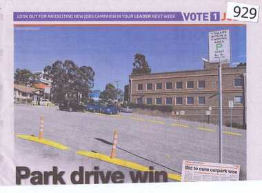
Newspaper clipping, Diamond Valley Leader, Park drive win, 24/07/2013
A car park adjacent to the Greensborough Station was the subject of concern when $10 per day parking meters were installed. Fees have been cut to a maximum of $4 per day following complaints from the public.Text and colour image.greensborough station, wayne phillips, banyule council, car parking, banyule city council -
 Greensborough Historical Society
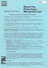
Newsletter, Melbourne & Metropolitan Board of Works, Master Plan Plenty Gorge Metropolitan Park, 1991_06
The Parks Division of the Board was responsible for the preparation of a Master Plan for the management of the Plenty Gorge Metropolitan Park, comprising privately owned land and land owned by the Board and councils.The creation of the park by the Victorian government, to be managed by the Board of Works, guaranteed public access to a large area of land adjacent to the Plenty River Gorge.2p. newsletter, black ink on blue paperNewsletter No. 6plenty gorge park, plenty river -
 Greensborough Historical Society
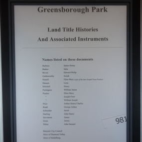
Folder of Documents, Greensborough Park: Land Title Histories and Associated Instruments, 1872-1976
Land title documents trace the ownership of what is now known as Greensborough Park from 1872 to 1976.This property was owned at various times by well known Greensborough identities. The documents show the change from private ownership to public ownership of the site.Folder of copies of land title documents. 20 pages. Includes CD of electronic copies.greensborough park, banyule city council, shire of heidelberg, shire of diamond valley -
 Glenelg Shire Council Cultural Collection
Postcard - Postcard - Hospital Portland , Victoria, n.d
Black and white photo postcard. View of old Portland hospital, taken from street (Bentinck or Fern). Buildings obscured by large trees, and high stone fence. Nurse standing either side of metal gate, with a 'PORTLAND HOSPITAL' sign on it. Woman in a two-seater roadster parked near gate. A man and 2 nurses can be seen in the groundsFront: 'THE PUBLIC HOSPITAL, PORTLAND VIC. TOYE, PHOTO' - white script on black bottom border Back: Purple stamp: 'TOYE BROS. Photographers, Hamilton & Portland' -
 Halls Gap & Grampians Historical Society
Photograph - B/W
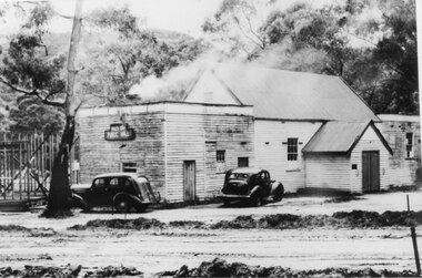
This photo is of the original Halls Gap Public Hall. For a history of the hall see record 389.The photo shows a large weatherboard building. The right hand side has a pitched roof and a small entrance area, also with a pitched roof. The left hand side is square and has a flat roof. There is a sign on the left hand side which reads "Halls Gap Public Hall". There are two cars parked near the hall and the framework of another structure, and a gum tree, can be seen to the far left. There is a range visible in the background, and a muddy road/track in the foreground.buildings, halls -
 Eltham District Historical Society Inc
Negative - Photograph, Cricket match, Central Park, Eltham, c.1931
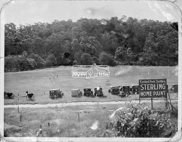
The new Central Park was opened on Monday, 21 April 1930 by Mr. W.H. Everard, M.L.A. followed by a sports carnival. The Advertiser reported on Friday, April 25, 1930 that – “Perfect weather prevailed on Monday for the sports gathering in aid of the recently-acquired park near the railway station, and from every point of view the day was a success. The Central Park contains 9½ acres, and has the Diamond Creek on one side and the railway line on the other. It cost £760, of which the council contributed £500, and the citizens, are finding the balance. Already about £80 has been spent in levelling, and a pavilion has been erected by the footballers, who will use the ground for training until it is sufficiently, improved for matches. There is ample shade along the banks of the creek, where there were numerous picnic parties. The committee has already done some planting on the railway side of the park, and where the trees grow on the higher side, overlooking the arena, the natural stand will have shade, command a view of the events, and have the trees on the banks of the creek in the distance. There were between 600 and 700 people present, many in motor cars having a little difficulty in, finding their way under the aqueduct to the ground, but the council is at present effecting improvements to the road. A merry-go round was a source of pleasure to the children, and the Northcote Soldiers and Citizens Band under Bandmaster Gore, de-lighted everyone with their varied selections of good music.” “Cr. E. J. Andrew, president of the Park Committee, said it was the first function held in the park, and although the citizens have guaranteed £420 towards it, there is still some-thing owing. Mr. W. H. Everard, M.L.A., who can always be relied upon to attend any gathering which draws the people together, said that he and Mrs. Everard had great pleasure in being present to declare the park open. He congratulated the Eltham people upon their public spirit, and the new park would be more appreciated in years to come. The other park is a splendid one, but it is far away, and one is required close to the station, so that young people can have a day's enjoyment, without having to go far from the station. The trouble in Victoria is not having enough parks. The early settlers did a lot in getting park lands, but the present generation is not doing enough. Eltham people are entitled to the highest commendation for their action, and Cr. Andrew and the council are to be thanked for what they have done. What is wanted is ingress and egress so that people can get in comfortably. When he was motoring in his wife said, "Surely you are not going down that precipice," and he replied that he would go anywhere where the people were. In the future it will be the big centre of Eltham.” Reproduced on page 96 of 'Pioneers & Painters'This photo forms part of a collection of photographs gathered by the Shire of Eltham for their centenary project book,"Pioneers and Painters: 100 years of the Shire of Eltham" by Alan Marshall (1971). The collection of over 500 images is held in partnership between Eltham District Historical Society and Yarra Plenty Regional Library (Eltham Library) and is now formally known as the 'The Shire of Eltham Pioneers Photograph Collection.' It is significant in being the first community sourced collection representing the places and people of the Shire's first one hundred years.Digital image 4 x 5 inch B&W Neg 9 x12.5 cm printsepp, shire of eltham pioneers photograph collection, eltham, eltham central park, automobile, central park, cricket match, pioneers and painters -
 Eltham District Historical Society Inc
Photograph, Liz Pidgeon, Heritage Excursion; Eltham Lower Park Walk and Talk, 1 July 2017, 1 July 2017
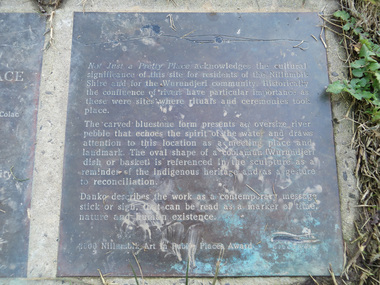
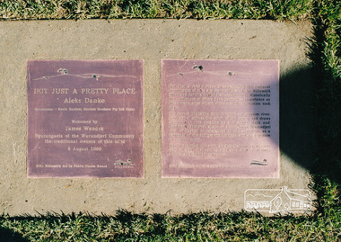
Transcription of plaque: Not Just a Pretty Place acknowledges the cultural significance of this site for residnets of the Nillumbik Shire and for the Wurundjeri community. Historically the confluence of rivers have particular importance as these were sites where rituals and ceremonies took place. The carved bluestone form presents an oversize river pebble that echoes the spirit of the water and draws attention to this location as a meeting place and landmark. The oval shape of a coolamun (Wurundjeri dish or basket) is referenced in the sculpture as a reminder of the indigenous heritage and as a gesture to reconciliation Danko describes the work as a contemporary message stick or sign, that can be read as a merker of time, nature and human existance. 2000 Nillumbik Art in Public Places Award. Heritage Excursion - Saturday 1st July - Eltham Lower Park - Walk and Talk Eltham Lower Park has played an important part in the history of our area since the early days of European settlement when it was used by local residents as an informal racecourse. Prior to that its location at the junction of the Diamond Creek and the Yarra River made it an important meeting place for the Wurundjeri people. The park combines formal elements and sporting facilities with remnant bushland that is of environmental significance. It is home to sporting and horse riding clubs, popular play spaces and the Diamond Valley Miniature Railway, which attracts large numbers of visitors. The park will be the venue for our July excursion which will comprise a walk of about 3.5 km around the park and adjacent areas. Along the way we will discuss the history and natural history of the area. The path along the creek and the river provides a pleasant and scenic walk. This walk on Saturday 1st July is about 3.5 km in length and will take 2 to 2.5 hours. It will start at 2pm at the Main Road car park at the front of the park. (Melway ref 21 H 10). From Newsletter No., 234, June 2017 Born Digitalelection day, heritage excursion, activities, eltham district historical society, eltham lower park, not just a pretty place, public art, plaque -
 Eltham District Historical Society Inc
Photograph, Public toilets, Were Street, Montmorency, c.1990
... . montmorency public tiolets were street Parks Public Toilets shopping ...Photographs of public land in Were Street, Montmorency with public toilets. Before the the erection of the wind mill. Brick paved footpath, angle parking and two public phone boxes.6 colour photographs (2 sets)montmorency, public tiolets, were street, parks, public toilets, shopping centres -
 Eltham District Historical Society Inc
Photograph, Entrance to Shire of Eltham Memorial Park, Garden Hill, Eltham-Yarra Glen Road, Kangaroo Ground, c.1923
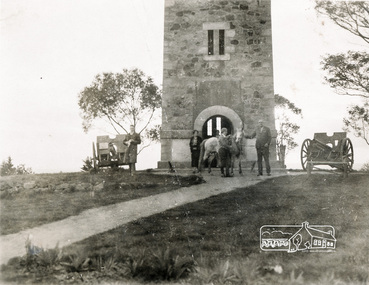
View to south-east from Shire of Eltham Soldiers' Memorial Park showing the carriageway from the road to top of Memorial Park. Accompanying notes state that the entry gate was put in place in May 1921. Eltham and Whittlesea Shire Advertiser and Diamond Creek Valley Advocate Fri 21 May 1920 p 2 reported: Kangaroo Ground Memorial Park "It was decided to arrange for a working bee on Saturday, 29th inst., for the purpose of forming and gravelling the track leading to the Park, and of carrying out other necessary works." A history summary of the Shire of Eltham Soldiers’ Memorial Park • The summit at Garden Hill was a popular tourist lookout and picnic spot from the 1880s. Virtually the entire Shire of Eltham and beyond could be viewed from this location. • A local farmer, Mr Walter A. D. Wippell is credited as being the first to propose the idea of a war memorial park and offered £50 towards the purchase of the land. • The earliest public reference to this project is to be found in the local Advertiser newspaper edition of August 9th, 1918. A report of the August Council meeting records the Eltham Shire President, Cr. Robert White, saying: "some time back it was proposed that the Council obtain and place on an Honour Board in the Council Chamber [at Kangaroo Ground] containing names of the lads who had enlisted. Just recently however, it had been suggested that a more fitting memorial would be the obtaining of a piece of land on the summit of Garden Hill, Kangaroo Ground, and the formation of a memorial park in which a monument could be erected to represent the whole of Shire. If a couple of acres could be obtained a gentleman had promised to donate 50 pounds, and another one would fence it, and other contributions, he was sure, could be obtained." • Councillors were favourable of the proposal and the President, Shire Secretary and Shire Engineer were deputised to wait on Messrs Mess Bros. (the owners of the Garden Hill farm) and ascertain if they would gratuitously give the land. The Mess Bros. land adjoined the farm/stud of Mrs Fanny White (Cr Robert White’s mother), daughter of Andrew Harkness who established their property on Garden Hill around 1846. • Access to the land came in February 1919 when several Councillors and the Shire Engineer surveyed the actual two acres of '5 chains along the road and 4 chains deep'. The Engineer volunteered his services free to do this task. The Mess brothers however demanded £100 per acre but eventually agreed to take £50 per acre. • Entry from the Kangaroo Ground-Yarra Glen road was seen to be a problem and Mrs. White, who owned the land beside the park, was asked to donated a triangle of her property to allow this access. • By September 1919 returned soldiers were employed by the Shire and volunteers were called to clear the hilltop by ploughing up the rocks and clearing the area, the fencing was put into place and in May 1921 the Council erected three gates, within an archway, at the entrance to the drive and pathway to the summit. • Public subscriptions were sought through the Advertiser newspaper to beautify the site. The views of the Curator of the Melbourne Botanical Gardens were sought as to the ‘class of ornamental trees most suitable for planting in the Park area”. • The Memorial Park or Shire of Eltham Soldiers’ Memorial Park was officially opened by Mr. W.H. Everard, M.L.A., 3 September 1921. • In 1922 plans were made to place a War Memorial in the Park. Funds were donated by the Council of £250 and a challenge to the community, to match this money with contributions was met. • On Anzac Day 1923, 1,000 people gathered on the summit in the park for a memorial service. A much smaller group of about 50 people gathered around a newly constructed cairn and flagstaff in the afternoon of Anzac Day 1924 amidst rain and a squally southerly wind, the morning service being cancelled. • A meeting for those interested in establishing a War Memorial monument within the park was held in January 1924 and the Eltham Shire War Memorial League was formed and a design competition decided upon. • The Shire of Eltham War Memorial tower was built in 1926 at a cost of £1,023 and 5 shillings with locally quarried stone donated by Dr Ethel and Professor William Osborne. It was formally known as the ‘Shire of Eltham War Memorial’ and was unveiled on 11 November 1926. The large bronze inscription above the entrance to the tower states: SHIRE OF ELTHAM WAR MEMORIAL THESE MEN DIED FOR THEIR COUNTRY 1914 IN REMEMBRANCE THIS TOWER WAS BUILT 1918 • The Caretaker’s hut was built in 1927 with left over from the tower construction. • A returned soldier was appointed to act as caretaker for the memorials. Tiny Carrol, a huge man, was the first caretaker and lived in the stone hut. There was a push to have alterations made at one stage to provide additional rooms for a married caretaker but was rejected. • A new Caretaker Cottage was built in 1951 at a cost £2,500. The cottage had been subjected to raids by thieves three times during construction until a guard from the Returned Servicemen’s League was posted until its opening. • The War Memorial tower was re-dedicated by Sir Dallas Brooks on 8 November 1951, unveiling new bronze plaques containing the names of those who fell during the Second World War. Sir Dallas also officiated the opening of the new Caretaker’s Cottage. • A toilet block was built in 1965. • A further dedication of the Shire of Eltham War Memorial tower took place 11 November 2001 to recognise the men who fell in subsequent campaigns up to and including Vietnam. • Four land titles are involved: o The purchase of the two acres from owners Ruth Gosling, Alexander Mess, James Johnson Mess and Joseph Mess is recorded in two actions, the first being the payment of £100 for the two acres, the second showing that the Shire of Eltham did not get a transfer of title until 14th January 1952. o The access land donated by Mrs. Fanny White is dated 26 February 1924. A further need to widen the entry came after the deepening of the road cutting and another land donation was given by Sir Herbert Gepp, title dated 15th May 1952. This would have been about the time he sold off the former White ‘Garden Hill’ property. o The land reserve to increase the area and possibly allow a circuit road to be put in place on the western side of the park was purchased by the Shire of Eltham, title dated 16th February 1973. Rare photograph of the entrance to the Shire's Memorial Park during early stages of development prior to the erection of the Shire of Eltham War MemorialSepia photograph printed with white border with slight crack lower left hand corner and three significant vertical cracks fanning from lower centre edge to upper edge Digitally enhanced version to minimise impact of crackseltham-yarra glen road, entrance gate, garden hill, kangaroo ground, shire of eltham memorial park, shire of eltham war memorial, kangaroo ground war memorial park -
 Eltham District Historical Society Inc
Photograph, Memorial Tower, Kangaroo Ground c.1934, 1934c
Sepia photograph of Joyce McMahon and 'Tiny' Carroll at the War Memorial Tower, Kangaroo Ground c.1934. The guns were installed in 1934 and removed in 1942. Taken in the early 1930s, the photograph ... shows the Kangaroo Ground Tower of Remembance with Joyce McMahon, daughter-in-law of Mr. P. J.McMahon, the then Shire of Eltham Secretary, her horse and a very tall person patting the horse. He is ex-serviceman W. "Tiny" Caroll who was the council's caretaker of the surrounding War Memorial Park. He lived in the stone cottage which still stands in the park. "Tiny" is seen as the fictional character "Tiny Bourke" who, in author Alan Marshall's book "This is the Grass", "was a giant of a man, well over six feet high, with huge hands that completely encircled the cup of tea". The bronze casting, which shows the 79 names of those who paid the "supremen sacrifice" in World War 1 (1914-1918), was erecfed above the entrance to the Tower in September, 1930. The Monterey cypress trees which now form the windbreak around the park's fenceline, were just knee high in this photograph. They were planted in August 1926, with all the plantings paid for, and done, by the public as the Tower was being erected. The two field guns have been identified as of German origin, Krupp 77 mm calibre captured on October 4, 1918 at Geneve, France. They were removed in 1943/44 as a wartime requirement of the Australian Govenment. A public notice dated October 16, 1926 by Cr. H Rutter, Chairman of the Eltham Soldiers War Memorial League stated: "On the summit of that central and conspicuous landmark, Garden Hill, there is being erected a massive memorial tower which will, for all time, remind every passerby of the part played by the men of the Shire of Eltham in the Great War. The work has been undertaken by the people of the Shire a a tribute of love and admiration for those who were known and dear to use in the days of their youth and early manhood, who went out from amongst us, never to return, and whose self-sacrifice has made us, each and all, thier ever-lasting debtors" Harry Gilham, Eltham District Historical Society Kangaroo Ground Tower of Remembrance, A Journey in Time: a column about Nillumbik's history, Nillumbik Mail, 9th August, 2000 Since that research the following has been sourced from Eltham and Whittlesea Shires Advertiser and Diamond Creek Valley Advocate, April 8, 1921, p. 3 Retrieved April 25, 2020, from http://nla.gov.au/nla.news-article57639687 Eltham Shire Council From Town Clerk, Melbourne, stating that a light machine-gun captured by the 22nd battalion, A.I.F. at La Motte Farm, near Beaurvoir, on Oct. 3rd, 1918, during the operations which won the Beauvoir line and completed the smashing of the great Hindenburg defence-system, has been alloted to the Shire of Eltham. - On the motion of Crs Hubbard and Smedley, it was decided to have the gun placed in the Memorial Park. Sepia Photographgarden hill, gun, joyce mcmahon, kangaroo ground, memorial tower, shire of eltham war memorial tower, tiny carroll, war memorials, war trophy, william carroll -
 Eltham District Historical Society Inc
Photograph, Not Just a Pretty Place, Aleks Danko (2000), Lennister Farm, Eltham South, 2000c
Not Just a Pretty Place acknowledges the cultural significance of this site for the residents of Nillumbik Shire and for the Wurrundjeri community. Historically the confluence of rivers have particular importance as these were sites where rituals and ceremonies took place. The carved bluestone form presents an oversize river pebble that echoes the spirit of the water and draws attention to this location as a meeting place an landmark. Awarded the 2000 Nillumbik Art in Public Places Award and situated behind Lennister Farm near Yarra ParkColour photograph printaleks danko, eltham, lennister farm, yarra park -
 Eltham District Historical Society Inc
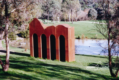
Photograph, Sculpture 'Classical Landscape' by Cliff Burtt, Alistair Knox Park, Eltham
... and won the Eltham Public Art Award in 1996. “Award winning ...Iron sculpture by Cliff Burtt welcomes visitors to the Gateway of Eltham. It was constructed of Corten Steel in 1994 and won the Eltham Public Art Award in 1996. “Award winning sculptor, Cliff Burtt, often references the geometry of architectural forms in his bold, minimalist public sculptures. In this corten steel work the repeated arches of the temples of antiquity are in dialogue with the nearby spans of the railway trestle bridge that cuts through the Eltham parkland. The formality of the architecture is offset by the organic sweeps of the top profile of the work, which playfully acknowledges the hilly topography of the region” – Highlights from the Nillumbik Art Collection Two colour photographs of iron sculptureclassical landscape, sculptures, art, parks, alistair knox park, eltham, cliff burtt, public art -
 Orbost & District Historical Society
book, Report on the East Gippsland Study Area, June 1974
In 1961 Bruce Evans was elected to the Victorian Legislative Assembly as the member for Gippsland East. He was the party's deputy leader from 1964 to 1970 and its whip from 1970 until his retirement in 1992. "The Land Conservation Council was established by the Land Conservation Act 1970. As one of its three functions, it makes recommendations to the Minister for Planning and Environment with respect to the use of public land, in order to provide for the balanced use of land in Victoria. This report contains the Council’s final recommendations concerning the use of public land in the East Gippsland study area, the boundaries of which correspond to those of the Shire of Orbost. The recommendations in the text are grouped under major headings, such as Parks, State Forest, and so on. " The Council met on seven occasions during the year, and also made visits of inspection to each study area. The Chairman visited Shire Councils in study areas to explain the role and the functions of the Land Conservation Council and to invite submissions on the use of public land in these areas. This is the fourth annual report by the council. This is a useful research tool.A large book 236 pp book with a yellow / gold cover with a green bush scene . The binding is orange. It contains folded maps and information on public land use in East Gippsland.inside - "With Compliments - Bruce Evans, M.P."east-gippsland-study-area conservation public-land-use -
 Ringwood and District Historical Society
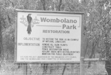
Photograph, Wombolano Park restoration sign. Heathmont. (Undated)
Sign reads as follows, "Wombolano Park restoration. Objective - to restore the park as an example of natural landscape. Implementation - Remove all alien plants, construct trails, fence restoration areas, replant areas with Australian natives, maintain for public enjoyment. A 5 year project undertaken by the Ringwood City Council and the Wombolano Park Committee of Management". -
 Ringwood and District Historical Society
Document, Packet: Ringwood Elderly Citizens Club correspondence and clippings 1961-1968
Letter re Aged Care Home - 1961; Correspondence re Charity Ball - 1961; Clubrooms opened 1964 Greenwood Park; Photograph of opening of Clubrooms; Ringwood East Clubrooms opened 1968; Newspaper clipping, Packet includes: . Letter from Council calling for Public Meeting to consider assistance to aged citizens. . Letters from Council re Ringwood Mayor's Charity Ball. . Programme for Official Opening of Elderly Citizens Cubrooms at Greenwood Park, 2nd May 1964. . Photograph of Opening of Elderly Citizens Clubrooms 1964. Article in "Mail" dated 14 May, 1964. Photograph shows Mayoress Mrs P Vergers and Mr F Dwerryhouse, Town Clerk. . Newspaper clippings re Elderly Citizens. -
Australian Commando Association - Victoria
Mixed media - From Tidal River to Timbered Knoll, Education Package - From Tidal River to Timbered Knoll
This training package was produced by AVA Vic for use within the Victorian educational curriculum for years 10 to 12. It is particularly focused on those students who are attending Wilsons Promontory National Park and undertaking educational activities through the Parks Victoria Education Centre. The eight module program and teachers notes provides a historical workbook for students to gain a better understanding of the role of Tidal River as the initial training location for Australian and New Zealand commandos during World War II and the later military operations that were undertaken by commandos during World War II.Using original World War II footage, supplemented by later official record data this video and training package provides unique material regarding the history of Australian special operations during World War II.ww2, world war ii, independent companies, commando companies, australian special forces, tidal river -
 Ringwood and District Historical Society
Flyer, Stillwell & Stephens Pty. Ltd, Brochure - Multiple Properties for Public Auction at Box Hill, Ringwood, Wonga Park and Clarinda - 28th November, 1934
Seven-page brochure advertising Mortgagees' Realising Sale by Public Auction on Wednesday, 28th November, 1934 for properties at Box Hill, Ringwood, Wonga Park, and Clarinda (via Oakleigh), including photographs, property descriptions, and terms of sale.Auction Commencing at 2.15 p.m. in the Orient Line Auction Rooms, 352 Collins Street, Melbourne. Solicitors: Messrs. Madden, Butler, Elder & Graham, 406 Collins Street, Melbourne. (Agents) H.P. Knight & Co. Property Salesmen and Subidivisional Experts, 315 Collins Street, Melbourne, 'Phones: Central 10615, 10616. Attractive Residential, Orchard, and Market Garden Properties, and Public Hall and School Rooms. 1. Wonga Park via Ringwood - "Holme Bush" off Warrandyte Road, Part of Lots 14 and 15, Ringwood Orchard Estate, approximatgely three miles (north) of Ringwood Railway Station - 64 Acres. 2. 17 Bishop Street, Box Hill - timber residence. 3. Greenwood Avenue, Ringwood - On East Side, 150 feet 3 inches South of Bedford Road - timber attic residence. 4. Ringwood - Wantirna Road, South-east corner of Canterbury Road - Orchard Property of approx. 11-1/2 Acres. 5. Box Hill - Whitehorse Road, South-east corner of Linsley Street - Timber building utilised as a Public Hall and Private School. 6. Clarinda vic Oakleigh, Talbot Crescent, off Centre Road - Home on 10 acres of land. -
 Cheese World Museum
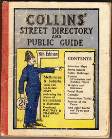
Book, Queen City Printers Pty Ltd, Collins Street Directoryand Publice Guide: 8th Edition
The Percy Uebergang family lived at Tooram Park, Allansford from 1912 until 1992. This booklet was part of the collection of items given into the care of the Cheese World Museum. Uebergang catalogue No. -not listed White hard cover pocket-sized street directory book with red cloth spine. The front cover has a blue and yellow background with title, contents, edition listed and a policeman in a blue uniform. The back cover has information in black print. Melbourne and suburbs maps throughout. 439 pages.COLLINS' STREET DIRECTORY/AND/PUBLIC GUIDE/8th Edition/2/6 each/CONTENTS/ Suburban Maps/Street Indices/Public Buildings/Tourist Information and Holiday Notes/Weights and Measures/Postal Rates/Calendar/Conversion Tables/Justices of the Peace/And other useful and up-to-date matterallansford, uebergang, street directory, public guide, collins, melbourne, maps, tourist information, queen city printers pty ltd, almanacs, local history -
 Flagstaff Hill Maritime Museum and Village
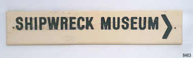
Sign - Shipwreck Museum sign, Flagstaff Hill Historic Park Planning Board, Shipwreck Museum, ca. 1975
This sign is painted on both sides. It was attached to the bluestone wall on the western wing of the Lighthouse Keeper's Quarters, the Assistant Keeper's Quarters, at Flagstaff Hill Maritime Museum and Village for almost 50 years. The Complex was opened to the public on December 11, 1975, and officially opened by Victorian Premier Sir Rupert Hamer on July 8th, 1977. The sign's reverse side reads "Loch Ard Peacock & Museum". The three rooms had displays behind glass showing various ships' fittings, cargo and personal belongings recovered from significant shipwrecks along the southwest coast of Victoria. There was also a display of information about the mysterious Mahogany Ship or Ancient Wreck. The shipwreck artefacts were recovered by local divers in the 1960s and early 1970s. Also on display was the famous Loch Ard Peacock, created in 1873, survived the shipwreck in 1878, was purchased by Flagstaff Hill in 1975 and announced as being on display in The Standard of September 15, 1975. In about 1984 the other side of the sign was painted "SHIPWRECK MUSEUM" and re-displayed on the building. The Loch Ard Peacock was by that time on display in the Entrance building; plans were underway on August 31st 1984 to build a Hall for its unique display. In February 2023 the sign was removed from the building, which was undergoing restoration and preparation for use as a new Temporary Exhibition space. The Loch Ard Peacock continued its journey around the Village; it was moved from the Entrance to the Village's newly completed Public Hal in 1986. It also spent a short time in the Stella Maris Tea Rooms. This was likely around 1998, when the Common School had moved from the Chartroom building to what had been the Public Hall. The Loch Ard Peacock was once again moved in around 2001, this time to be the central attraction and meeting place in the Great Circle Gallery, which opened on December 31st 2002. The sign continued to be displayed on the western wing of the Lighthouse Keeper's Quarters until February 2023. This wing has now been restored and re-fitted to become a facility for short-term exhibitions. A section of the original internal wall frame and wallpaper that couldn’t be kept in the building due to preservation issues have been saved and become sort of the Flagstaff Hill Collection. The sign has guided the visitors of Flagstaff Hill Maritime Museum and Village to the exhibits of artefacts from historic and significant shipwrecks. It has connected the current generations to the people and objects of the past, leading to a better understanding of our Colonial history.Sign, wooden, rectangular, with a hole through each short side. The front and reverse have different painted text. Cream paint for the background colour, green paint for the lettering, and the reverse has a white painted border. The front has an arrow painted on the right-hand side. The sign was used at Flagstaff Hill since its opening.Text on front "SHIPWRECK MUSEUM >" Text on back "LOCH ARD PEACOCK / & MUSEUM"flagstaff hill maritime museum and village, warrnambool, great ocean road, shipwreck coast, sign, building sign, shipwreck museum, loch ard peacock & museum, flagstaff hill history, assistant lighthouse keeper's cottage, assistand lighthouse keeper's quarters, public hall, common school -
Marysville & District Historical Society
Ephemera (Item) - Information brochure, Artworkz Tourism, MARYSVILLE THINGS TO DO AROUND MARYSVILLE, 27-01-2018
An information brochure on things to do around Marysville in Victoria.An information brochure on things to do around Marysville in Victoria.Disclaimer: The authors have taken care to ensure this/ publication is correct, though please be aware that/ errors and omissions do occur.marysville, victoria, australia, information brochure, gallipoli park lake, gallipoli lake, steavenson falls, steavenson river, bruno's art and sculpture garden, fernshaw park, buxton recreation reserve, taggerty river areas, anderson mill camping area, cooks mill camping area, neds gully camping area, keppel creek day area, beauty spot nature walk, gilbert gully nature walk, michaeldene track, cathedral range, the beeches walk, tree fern gully walk, crystal journey, marysville market, lake mountain ski resort, marysville golf club, marysville public outdoor swimming pool, buxton trout & salmon farm, keppel's lookout, jock's lookout, mount gordon, armstrong lookout, keppel falls, phantom falls, cora lynn falls, meeting of the waters, st ronan's well, preiffer falls, camberville historical township, keppels hut, the big culvert, the big tree, marysville historical society -
 Eltham District Historical Society Inc
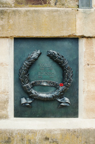
Photograph, Bronze plaque for the Korea (1950-1953) and Borneo (1962-1966) conflicts, War Memorial Tower, Kangaroo Ground
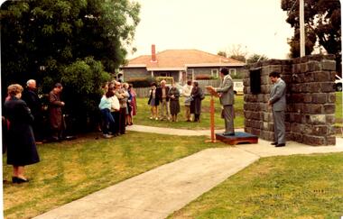
Harry Gillham, President and EDHS and Convenor of the Nillumbik Shire Council's Advisory Committee for the War memorial at Kangaroo Ground was for some years working on the refurbishment of the Tower of Rememberance and the surrounding park. The Committee decided to produce plaques to commemorate the armed conflicts in Korea, Malaysia, Borneo and Vietnam. The plaques were funded by public donations and cost $10,000. The community donated via donation boxes placed at Eltham Library. NL 140 Sept 2001 Governor John landy and other digniaries attended the event where the Governor unveiled the plaque which was attached to the historical tower in November 2001. Colour photographkangaroo ground, war memorial tower, plaques -
 Glen Eira Historical Society
Document - NEERIM ROAD RAILWAY CROSSING AND GATES GLEN HUNTLY
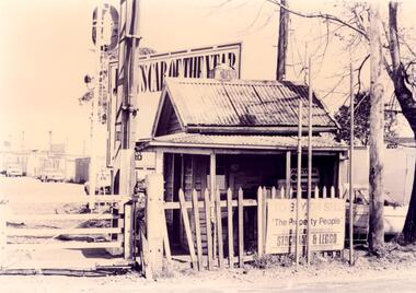
This file contains two items: 1/Twelve photographs of the Glen Huntly, Neerim Road hand-operated railway gates, dated 1983 and November 1985, photographer unknown, and two black and white copies of two of the original photographs. Four photographs are in black and white and eight are in colour, all picturing the Gatekeeper’s shelter and/or the railway gates. Six photographs dated 1985 include the Gatekeeper, unidentified, in some photos operating the gates. 2/A three-page pamphlet dated 03/05/1979 promoting a public meeting at the Caulfield Town Hall to debate Road Grade Separation proposals for the Neerim Road and Glenhuntly Road railway crossings. Document details the proposed VicRail improvement and four alternative improvements as we as a blank questionnaire for the submission of ideas regarding the proposals to the Caulfield City Council Urban Planner. A short summary of other concerns held by two councillors and an engineer regarding the proposal is also included, as is a Railway Noise Level. Railway Pamphlet also includes a map of the area surrounding the railway crossings under discussion 1977.glenhuntly road, neerim road, caulfield, railway gates, gates, hand-operated railway gates, railways, roads and streets, railway crossings, architectural features, town halls, official buildings, vicrail, meetings, public meetings, caulfield town hall, gatekeepers, caulfield city council, elsternwick, glen huntly, caulfield park, caulfield racecourse, normanby road, dandenong road, railway buildings, railway stations, land transport, transport establishments, hordern a.g., dunstan don, hordern bill, needham j.g., advertisements, graphics, advertising, advertising signs, signs, estate agents, business people, stockdale and leggo, buildings structures and establishments, occupations, united signs, signs, communication devices, motor vehicles, glenhuntly railway station, town planning, civic and landscape art, engineers, professionals, traffic, road transport, transport, maps, documents, plans -
 Glen Eira Historical Society
Letter - Rosstown Railway
This file contains two items: 1/A group of eight letters, predominantly between Hon. Secretary of Caulfield Historical Society R. Ballantyne and members of the Caulfield City Council written between 1981 and 1983, regarding the installation of a plaque in commemoration of the centenary of the Rosstown Railway. The first two letters are handwritten from R. Ballantyne to G. Calder and Carol Camy, dated 01/06/1981 and 22/02/1982. The letter to G. Calder supports a suggestion in the May edition of the CAULFIELD CONTACT for the installation of a plaque in celebration of the centenary of the Rosstown Railway, suggesting a potential site for another plaque on Curraweena Road. The letter to Carol Harry discusses the costing of the plague and a possible contribution towards this cost from the Caulfield Historical Society. The letter appears to be incomplete, having no sign off from the author. Attached to the letter is what appears to be a suggestion for the inscription of the plaque. The letters addressed to R. Ballantyne are typed and dated 12/06/1981, 24/06/1981, 14/07/19891, 17/12/1981 and 08/09/1983, from A. Craig and D.B. Hogan on behalf of City Manager G.K. Calder and City Liason Officer Carol Harry. All letters concern the commemorative plaque, with these from Carol Harry including handwritten notes which appear to be in R. Ballantyne’s handwriting. The final letter is from Mayoral Secretary Norma Polglase to Miss B. Snowball, dated 23/08/1983, inviting her to attend the unveiling of the plaque. Also included in the item are Council Committee Meeting minutes, dated 16/05/1981, broaching the subject of installing the plaque in Koornang Road. 2/Four colour photographs and two black and white copies of one of the photographs, all dated 18/09/1983 and showing the opening of the commemorative plaque in Marrara Gardens. Two photographs picture Mayor Brian Rudski and City Manager Graham Calder with a crowd of unidentified people present. One photograph and both copies are of the inscription on the plaque, with the wording identical to that of the handwritten note by R. Ballantyne, in item one.caulfield, caulfield south, calder g.k., calder g., hawthorn road, glen eira road, ballantyne r., office workers, caulfield contact, norman peter, groups, glen huntly, koornang road, mills, sugar mills, caulfield historical society, caulfield city council, caulfield town hall, official buildings, glen huntly neville street fourteen, parliamentary representatives, rosstown, rosstown railway, rosstown railway centenary, festivals and celebrations, centenaries, historical markers, plaques, monuments and memorials, ross murray, railways, land transport, curraweena road, parts of buildings or structures, bluestone structures, construction materials, caulfield community liaison officer, harry carol, currency, finances, onley peter, elsternwick, oakleigh, council meetings, caulfield council chambers, caulfield municipal chambers, caulfield municipal offices, craig a., caulfield city manager, city of caulfield, caulfield physical environment committee, public meetings, meetings, ross james, hogan o.b., arrow engraving, campbell f., snowball miss., elsternwick gladstone parade nineteen, walters w.r., marara road gardens, marara road, marara gardens, narrawong road, ceremonies, caulfield mayors, polglase norma, mayoral secretaries, railways routes, documents, correspondence, rudski brian, calder graham, events and activities, official buildings, insignia, local government, local officials and employees, parks and reserves, buildings structures and establishments, official events, festivals and celebrations, occupations, political processes, local history, history, financial economics, local government finance -
Glen Eira Historical Society
Document - History of the City of Caulfield
This file contains 4 items: 1/Typewritten document titled ‘The City of Caulfield’. Author and date unknown. 1 page (back and front), 2 copies. Document covers topics such as origins of the name ‘Caulfield’, early settlement and the Caulfield Cup. 2/Typewritten document titled ‘History of Caulfield Council’. Author and date unknown. 6 pages, 3 copies. Document covers subjects such as early settlement, Aboriginal influence, Caulfield Road Board, Shire of Caulfield, Borough and town boundaries, coat of arms, and Freedom of Entry to the City. 3/Typewritten document (undated + author unknown) titled ‘The Structure of Local Government in Victoria with a history of the City of Caulfield’. 13 pages. Covers the following subjects: Powers, Planning, Public Works, Trading Undertakings, Health Services, Municipalities, Wards Electors or Ratepayers, Voters Roll, Councillors, Officers, Finance, Nature of Soil and Vegetation, Parks and Gardens and Reserves, Coat of Arms, Boundaries, How Did Caulfield get its Name, Aboriginal Influence, Caulfield Road Board, Shire of Caulfield, Borough and Town and the City of Caulfield. Also covered is early settlement. Note at the end of the document mentions that the historical content contained in the last section was based upon a thesis for the Department of Town and Regional Planning, University of Melbourne, 1968 by L. Alwis, P. Rowe, N. Wootten. Melbourne, ‘City of Caulfield: An Illustrated City Report’. 4/Typewritten document (undated) titled ‘The Structure of Local Government in Victoria with notes on the history of the City of Caulfield’. 8 pages, 2 copies. This document also includes a map/diagram of the city with boundaries and wards showing locations of railway stations and parks. Document covers the structure of local government and its functions then goes on to focus on City of Caulfield with subjects similar to those covered in item 3. Document signed off by Deputy Town Clerk.city of caulfield, caulfield john, caulfield baron, caulfield racecourse, elsternwick, ripponlea, st. mary’s church, caulfield council, kooyong road, neerim road, bambra road, greenmeadows house, caulfield park, paddy’s swamp, dandenong road, caulfield grammar school, chisholm institute of technology, murrumbeena, glen eira road, alma road, orrong road, balaclava road, inkerman road, ‘grosmont’, caulfield school room, caulfield road board, caulfield road district, crimean war, victorian amateur turf club, caulfield cup, glenhuntly road, north road, glenhuntly station, ormond station, outer circle railway, local government, gardenvale, carnegie, rosstown, poath road, nepean highway, hotham street, ormond park, princes park, ross william murray, caulfield institute of technology, ‘ross’ folly’, hawthorn road, glenhuntly, ormond, morris t. w., lloyd charles du plan, meals on wheels, shire of caulfield, caulfield railway station, caulfield rsl, bouran road, murrum murrumbeen, kooyong road, great dandenong road, neerim road, trams, prahran and malvern tramways trust, fisher andrew, mackinnon reserve, dover street, ‘glen eira’, blair max cr., insignia, third ordnance services unit, schools, street lighting, lampriere, mr. bevan, the caulfield leader, davies j. henry, curraweena road, st. georges road, o’neill college, hope george, market gardens, koornang reserve, packer reserve, murrumbeena reserve, hopetoun gardens, greenmeadows gardens, mirambeena, caulfield technical college, hart john, langdon h. j., ‘rosecraddock’, judge webb, ‘crotonhurst’, service james, ‘kilwinning’, ricketson henry, grimwade frederick sheppard, airdrie, jenner, st. aubin’s, caulfield john p. t., harlston, lempriere, lord reserve, ‘cantala’ -
Glen Eira Historical Society
Document - Glen Eira Residents Association
Six items pertaining to Glen Eira Residents Asssociation Inc. 1/Two copies of the minutes of a Committee Meeting of Glen Eira Residents Association Inc., held on 04/12/2001. The minutes cover a range of routine meeting items, as well as the postponed release of the Princes Park Master Plans and the proposed construction of car parks at Caulfield Racecourse. 2/A copy of Glen Eira Residents’ Association Inc.’s 30/05/2003 newsletter, notifying members of matters presently before Glen Eira City Council for purposes of evaluation. Matters include an admonishment to the Council to sort out anomalies between the C25 Amendment (80/20 Plan) and the Melbourne 2030 Plan, the success at convincing the Ministerial panel to adopt GERA’s views regarding the C14 Council Plan for the Caulfield Racecourse, a request for information from the Council regarding the previous year’s rate increase, a request for information from the Council regarding spending on planning for improvements to Princes Park, a call for the Council to improve its consultative procedures, a recommendation that the purpose of Glen Eira News be expanded to the making of suggestions for city improvement, and a notification of the measures implemented to improve the visibility of Caulfield Racecourse’s usability by the public. Includes a black-and-white photograph of Orrong Road, Elsternwick, illustrating what Glen Eira’s roads would look like if lined with trees, which was excluded from Glen Eira News on account of a current prohibition on the making of suggestions for city improvements. 3/Four copies of a booklet entitled ‘A Short Guide to Planning Procedures’, composed 08/2006, which endeavours to explain, as concisely as possible, the methodology by which Glen Eira City Council approves real estate developments and issues planning permits. 4/A booklet containing the minutes of the 05/10/2009 Annual General Meeting of Glen Eira Residents’ Association Inc. Details both routine items and more specific matters of discussion, such as inappropriate charges on the part of the Glen Eira City Council and the proposed inception of a questionnaire to evaluate local residents’ opinion of the Council. 5/A booklet announcing the 07/10/2010 Annual General Meeting of Glen Eira Residents’ Association Inc. at St. John’s Uniting Church, Elsternwick. Front cover details agenda and contains four colour photographs pertaining to public transport (buses, trams, trains) within the city. Interior features president Don Dunstan reflecting on issues relevant to GERA occurring over the preceding twelve months, with an emphasis on the dubious behaviour of the City Council, as well as two colour photographs: one of Dunstan himself and one of traffic at Elsternwick Junction. The rear cover contains the Financial Statement presented to the Meeting. 6Two copies of a printout of an article from the website of Glen Eira Residents’ Association Inc., accessed 19/06/2012, explaining the affects wrought as a result of the implementation of Planning Scheme Amendment C87. Said amendment changes the Planning Scheme protecting neighbourhood character by replacing the previous Significant Character Area (SCA) designation with the new designations of Neighbourhood Character Overlay (NCO) and Design and Development Overlay (DDO). In developing the Amendment, Glen Eira City Council commissioned Planisphere to procure the Planisphere Final Report, in which recommendations regarding the expansion, creation and deletion of SCAs were offered. The article contains a summary of said recommendations.glen eira residents’ association inc., clubs and associations, glen eira, meetings, minutes, campbell jack, dunstan don, marwick geoff, pleydell max, teseriero dominic, robins kevin, princes park, south caulfield, glen eira city council, local government, councillors, brennan martin, victorian local government association (vlga), erlich mayor, project manikato, caulfield racecourse, caulfield racecourse flat, racecourses, parks, car parks, kennedy cr., kennedy norman mr., crown land, glen eira road, rippon lea, c25 plan (80/20), melbourne 2030 plan, c14 council plan, rates, orrong road, elsternwick, trees, station street, caulfield north, neerim road, glenhuntly, glenhuntly park, orrong ward, grossbard cr., martens cr., building permits, delegated planning committee (dpc), steward joy, brohier peter, campbell fliss, scutt alex, ray darren, hannah brian, st. john’s uniting church, mees paul dr., elsternwick club, sandham street, melbourne weekly bayside, glen eira debates, walsh investigation, whelen investigation, forge cheryl cr., whiteside helen mayor, save our suburbs (sos), walsh mary, walsh kevin, french christine, elsternwick junction, planning scheme, planning scheme amendment c87, significant character areas (scas), planisphere final report, oakdene crescent, carnegie, blackwood street, housing diversity areas, urandaline grove, caulfield, normanby road/park crescent, kambrook road, balaclava road, hawthorn road tramway estate, caulfield south, ulupna road, ormond, murray street, prentice street, kambea grove, chestnut street, mcpherson avenue, queens avenue, caulfield east, derby crescent, clarinda street, st. james parade/downshire road, exhibition street, mckinnon, field street, boyd park, murrumbeena, lindsay avenue, lydson street -
 Glen Eira Historical Society
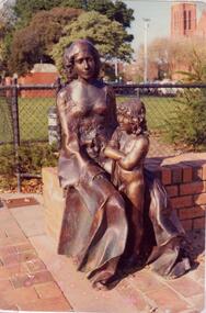
Article - Caulfield Park
This file has thirteen items. 1/Typed note date and author unknown, titled development in Caulfield Park, describing the statuses commissioned for the park in 1975. 2/Photocopies undated of photographs of two of the statues. 3/Article dated 19/03/1980 in the Southern Cross newspaper about Caulfield Councils frisbee and golf day at the park. 4/Invitation for Mr. and Mrs. Campbell to attend tree planting ceremony at Caulfield Park on 23/10/1988 to commemorate Raoul Wallenberg. 5/Black and white photograph, undated, photographer unknown, of lake and fountain at Caulfield Park. 6/Three colour photographs dated June 1982 of Caulfield park. 7/Photocopy of photograph of War Memorial at Caulfield Park. 8/Leaflet advertising a parade and fair at the park on 25/05/1997. 9/Two black and white photographs, date and photographer unknown, of conservatory at the park after it burnt down, possibly in the 1920’s. 10/Friends of Caulfield Park newsletter dated July 2007 concerning the council’s plans for the park. 11/Article dated 19/10/2011 from Melbourne Weekly Bayside about the conservatory and its future, includes photograph. 12/Article dated 07/05/2013 in the Glen Eira Leader concerning the council’s plans for the conservatory. Includes dot points that original glasshouse (ex-Ripponlea) destroyed by fire in 1977 and replaced by existing hothouse. 13/Article dated 23/07/2013 from Glen Eira/Port Phillip Leader about public society survey concerning the conservatory’s future.caulfield park, north caulfield, balaclava road, caulfield city council, cannizzo phillip, statues, sculpture, hawthorn road, meserow hale, campbell jack, campbell mrs., braun emil, huppert michelle, wallenberg raoul, fountains, parks and reserves, monuments and memorials, parades and processions, festivals and celebrations, greenhouses, conservatories, catherine street, st aloysius school hall, friends of the caulfield park., caulfield park pavillion, pavilions, sportsgrounds, playing fields, playgrounds, glen eira council, wilde david, pilling neil, lipschutz michael, rippon lea mansion, magee jim, lobo oscar, sounness thomas -
 Glen Eira Historical Society
Article - Outer Circle Linear Park
OUTER CIRCLE LINEAR PARK, joint submission by cities of Kew, Camberwell, Malvern and Caulfield. A bound fifteen page submission, dated 08/07/1985, by four councils urging the creation of the Outer Circle Linear Park. Includes map and photographs. OUTER CIRCLE RAILWAY: A PLAN FOR A LINEAR PARK, report of the Outer Circle Study Group. Bound booklet of one hundred and thirty five typewritten and photocopied pages about the creation of this park. The Introduction was signed by Tom Roper, Minister for Planning and Environment, and by Joan Kirner, Minister for Conservation, Forests and Lands. Undated but the Introduction states that public submissions must be received by 31/05/1988. Includes maps, sketches of proposed facilities, a history of the former Outer Circle Railway Line, and a description of notable plants and trees. A double sided, one page leaflet, published by the Murrumbeena Outer Circle Parkland Retention Group, MOCPRG, with timeline of the park and map. Undated but the last date on the timeline is 1985. Includes small sheet headed WHAT CAN YOU DO? Cutting from the CAULFIELD CONTACT titled A NEW PARK IT’S OFFICIAL, dated 26/02/1988, on official announcement of the new park. Two copies of OUTER CIRCLE LINEAR PARK, a four paged pamphlet published by Outer Circle Linear Park Implementation Committee on the new park. Includes detailed map. Letter between Felicitie E. Campbell of the Caulfield Historical Society, dated 14/09/1988 supporting the naming of a section of the Linear Park as Boyd Park. Two pages typed and a hand written copy. Also a type written letter from Jim Badger, Manager, Cultural Services, City of Caulfield, supporting the naming as Boyd Park, dated 16/08/1988. An album of thirty five colour photographs by Peter Foeden and Associates, of the official opening of the Outer Circle Linear Park by Premier John Cain, 1988. Photographs are numbered and the album includes handwritten descriptions of each photograph. Two mounted photographs of the Caulfield section of Linear Park, undated. One black and white and one colour.outer circle linear park, outer circle railway, parks, saunders r. e., briggs a. g., quinn m., rudski b., outer circle study group, roper tom, kirner joan, dunstan david, railways, trees, murrumbeena, campbell felicitie e., badger jim, peter foeden and associates, campbell adack, lang robert, gallney cr., cain john, cain nancy, boyd john, boyd arthur, boyd merric, boyd penleigh, boyd robyn, boyd james, boyd guy, ballantyne mr. -
Glen Eira Historical Society
Letter - Kooyong Road, 75, Caulfield North
A handwritten report, 2 pages, by Dorothea E Hancock dated 24/11/1982 concerning the Conferring of the Freedom of Entry to the City of Caulfield upon the Third Ordnance Services Unit Royal Australian Army Ordnance Corps ceremony held in Caulfield Park on 4 August 1978. Provides history of the occupation of the Units premises at 75 Kooyong Road, North Caulfield and information about the Red Cab company which occupied the premises in the 1930’s.hancock dorothea e, kooyong road, north caulfield, red cab company, yellow cab company, brick houses, caulfield park, city of caulfield, caulfield, taxi’s, armed forces, public transport, third ordnance services unit royal australian army ordnance corps, tanks corps, world war 1939 – 1945 -
Glen Eira Historical Society
Newsletter - Southwick, David
... Roles Health Medical Sciences Public Transport Transport ...This file contains one item A newsletter on the activities of David Southwick MP for Caulfield dated Autumn 2011southwick david, caulfield, parliamentary representative, members of parliament politicians, government offices medical sciences, political roles, health, medical sciences, public transport, transport, violence, parks and reserves, crime, social problems, youth, glover jesse, caulfield park bowls club, pizze vini spuntini, molino’s, schools, educational institutions, ride2school day, st josephs primary school, caulfield junior college, clean up australia day, mcdonalds elsternwick, paice kelly, voluntary workers, world’s greatest shave, leukaemia foundation, caulfield primary school, bowls clubs, elsternwick, carre street elsternwick, glen huntly road caulfield south, parliament, recreation, government, environment, coalition