Showing 520 items
matching recreation areas
-
 Ringwood and District Historical Society
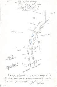
Document - Copy of Lands Department Field Notes - Township of Ringwood, Victoria, Field Notes 1913/163 - Part of O.P. R72D surveyed April 1913
... Road (Maroondah Highway), (area) Held for mining, Recreation... Road, New Lilydale Road (Maroondah Highway), (area) Held ...5612b Foolscap size photocopy of survey map with handwritten notations. References include Mines Road, New Lilydale Road (Maroondah Highway), (area) Held for mining, Recreation Reserve, Sec D, Sec E, I certify that this is a correct copy of the recorded observations & measurements made by me personally (signed) R.J. Gray 2/4/13. -
 Ringwood and District Historical Society
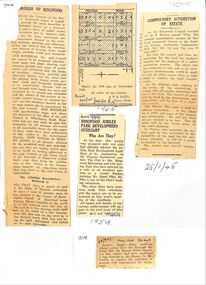
Newspaper, Newspaper articles detailing the acquisition of 40 acres of land for Jubilee Park, formerly known as Sanders Estate, for recreation purposes
Various newspaper articles about detals of the acquisition, by Ringwood Council, of 40 acres of land for Jubilee Park, formerly known as Sanders Estate, for recreation purposes in 1945-1959. The area included named streets - Prussia Road (not West Prussia Road), Duffy Street, Ireland Street, Evens Street and Chapman Street. -
 Ringwood and District Historical Society
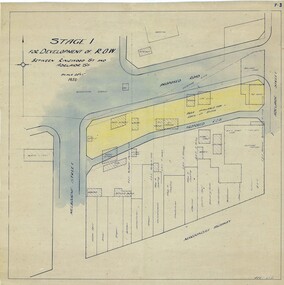
Map, Development of Right of Way Stage 1, Ringwood, Victoria - 1950
Borough Engineer's technical drawing for Development of Right of Way between Ringwood Street and Adelaide Street, Ringwood, showing existing recreation reserve, retail establishments, outbuildings, and area available for lock-up shops.Scale 20' = 1". ACR 10.7.50. (Alan Charles Robertson - Borough Engineer) -
 City of Moorabbin Historical Society (Operating the Box Cottage Museum)
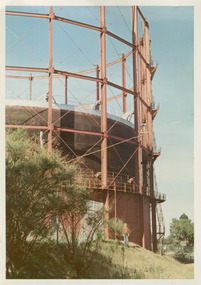
Photographs, x3 Colour,, Highett Gasworks c1974, 1974
3 of 5 photographs of the Highett Gasworks c 1974 The Brighton Gas Company was established 1877 by local residents including Thomas Bent. Initially all went well for residents as gas light replaced kerosene lamps and street lights were installed. However disruption to supply, poor quality and failure to reach all house lead to dissatisfaction. Thomas Bent therefore began the Central Brighton and Moorabbin Gas Company 1885 and a price war ensued. This was unsustainable and the two companies amalgamated in 1877 supplying gas from the New Street Works site. 1930 this Company expanded to Highett where it had purchased 45 acres adjacent to the train line. 1927 a gas holder was built connected to the Brighton works 1936 construction began on a complete gas-making unit and the Highett Gasworks, Nepean Highway, began supply 1939. 1950 an extension program was completed. However by 1965 , with the discovery of Natural Gas offshore in Bass Strait, changes to Gas distribution were apparent. At first some of the facilities at Highett were used to distribute the gas piped from Sale, Gippsland. However after conversion of 450,000 homes to Natural Gas the Highett site was redundant. The gasometers were removed 1978. Moorabbin Council obtained part of the land for public recreation purposes. ( Dr. G Whitehead KCC Historian ) c2012 the Moorabbin Justice Centre / Magistrates Court of Victoria was built and further development of the area for apartments proceeds. The establishment of the Brighton Gas Company 1877 and the Highett Gasworks 1885 brought bright lighting to houses, businesses and streets in Moorabbin Shire and cooking ovens and heating improved the living conditions of residents. 3 x Colour photographs of the Highett Gasworks c1970bass strait gas, highett gasworks, brighton gasworks 1877, central brighton and moorabbin gas company 1885, whitehead dr. graham, magistrates court of victoria, horse drawn carts, toll gates brighton, motor cars 1900, steam engines, early settlers, bentleigh, parish of moorabbin, city of moorabbin, county of bourke, moorabbin roads board, shire of moorabbin, henry dendy's special survey 1841, were j.b.; bent thomas, o'shannassy john, king richard, charman stephen, highett william, ormond francis, maynard dennis, market gardeners, vineyards, orchards -
 City of Moorabbin Historical Society (Operating the Box Cottage Museum)
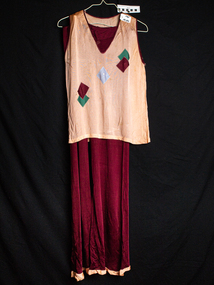
Clothing - Theatrical outfit, 2 piece for Ormond Choral Society
A 2 piece theatrical outfit, used by the Ormond Choral Society c 1950, which was formed by residents of the local area in order to provide artistic and musical entertainment and social activities for the community. Theatrical Societies were part of the community recreation for settlers in post World War 11 City of Moorabbin 2 piece Plum and peach coloured theatrical outfit consisting of a V shaped sleeveless top and loose, full length pants with elastic at waist worn by Ormond Choral Society for one of their productions ormond theatrical society, mckinnon, bentleigh, moorabbin, reed gladys, clark judy, clothing, actors, early settlers, post world war 11 estates, -
 City of Moorabbin Historical Society (Operating the Box Cottage Museum)
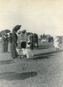
Photograph (collection) - Bentleigh Recreational Reserve, Gathering of East Bentleigh Residents, c 1915
bentleigh, city of moorabbin, bentleigh recreational reserve, william burgess, fundraising, volunteers, sportbentleigh, city of moorabbin, bentleigh recreational reserve, william burgess, fundraising, volunteers, sport -
 Bendigo Historical Society Inc.
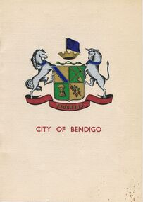
Book - JOAN O'SHEA COLLECTION: 150TH ANNIVERSARY OF BENDIGO BOOKLET, 1850 - 1950's
Joan O'Shea Collection. Buff Coloured Booklet City of Bendigo. 150th anniversary of Bendigo 1850s to 1950s. Image on cover coat of arms for City of Bendigo underneath word progress, left hand side horse, right hand side bullock. History of Bendigo: From Sheep Run to Provincial City in 100 years. Map of Bendigo and Surrounds Railways, Water Courses & Storage, Power, Municipal Boundaries & Land Available for Industry. Municipal District Creation 1855, Borough Proclamation 1863, Proclaimed City 1871, Area: 7992 Acres Population as of last census City of Bendigo 28,722, City of Bendigo and adjacent Urban Areas 36,909. City of Bendigo Map, The Past Prior to 1850. Icons of Bendigo The Bendigo base Hospital,Law Courts & Post Office, Primary Schools, Housing, Industry including Butter Production, Poultry Farming, Livestock Sales & Tomato Growing, Slaughter House & ordnance factory. The Present Recreation Photos: Bendigo Bowling Club, Queen Elizabeth Oval, Municipal Lawn Tennis Courts The Future of Bendigo, Bendigo Photographs From The 1950s,Cambridge Press Bendigobendigo, history, progress of bendigo 1850s on. -
 Port Melbourne Historical & Preservation Society
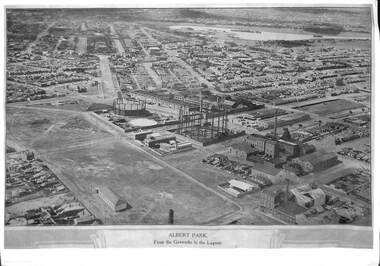
Photograph, E C Joshua, Albert Park from the Gasworks to the Lagoon, 1921
Rare copy of E C JOSHUA and Captain LARKIN work."Albert Park from the Gasworks to the Lagoon" Copy of aerial photography 1921 of former lagoon area taken by E C JOSHUA (photographer) and Captain H J LARKIN (pilot). "Views from an Aeroplane" black and white copy. Plus separate sheet giving brief description of photographtransport - aviation and aerodrome, sandridge lagoon, natural environment, recreation, built environment, parks and gardens, e c joshua, h j larkins, gasworks, schumaker mill furnishing works, pump house, sugar shed, joshua bros distillery -
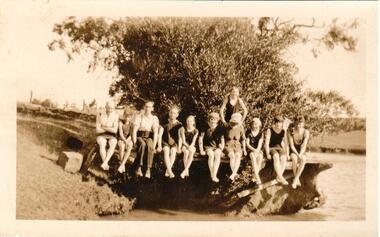
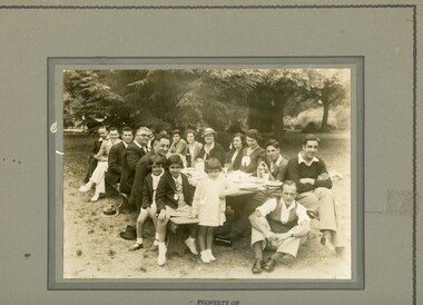 Ithacan Historical Society
Photograph, Ithacan Picnic Family Group, c 1930s
The annual picnic organised by the Ithacan Philanthropic Society has been a popular event on the club's calendar every year since its inception in 1916. It was a chance for families and friends to meet together in a relaxed atmosphere where races were also organised for all age groups. The picnics were held at recreation grounds on Melbourne's rural fringe and for many years Bacchus Marsh was a popular venue.A black and white photograph of eight men, seven ladies and three children sitting around a picnic table laid out for a meal in a large outdoor area. There are large trees in the background. -
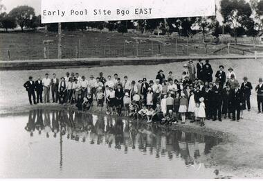 Bendigo Historical Society Inc.
Photograph - VAL CAMPBELL COLLECTION: PHOTOGRAPH OF A LARGE GROUP OF PEOPLE STANDING BESIDE A POOL
Black and white photo of a large group of people standing beside a pool which has been dug from the surrounding grassed area. The group is a mixture of adults and children. Some of the men are holding long poles and one boy a shovel. In the background sheep are grazing behind a high fence. Written on the front of the photo: Early Pool Site Bgo East. Written on the back of the photo: Bendigo East Pool the Beginning Land was donated to the Committee by Mr Moog who owned large amounts of property in the area. It was then called Moog Park then (not decipherable) then Eastern Park.recreations, sports, swimming -
 Bendigo Historical Society Inc.
Map - LONG GULLY HISTORY GROUP COLLECTION: MAP OF LONG GULLY AREA
map of Long Gjully and California Gully area from Craig Street to Barrell Street. Indicators show location of the mental hygiene Austhority, Agricultural Showgrounds and Recreation Reserve. The boundary between the Borough of Eaglehawk and Bendigo is shown by a dotted line along McGowan Street.eaglehawk, history, street map long gully/california gully. -
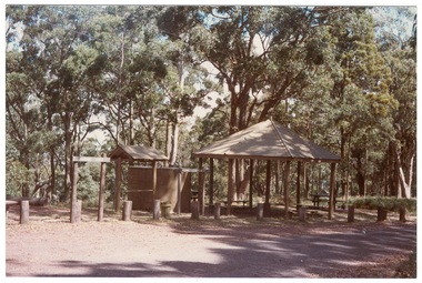 Buninyong & District Historical Society
Photograph - Colour photograph, Colour photograph of Mt. Buninyong picnic area
One of a series of photographs taken for Buninyong Shire Council 1980sMount Buninyong was reserved as a public park in 1866.Colour photograph of Mt Buninyong picnic areabuninyong shire council, mount buninyong, recreation, water tower, c.c.p. wilson -
 Hume City Civic Collection
Photograph
The area near the 'Nook' was used as a swimming pool by Sunbury residents before the swimming centre was built in Ligar Street, Sunbury. Sunbury Swimming Pool - written on the back.A snap shot of 11 people (unidentified) sitting on the bank of a river. There are two men and 9 children of varying ages in the photo.swimming, sports, jackson's creek, clothing and dress, recreation, swimming pools, sunbury swimming pool, george evans collection -
 Lakes Entrance Historical Society
Book, Land Conservation Council Victoria, The Gippsland Lakes Land Use Strategy Plan 1978, 1985
A review of public land use in the East Gippsland area, including natural resources, flora and fauna, recreation. Contains photographs, maps statistics.conservation, aboriginals, primary industry -
Lakes Entrance Historical Society
Book, Town and Country Planning Board Melbourne, Gippsland Lakes Strategy, 1978
A strategy plan to guide future development of the Gippsland Lakes in a rational manner, to benefit all residents and visitors to the area. Contains plans and mapsgovernment, community facilities, recreation -
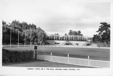 Stawell Historical Society Inc
Photograph, Central Park Oval with the grandstand. Murray Views No. 2
View of Central Park oval and grandstand before the roof was placed on No 2 grandstand in Lower Main Street Stawell. In December 1894 the area was re-gazetted as "Central Park" for recreation purposes. "Murray Views" was the photographic company that produced the postcard. c 1935Post card of Murray Views No 2 The Oval Central Park Stawell. Vic. Also 4 prints of the post card of the same image varying in size. Murray View No. 2, The Oval Central Park. Stawell. Vic is printed on the front of the post card. On the back "Real Photograph produced in Australia by Murray View, Gympie. Q.stawell sport -
Stawell Historical Society Inc
Book - Report, Grampians: A Report on recreation and Timber Uses of. Too Steep to Graze - Too Rocky to Plough, 1979
1) Conservation & Economics 2) Grampians Study Area 3) Land Use 4) Management 5) Criticisms of the Management Plan Appendix Graphs & MapsGreen Paper cover: Black tape on SpineConservation council of Victoria and Logo -
Koorie Heritage Trust
Document - Report, Birckhead, Jim, Aboriginal involvement in parks and protected areas : papers presented to a conference organised by the Johnstone Centre of Parks, Recreation and Heritage at Charles Sturt University, Albury, New South Wales 22-24 July 1991, 1992
Highlights significant differences in Aboriginal and non-Aboriginal notions of land and land management.xiv, 390 p. : ill., maps, ports. ; 27 cm.Highlights significant differences in Aboriginal and non-Aboriginal notions of land and land management.national parks and reserves -- australia -- management -- congresses. | land use -- australia -- management -- congresses. | aboriginal australians -- land tenure -- congresses. | aboriginal australians -- antiquities -- congresses. -
Whitehorse Historical Society Inc.
Pamphlet, Blackburn South Recreation Trail, 1989
Pamphlet outlining the history of the linear park along the alignment of the discontinued Healesville freeway.Pamphlet outlining the history of the linear park along the alignment of the discontinued Healesville freeway. It includes plans for the immediate future, the development of Fulton Reserve and lists the Committee of Management. A plan of the area is on the verso.Pamphlet outlining the history of the linear park along the alignment of the discontinued Healesville freeway.wurundjeri walk, fulton reserve, blackburn south recreation trail, city of nunawading -
 Whitehorse Historical Society Inc.
Document, Schwerkolt Cottage, c1985
1984/5 Budget for Schwerkolt CottageCity of Nunawading Parks and Recreation Department leaflet on Schwerkolt Cottage.non-fiction1984/5 Budget for Schwerkolt Cottageschwerkolt cottage, city of nunawading -
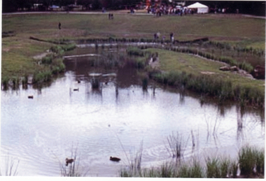 Whitehorse Historical Society Inc.
Photograph, Opening of Wurundjeri Wetlands
... lived in the area parks and reserves recreation facilities ...Wurundjeri walk, which runs alongside Fulton Road, Blackburn South, was officially opened in 1992 by Mayor, Cr. Savaas Athan, and Wurundjeri Tribal Elder, Mrs Winnie Bridges. The walk is named after the Wurundjeri tribe who once lived in the areaFive coloured photographs of the opening of the Wurundjeri Wetlands in Blackburn South in 1992. (Three photos of wetlands and 2 of crowd under umbrellas) See also ND808parks and reserves, recreation facilities, wurundjeri walk -
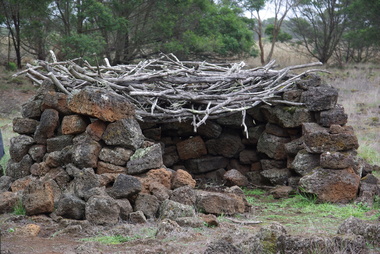 Ballarat Heritage Services
Photograph - Colour, Aboriginal Rock Hut recreations at Tyrendarra, 2016, 16/04/2016
The Budj Bim National Heritage Landscape - Tyrendarra Area on the Australian National Heritage List lies on the Tyrendarra lava flow between the Fitzroy River and Darlot Creek close to the township. The Budj Bim Cultural Landscape was ascribed on the UNESCO World Heritage List on 06 July 2019 (AEST). These photographs were taken during a guided tour with Gunditjmara guide Dennis Rose.Remains of stone shelters built and used by the Gunditj Mirring people.rock shelter, aboriginal, aborigines, tyrendarra, winda mara, rock hut, gunditjmara, unesco world heritage -
 Whitehorse Historical Society Inc.
Document, City of Nunawading Parks & Recreation Dept. 83/84, 1983
Budget 1983/84 for maintenance of Schwerkolt Cottagenon-fictionBudget 1983/84 for maintenance of Schwerkolt Cottagecity of nunawading, schwerkolt cottage -
 Hume City Civic Collection
Photograph, The Nook, c1940
The Nook in Sunbury is situated on a wide and deep bend in Jacksons Creek. Today the area is a popular site for passive recreation with a walking path along the Jacksons Creek. The house on the RHS of the photograph was situated near Powlett Street.Before the Aquatic Centre was built in Sunbury the swimming pool at The Nook was the town's swimming pool for many years. Seats and a change area were at the site.A black and white photograph of a large bend in a river with a house built on its riverbank and another dwelling on the hillside in the middle distance.the nook, swimming, jacksons creek -
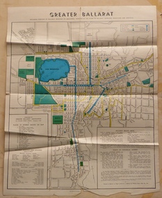
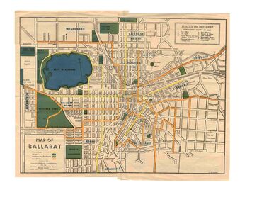 Ballarat Tramway Museum
Map, Greater Ballarat Association and George Netherway, "Map of Ballarat", c1945
Yields information about Greater Ballarat, including trams, buses, locations and streets. Has a strong association with George Netherway.Five colour map of Ballarat, showing streets, places of interest, Parks, tram routes, bus routes, railway lines, prepared by G. C. Netherway, Greater Ballarat Association, for the Victorian Government Tourist Bureau, Ballarat Branch, c1945. Shows suburbs names, location of orphanage, the lack of development north of Howitt St, in Wendouree. Map is part diagrammatic and is not entirely to scale. On rear is a road map of the Ballarat area, lists of statistics, beauty spots, look outs, art and culture, points of historical interest, industrial products and recreation. Note: Image 1, assembled from four scans, does not entirely match at edges. See Reg item 2074 for photographic image of another version map. See Reg Item 5613 for another version of this map. trams, tramways, ballarat, tram routes, bus routes, map, lists -
 Ballarat Tramway Museum
Map, Greater Ballarat Association and George Netherway, "Map of Ballarat", c1950
Yields information about Greater Ballarat, including trams, buses, locations and streets. Has a strong association with George Netherway.Four colour map of Ballarat, showing streets, places of interest, Parks, tram routes, bus routes, railway lines, prepared by G. C. Netherway, Greater Ballarat Association. Shows suburbs names, location of places of interest, some development north of Howitt St, in Wendouree. Map is part diagrammatic and is not entirely to scale. Includes the Lake Wendouree Rowing course On rear is a road map of the Ballarat area, lists of statistics, beauty spots, look outs, art and culture, points of historical interest, industrial products and recreation. Printed by Waller & Chester on paper produced by Ballarat Paper Mills Pty Ltd. See Reg item 2074 for photographic image of this version of the map. See Reg Item 2776 for another version of this map. Contained originally within Reg Item 5507 at the back of the binder. For items see btm5507 loose items list.pdf John Whiting in an email of 17-9-2021 noted: The rowing course along Lake Wendouree is noted, so perhaps this map is post 1956? The Mt Pleasant tram line is shown to terminate at Morton St, not Cobden St (which of course is incorrect) Someone's come along and drawn in black ink the branch of the View Point tram line!trams, tramways, ballarat, tram routes, bus routes, map, lists -
 Bendigo Historical Society Inc.
Document - PETER ELLIS COLLECTION: LETTER, 4th October, 1976
Letter, dated 4/10/1976 from Diana R. Collier, Hon. Secretary, The Bendigo Field Naturalists Club to The Minister for Lands, The Hon. W. A. Borthwick making an application to have a reserved area for the preservation of native flora and fauna near the Quarry Hill Golf Club. Features, fauna and flora are mentioned including an original Boundary Stone and the Fairy Waxflower (Eriostemon verrucosus) also known as the Bendigo Wax Flower. Included is a list of birds (including some that nest in the area sometimes) and plants.communication, postal, letters, peter ellis collection, the bendigo field naturalists club, proposed boyd st nature reserve, the hon w a borthwick, recreation reserve extension (rs 3458), cemetry reserve extension (rs 3777), rubbish depot (rs 5980), education purposes reserve, (rs 6402), j willis, bendigo city council, city boundary stone, regel, quarry hill golf club, canberra botanical gardens, stony ridge flora reserve sydney, kings park perth, maranoa gardens melbourne, kaweka sanctuary castlemaine, central and northern branch of the national trust, school sanctuary (quarry hill), education dept, society for growing australian plants - bendigo group, lawn cemetery, bendigo city council parks and recreation dept, bendigo trust afforestation committee, quality of life action group, ackhurst plan, winifred waddell estate, dept of crown lands and survey, ministry for conservation, mr g edwards, mr m goode, mr j chellacombe, diana r collier -
 Kew Historical Society Inc
Plan, Melbourne & Metropolitan Board of Works. Borough of Kew Detail Plan No.1579, 1904
The Melbourne and Metropolitan Board of Works (MMBW) plans were produced from the 1890s to the 1950s. They were crucial to the design and development of Melbourne's sewerage and drainage system. The plans, at a scale of 40 feet to 1 inch (1:480), provide a detailed historical record of Melbourne streetscapes and environmental features. Each plan covers one or two street blocks (roughly six streets), showing details of buildings, including garden layouts and ownership boundaries, and features such as laneways, drains, bridges, parks, municipal boundaries and other prominent landmarks as they existed at the time each plan was produced. (Source: State Library of Victoria). This plan forms part of a large group of MMBW plans and maps that was donated to the Society by the Mr Poulter, City Engineer of the City of Kew in 1989. Within this collection, thirty-five hand-coloured plans, backed with linen, are of statewide significance as they include annotations that provide details of construction materials used in buildings in the first decade of the 20th century as well as additional information about land ownership and usage. The copies in the Public Record Office Victoria and the State Library of Victoria are monochrome versions which do not denote building materials so that the maps in this collection are invaluable and unique tools for researchers and heritage consultants. A number of the plans are not held in the collection of the State Library of Victoria so they have the additional attribute of rarity.Original survey plan, issued by the MMBW to a contractor with responsibility for constructing sewers in the area identified on the plan within the Borough of Kew. The plan was at some stage hand-coloured, possibly by the contractor, but more likely by officers working in the Engineering Department of the Borough and later Town, then City of Kew. The hand-coloured sections of buildings on the plan were used to denote masonry or brick constructions (pink), weatherboard constructions (yellow), and public buildings (grey). While MMBW Plan No.1579 does not include many buildings, those that it does show are significant to Kew’s history. These include the ‘Kew [Railway] Station’ in Denmark Street and the ‘Recreation Hall’ and rear courts off Wellington Street. The plan shows the outline of the Recreation Hall, constructed in 1880, at the rear of which is listed a bowling green, two tennis courts, a ‘skittle alley’ and a pavilion. When the Hall was first built, the Kew Cricket Club occupied an adjacent ground, however in 1885 this was acquired by the State Government as the future location of the Kew Railway Station. The Plan also shows a single oval at Xavier College. This oval was completed in 1883. One of the current ovals conforms to this oval’s original shape and position in the school grounds.melbourne and metropolitan board of works, detail plans, maps - borough of kew, mmbw 1579, cartography -
 Kew Historical Society Inc
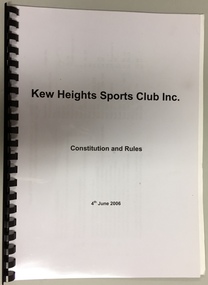
Administrative record - Document, Kew Heights Sports Club Inc: Constitution and Rules, 4th June 2006, 2006
Sports Clubs in Kew in the final decades of the 19th century and in the early 20th century were often umbrella organisations with facilities for a number of sports. Typically in Kew, this included teams in lawn bowls, tennis and croquet. The Kew Bowling Club was formed in 1880 while the privately owned Auburn Heights Recreation Club was opened in 1904. By 1998, the two Clubs decided to amalgamate at the Auburn Heights site in Barkers Road, forming the Kew Heights Sports Club. The combined club was itself taken over by the Melbourne Cricket Club in 2012 becoming MCC Kew Sports Club. In 2017 MCC Kew closed and its landholding was subsequently sold to Carey Baptist Grammar School. Both the Kew and Auburn Heights Clubs assembled important collections. These historically significant and large collections were donated to the Society in 2020. The collections include manuscripts, pictures, trophies, plans, honour boards etc. The combined collections of the four sporting clubs making up the collection number hundreds of items that are historically significant locally. They are also significant to the sporting history of the greater Melbourne area and to the sports of lawn bowls and tennis in Australia in the 19th and 20th centuries. The collection illuminates two of the Victorian historic themes - 'Building community life' through forming community organisations and 'Shaping cultural and creative life' by participating in sport and recreation.Constitution and Rules of the Kew Heights Sports Club Inc. Dated 2006.kew heights sports club - 397 barkers road - kew (vic), kew heights sports club - constitution -
 Kew Historical Society Inc
Administrative record (series), Minute Book, 2004-2006
Gift of MCC Sports Club Kew 2020AdministrationProvenance orderminutes of meetings of the kew Heights Sports Clubkew heights sports club - 397 barkers road - kew (vic), kew heights sports club - minute bookskew heights sports club - 397 barkers road - kew (vic), kew heights sports club - minute books