Showing 257 items
matching river flats
-
 Greensborough Historical Society
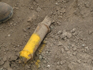
Photograph - Digital image, Dennis Ward, Axle in situ at Partington's Flat, 27/03/2010
This axle is believed to be from one of the vehicles (possibly a jinker) used by the Partington family on the Willis Vale property. It is shown after being uncovered near the Plenty River trail.From a Greensborough pioneer familyDigital copy of colour photograph.partington family, willis vale -
 Greensborough Historical Society
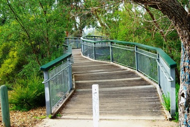
Photograph - Digital image, Marilyn Smith, Partington's Flat: footbridge over the River, 16/08/2015
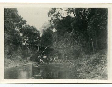
... Partington's Flat: footbridge over the River.... the footbridge over the river on the Plenty River Trail. partingtons flat ...Partington's Flat. This photo shows the footbridge over the river on the Plenty River Trail.Digital copy of colour photographspartingtons flat, plenty river trail, plenty river -
 Greensborough Historical Society
Photograph - Digital image, Marilyn Smith, Partington's Flat: River crossing / floodway, 16/08/2015
... Partington's Flat: River crossing / floodway.... the floodway / river crossing over the Plenty River. partingtons flat ...Partington's Flat. This photo shows the floodway / river crossing over the Plenty River.Digital copy of colour photographpartingtons flat, plenty river -
 Glenelg Shire Council Cultural Collection
Photograph - Sheet of 12 contact prints - Various Portland and local surrounds buildings and landmarks, c. 1970
Sheet of 12 contact prints of rephotographed photographs: Identifying numbers 5721 a, b, c, d, e, f, g, h, i, j, k, l (a) Fishing party, flat rocks Bridgewater (b) Dutton Way (c) Julia Street (d) Steam train (e) Bentinck Street corner (f) Bridge across Salt Creek 'Kingsley' in background (g) Bentinck Street railway station from Customs House (h) Yankee Doodle corner (i) Picnic on banks of river (j) Henty Bay (k) Man holding two bikes Wellington Road/Bentinck Street (l) same as (h) - Bentinck Street railway station from Customs House -
 Eltham District Historical Society Inc
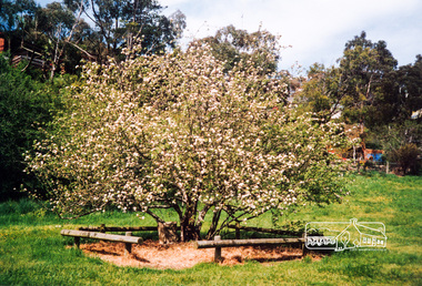
Photograph, The Batman Tree; heirloom apple tree purchased by John Batman and planted by Mr Frederick Flintoff in 1838 in the orchard of Mr Bosch, near Greensborough, now a small river flat near the Maroondah aqueduct crossing, Plenty River Walk, Greensborough, c.1989, 1989c
... orchard of Mr Bosch, near Greensborough, now a small river flat... in the orchard of Mr Bosch, near Greensborough, now a small river flat ...Colour photograph originally located in a magnetic style album titled 'Greensborough Bypass 1990s 5' suffering significant degradation. No information contained in album or on reverse of photos except where noted. Relocated to archival photosafe storage.greensborough, plenty river walk, maroondah aqueduct, batman apple tree -
 Kiewa Valley Historical Society
Photos - King Family Collection
The King family lived in Tawonga South where my older brother and sister went to school. We lived over the road from Wally Madison's farm. Later when a house became available, we moved into Valley Avenue, Mt Beauty. This is when I turned 5 and started my schooling. It was a long walk for a 5 year old as I remember. Then later we moved to 50 Lakeside Ave. I remember we loved living there as it was close to the school, footy ground and kindergarten. My father, Ted King, wad a carpenter and was involved in the building of many houses in Mt Beauty which was the home for the workers on the Kiewa Electric Scheme. So as they are part of the history of Mt Beauty I thought they may be useful to you as part of the history. The tennis photos, I vaguely remember Lou Hoad and Ken Rosewell giving exhibition matches in Mt Beauty. I may stand corrected on this, but I do remember my parents who were keen tennis players themselves were most excited at seeing these famous tennis players. As I was only 9 when we left Mt Beauty to live in Dimboola I still remember the shock of leaving a beautiful mountainous county side and arriving in a flat farming land next to a desert and seeing windmills One thing I do remember from school is, once a week (or fortnight) the teacher used to come around with a jar of little white pills, of which we were all to take. I really don't know what they were?? or for?? I also remember being taught to swim in the freezing cold river by a Mrs Smith who wore black bathers and wore her hair in a bun...... ...I am now in my 70s My father used to also carve intricate trays and jewellery boxes in his spare time. I think they were used for tennis trophies. by Diane Werner.x33 photos of small black and white photos of the Tawonga, Tawonga South and Mt Beauty - Photos not labelled but described as follows. See each photo for a possible label. A. Tawonga? B. Mt Beauty taken on the road to Bogong ? C. SEC Works D. Industrial buildings with mountains in the background E. Building site with wooden frame and 3 men F. Buildings with power poles G. Building site with lots of huts H. Buildings under construction I. Group of houses in the distance J. Group of houses in the distance K. Group of people in front of a building L. Group of 8 men sitting on timber planks, corrugated iron at back. M.& N. Building site with floor and upright timbers O. Mountain view with camp site in foreground P.& Q. Buiding site, several houses R.5 men at a building site S. portable building on trailer T & U. Mountain view V. Building site W. Group of men, car and mountains in background X. Cows Y. Pigs Z. 2 men standing next to cars. AA. Football players BB. Man painting a corrugated iron building CC. Football DD. Men in front of a building EE Buildings with mountains in background FF & GG Tennis payersHH & II. Electricity infrastructure -
 Eltham District Historical Society Inc
Photograph, Main Road, Eltham South, near Eltham Park, flooded by the Diamond Creek, 30 Nov. 1934
Near Eltham Park (now known as Eltham Lower Park), floodwaters from the Diamond Creek cut off the Main road into Eltham at Bremner’s Flats (present day Wingrove Park). In the distance, left of centre, is Mr. Montieth's Ford Wagonette stranded in the floodwater near Wingrove Cottage. “On the Lower Eltham Reserve the water was nearly five feet deep across the reserve and over a mile along the road. All the week-end shops are surrounded. For over 40 years flood waters have not reached this unprecedented level.” - Advertiser, Friday November 30, 1934, p7 "Whilst we were at the shop a "tidal" wave occured . There used to be a Mr. Monteith who ran a Model T Ford bus from the Eltham Railway Station down the main street. The bus would hold seven, six seated in the back, 3 aside a seventh standing on the step on the middle of the back hanging on to two small hand rails. The bus was caught by the flood and was abandoned not far from our shop in the paddocks towards the Higher Elementary School. It was there for days and after the flood waters receded, Mr. Monteith, after removing all the mud and debris gave the engine one turn with the handle and it started first time! So the story goes! " (Doug Orford Reminiscences, 2004) The 1934 flood of the Diamond Creek and Yarra River is the highest recorded flooding in the district and set the standard for the current planning flood plain level.Black and white photograph showing the floodwater from Diamond Creek across Main Road in 1934. Left of centre shows Mr. Montieth's Ford Wagonette in the floodwater in the distancefloods, main road, eltham south, diamond creek (creek), wingrove cottage, wingrove park, bus services, bremner's flat, eltham park, ford wagonette, mr. montieth, floodwater, reminscences -
 Eltham District Historical Society Inc
Photograph, Sweeneys Lane looking southwest, Dec 1984, 198412
... Two colour photographs of view south across Sweeneys flats... melbourne sweeneys lane yarra river eltham thomas sweeney culla hill ...Two colour photographs of view south across Sweeneys flats and Yarra River, Sweeneys Lane, Elthamsweeneys lane, yarra river, eltham, thomas sweeney, culla hill -
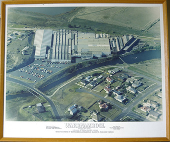 Warrnambool and District Historical Society Inc.
Photograph - Framed aerial photograph of Warrnambool Woollen Mill, Circa 1970
In 1869, the Warrnambool Meat Preserving Company commenced their business on the site, where it operated until 1875 when it was sold to the directors of the Warrnambool Woollen Mill Company. After being destroyed by fire in 1882 it wasn’t until 1910 that the Warrnambool Chamber of Commerce was approached by Marcus Saltau and Peter McGennan to invest in a new mill. The original directors were James Dickson, P J McGennan, Robert Swinton, M Saltau, and J W Younger. In 1955 the Warrnambool Woollen Mill formed a partnership with the Wangaratta Woollen Mills. Dunlop bought the mill in 1968. From that time until its closure in 2000 it had a number of different owners, the last being the Smith Family Industries. The Mill site holds significance for Warrnambool as the site was one of the earliest industries established in the town. The Warrnambool Woollen Mill operated for close to 100 years and in that time forged a strong link with the people of Warrnambool. Its product held a significant position in the marketplace.Aerial colour photograph of the Warrnambool Woollen Mill and surrounding area including carparks. The Merri River crosses from lower left to upper right. Playing field, Jetty Flat, in upper right hand corner and Harris Street bridge in lower left. Aspect is looking easterly. Photo glued to white card mount with text in black underneath. Timber frameWarrnambool Woollen Mill A division of Dunlop Olympic Limited. Manufacturers of Warrnambool/Dreamspun blankets, rugs and fabrics. Registered office South Warrnambool, Victoria. 3280. Australia. P.O. Box 484 Telephone (055)624166. Telex 55820warrnambool, warrnambool woollen mill, woollen mill, dunlop olympic, marcus saltau, p j mcgennan, james dickson, robert swinton, j w younger, dreamspun -
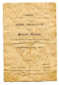 Orbost & District Historical Society
advertisement, 1902
Mrs Arthurena Dora Beattie (nee Morrison), had been teaching privately at Rosedale and came to Orbost with her husband and family in 1890. In 1892 she opened a private school in Salisbury Street (about the site of the Countryman Motor Inn) which she conducted for about 10 to 12 years. Her husband, John Wilson Beattie, a retired State School teacher, had been head teacher at the Rosedale School from July 1870 to August 1884. After coming to Orbost he selected land on Wall Creek. He was a widower with 7 of 11 surviving children when he married Arthurena in 1885. His fist wife, Georgina (nee KELLY) died at Rosedale in 1883 when the youngest child was just 5 weeks old. John and Arthurena had a further 8 children (5 born at Orbost), and after John's death she married George McCARLIE in 1916 at Sale and moved Mirboo North. (references:BEATTIE, Arthurena Dora Music teacher, Orbost - 1903 Electoral Roll. BEATTIE, Arthurena Dora Teacher, Orbost - 1912 Electoral Roll.) There was at least one other private school much earlier, in 1884. It was thought to be the first school in the district and conducted by William Ballantyne. It was located on the flat on the Newmerella side of the Snowy River near where the first railway crossing used to be. Wm Ballantyne had previously taught school at Sarsfield from June 1873 to November 1879. (information from John Phillips) This advertisement was for educational tuition by Mrs Beattie. Tuition would be from 10.00am - 12.00 and from 1.30pm - 3.30pm. Costs were thirteen shillings per quarter for children under the age of 12 years and one guinea for those over 12 years. A reduction would be given for more than one child in the same family. The 1872 legislation required all children aged 6-15 years to attend school unless they had a reasonable excuse. Parents who did not send their children to school were liable for fines up to five shillings for a first offence, with the penalty increasing to 20 shillings for each repeat offence. The Orbost State School had opened on 19th of March 1886 and this "private school" appears to have been a small private enterprise school. This is a useful research item associated with education in Orbost.A white A5 size paper advertisement which has black print. It is an advertisement for private educational tuition. Details of costs and hours are included.beattie education school advertising -
 Orbost & District Historical Society
newspaper clippings, February 1971
These articles were compiled by Mary Gilbert who was the first curator of the Orbost Museum and a prominent historian / teacher in Orbost. The 1971 floods at Orbost were the worst on record. At Jarrahmond the river rose to a height of 11 metres and on the flats spread to one and a half kilometres wide. Considerable damage was done to railway infrastructure, roads and farms. More information from the APRIL, 2008 newsletter by John Phillips. (see orbosthistory.com.au)These articles are contemporary records of a significant historical event in Orbost.A manila folder containing black / white newspaper clippings from various publishers. They all relate to the 1971 floods in Orbost. (Details of contents in catalogue 735-900)floods-orbost-1971 -
 Orbost & District Historical Society
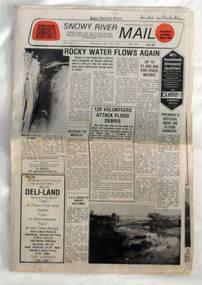
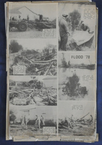
newspaper, Snowy River Mail, June 14 1978
Orbost has been subject to major floods throughout its history, such as those which left the town isolated in 1934, 1952, 1971 and 1978. It is recorded that the Snowy River broke its banks and flooded the flats 104 times between 1884 and 1978. Extensive flooding in Eastern Victoria during June 1978, caused widespread damage to roads, road closures and hazards to traffic, particularly over the Queen's Birthday holiday weekend.Since 1890 the Snowy River Mail has been the local newspaper of the Orbost district.This local paper has been the means by which readers in Orbost were able to learn about newsworthy events and issues in their local community for over a century. This paper is a contemporary record of a significant event in Orbost's history of flooding.A newspaper, Snowy River Mail, which contains black / white photographs of the 1978 floods in Orbost.orbost-floods-1978 -
 Orbost & District Historical Society
Decorative object - Brooch
These items are from the Temple estate. George Temple (1832-1916) started Temple's store opposite Orbost Post Office. Packed stores to Bendoc area gold fields, also had a store in Cann River. This item is an example of a popular piece of jewelry worn by women in the early 20th century. These brooches were sold in a local store and could have been purchased for a local funeral.Black, bakelite brooch - three small sections form centre of brooch, one is a hexagonal cone-shape with hexagonal dome attached by link to smaller circular polygon attached by link to a smaller flat pentagon. Black mesh in the shape of wings form the backing featuring eight bakelite stars of varying sizes (two smaller stars missing from the assembly). A metal pin is attached to the rear in the form of a clasp.1900s jewellery, bakelite, mourning brooch, george temple, orbost store -
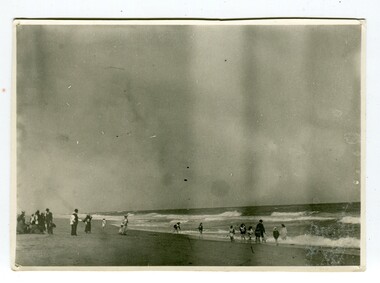 Orbost & District Historical Society
black and white photograph, January 1901
This photograph was taken at the "old station" at Corringle near Orbost. It was a popular picnic spot. Late in 1857 Mr Thomas T. Stirling took over Corringle Run ("Corringle" means "shallow water"). Mr Stirling and his family came from the wester district - Winchelsea. He settled at the Old Station. A few people were employed at the Orbost Stationb and there was settlement on the Orbost flats, Mr T. T. Stirling held the land from Lake Tyrers to Bemm River as a cattle run. About 1888 he became Secretary of the new Tambo Shire.This is a contemporary pictorial record of rural family life in Orbost in the early 20th century.A black / white photograph showing people on a beach with some in the water. those on the sand are dressed formally - men wearing suits and hats, the ladies in long dresses and hats.on back - "Picnic at OLD STATION Jan 1901"orbost-station orbost-family-life recreation -
 Orbost & District Historical Society
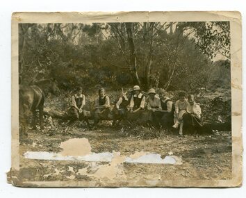
black and white photograph, 1923
This photograph was taken at the "old station" at Corringle near Orbost. It was a popular picnic spot. Late in 1857 Mr Thomas T. Stirling took over Corringle Run ("Corringle" means "shallow water"). Mr Stirling and his family came from the wester district - Winchelsea. He settled at the Old Station. A few people were employed at the Orbost Stationb and there was settlement on the Orbost flats, Mr T. T. Stirling held the land from Lake Tyrers to Bemm River as a cattle run. About 1888 he became Secretary of the new Tambo Shire. In the photograph L-R are; Hilda Kerr; Myra Malcolm; Marion Nixon; Bess Goudie (teacher); Mary Gilbert; Gwen Hobson (teacher); Pen GilbertOrbost High School / Orbost Secondary College has played a significant part in the education of senior students in the Orbost district . It is the sole senior educational institution. This item is representative of its history. It is a useful reference tool.A black / white photograph of a group of young women sitting on a log in a clearing in a bush setting. Five are in school uniform. On the left is a horseeducation-orbost orbost-higher-elementary-school recreation old-station-corringle -
 Orbost & District Historical Society
black and white photographs, 1890s
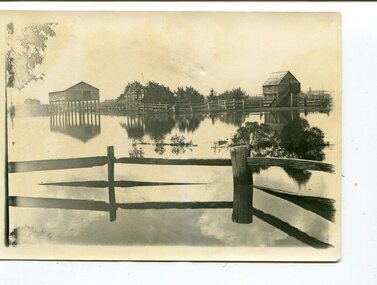
Peter Cameron, came to Orbost in 1885, at the age of 69, having sold his farm at Geelong. Peter bought the property ―Glen Avon from a Mr Street. The home was situated at the bottom of the paddock, near the corner of Morley and Livingstone streets. The farm stretched from Tennyson Street to the end of Snaggers Lane and along the river frontage to “Carinya” Cameron Home. In the Gippsland Times on Wednesday. 2 Jul 1890 on Page 3 is an article titled "THE SNOWY RIVER CALAMITY" which describes an ".unexpectedly sudden rush of water down the flats..... the terrified people commenced to remove their stock from the land and the work of saving property was continued all day ............ many head of cattle were washed away.......The river road, for its entire length, is obliterated, and the approaches to the bridge at Watt's Gulch are gone, with the enormous volume of flood water," These photographs are pictorial records of a significant event in the history of Orbost. There are few personal records of the very early floods.Three black / white photographs of wooden buildings with flood water in foreground. There are post and rail fences. 3193.2 has been taken from a distance.on back -" "Glenavon east of Lagoon 1897 Feb"floods-orbost-1890s glenavon-orbost -
 Orbost & District Historical Society
black and white photograph, February 1971
This photograph was taken near the Snowy River Bridge on the the old Princes Highway in Orbost, near the caravan park. The 1971 flood was the the worst flood on record. At Jarrahmond it was at least 11 metres and up to one and a half kilometres wide on the flats causing enormous damage to the flood plain. Records say that "The brown floodwater stain in Bass Strait could be seen from passing airliners." Considerable damage was done to railway infrastructure, roads and farms. More information from the APRIL, 2008 newsletter by John Phillips. (see orbosthistory.com.au)This is pictorial evidence of a significant local event. Floods have been an integral part of Orbost's history for hundreds of years.A black / white photograph of debris, fallen power lines, a tree across the highway and floodwaters across the road.on front at bottom - handwritten in upper case print - " 1971 FLOOD PRINCES HIGHWAY NEAR SNOWY BRIDGE"floods-orbost-1971 -
 Orbost & District Historical Society
Photograph, 1930s
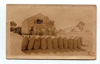
Maize has been grown on the Orbost flats for at least 70 years. When early settlers began to arrive on the Snowy River somewhere in the 1880s, the land was mostly swamps and heavily timbered jungle on the river frontages. The swamps were drained, bit by bit, with short handled shovels working in mud and water. The frontages were cleared by axe and shovel and fire. Several kinds of crops were experimented with such as hops, hemp and maize which grew particularly well and became the main crop of district. The problem then was to thresh and deliver the product to the market. A small single cob machine was brought here and one man turned the handle, while the boy or Mum fed the cobs singly into the machine. A good day’s work would thresh about 50 bushels or about 12 bags (4 bushels). The task then was to cart the maize to market. For a few years this was done by horses and dray carrying about 60 bushels to Mossiface, where it was loaded onto river boats to Lakes Entrance, and then by ocean boats to Melbourne. (information from NEWSLETTER OCTOBER, 2006)The growing of maize in the Orbost district contributed significantly to the economy of the township for many years, The many maize cribs once seen on the surrounding farms have now disappeared and this photograph is a pictorial record of that significance.A small sepia photograph with six men in front of a wooden barn. They are bagging maize. In the foreground are two rows of filled bags. On the right is a lifting machine to take the bags to the top storey. On the far right is a water tank on a stand"on back - "Thrashing Maize"maize-orbost agriculture-maize industry -
 Orbost & District Historical Society
black and white photograph, C1890
This snagging team is on the Brodribb River, east of Orbost. The Brodribb bridge can be seen in the background of the Photograph. The Snowy River was used for commercial navigation after 1880 and extensive de-snagging A shipping company was formed in 1880, poling barges upstream until the removal of large trees and branches that had fallen into the river was carried out to make the river upstream of Marlo easier to navigate. "The snaggers played an important part in making the river free for transport. By 1880 Captain Collins, R McNair engineer, J McNair and the two Winchesters were at work with a punt on the Snowy and Brodribb. Mr. Jim Winchester took charge soon after. Early snaggers were Johnston, J Renton, Nat Lynch, John Drew, Hatton, J Scott and Harry Wilkinson. The system used was to use a tree on the river bank as a lever and with heavy manila ropes, slowly to haul the snags out. They were piled up around a tree and burned when dry. The snaggers lived in a row of cottages in Snaggers’ Lane." (info. John Phillips Newsletter March 2004)The snaggers played an important role in the early settlement of the Orbost / Marlo district helping bto open it up to commercial shipping.Two copies of a black / white photograph of nine men on a snagging boat, a flat-bottom barge. In the background is a bridge.on back - "Snagging boat on Brodribb with R.McNair"snaggers-brodribb-river snagging-east-gippsland transportation -
 Orbost & District Historical Society
black and white photograph, October 4 1978
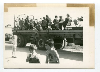
From the Snowy River Mail October 4 1978 page 9 - " A MOBILE BAND - Although Orbost Municipal Band participated in Saturday's Primary School workathon, members feet didn't touch the ground. They idi it bthe easywayon the trailer of a truck. The band encouraged walkers with stirring music along the road to Marlo." The first Orbost Brass Band was formed in 1889. Around 1908 the town band split and the Orbost Workers' Band was formed. Eventually the two bands merged in 1913 to reform as the Orbost Municipal Band under conductorship of Charles Spink. The band continued for many years but was later disbanded and again reformed. This was to happen a number of times, the last time being in 1961 and continuing through to the late 1970's. Further info and Ref: In Times Gone By - Deborah Hall This is a pictorial record of the Orbost Municipal Band. The various Orbost bands over the years played a major role in community activities providing entertainment and musical experiences for the many members.A black / white photograph showing a group of uniformed band members sitting on folding chair s on the tray of a large flat bed truck. They are holding musical instruments. A young boy is sitting on the edge of the tray and three other children are standing on the road nearby.on back - information from S.R.M.music orbost-municipal-band entertainment recreation -
 Orbost & District Historical Society
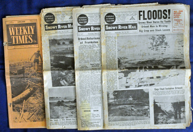
newspapers, February, March 1971
The 1971 flood was the the worst flood on record. At Jarrahmond it was at least 11 metres and up to one and a half kilometres wide on the flats causing enormous damage to the flood plain. Records say that "The brown floodwater stain in Bass Strait could be seen from passing airliners." Considerable damage was done to railway infrastructure, roads and farms. More information from the APRIL, 2008 newsletter by John Phillips. (see orbosthistory.com.au) These newspapers are contemporary records of a significant local event.Four newspapers relating to the floods in 1971. They contain news articles and photographs of the floods in Orbost in early 1971. 2556.1 is the Weekly Times dated 3.3.1971 and has an orange cover. 2556.2 is a Snowy River Mail dated 17.2.1971. 2556.3 is a Snowy River Mail dated 10.2.1971. 2556.4 is a Snowy River Mail dated 3.3.1971.floods-orbost-1971 snowy-river-mail weekly-times newspapers -
 Orbost & District Historical Society
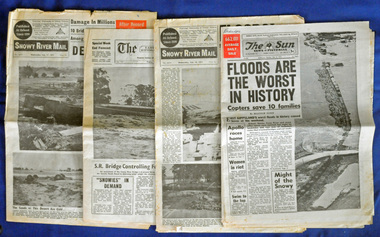
newspapers, February 1971
The 1971 floods at Orbost were the worst on record. At Jarrahmond the river rose to a height of 11 metres and on the flats spread to one and a half kilometres wide. Considerable damage was done to railway infrastructure, roads and farms. More information from the APRIL, 2008 newsletter by John Phillips. (see orbosthistory.com.au)These newspapers are contemporary records of a significant local event.Four newspapers and a set of clippings from various papers. They contain information and photographs pertaining to the 1971 floods in Orbost. 2557.1 is a Sun News Pictorial dated 8.2.1971. 2557.2 is a Snowy River Mail dated 10.2.1971. 2557.3 is an east Gippsland News dated 12.2.1971. 2557.4 is a Snowy River mail dated 12.2.1971 and 2557.5 is a collection of various clippings.floods-orbost-1971 newspaper snowy-river-mail sun-news-pictorial -
 Orbost & District Historical Society
newspaper clippings, June 1978
Orbost has been subject to major floods throughout its history, such as those which left the town isolated in 1934, 1952, 1971 and 1978. It is recorded that the Snowy River broke its banks and flooded the flats 104 times between 1884 and 1978. Extensive flooding in Eastern Victoria during June 1978, caused widespread damage to roads, road closures and hazards to traffic, particularly over the Queen's Birthday holiday weekend. These newspaper articles are contemporary records of a significant event in Orbost history.A collection of black/white newspaper clippings relating to the 1978 flood in Orbost. Some are original articles. others are photo-copies. They appear to be from the Snowy River Mail newspaper.floods-orbost-1978 newspaper-articles -
 Orbost & District Historical Society
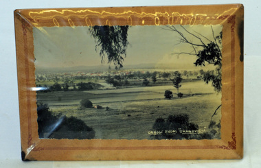
framed photograph, Orbost From "Grandview", mid 20th century
... in plastic. The photograph is of the Orbost flats with the river... the Orbost flats. Grandview Orbost-flats photograph in white ...This photograph was taken from Grandview overlooking the Orbost flats.A black/white photograph in a frame. The frame has a stand. The frame is card padded over a metal frame. It is covered in plastic. The photograph is of the Orbost flats with the river and the town in the background.in white - "Orbost From "Grandview"grandview orbost-flats photograph -
 Glen Eira Historical Society
Article - ‘REPTON’, ELM AVENUE, 10, ELSTERNWICK
This file contains six items about this mansion: 1/Three pages of handwritten notes by Peta Darke, dated December 2013, concerning the title and ownership of Repton from 1881 till 2013, earlier called ‘Wahgunyah’ 2/Handwritten list of owners of Repton from various editions of Sands and McDougall Directories compiled by Peta Darke on 06/12/2013 3/Black-and-white photograph of exterior of Repton, undated, photographer unknown 4/Seven copies each of a classified advertisement in The Argus newspaper relating to Repton and its occupiers. Dates are 15/01/1927, 15/12/1928, 07/03/1917, 10/07/1926, 02/07/1940, 10/04/1944, and 28/01/1949 5/Article in Property Review Weekly dated 15/11/2013 advertising forthcoming auction on 30/11/2013. Includes colour photographs of exterior and interior. Also brochure real estate agent advertising forthcoming auction of Repton: includes 4 colour photographs of exterior and interior, description of property and plan of layout. Produced in 2013. 6/Printed information taken from 'Trove' regarding former residents of 'Repton', Elm Street, Elsternwick by Claire Barton. Research is from the Stubss family tree about Dermot Du Moulin Ryan whose mother's address is listed as this property.repton, wahgunyah, elm avenue, elm road, elsternwick, roan andrew, partridge john douglas, partridge alice anna, partridge john roland phelps, phillips ida mary charlotte, steers reuben rivers, mann agnes, gruer william frank, taylor james alexander, marmaras george, marmaras arthur, supported housing, stevens edward, matthews herbert, repton court flats, marmara drive, lehte, fosbery avenue, taylor florence ethel, wood john frances wealth, brick houses, land subdivision, flats, victorian style, stubbs family, ryan dermot du moulin, ryan kate, elm street, house names, ryan h h -
 Bright & District Historical Society operating the Bright Museum
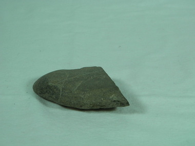
Axe Stone
Presence of Aboriginal people and their activities in Buffalo RiverAboriginal axes are relatively uncommon in North East Victoria and provide evidence of presence and exploitation of resourcesground edge stone axe with some edge damage and edge polish on working edge and flat opposite edge. axe, aboriginal artefact, buffalo river -
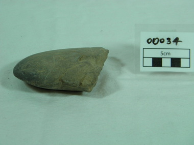 Bright & District Historical Society operating the Bright Museum
Axe Stone
Collected by Charles Willoughby on his farm on the site of the current Lake Buffaloregional significance as ground edge stone axes are relatively rare in North Eastern Regionedge ground stone axe, quartzite,flat backed and evidence of hafting axe, aboriginal artefact, buffalo river -
 Federation University Historical Collection
Document - Booklets, Books of sheet music, Mid 1900s
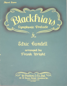
Frank Wright was a renown resident of Smeaton, where he was born on 2 August 1901. He lived at Laura Villa, and attended Smeaton State School. His father William was a gold miner and his mother's name was Sarah. Their family won many singing and instrumental awards. Frank was tutored by Percy Code and was awarded a gold medal for the highest marks in the ALCM examinations in the British Colonies at the age of seventeen years. He became the Australian Open Cornet Champion by the age of eighteen. A year later, Frank conducted the City of Ballarat Band, and later the Ballarat Soldiers’ Memorial Band. He formed the Frank Wright Frisco Band and Frank Wright and his Coliseum Orchestra. These bands won many South Street awards, and Frank as conductor won many awards in the Australian Band Championship contest. In 1933 Frank Wright sailed to England to conduct the famous St Hilda’s Band and was later appointed Musical Director of the London County Council, where he organized many amazing concerts in parks, in and around the London district. He was made Professor of Brass and Military Band Scoring and conducted at the Guildhall of Music and Drama. Frank was often invited to adjudicate Brass Band Championships around Europe, in Australia, including South Street and in New Zealand. The Frank Wright Medal at the Royal South Street competition is awarded to an individual recognized as making an outstanding contribution to brass music in Australia.11 books of sheet music written by various composers but all arranged by Frank Wright. 1). 'Le Carnaval Romain' (The Roman Carnival) Overture by Berlioz for Solo B flat Cornet (Conductor). 2). 'Ida and Dot' Polka by F.H.Losey, for Soprano Cornet, 1st & 2nd Solo Cornet (Conductor), 3rd Cornet, Repiano B flat, 2nd Cornet, Solo Tenore E flat, 1st Tenor E flat, 2nd Tenor E flat, Euphonium B flat, Bass Trombone, 1st Baritone B flat, 2nd Baritone B flat, 1st Trombone, 2nd Trombone, Contre Bass E flat & Drums. The Pianoforte accompaniment was arranged by Frank Wright. 3). 'Trumpet Concerto' by Haydn. The Full Score with parts for a band of 25. 4). 'Diadem of Gold' Overture by G.Bailey for Solo B flat Cornet (Conductor). 5). 'The Frogs (of Aristophanes)' Overture for Solo B flat Cornet (Conductor), Short Score & Full Score arranged for brass band. 6). Variations of 'The Shining River' by Edmund Rubbra for Solo B flat Cornet (Conductor). 7). 'Le Roi D'Ys' (The King of Ys) Overture by Edouard Lalo for Solo B flat Cornet (Conductor). 8). 'Sovereign Heritage' Symphonic Overture by J.Beaver for Solo B flat Cornet (Conductor). 9). 'La Forza del Destino' (The Force of Destiny) Overture by Verdi - the Short Score. 10). 'Blackfriars' Symphonic Prelude by Edric Cundell - Short Score. 11). 'Diadem of Gold' Overture by G.Bailey - Short Score1). Pencil markings on page 1,4,5 &6. 9). Written in pen on front cover - Mr Geoffrey Hosier. 10). Written in pen on title page - All good wishes F.W. 29.x.'55frank wright, sheet music, le carnaval romain, berlioz, ida and dot polka, f.h. losey, trumpet concerto, haydn, diadem of gold overture, g. bailey, the frogs overture, granville bantock, the shining river, edmund rubbra, le roi d'ys overture, edouard lalo, sovereign heritage, j. beaver, la forza del destino overture, verdi, cornet, blackfriars symphonic prelude, eric cundell -
 Federation University Historical Collection
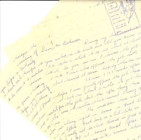
Correspondence, Letter from Lance Matthews concerning the Snowy Mountains Scheme, 1958, 25/11/1958
Lance Matthews was a former student of the Ballarat School of Mines. Dick Richards was the Principal Construction of the Snowy Scheme was managed by the Snowy Mountains Hydroelectric Authority, it officially began on 17 October 1949 and took 25 years, officially completed on 21 October 1972.A letter comprising of three handwritten pages discussing experiences of work with the Snowy River Authority by Lance Mattews. The letter was written to Richard W. Richards, Principal of the Ballarat School of Mines. A forth page is a response to the letter by Dick Richards. In the letter Matthew relates that he is living at Cooma in the East Camp, and compares the living condition to an army camp. Matthew was working for contractors, Kaiser Walsh, at the Base Plant Pool at Polo Flat about 2 miles out of Cooma. He was involved in a two week tour (inventory) of the Snowy River Scheme and saw most part of the project including Adaminaby Dam, Tunnel Pond, T1 power station and the sites and initial stages of Tooma Reservoir, Lobs Hole Reservoir, Jindabyne Reservoir and several access tunnels..dick richards, lance matthews -
Federation University Historical Collection
Document - Reports, Martin Westbrooke, Nanya Station
Nanya Station, owned and managed by the University of Ballarat (now Federation University Australia), was purchased with assistance from the Department of Environment and Heritage Government Caring for our Country program. Nanya Station is located in the Scotia country, west of the Darling Ana-Branch in far western New South Wales and consists of the Nanya Western Lands Pastoral Lease 3281 – Perpetual Leasehold Lot 1244 in Deposited Plan 762778, Parish of Winnebaga, County of Tara and part of Lot 1242 County of Windeyer. Nanya is within the tribal area of the Danggali Aboriginal people, a sub-group of the Barkindji. Many Aboriginal sites have been recorded adjacent to major rivers in the region providing evidence that these areas supported a large population. The Scotia region has one of the shortest stock grazing histories of western NSW. Along with five other Scotia properties, Nanya was created as a pastoral lease in 1927. The first European settlement on the land followed exploration of the area by Sturt and Eyre. In 1854, the Lake Victoria lease which encompassed this area comprised 465,000ha.included Scotia blocks 1, 2, 3 and 4, Amoskeag and Winnebaga which formed the area known as the Scotia. It was described as a region of thick mallee scrub, interspersed with bluebush flats and Belah woodland. In the 1920s artesian water was found and the dry Scotia country was surveyed and divided into six Homestead leases allocated by ballot (Withers 1989). All properties were approximately 30,000ha, with a recommended stocking level of 3,000 sheep. Winnebaga (renamed Nanya) was taken up by Gordon Cumming. He initially dug a dam near the southeast corner of the property. A larger ground tank and rudimentary dwelling at the site of the present complex was later established. An adjacent area was cleared and cropped to provide feed for the horses used in digging the earth tanks. The ruins of the original building are located between the shearing shed and Homestead Tank. A cottage was built in the 1930s and a more substantial Red Gum framed homestead in the early 1950s. The lease was held by Mr Gordon Cumming until 1984 when it was purchased by Mr Norm Scadding as an extension to the adjacent lease, Belvedere. It was sold in 1995 to Mr Rob Taylor of Waikerie then in 1999 to BeMax Pty. Ltd., a sand mining company. These last three owners all permitted use of the property by the University for teaching and research. The Centre for Environmental Management at the University of Ballarat had been involved in studies of flora and fauna in western New South Wales since 1988. Studies became concentrated on the Scotia region with its variety of intact ecosystems due to a short pastoral history. Of particular significance is a system of natural salt lakes of which the most extensive is the Scotia Discharge Complex located on Nanya Station. An extensive vegetation survey of the Scotia region Westbrooke et al. 1998) highlighted the significance of the area both in terms of the range of communities in relatively intact condition and the occurrence of species and communities of restricted distribution. Nearly 400 species were recorded of which nine had either not previously been recorded or have restricted distribution in western NSW. Twenty-two plant communities occur on Nanya Station of which two, Halosarcia lylei low open shrubland and Hemichroa diandra/Halosarcia/Frankenia low open shrubland, are dominated by species not previously recorded from NSW. H. lylei and Acacia loderi shrublands are listed as endangered under the NSW Threatened Species Conservation Act. As noted, the area has a relatively short grazing history and, due to the presence of large areas of mallee with a Triodia understorey and restricted water supplies, stocking rates have been low. The diversity of ecosystems in relatively intact condition and extensive areas of old growth mallee made Nanya a highly significant refuge for biological diversity. This factors led to the purchase of Nanya Station by the University of Ballarat in 2004 with the assistance of the Department of Environment and Heritage for the purposes of conservation, research and education. In 2010 the southern paddocks of Nagaella Station (10,000ha.) which lie along the northern boundary, were purchased with the assistance of Lower Murray Darling Catchment Management Authority and added to the Nanya lease to provide complete protection for the communities of the Nanya Discharge Complex and further high quality Malleefowl habitat. Four digital reports documents relating to Federation University's Nanya Station, Western New South Walesnanya station, scotia country, pastoral lease, winnebaga county, darling ana-branch, martin westbrooke, environmental education, nagaella station, lower murray darling catchment management authority, conservation research education, ian gribble, pat prevett, ian henderson, danggali