Showing 510 items
matching settlement in victoria
-
 Federation University Historical Collection
Book, Victoria Education Gazette and Teachers' Aid, 1921-1930, 1921-1930
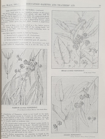
The Victoria Education Gazette and Teachers' Aid was published for Victoria's teachers and was sent to all school on the state. In 1920 The Ballarat School of Mines had donated 136 pounds 14 shillings and 10 pence to the Victorian Education Department's War Relief Account, and the Ballarat Junior Technical School had donated 10 pounds 6 shillings and 10 pence.Ten black hard covered volumes with red tape spine, covering 1921 to 1930. The gazettes include Education Department appointments, transfers, resignations and retirements, vacancies, notices, queries, notices of books, examination papers, original articles, lesson plans, suggestions for lessons, drawing, obituaries, notes on nature study, mathematics, music, sloyd woodwork, English grammar, Victorian State School Swimming Clubs, Geography, penmanship, science, History, Latin, Geography, The School Garden, horticulture, singing, World War One; ANZAC Day, lifesaving, Astronomy, Empire Day, ANZAC Buffet London, Victorian Education Department's War Relief Fund .1) 1928. Articles include: New Caledonia, Swimming and Lifesaving, School forestry, a visit to the pyramids, Exploration of Gippsland, paul de Strezelecki, Angus McMillan, Villers Bretonneux Memorial School, American Black Walnut, Red Gum, Messmate Stringybark, The Great Barrier Reef, retirement of Frank Tate, Stawell High School, Report on Some Aspects of Education in the United States, Jubilee Education Exhibition , New School Readers; measured Drawing Images include: Macarthur Street School's Plantation, Maryborough School Plantation, Pinus Insignis (Radiata) ready for Milling, Creswick State Forest, Metalwork, Daylesford Pine Plantation four years old, Henry Harvey (art Inspector); Omeo School Endowment Plantation; Frank Tate; Stawell High School Drawings From Casts; Lake Tyers School Endowment Plantation, measured drawing, Thomas H. Stuart, GEorge Swinburne. J.R. Tantham-Fryer, Cookery Class, John Edward Thomas. .3) War Savings Stampsm Swimming and Life-saving, Teh Rural School System of Victoria, Imaginative Composition, ANZAC Day, Retardation, Teh Bright Child Hudson Hard Obituary, Leeches, Relief for Distress in Europe, Dental, Teachers' Library, History of Portarlington, J.E. Stevens Obituary, Victorian Teachers in England Images: Swimming and Life-Saving Medallion .3) Swimming and Lifesaving, Bronze medallion, Victoria Leage of Victori, War Savings Stamps, Rural School Sytem of Victoria, .4) War Relief, Talbot Colony for Epileptics Masonmeadows, Discipline New and Old (Percy Samson), Soldier teachers, Preservation of Australian Birds, Arbor Day, Jubilee of Free Education, Teaching Geography, Poery in Schools, School Committees, Shelter Pavilion, Mysia Memorial School, Clovers, Jubilee Exhibition, Domestic Arts, Louis Pasteur, .5) Victoria League of Victoria, An Endowment Scheme (Pine Plantations), School Endowment Plantations, Protecting our trees by Owen Jones,. Victorian State Schools Horticultural Society, Sloyd Woodwork, School Forestry, Thomas Brodribb Obituary and portrait, Imperial Education Conference London, school Management and Method, School plantations, Eucalypt plantations in the Bendix and Heathcote District, Junior Red Cross, Jubilee Education Exhibition, Gould League Competitions, handwriting, The School Magazine, Frank Tate in London, Victorian beetles, Council of Public Education, Villers Bretonneux and its new School, Death of Samuel Summons, Woodwork Summer School, Swimming, Japanese Relief Fund, Retirement of John Cross, reminiscences of the Late Mr Albert Mattingley .6) Thomas H. Trengrove and the Villers Bretonneux School hall and pilaster carvings, forestry, visit of Maryborough teachers to Ballarat Water Reserves, noxious weeds, relief for Distressed Europe, The Dalton Plan, Empire Day, Retirement of Mr Fussell, Centenary of Hume and Hovell Expedition, League of Kindness, Effective Nature Study in a Rural School, Some Facts About Paper and their Bearing Upon School Plantations, Council of the Working Men's College Melbourne, Maria Montessori, University Vacation School, Horticulture in State Schools, An Informal Chat About French Schools (C.R. McRae), The Vacation School, Johann Heinrich Pestalozzi, Inspector's Report on a 5th-class School, Can Children Write Verse, John Adams, Victoria League of Victoria, R.F. Toutcher, Sir James Barbie's Address to High-School Girls, Impressions of a High School Teacher Abroad (R.D. Collman), The Spirit of the School Plantation Scheme, Monument of the Late Mr and Mrs A.T. Sharp at Box Hill Cemetery, The Teaching of Geography, The Treatment of Poetry in Class, Two Difficult Arithmetic Lessons, Location of Principal Australian Timbers, Dr John Smyth, Stammering and its Influence on Education, Wireless Broadcasting as an Educational Medium, Boys School at Villers Brettonneux, The New School at Villers Brettonneux, Bird Day, Messmate or Stringybark, What Every Woman Knows, Director's Report on Denmark .7)1925 . Includes: School Forestry, horticulture, J.H. Betheras retirement, Ivanhoe School, Coburg School, Moorabool Junior Technical School, Villers Bretonneux School hall and pilaster carvings, Francis Ormond, William Charles Kernot, Corsican Pnes at Creswick, Ballarat High School Plantation, Workin Men's College, RMIT, Naorrow LEafed Peppermint, Education and World Peace, Eucalypts of Victoria, John C. Eccles, Blue Gum. Manners, Giving the Poorly Nourished Boy A Chance, Native Ferns, Marybourough Technical School, Memorial School at Villers-Brettonneux .8) Experimental Plots in Country Schools (W.W. Gay), Villers Bretonneaux and its Memorial School. nominated classes for Art Teachers, The Teachers Act 1925, Horsham High School, Richmond Technical School, Farewell to Messrs C.R. Long and Ponsonby Carew-Smyth, Frank Tate, Phyiscal Training, Arbor Day, ANZAC Day, Shakespeare Day,Bendigo Junior Techncial School, Musical Appreciation, Motor Dental Unit, School Camps, Education Act of 1872: Mr Angus McKay's Part (George Mackay), A Bush Fire Experience (Irene Stable), Black Sunday, Californian Red Pine, Women's Education in America, Farewell to Lord and Lady Stradbroke, Grevilia Robusta, Silky Oak, Redwood, John E. Grant, The Need for Research (Donald Clark), Junior Drama, Ida D. Marshall, John Pounds, Australian Books, Fish Creek School, State Boundaries, History in the Curriculum, Ceramic Art in Australia (Percy E. Everett), Choice of School Songs, Tasmanian Beech, Should History be Taught on a National or an International Basis, Hydatid Disease, James Holland Obituary, Florrie Hodges, Queensland Maple, Post Bushfire Ruins at Fumina, Arbor Day at Fumina, Queensland Rosewood, Omeo Endowment Plantation, Bird Day, Junior Red Cross, Pioneers' Day, Edward Henty, Junior Technical Schools, Yellow Pine, History and Progress of Needlework, A.B.C. of Astronomy, Northumberland Mental tests, Queensland Red Cedar, Teh Globe Theatre, .9) 1927 includes The ABC of Astronomy, Atr Theatre, English Beech, Angus McMillan Art Pottery, School Singing, State Schools' Nursery, School endowment plantations, Making a Man, experimental proof of Charles's Law, John Smyth obituary and portrait, Linton Pine Planation, motivation of arithmetic, Women's Classes at Dookie, Swimming and Lifesaving, Pioneers Day, Drawing, Ballarat High School planation, biting fly, Tir-Na-N'og, John Byatt retirement and portrait, Technical Schools Conference at Daylesford, Ethel Osborne and portrait, library. Francis Thompson portrait, Adam Lindsay Gordon, Solar movement, motor transport, Liverpool Cathedral, Teh Story of the Cathedral, Bendigo School of Mines, Omeo School pine plantation, Egypt and the Nile, Self-Criticism Images include Ballarat High School Pine Plantation, Vale Park, Francis Ormond, Woking Men's College (RMIT), W.N. Kernot, A Stand of Corsican Pines at Creswick, Victoria .10) Some Remarks on the Relationship of the technical Schools to the University (Donald Clark) , Present Day Education in England , Memorial to Joseph Cornwall, Spelling, motivation, Singing, State Scholarships, Agriculture, T.W. Bothroyd, The Swimmer - A Summer School Sketch (H.H. Croll), Swimming woodwork, Farewell to Dr Sutton. ,Drowning, War Savings Movement, White Beech. George S. Browne , Example of School Honor Book, Blackwood, Optimistic teacher, Soldier settlement around Shapparton, Oral Hygiene, Cinema Machines, Basketball, Wakter M. Camble obituary, ANZAC day Pilgrimage in England, Froebel's System, Montessori Method, War Relief Fund, New Zealand Kauri Tree, Bat Tenis at a Bush School., Advice to Australian Girls, Chrysanthemums, Royal Visit, National Parks of Victoria, Maurice Copland Obituary, total eclipse of the Moon, School libraries, The teacher and the COmmunity (A.M. Barry), The Reading Lesson, Swimming and Life-saving, MElbourne Teachers' College War Memorial Windows Old Trainees War Memorial, Cultivating a Natinoal Art education gazette, school, education, teaching, teacher, world war one, school plantations, macarthur street pine plantation, school forestry, creswick state forest, anzac day, armistance celebrations, frank tate, frank tate retirement, drawing from cast, education department school readers, lake tyers pine plantation, w.n. kernot, rmit, working men's college, francis ormond, pine plantations, calenbeem park, creswick, villers-brettonneux school hall and carvings, thomas trengrove, corsican pines, creswick, pine endowment plantations, mccarthur st primary school pine plantation, ballarat high school pine plantation, vale park, mount pleasant primary school pine plantation, golden point pine plantation, angus macmillan, paul de strzelecki, gippsland, villers-bretonneaux memorial school, francis thompson, english ash, pestalozzi centenary, shakespeare day, swimming classes, clear pine, cinema in education, american black walnut, red gum, thomas wolliam bothroyd obituary, and portrait, physical training displays, teaching of spelling, ohm's law, blue gum -
 Federation University Historical Collection
Document - Reports, Martin Westbrooke, Nanya Station
Nanya Station, owned and managed by the University of Ballarat (now Federation University Australia), was purchased with assistance from the Department of Environment and Heritage Government Caring for our Country program. Nanya Station is located in the Scotia country, west of the Darling Ana-Branch in far western New South Wales and consists of the Nanya Western Lands Pastoral Lease 3281 – Perpetual Leasehold Lot 1244 in Deposited Plan 762778, Parish of Winnebaga, County of Tara and part of Lot 1242 County of Windeyer. Nanya is within the tribal area of the Danggali Aboriginal people, a sub-group of the Barkindji. Many Aboriginal sites have been recorded adjacent to major rivers in the region providing evidence that these areas supported a large population. The Scotia region has one of the shortest stock grazing histories of western NSW. Along with five other Scotia properties, Nanya was created as a pastoral lease in 1927. The first European settlement on the land followed exploration of the area by Sturt and Eyre. In 1854, the Lake Victoria lease which encompassed this area comprised 465,000ha.included Scotia blocks 1, 2, 3 and 4, Amoskeag and Winnebaga which formed the area known as the Scotia. It was described as a region of thick mallee scrub, interspersed with bluebush flats and Belah woodland. In the 1920s artesian water was found and the dry Scotia country was surveyed and divided into six Homestead leases allocated by ballot (Withers 1989). All properties were approximately 30,000ha, with a recommended stocking level of 3,000 sheep. Winnebaga (renamed Nanya) was taken up by Gordon Cumming. He initially dug a dam near the southeast corner of the property. A larger ground tank and rudimentary dwelling at the site of the present complex was later established. An adjacent area was cleared and cropped to provide feed for the horses used in digging the earth tanks. The ruins of the original building are located between the shearing shed and Homestead Tank. A cottage was built in the 1930s and a more substantial Red Gum framed homestead in the early 1950s. The lease was held by Mr Gordon Cumming until 1984 when it was purchased by Mr Norm Scadding as an extension to the adjacent lease, Belvedere. It was sold in 1995 to Mr Rob Taylor of Waikerie then in 1999 to BeMax Pty. Ltd., a sand mining company. These last three owners all permitted use of the property by the University for teaching and research. The Centre for Environmental Management at the University of Ballarat had been involved in studies of flora and fauna in western New South Wales since 1988. Studies became concentrated on the Scotia region with its variety of intact ecosystems due to a short pastoral history. Of particular significance is a system of natural salt lakes of which the most extensive is the Scotia Discharge Complex located on Nanya Station. An extensive vegetation survey of the Scotia region Westbrooke et al. 1998) highlighted the significance of the area both in terms of the range of communities in relatively intact condition and the occurrence of species and communities of restricted distribution. Nearly 400 species were recorded of which nine had either not previously been recorded or have restricted distribution in western NSW. Twenty-two plant communities occur on Nanya Station of which two, Halosarcia lylei low open shrubland and Hemichroa diandra/Halosarcia/Frankenia low open shrubland, are dominated by species not previously recorded from NSW. H. lylei and Acacia loderi shrublands are listed as endangered under the NSW Threatened Species Conservation Act. As noted, the area has a relatively short grazing history and, due to the presence of large areas of mallee with a Triodia understorey and restricted water supplies, stocking rates have been low. The diversity of ecosystems in relatively intact condition and extensive areas of old growth mallee made Nanya a highly significant refuge for biological diversity. This factors led to the purchase of Nanya Station by the University of Ballarat in 2004 with the assistance of the Department of Environment and Heritage for the purposes of conservation, research and education. In 2010 the southern paddocks of Nagaella Station (10,000ha.) which lie along the northern boundary, were purchased with the assistance of Lower Murray Darling Catchment Management Authority and added to the Nanya lease to provide complete protection for the communities of the Nanya Discharge Complex and further high quality Malleefowl habitat. Four digital reports documents relating to Federation University's Nanya Station, Western New South Walesnanya station, scotia country, pastoral lease, winnebaga county, darling ana-branch, martin westbrooke, environmental education, nagaella station, lower murray darling catchment management authority, conservation research education, ian gribble, pat prevett, ian henderson, danggali -
 Federation University Historical Collection
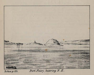
Images, John Helder Wedge, Port Fairy, Victoria, c1935
From Westgarth's 'Port Fairy Settlement'.Three images of Port Fairy, Victoria. port fairy, wedge, john helder wedge -
 Federation University Historical Collection
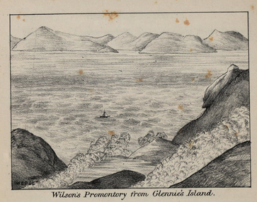
Image, John Helder Wedge, Glennie's Island, c1835
From Westgarth's 'Port Phillip Settlement'.Two images of Glennie's Island, Victoria.glennie's island, wedge, john helder wedge -
 Flagstaff Hill Maritime Museum and Village
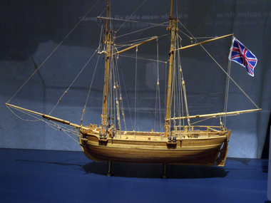
Craft - Ship Model, H.M.S. Lady Nelson, 1988
... , on the coast of Victoria, in establishing settlements on the River..., on the coast of Victoria, in establishing settlements on the River ...This model of the ship H.M.S. Lady Nelson was researched and built as the vessel Lady Nelson by David Lumsden, a professional ship model builder. His Majesty's Armed Survey Vessel Lady Nelson was commissioned in 1799 to survey the coast of Australia. This vessel was purpose-built before the British Admiralty requested plans for a Schooner for Port Jackson. At the time large parts of the Australian coast were unmapped and Britain had claimed only part of the continent. The British Government were concerned that, in the event of settlers of another European power becoming established in Australia, any future conflict in Europe would lead to a widening of the conflict into the southern hemisphere to the detriment of the trade that Britain sought to develop. Against this background, Lady Nelson was chosen to survey and establish sovereignty over strategic parts of the continent. Lady Nelson left Portsmouth on 18 March 1800 and arrived at Sydney on 16th December 1800 after having been the first vessel to reach the east coast of Australia via the Bass Strait. Before that date, all vessels had sailed around the southern tip of Tasmania to reach their destination. Lady Nelson's survey work commenced shortly after she arrived in Sydney, initially in the Bass Strait area. She was involved in the discovery of Port Phillip, on the coast of Victoria, in establishing settlements on the River Derwent and at Port Dalrymple in Tasmania. She also successfully chartered much of the Victorian coastline and was heavily involved with the exploration of the Queensland coast with Matthew Flinders; investigated the Hunter River; made numerous visits to New Zealand and Norfolk Island and was involved in the founding of numerous settlements. In comparison to most colonial vessels, the Lady Nelson was technically unique she was fitted with sliding keels, or centreboards, and water-tight trunks reaching to the deck. Captain Schank invented these sliding keels that, when raised, reduced her draught to less than six feet. Her life as an exploration vessel ended while accompanying HMS 'Tamar' to Melville Island in 1825, the 'Lady Nelson' was captured and later abandoned by pirates off the island of Babar (Indonesia). This brought the vessel's 25 years of coastal exploration and navigation to a close.The Lady Nelson made was the first British ship to survey of the southern or south-western coast of Australia and traverse the Bass Strait. The vessel holds a special place in Australia's history of exploration as the first to explore and establish settlements in the then-new British colony of Van Diemans Land. The model gives an insight into what life must have been like onboard sailing vessels of the time and Australia's early history of establishment and exploration. This model acts as an important legacy of the full-scale ship which no longer survives. Ship model of the 60 ton British brig HMS Lady Nelson. Timber model of a two-masted brig with rigging but no sails, displaying the British Union Jack flag. The ship is in a glass exhibition display case on metal stand. HMS Lady Nelsonflagstaff hill, warrnambool, shipwrecked coast, flagstaff hill maritime museum, maritime museum, shipwreck coast, flagstaff hill maritime village, great ocean road, by captain john schanck, sliding keels or centreboards, lady nelson, british brig hms lady nelson, david lumsden ship model builder, lieutennant james grant, bass strait discovery, surveying king island and port phillip bay, philip gidley king -
 Flagstaff Hill Maritime Museum and Village
Textile - Tapestry, 1988
A thousand years of Warrnambool history has been documented in this creative tapestry, woven in 1988. The Tapestry hangs in the Great Circle Gallery at Flagstaff Hill and complements the theme of the display. Three local women with the help of Museum staff researched and designed the tapestry, which was woven in 1988 from wool and cotton. It is 10 meters long and 70 cm deep and took 7 months to create. The tapestry introduces the seafaring theme of the Center and illustrates a timeline of events dating back to the arrival of Europeans in the Warrnambool area. It begins with the settlement of the area by Europeans and travels back in time as you walk further into the gallery, depicting shipwrecks along the coast, whaling of the area, early exploration by Europeans James Grant and Nicholas Baudin, back to the indigenous settlement of the area, represented by middens and indigenous symbols. (Interestingly prior to being hung in the gallery, the tapestry was originally hung with the intention of being framed from right to left). All materials in the cotton and wool tapestry, includinghand-dyed dyed wool, were prepared for a cost of $33,000. (This information is from Flagstaff Hill Maritime Village's Exhibit fact sheet)Tapestry of the early history of Warrnambool area, rectangular in shape. Materials include cotton and wool, some of the wool being hand dyed. Made in 1988 by local women.A plaque accompanies the Tapestry "Flagstaff Hill Maritime Tapestry / 1989 / Tapestry: Woven Cotton and Wool / Mary O'Brien Gerda Shanley / Judith Stewart Beryl Conlan"flagstaff hill, warrnambool, shipwrecked-coast, flagstaff-hill, flagstaff-hill-maritime-museum, maritime-museum, shipwreck-coast, flagstaff-hill-maritime-village, tapestry, warrnambool history, warrnambool textiles, south west victoria history, south west victoria timeline, indigenous people -
 Flagstaff Hill Maritime Museum and Village
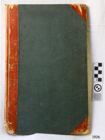
Financial record - Record Book, Warrnambool Lighthouse Book, ca. 1870s
... the colonisation of Victoria and the settlement of southwest Victoria ...Referencing works and removal of fittings and furnishings. Further on the book appears to have been used as a note book on further pages. WARRNAMBOOL'S LADY BAY LIGHTHOUSE COMPLEX; – The original Lady Bay Lighthouse Complex was built on Middle Island in 1858-1859 and comprised the Upper Light, Store (Chartroom), Cottage and Privy. The Lower Light was on a wooden tower on the beach of Lady Bay. In 1871 the Complex was transferred stone-by-stone to Flagstaff Hill, where the flagstaff had been installed since 1853. The Lower Light was erected on top of a bluestone obelisk that was built in 1854 as a navigational marker. The bluestone Lighthouse Keeper’s Quarters was a cottage divided into two compartments, one for the Senior Keeper and his family, the other for the Assistant Keeper and his family. The bluestone Store was divided into three; a store, a workshop, and an oil store (or office). The Privy was a small building divided into two separate, back-to-back toilet rooms, one for the Senior Keeper and his family and one for the Assistant Keeper and family. The record book from the Warrnambool Lighthouse is significant because of its connection with the Lady Bay Lighthouse Complex. The Lady Bay Lighthouse Complex is significant for its important role in the safe navigation of sailing and steam ships into and out of Lady Bay and the Port of Warrnambool. during the colonisation of Victoria and the settlement of southwest Victoria. The lighthouse also helped the passing ships to check the accuracy of their navigation along the southwest coast of Victoria and facilitated the call for help when vessels were in trouble.Warrnambool Lighthouse Book. Green hard covered book with red spine and reinforced corners. Inside are pages with printed horizontal linesBook detailing the cost of removal of the Lighthouse Station from Middle Island to its present location. Also other details. flagstaff hill, warrnambool, shipwrecked-coast, flagstaff-hill, flagstaff-hill-maritime-museum, maritime-museum, shipwreck-coast, flagstaff-hill-maritime-village, warrnambool lighthouse book, record of lighthouse relocation warrnambool, warrnambool historic record book, financial record, middle island -
Federation University Historical Collection
Book, The Pyreness Shire, Avoca Shire Heritage Study 1864-1994, Volume 1, 1995
The Pyreness Shire, Avoca Shire Heritage Study 1864-1994, Volume 11) 21008.1 - Volume 1 - Pale blue bound book of 47 pages - Environmental History 2) 21008.2 - Volume 3 - Pale blue bound book - Geographical Locations of Individual Sites, alphabetically by Road Namewendy jacobs, karen twigg, nigel lewis/richard aitken pty ltd, shire of avoca, avoca heritage study, national estate committee (victoria), national estate grants program, victorian goldfields, pyrenees, moonambel, natte yallock, rathscar, barkly, redbank, crowlands, landsborough, the pyrenees shire, lexton shire, exploration and pastoralism, gold, water, farming, wine and fruit, towns and settlements, living in community, road and rail, extractive industries, conclusion, ballarat, major mitchell, djadja wurrung aboriginal group, djab wurrung aboriginal group, avoca, lamplough, chinese camp, alluvial mining, ironbark mine, upper homebush, homebush deep lead mine, avoca and district historical society, deep leads, quartz mining, percydale, hog's reef mine, avoca, dredging, hunter's home, moonambel c. 1890, mrs ellen allan, lamplough, the 1865 land act, flour milling, flour mill, moonambel. c. 1880, harkins farm, bung bong c. 1900, dairying, viticulture, navarre, schools, churches, cemetaries, wars, hotels, halls, sports, horse racing, country fire authority, maryborough-avoca railway, cobb and co -
Federation University Historical Collection
Booklet, Reclaiming the Radical Spirit of the Eureka Rebellion, 2004, 2004
Orange covered booklet on the Eureka Stockade, direct democracy, Direct Action, Internationalism, Solidarity, Why an Apology (It's time for an apology from the Victoria police for their role in the Eureka Massacre in 1854), Birthplace of Australian Democracy? - Conservative Responses to Eureka and the 1901 Federal Constitution (by Ken Mansell), The Post-Eureka Settlementeureka stockade, anarchist media institute, ken mansell, democracy -
 Flagstaff Hill Maritime Museum and Village
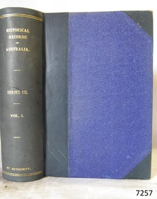
Book, Historical Records of Australia Series 3 Vol 1
"Historical Records of Australia Series 3 Vol 1 Port Phillip, Victoria, 1803-1804 Tasmania, 1803-June1812 " Despatches and Papers relating to the Settlement of the States Publisher: Library Committee of the Commonwealth Parliament Date: 1921Inside front cover has a sticker that reads Warrnambool Mechanics Institute and Free Library warrnambool, shipwrecked-coast, flagstaff-hill, flagstaff-hill-maritime-museum, maritime-museum, shipwreck-coast, flagstaff-hill-maritime-village, shipwrecked-artefact, book, warrnambool mechanics’ institute, mechanics’ institute -
 Flagstaff Hill Maritime Museum and Village
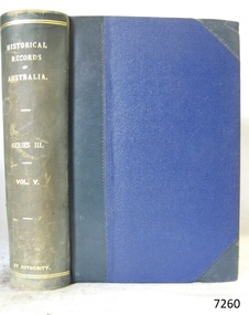
Book, Historical Records of Australia Series 3 Vol 5
"Historical Records of Australia Series 3 Vol 5 Tasmania, December, 1825- March, 1827 Northern territory, 1823- 1827 Western port, Victoria, 1826 - 1827" Despatches and Papers relating to the Settlement of the States Publisher: Library Committee of the Commonwealth Parliament Date: 1922Inside front cover has a sticker that reads Warrnambool Mechanics Institute and Free Library warrnambool, shipwrecked-coast, flagstaff-hill, flagstaff-hill-maritime-museum, maritime-museum, shipwreck-coast, flagstaff-hill-maritime-village, shipwrecked-artefact, book, warrnambool mechanics’ institute, mechanics’ institute, historical records of australia series 3 vol 5 -
 Flagstaff Hill Maritime Museum and Village
Book, The Logbooks of The Lady Nelson, 1915
This hardcover book, The logbooks of the 'Lady Nelson' : with the journal of her first commander, Lieutenant James Grant, R.N., by Ida Lee (Mrs Charles Bruce Marriott) was published over 100 years after the Lady Nelson arrived in Australia to navigate and survey this ‘new colony’. Included in the book are sixteen charts and illustrations from the originals in the Admiralty Library, showing the surveyed land and water. The transcribed Contents, below, summarise the trips of the Lady Nelson during this time. Book’s Content PLUS text of the Chart of ‘Part of Bass Strait’ - Chapter 1: The Lady Nelson built with centreboards. Her voyage to Sydney under James Grant. The first ship to pass through Bass Strait. - Chapter 2: Returns to explore the Strait. Her visits to Jervis Bay and to Western Port in 1801 - Chapter 3: Colonel Paterson and Lieutenant Grant survey Hunter River - Chapter 4: Murray appointed commander of the Lady Nelson. His voyage to Norfolk Island. - Chapter 5: Murray’s exploration of Bass Strait. - Chapter 6: Discovery of Port Phillip. - Chapter 7: The Lady Nelson in company with HMS Investigator examines the North-Eastern shores of Australia. - Chapter 8: The French ships in Bass Strait. The founding of Hobart. - Chapter 9: Symons succeeds Curtoys as commander of the Lady Nelson. His voyages to Tasmania, Port Phillip and New Zealand. - Chapter 10: The Lady Nelson in Tasmania. The founding of Port Dalrymple. - Chapter 11: The Estramina is brought to Sydney. The Lady Nelson visits Norfolk Island and Port Dalrymple. - Chapter 12: Tippahee and his four sons are conveyed to New Zealand in the Lady Nelson. - Chapter 13: The Lady Nelson accompanies HMS Tamar to Melville Island. - Chapter 14: The loss of the Lady Nelson Text included with the ‘Chart of Bass Strait’ … “Part of Bass Strait, including the discoveries made by Acting Lieut. J. Murray, commander of His Majesty’s armed surveying vessel Lady Nelson, between November 1801 and March 1802. By command of His Excellency Governor King.” “This chart, which bears Murray’s autograph, shows his explorations of Western Port, Port Phillip and King Island. It should be noted that Flinders Island is named Grand Capuchin. This is one of the charts referred to as "unfortunately missing” in the Historical Records of N.S. Wales, vol. iv. P. 764” The story of the Lady Nelson In 1798 the British Admiralty ordered a cutter of 60 tons to be built along the design of the armed cutter Trial that was developed by Captain John Schanck, with three sliding keels or centreboards that could be individually raised and lowered, for use on the River Thames. The new cutter was to be named Lady Nelson. Philip Gidley King, prior to taking up his appointment as third Governor of the colony of New South Wales, was in England at the time of the Lady Nelson’s fit-out and was aware of the need for such a ship for survey work in the colony in New South Wales. He convinced Captain Schanck, the Commissioner of Transport in England, to construct and rig the Lady Nelson as a brig rather than a cutter, keeping the feature of the three sliding keels, which would be very useful for mapping in shallow waters. The new Lady Nelson was launched at Deptford, England on the River Thames in November 1798, with the official commission to discover and survey the unknown parts of the coast of New Holland (Australia) and establish British sovereignty over the continent. The Lady Nelson sailed from Portsmouth, England on March 1800 under the command of Lieutenant James Grant. She carried an armament of two original and four extra brass carronade carriage guns and set sail as part of a convoy heading to Port Jackson, in New South Wales, New Holland. After a while she continued to sail on her own. Her journey was troubled with problems at times; damaged and broken keels, troublesome crew and leaking topsides between the waterline and the deck due to poor seals. She arrived at the Cape of Good Hope in July and waited for the winter to pass to avoid the strong winds of the ‘Roaring Forties’. While at the Cape, Grant received a despatch to travel to Port Jackson via the newly discovered Bass Strait, rather than the usual route via the tip of Van Diemen’s Land (Tasmania). This also gave him the opportunity to survey the strait on the way. He departed the Cape in October and in December he made his first sighting of New Holland near Mount Gambier in what is now South Australia. A report by Ecclestone in 2012, ‘The Early Charting of Victoria’s Coastline’, mentions that Grant charted and named Capes Banks and Northumberland, and sighted inland hills that he named Mt Gambier and Mt Schanck, the latter after the designer of his ship. Grant then reached the south-western shores of what is now Victoria on 3-4 December 1800, and from Cape Bridgewater he examined the coast eastward to Cape Patton. Although he had not continuously sighted the coast in the vicinity of Port Fairy and Warrnambool, the western part of Victoria became known as Grant’s Land. The Lady Nelson continued eastward and passed through Bass Strait, becoming the first vessel to reach the east coast of New Holland from the west, and arrived at her destination of Port Jackson later in December 1800. Grant, in the Lady Nelson, then left Port Jackson and began survey work. He discovered Port Phillip on Victoria’s coast and explored King Island, he helped establish the first European settlement in Tasmania on the Derwent River, and Port Dalrymple, Newcastle and Port Macquarie. He made several trips from Norfolk Island to Hobart Town. Governor Macquarie sailed on with him to Van Diemen’s Land for a tour of inspection in 1811. Grant helped establish the first settlement on Melville Island in Northern Australia. The Lady Nelson was used to transport cargo, civilians and convicts and to source pigs from Timor. In February 1825 the Lady Nelson sailed again for Timor and never returned. One report said that “Every soul on board, we regret to state, was cruelly massacred, and the hull of the vessel was seen some time after with the name painted on her stern.” The hull was sighted on the island of Babar, which is almost 200 kilometres east of Timor. This particular copy of the book ... This item is from the ‘Pattison Collection’, a collection of books and records that was originally owned by the Warrnambool Mechanics’ Institute, which was founded in Warrnambool in 1853. By 1886 the Warrnambool Mechanics’ Institute (WMI) had grown to have a Library, Museum and Fine Arts Gallery, with a collection of “… choice productions of art, and valuable specimens in almost every branch and many wonderful national curiosities are now to be seen there, including historic relics of the town and district.” It later included a School of Design. Although it was very well patronised, the lack of financial support led the WMI in 1911 to ask the City Council to take it over. In 1935 Ralph Pattison was appointed as City Librarian to establish and organise the Warrnambool Library as it was then called. When the WMI building was pulled down in 1963 a new civic building was erected on the site and the new Warrnambool Library, on behalf of the City Council, took over all the holdings of the WMI. At this time some of the items were separated and identified as the ‘Pattison Collection’, named after Ralph Pattison. Eventually the components of the WMI were distributed from the Warrnambool Library to various places, including the Art Gallery, Historical Society and Flagstaff Hill. Later some were even distributed to other regional branches of Corangamite Regional Library and passed to and fro. It is difficult now to trace just where all of the items have ended up. The books at Flagstaff Hill Maritime Village generally display stamps and markings from Pattison as well as a variety of other institutions including the Mechanics’ Institute itself. RALPH ERIC PATTISON Ralph Eric Pattison was born in Rockhampton, Queensland, in 1891. He married Maude Swan from Warrnambool in 1920 and they set up home in Warrnambool. In 1935 Pattison accepted a position as City Librarian for the Warrnambool City Council. His huge challenge was to make a functional library within two rooms of the Mechanics’ Institute. He tirelessly cleaned, cleared and sorted a disarrayed collection of old books, jars of preserved specimens and other items reserved for exhibition in the city’s museum. He developed and updated the library with a wide variety of books for all tastes, including reference books for students; a difficult task to fulfil during the years following the Depression. He converted all of the lower area of the building into a library, reference room and reading room for members and the public. The books were sorted and stored using a cataloguing and card index system that he had developed himself. He also prepared the upper floor of the building and established the Art Gallery and later the Museum, a place to exhibit the many old relics that had been stored for years for this purpose. One of the treasures he found was a beautiful ancient clock, which he repaired, restored and enjoyed using in his office during the years of his service there. Ralph Pattison was described as “a meticulous gentleman whose punctuality, floorless courtesy and distinctive neat dress were hallmarks of his character, and ‘his’ clock controlled his daily routine, and his opening and closing of the library’s large heavy doors to the minute.” Pattison took leave during 1942 to 1945 to serve in the Royal Australian Navy, Volunteer Reserve as Lieutenant. A few years later he converted one of the Museum’s rooms into a Children’s Library, stocking it with suitable books for the younger generation. This was an instant success. In the 1950’s he had the honour of being appointed to the Victorian Library Board and received more inspiration from the monthly conferences in Melbourne. He was sadly retired in 1959 after over 23 years of service, due to the fact that he had gone over the working age of council officers. However he continued to take a very keen interest in the continual development of the Library until his death in 1969 This book about the logbooks of the Lady Nelson is locally significant for its association with the brig Lady Nelson, in which Lt. James Grant made the first documented European discovery of the area later known as Warrnambool in December 1800. This book is also nationally significant for its association with Grant in the Lady Nelson being the first to sail from west to east through Bass Strait, opening up a shorter, faster route to the colony of Port Jackson rather than going all the way south around Van Diemen’s Land. The book is nationally significant for its contents of the logbooks of the journeys of the Lady Nelson under various commanders and the copies of the charts created from the surveyed information and the new land of Australia was discovered. This book is also significant for its association with the full-size non-sailing replica of the Lady Nelson from Mount Gambier’s visitor centre, which was restored by Flagstaff Hill’s Master Boat Builder in Warrnambool in 2012, and with a ship mode of the Lady Nelson in our Collection The Pattison Collection, along with other items at Flagstaff Hill Maritime Village, was originally part of the Warrnambool Mechanics' Institute’s collection. The Warrnambool Mechanics’ Institute Collection is primarily significant in its totality, rather than for the individual objects it contains. Its contents are highly representative of the development of Mechanics' Institute libraries across Australia, particularly Victoria. A diversity of publications and themes has been amassed, and these provide clues to our understanding of the nature of and changes in the reading habits of Victorians from the 1850s to the middle of the 20th century. The collection also highlights the Warrnambool community’s commitment to the Mechanics’ Institute, reading, literacy and learning in the regions, and proves that access to knowledge was not impeded by distance. These items help to provide a more complete picture of our community’s ideals and aspirations. The Warrnambool Mechanics Institute book collection has historical and social significance for its strong association with the Mechanics Institute movement and the important role it played in the intellectual, cultural and social development of people throughout the latter part of the nineteenth century and the early twentieth century. The collection of books is a rare example of an early lending library and its significance is enhanced by the survival of an original collection of many volumes. The Warrnambool Mechanics' Institute’s publication collection is of both local and state significance. The Logbooks of The Lady Nelson Author: Ida Lee ( Mrs Charles Bruce Marriott) Publisher: Grafton & Co Date: 1915Label on spine with typed text RA 910.994 LEE Inside front cover has a sticker that reads Warrnambool Mechanics Institute and Free Library shipwrecked-coast, flagstaff-hill, warrnambool, flagstaff-hill-maritime-museum, maritime-museum, shipwreck-coast, flagstaff-hill-maritime-village, shipwrecked-artefact, book, warrnambool library, warrnambool mechanics’ institute, warrnambool city librarian, mechanics’ institute library, victorian library board, warrnambool books and records, warrnambool children’s library, great ocean road, the logbooks of the lady nelson, ida lee, mrs charles bruce marriott, captain john schanck, sliding keels or centreboards, lady nelson, british brig hms lady nelson, lieutennant james grant, bass strait discovery, surveying king island and port phillip bay, philip gidley king, survey map -
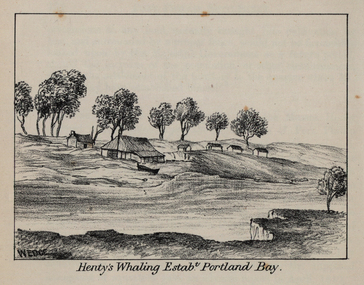 Federation University Historical Collection
Photograph - Image, John Helder Wedge, Portland Bay and Henty's House, 1835, 1835
From Westgarth's 'Port Phillip Settlement'.Three images of Portland Bay, including Henty's House, Whaling, and the Fishery. The Hentys were some of the earliest white settlers in the Port Phillip District of New South Wales (later Victoria).wedge, john helder wedge, portland, portland bay, fishery, henty, whaling, victoria, port phillip district -
 Federation University Historical Collection
Photographs - black and white, Henry John (Jack) Holmes of Ascot and Derrinallum, Victoria
Henry John (Jack) Holmes of Ascot was the eldest son of Henry Smerdon and Edith (nee Pickford) Holmes and brother to William Smerdon [Bill], David Coghill and Elizabeth (m Chatham) On his return from serving in WW2, Jack with his father's help took up a Soldier Settler option and settled at Derrinallum on a portion of Mout Elephant. The holding was named "Launchley Park". Soldiers, like Jack with their families, helped swell the numbers in the district and aided the growth in the town and the services it could provide.Three photographs. .1) Black and white photograph of Henry John (Jack) Holmes from Ascot and then Derinallum .2) and .3) Jack Holmes. jack holmes, chatham-holmes collection, henry smerdon holmes, derrinallum, western desert ww2, soldier settlement, mount elephant -
Glenelg Shire Council Cultural Collection
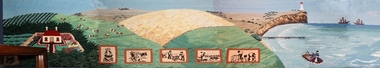
Print - Print Sticker - Portland 150th, 1984
... Front: Portland's 150th Anniverdary 1934-1984 Victoria's... Anniverdary 1934-1984 Victoria's First Permanent Settlement Oblong ...Glenelg Shire Council Records Dept.Front: Portland's 150th Anniverdary 1934-1984 Victoria's First Permanent Settlementglenelg shire, portland 150th -
Glenelg Shire Council Cultural Collection
Print - Print Sticker - Portland 150th, 1984
... Front: Portland's 150th Anniversary 1934-1984 Victoria's... Victoria's First Permanent Settlement Oblong-shaped promotional ...Glenelg Shire Council Records DeptFront: Portland's 150th Anniversary 1934-1984 Victoria's First Permanent Settlement -
Glenelg Shire Council Cultural Collection
Memorabilia - Sticker - Promoting Portlands 150th celebrations 1984, PORTLAND 150th, 1984
... Front: Portland's 150th Anniversary 1934-1984 Victoria's... Victoria's First Permanent Settlement Oblong - shaped promotional ...Glenelg Shire Council Record DepartmentFront: Portland's 150th Anniversary 1934-1984 Victoria's First Permanent Settlement -
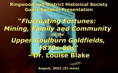 Ringwood and District Historical Society
Mixed media - Video, RDHS Guest Speaker Presentation - "Fluctuating Fortunes on the Upper Goulburn Goldfields 1870s-1880s" - Dr. Louise Blake
Digitised video (2.66GB) Duration: 51 minutes. Recorded August, 2022 (Video is available for viewing at Ringwood & District Historical Society Archives by appointment)Presenter: Louise Blake is a writer and historian with an interest in the stories of women, families, and communities on the nineteenth-century goldfields in Australia and New Zealand. Inspired by her family connection to the gold mining settlement of Woods Point, Louise completed a PhD on Women and Community on the Upper Goulburn Goldfields in north-east Victoria in 2019. In this talk Louise will share her research on Lawrence and Esther Chubb, who lived and worked at Gaffneys Creek on the Upper Goulburn Goldfields in the 1870s and 80s. In a series of letters Lawrence wrote to his family in England, and now held by the State Library of Victoria, Lawrence shared his early struggles as an independent miner on the central Victorian goldfields, his protracted courtship with Esther, the ordinary intimacies of their life at Gaffneys Creek, the work that Esther did to support the family in this remote mining region, as well as the material and emotional support provided by and to family, friends and neighbours. A rare and revealing source, these letters help to expand our understanding of the lived experience of mining families, particularly the work that women did to sustain families and communities, in this period of waged labour and tribute mining in Victoria. -
 Ringwood and District Historical Society
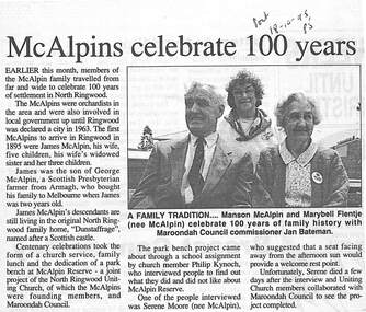
Newspaper, Scrapbook Clipping, Library Collection, Ringwood, Victoria
Newspaper Clipping from "The Post", 18 October, 1995. P5. "McAlpins celebrate 100 years.In October 1995, members of the McAlpin family travelled from far and wide to celenbrate 100 years of settlement in North Ringwood. The McAlpins were orchardists in the area and were in Local Government. -
 City of Moorabbin Historical Society (Operating the Box Cottage Museum)
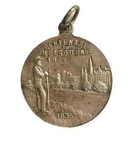
Badge - Centenary of Melbourne, c. 1935-35
... references Portland, the location of Victoria’s first settlement..., the location of Victoria’s first settlement. The Henty brothers ...White metal medal issued to commemorate Melbourne’s centenary 1934-35. This medal was given out to Victorian school children; 325,600 white metal medals were struck. The medal references Portland, the location of Victoria’s first settlement. The Henty brothers, entrepreneur farmers and whalers, established the state’s first permanent European settlement in Portland in 1834. Melbourne was established the following year by a party of settlers led by John Batman. In 1934, as Melbourne planned to celebrate the centenary of European settlement, it seemed to some that there was little to celebrate. The financial strains of the depression, unemployment and the scandal of the city’s slums all undercut claims of unbridled progress. Perhaps because of such troubles, the organisers of the centenary celebrations tried doubly hard to be positive. The themes of the celebrations were conservative, reflecting the desire of some Melburnians for security in troubled times. The widely promoted image of the ‘Garden City’ and ‘Queen City of the South’ emphasised the idea of Melbourne as a very British city. White metal badgeCentenary of Melbournemelbourne centenary, victorian school children -
 City of Moorabbin Historical Society (Operating the Box Cottage Museum)
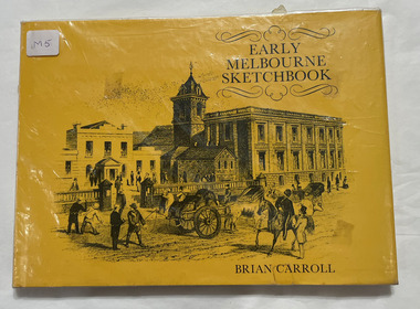
Book, Carroll, Brian, Early Melbourne sketchbook, 1977
In 1839 a runaway horse crashed into a tree stump that stood in the middle of Bourke Street; and in 1840 there were holes in Collins Street so deep that a child was nearly drowned in one. Early Melbourne Sketchbook recaptures the exciting early days of the city, days when rainy weather rendered Elizabeth Street impassable without a punt, and when Melbourne's first city councillor was elected on the promise of free beer to his constituents. Brian Carroll has sought out an interesting collection of contemporary illustrations to take us back to the beginning of Melbourne, from the original discovery of Port Phillip in 1802. David Collins' abortive settlement at Sullivan's Bay was abandoned in 1803, and it was not until 1835 that John Batman settled on his now famous 'place for a village'. Here are fascinating stories of the men who founded and shaped Victoria's capital city: Batman, Fawkner, Bourke, La Trobe. In addition, there is a wealth of information about Melbourne's buildings and landmarks - places such as St Francis', the Post Office, the Town Hall, Princes Bridge, and Young and Jackson's. Early Melbourne Sketchbook describes vividly the historical development and cultural growth of the city that was to become Australia's financial capital and its second largest city. (Inside cover)62 pages : illustratednon-fictionIn 1839 a runaway horse crashed into a tree stump that stood in the middle of Bourke Street; and in 1840 there were holes in Collins Street so deep that a child was nearly drowned in one. Early Melbourne Sketchbook recaptures the exciting early days of the city, days when rainy weather rendered Elizabeth Street impassable without a punt, and when Melbourne's first city councillor was elected on the promise of free beer to his constituents. Brian Carroll has sought out an interesting collection of contemporary illustrations to take us back to the beginning of Melbourne, from the original discovery of Port Phillip in 1802. David Collins' abortive settlement at Sullivan's Bay was abandoned in 1803, and it was not until 1835 that John Batman settled on his now famous 'place for a village'. Here are fascinating stories of the men who founded and shaped Victoria's capital city: Batman, Fawkner, Bourke, La Trobe. In addition, there is a wealth of information about Melbourne's buildings and landmarks - places such as St Francis', the Post Office, the Town Hall, Princes Bridge, and Young and Jackson's. Early Melbourne Sketchbook describes vividly the historical development and cultural growth of the city that was to become Australia's financial capital and its second largest city. (Inside cover)melbourne, historic buildings -
 Colac & District Historical Society
presentation silver jug, Untitled
Presented to Mr. Connor, M.L.A., Colony of Victoria by the Electors of the district of Colac, inappreciation of his service as their representative. 27/6/1866This jug is part of a significant set of silverware made especially for the people of Colac in the early days of the settlement. It is of great local significanceSterling silver jug with ornate single handle and detailed embossing on the lip. Four filigree feet. Elaborate embossing on the bottom - an emu, three kangaroos and a man shootingSterling sliver hallmark on base and family intitals in script engraved on side of jug "JFC"presentation silver jug, connor mla -
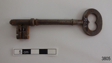
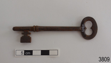
 Flagstaff Hill Maritime Museum and Village
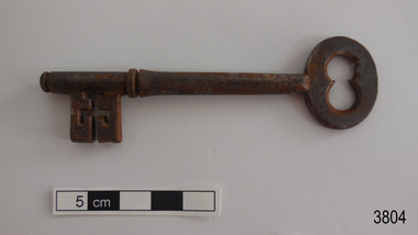
Functional object - Key, circa 1866
The key is one of a collection of seven 1860s keys once belonged to the Glenample Homestead near Princetown. They are all keyed with different bits and would have opened the external panelled doors of the Georgian building. The keys would now be around 150 years old. The keys are now part of the John Chance Collection. Locksmiths became a recognised trade by the middle of the 19th century, doing work that blacksmiths and gunsmiths would have done. They were craftsmen and trained apprentices for their trade. The local community and businesses relied on them for making a wide variety of precision objects such as locks and keys, knives, ornamental and decorative latticework, fine instruments, accurate tools and hardware items. Glenample Homestead became famous after the disastrous wreck of the sailing ship Loch Ard on June 1, 1878. The owners, Hugh Hamilton Gibson and Peter McArthur, were involved in the rescue and recovery of Eva Carmichael and Tom Pearce, the only two survivors, as well as overseeing the salvage of items from the shipwreck and the burial of those who lost their lives. Eva first met Jane Shields at Glenample and they became long-time friends. The keys are significant as an example of mid-19th century locksmith hardware, and for their connection with Glenample Homestead, and for their connection to the history of the Loch Ard shipwreck’s only two survivors. The set of keys also hold significance as they were discovered by John Chance, who was also a diver from the wreck of the Loch Ard in the 1960s-70s. Items that come from several wrecks along Victoria's coast have since been donated to the Flagstaff Hill Maritime Village’s museum collection by his family, illustrating this item’s level of historical value. Glenample Homestead is of historical, social and architectural significance to the State of Victoria and is listed on the Victorian Heritage Register (VHR H0392). It is a historical example of early settlement and development of a run in the coastal land of South West Victoria, and it is constructed from locally quarried sandstone but doesn’t take away from its Georgian design. Glenample Homestead is of State significance through its unique connection with the wreck of the ship Loch Ard and the connection to its owners, Hugh and Lavinia Gibson and Peter McArthur, played a historically and socially significant role in the rescue and care of the survivors, the salvage of goods and the burial of those who lost their lives. The shipwreck of the Loch Ard itself is of significance for Victoria and is registered on the Victorian Heritage Register (S417). Key; steel domestic door key. Flat open bow with 'figure 8' space, round shank that flares out slightly above the collar on the bit. The rectangular bit has internal notches and grooves. There is a rounded pin on the end.flagstaff hill, warrnambool, flagstaff hill maritime museum, maritime museum, shipwreck coast, flagstaff hill maritime village, great ocean road, glenample homestead, victorian heritage register vhr h0392, georgian homestead, loch ard, princetown, jane shields, eva carmichael, tom pearce, blue china tea set, antique door key, glenample photographs, john chance -
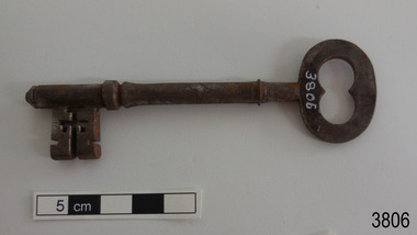
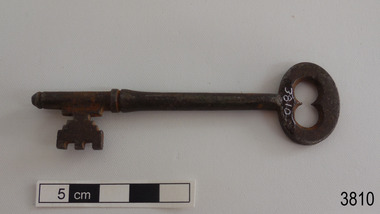
 Flagstaff Hill Maritime Museum and Village
Functional object - Key, circa 1866
The key is one of a collection of seven 1860s keys once belonged to the Glenample Homestead near Princetown. They are all keyed with different bits and would have opened the external panelled doors of the Georgian building. The keys would now be around 150 years old. The keys are now part of the John Chance Collection. Locksmiths became a recognised trade by the middle of the 19th century, doing work that blacksmiths and gunsmiths would have done. They were craftsmen and trained apprentices for their trade. The local community and businesses relied on them for making a wide variety of precision objects such as locks and keys, knives, ornamental and decorative latticework, fine instruments, accurate tools and hardware items. Glenample Homestead became famous after the disastrous wreck of the sailing ship Loch Ard on June 1, 1878. The owners, Hugh Hamilton Gibson and Peter McArthur, were involved in the rescue and recovery of Eva Carmichael and Tom Pearce, the only two survivors, as well as overseeing the salvage of items from the shipwreck and the burial of those who lost their lives. Eva first met Jane Shields at Glenample and they became long-time friends. The keys are significant as an example of mid-19th century locksmith hardware, and for their connection with Glenample Homestead, and for their connection to the history of the Loch Ard shipwreck’s only two survivors. Glenample Homestead is of historical, social and architectural significance to the State of Victoria and is listed on the Victorian Heritage Register (VHR H0392). It is a historical example of early settlement and development of a run in the coastal land of South West Victoria, and it is constructed from locally quarried sandstone but doesn’t take away from its Georgian design. Glenample Homestead is of State significance through its unique connection with the wreck of the ship Loch Ard and the connection to its owners, Hugh and Lavinia Gibson and Peter McArthur, played a historically and socially significant role in the rescue and care of the survivors, the salvage of goods and the burial of those who lost their lives. The shipwreck of the Loch Ard itself is of significance for Victoria and is registered on the Victorian Heritage Register (S417). Key; steel domestic door key. Flat open bow with 'figure 8' space, collar on shank, close to the bow. Round shank flares out slightly above the collar on the bit. The rectangular bit has internal and external notches and grooves. There is a rounded pin on the end.flagstaff hill, warrnambool, flagstaff hill maritime museum, maritime museum, shipwreck coast, flagstaff hill maritime village, great ocean road, glenample homestead, victorian heritage register vhr h0392, georgian homestead, loch ard, princetown, jane shields, eva carmichael, tom pearce, blue china tea set, antique door key, glenample photographs, john chance -
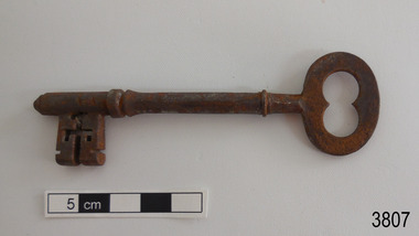
 Flagstaff Hill Maritime Museum and Village
Functional object - Key, circa 1866
The key is one of a collection of seven 1860s keys once belonged to the Glenample Homestead near Princetown. They are all keyed with different bits and would have opened the external panelled doors of the Georgian building. The keys would now be around 150 years old. The keys are now part of the John Chance Collection. Locksmiths became a recognised trade by the middle of the 19th century, doing work that blacksmiths and gunsmiths would have done. They were craftsmen and trained apprentices for their trade. The local community and businesses relied on them for making a wide variety of precision objects such as locks and keys, knives, ornamental and decorative latticework, fine instruments, accurate tools and hardware items. Glenample Homestead became famous after the disastrous wreck of the sailing ship Loch Ard on June 1, 1878. The owners, Hugh Hamilton Gibson and Peter McArthur, were involved in the rescue and recovery of Eva Carmichael and Tom Pearce, the only two survivors, as well as overseeing the salvage of items from the shipwreck and the burial of those who lost their lives. Eva first met Jane Shields at Glenample and they became long-time friends.The keys are significant as an example of mid-19th century locksmith hardware, and for their connection with Glenample Homestead, and for their connection to the history of the Loch Ard shipwreck’s only two survivors. The set of keys also hold significance as they were discovered by John Chance, who was also a diver from the wreck of the Loch Ard in the 1960s-70s. Items that come from several wrecks along Victoria's coast have since been donated to the Flagstaff Hill Maritime Village’s museum collection by his family, illustrating this item’s level of historical value. Glenample Homestead is of historical, social and architectural significance to the State of Victoria and is listed on the Victorian Heritage Register (VHR H0392). It is a historical example of early settlement and development of a run in the coastal land of South West Victoria, and it is constructed from locally quarried sandstone but doesn’t take away from its Georgian design. Glenample Homestead is of State significance through its unique connection with the wreck of the ship Loch Ard and the connection to its owners, Hugh and Lavinia Gibson and Peter McArthur, played a historically and socially significant role in the rescue and care of the survivors, the salvage of goods and the burial of those who lost their lives. The shipwreck of the Loch Ard itself is of significance for Victoria and is registered on the Victorian Heritage Register (S417). Key; steel domestic door key. Flat open bow with 'figure 8' space, narrow collar on shank, close to the bow. Round shank flares out slightly above the collar on the bit. The rectangular bit has internal and external notches and grooves. There is a rounded pin on the end.flagstaff hill, warrnambool, flagstaff hill maritime museum, maritime museum, shipwreck coast, flagstaff hill maritime village, great ocean road, glenample homestead, victorian heritage register vhr h0392, georgian homestead, loch ard, princetown, jane shields, eva carmichael, tom pearce, blue china tea set, antique door key, glenample photographs, john chance -
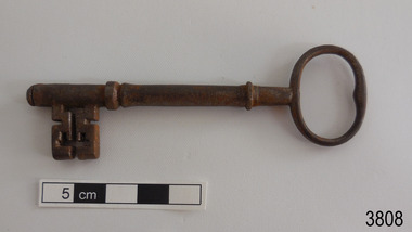
 Flagstaff Hill Maritime Museum and Village
Functional object - Key, circa 1866
The key is one of a collection of seven 1860s keys once belonged to the Glenample Homestead near Princetown. They are all keyed with different bits and would have opened the external panelled doors of the Georgian building. The keys would now be around 150 years old. The keys are now part of the John Chance Collection. Locksmiths became a recognised trade by the middle of the 19th century, doing work that blacksmiths and gunsmiths would have done. They were craftsmen and trained apprentices for their trade. The local community and businesses relied on them for making a wide variety of precision objects such as locks and keys, knives, ornamental and decorative latticework, fine instruments, accurate tools and hardware items. Glenample Homestead became famous after the disastrous wreck of the sailing ship Loch Ard on June 1, 1878. The owners, Hugh Hamilton Gibson and Peter McArthur, were involved in the rescue and recovery of Eva Carmichael and Tom Pearce, the only two survivors, as well as overseeing the salvage of items from the shipwreck and the burial of those who lost their lives. Eva first met Jane Shields at Glenample and they became long-time friends. The keys are significant as an example of mid-19th century locksmith hardware, and for their connection with Glenample Homestead, and for their connection to the history of the Loch Ard shipwreck’s only two survivors. The set of keys also hold significance as they were discovered by John Chance, who was also a diver from the wreck of the Loch Ard in the 1960s-70s. Items that come from several wrecks along Victoria's coast have since been donated to the Flagstaff Hill Maritime Village’s museum collection by his family, illustrating this item’s level of historical value. Glenample Homestead is of historical, social and architectural significance to the State of Victoria and is listed on the Victorian Heritage Register (VHR H0392). It is a historical example of early settlement and development of a run in the coastal land of South West Victoria, and it is constructed from locally quarried sandstone but doesn’t take away from its Georgian design. Glenample Homestead is of State significance through its unique connection with the wreck of the ship Loch Ard and the connection to its owners, Hugh and Lavinia Gibson and Peter McArthur, played a historically and socially significant role in the rescue and care of the survivors, the salvage of goods and the burial of those who lost their lives. The shipwreck of the Loch Ard itself is of significance for Victoria and is registered on the Victorian Heritage Register (S417). Key; steel domestic door key. Flat open bow with 'figure 8' space, narrow collar on shank, close to the bow. Round shank flares out slightly above the collar on the bit. The Rectangular bit has internal and external notches and grooves. There is a rounded pin on the end.flagstaff hill, warrnambool, flagstaff hill maritime museum, maritime museum, shipwreck coast, flagstaff hill maritime village, great ocean road, glenample homestead, victorian heritage register vhr h0392, georgian homestead, loch ard, princetown, jane shields, eva carmichael, tom pearce, blue china tea set, antique door key, glenample photographs, john chance -
 Flagstaff Hill Maritime Museum and Village
Functional object - Key, circa 1866
The key is one of a collection of seven 1860s keys once belonged to the Glenample Homestead near Princetown. They are all keyed with different bits and would have opened the external panelled doors of the Georgian building. The keys would now be around 150 years old. The keys are now part of the John Chance Collection. Locksmiths became a recognised trade by the middle of the 19th century, doing work that blacksmiths and gunsmiths would have done. They were craftsmen and trained apprentices for their trade. The local community and businesses relied on them for making a wide variety of precision objects such as locks and keys, knives, ornamental and decorative latticework, fine instruments, accurate tools and hardware items. Glenample Homestead became famous after the disastrous wreck of the sailing ship Loch Ard on June 1, 1878. The owners, Hugh Hamilton Gibson and Peter McArthur, were involved in the rescue and recovery of Eva Carmichael and Tom Pearce, the only two survivors, as well as overseeing the salvage of items from the shipwreck and the burial of those who lost their lives. Eva first met Jane Shields at Glenample and they became long-time friends. The keys are significant as an example of mid-19th century locksmith hardware, and for their connection with Glenample Homestead, and for their connection to the history of the Loch Ard shipwreck’s only two survivors. The set of keys also hold significance as they were discovered by John Chance, who was also a diver from the wreck of the Loch Ard in the 1960s-70s. Items that come from several wrecks along Victoria's coast have since been donated to the Flagstaff Hill Maritime Village’s museum collection by his family, illustrating this item’s level of historical value. Glenample Homestead is of historical, social and architectural significance to the State of Victoria and is listed on the Victorian Heritage Register (VHR H0392). It is a historical example of early settlement and development of a run in the coastal land of South West Victoria, and it is constructed from locally quarried sandstone but doesn’t take away from its Georgian design. Glenample Homestead is of State significance through its unique connection with the wreck of the ship Loch Ard and the connection to its owners, Hugh and Lavinia Gibson and Peter McArthur, played a historically and socially significant role in the rescue and care of the survivors, the salvage of goods and the burial of those who lost their lives. The shipwreck of the Loch Ard itself is of significance for Victoria and is registered on the Victorian Heritage Register (S417). Key; steel domestic door key. Round, thin open bow with 'B' shaped internal space, collar on shank, close to the bow. Round shank flares out slightly above the collar on the bit. The rectangular bit has internal and external notches and grooves. There is a rounded pin on the end.flagstaff hill, warrnambool, flagstaff hill maritime museum, maritime museum, shipwreck coast, flagstaff hill maritime village, great ocean road, glenample homestead, victorian heritage register vhr h0392, georgian homestead, loch ard, princetown, jane shields, eva carmichael, tom pearce, blue china tea set, antique door key, glenample photographs, john chance -
 Flagstaff Hill Maritime Museum and Village
Functional object - Key, circa 1866
The key is one of a collection of seven 1860s keys once belonged to the Glenample Homestead near Princetown. They are all keyed with different bits and would have opened the external panelled doors of the Georgian building. The keys would now be around 150 years old. The keys are now part of the John Chance Collection. Locksmiths became a recognised trade by the middle of the 19th century, doing work that blacksmiths and gunsmiths would have done. They were craftsmen and trained apprentices for their trade. The local community and businesses relied on them for making a wide variety of precision objects such as locks and keys, knives, ornamental and decorative latticework, fine instruments, accurate tools and hardware items. Glenample Homestead became famous after the disastrous wreck of the sailing ship Loch Ard on June 1, 1878. The owners, Hugh Hamilton Gibson and Peter McArthur, were involved in the rescue and recovery of Eva Carmichael and Tom Pearce, the only two survivors, as well as overseeing the salvage of items from the shipwreck and the burial of those who lost their lives. Eva first met Jane Shields at Glenample and they became long-time friends. The keys are significant as an example of mid-19th century locksmith hardware, and for their connection with Glenample Homestead, and for their connection to the history of the Loch Ard shipwreck’s only two survivors. The set of keys also hold significance as they were discovered by John Chance, who was also a diver from the wreck of the Loch Ard in the 1960s-70s. Items that come from several wrecks along Victoria's coast have since been donated to the Flagstaff Hill Maritime Village’s museum collection by his family, illustrating this item’s level of historical value. Glenample Homestead is of historical, social and architectural significance to the State of Victoria and is listed on the Victorian Heritage Register (VHR H0392). It is a historical example of early settlement and development of a run in the coastal land of South West Victoria, and it is constructed from locally quarried sandstone but doesn’t take away from its Georgian design. Glenample Homestead is of State significance through its unique connection with the wreck of the ship Loch Ard and the connection to its owners, Hugh and Lavinia Gibson and Peter McArthur, played a historically and socially significant role in the rescue and care of the survivors, the salvage of goods and the burial of those who lost their lives. The shipwreck of the Loch Ard itself is of significance for Victoria and is registered on the Victorian Heritage Register (S417). Key; steel domestic door key. Flat open bow with 'figure 8' space. Round narrow shank flares out slightly above the collar on the bit. The rectangular bit has has external notches and grooves. There is a rounded pin on the end.flagstaff hill, warrnambool, flagstaff hill maritime museum, maritime museum, shipwreck coast, flagstaff hill maritime village, great ocean road, glenample homestead, victorian heritage register vhr h0392, georgian homestead, loch ard, princetown, jane shields, eva carmichael, tom pearce, blue china tea set, antique door key, glenample photographs, john chance -
 Flagstaff Hill Maritime Museum and Village
Functional object - Key, circa 1866
The key is one of a collection of seven 1860s keys once belonged to the Glenample Homestead near Princetown. They are all keyed with different bits and would have opened the external panelled doors of the Georgian building. The keys would now be around 150 years old. The keys are now part of the John Chance Collection. Locksmiths became a recognised trade by the middle of the 19th century, doing work that blacksmiths and gunsmiths would have done. They were craftsmen and trained apprentices for their trade. The local community and businesses relied on them for making a wide variety of precision objects such as locks and keys, knives, ornamental and decorative latticework, fine instruments, accurate tools and hardware items. Glenample Homestead became famous after the disastrous wreck of the sailing ship Loch Ard on June 1, 1878. The owners, Hugh Hamilton Gibson and Peter McArthur, were involved in the rescue and recovery of Eva Carmichael and Tom Pearce, the only two survivors, as well as overseeing the salvage of items from the shipwreck and the burial of those who lost their lives. Eva first met Jane Shields at Glenample and they became long-time friends.The keys are significant as an example of mid-19th century locksmith hardware, and for their connection with Glenample Homestead, and for their connection to the history of the Loch Ard shipwreck’s only two survivors. The set of keys also hold significance as they were discovered by John Chance, who was also a diver from the wreck of the Loch Ard in the 1960s-70s. Items that come from several wrecks along Victoria's coast have since been donated to the Flagstaff Hill Maritime Village’s museum collection by his family, illustrating this item’s level of historical value. Glenample Homestead is of historical, social and architectural significance to the State of Victoria and is listed on the Victorian Heritage Register (VHR H0392). It is a historical example of early settlement and development of a run in the coastal land of South West Victoria, and it is constructed from locally quarried sandstone but doesn’t take away from its Georgian design. Glenample Homestead is of State significance through its unique connection with the wreck of the ship Loch Ard and the connection to its owners, Hugh and Lavinia Gibson and Peter McArthur, played a historically and socially significant role in the rescue and care of the survivors, the salvage of goods and the burial of those who lost their lives. The shipwreck of the Loch Ard itself is of significance for Victoria and is registered on the Victorian Heritage Register (S417). Key; steel domestic door key. Flat open bow with 'figure 8' space, collar on shank, close to the bow. Round shank flares out slightly above the collar on the bit. The rectangular bit has external notches and grooves. There is a rounded pin on the end.flagstaff hill, warrnambool, flagstaff hill maritime museum, maritime museum, shipwreck coast, flagstaff hill maritime village, great ocean road, glenample homestead, victorian heritage register vhr h0392, georgian homestead, loch ard, princetown, jane shields, eva carmichael, tom pearce, blue china tea set, antique door key, glenample photographs, john chance -
 Flagstaff Hill Maritime Museum and Village
Photograph - Set of Photographs, John Chance, late 1960s to early 1970s
This set of glossy black and white photographs is a set of images of Glenample Homestead circa late 1960s to early 1970s. They were taken by John Chance and are part of the John Chance Collection. The Colonial Georgian style Glenample Homestead was built from 1866 to 1869 from locally quarried sandstone. In is built on the top of a hill amongst trees. There are paddocks below and around the building. The building is basically a rectangular shape with a recessed room on the right side of the front. The pitched roof is covered in corrugated iron. The veranda, added in 1886, also has a corrugated iron room and is supported by square posts with decorative tops. It shelters three sides of the building. The edge of the veranda is decorated with scalloped shapes along the front and left side of the building. On the right is a brick wall incorporating a chimney. Another chimney on the left is contained within the building. The four-panelled outside doors are visible in some of the photos, as are the 12-paned glass windows, which are framed in contrasting stone. The veranda is trimmed with scalloped metal work on two sides and had some enclosed corners. There appears to be a cubical water tank on the roof line. Out-buildings include a toilet built against the house's brick wall. Another building appears to have two rooms with outside doors, perhaps for workers. There is the remains of a two-wheeled cart under a shelter. GLENAMPLE & the LOCH ARD Glenample Homestead became famous after the disastrous wreck of the sailing ship Loch Ard on June 1, 1878. The owners, Hugh Hamilton Gibson and Peter McArthur, were involved in the rescue and recovery of the only two survivors, as well as overseeing the salvage of items from the shipwreck and the burial of those who lost their lives. Glenample Homestead is on the Great Ocean Road at Princetown. Originally the land was part of Kennan’s Station lease, one of the district’s early settlements, circa 1847. James Murray bought Kerman’s land in 1856-57, combined it with nearby land, and named it Glenample Homestead. The ruins of huts Murray built on the property were still there until recently. Glenample was sold in 1866 to the partnership of Gibson and McArthur, who built a Georgian style house there using local sandstone, completing it by 1869. On 1st June 1878 the Loch Ard was wrecked at what is now called Loch Ard Gorge. Apprentice crewman Tom Pearce and eighteen year old passenger Eva Carmichael were the only survivors. Pearce had brought Eva ashore and sheltered her in a cave, reviving her with whiskey found amongst items washed up from the wreck. He climbed the cliffs and came across two riders from Glenample. No other survivors were found and sadly, Eva’s family members were amongst those who drowned. Hugh and Lavinia Gibson cared for Pearce and Eva at Glenample and extended their hospitality to Eva, who stayed on for about six weeks as she recovered from the ordeal physically and emotionally. Mrs Gibson introduced Eva to Jane Shields and the young ladies became lifelong friends. Years after Eva had returned to England, Jane’s daughter visited her. Eva handed her a blue china tea set to pass onto her mother as a gift. A descendant of Jane’s donated part of the tea set to Flagstaff Hill Maritime Village while another descendant donated her inherited share of the tea set to the Warrnambool and District Historical Society. In 1886 Glenample Homestead was updated to include a veranda on three sides. In 1887 Gibson sold his share to partner Peter McArthur. McArthur’s son Ernest inherited the property in 1897. Ernest established the Glenample Cheese Factory in around 1911. It was closed due to the World War and reopened in 1929 by McArthur’s sons, Robert and Colin, when they took control. In 1945 they sold Glenample and several owners followed but it was left unoccupied and became dilapidated. It was during this time that John Chance visited the property and photographed the buildings. In the 1980s the National Parks Service acquired the Glenample Homestead and began a restoration program. Work began in 1989 by Cathedral Stone, which was established in 1989 by James Charlwood, a specialist stonemason and son of maritime author Don Charlwood. This set of photographs are significant as a record of Glenample Homestead as it was from around the late 1860s to the late 1960s. The photographs are also significant as they were taken by John Chance, a diver from the wreck of the Loch Ard in the 1960s-70s. Items that come from several wrecks along Victoria's coast have since been donated to the Flagstaff Hill Maritime Village’s museum collection by his family, illustrating this item’s level of historical value. The photographs are significant as a link between Glenample, the vessel Loch Ard, and the only survivors of the Loch Ard. Glenample Homestead is of historical, social and architectural significance to the State of Victoria and is listed on the Victorian Heritage Register (VHR H0392). It is a historical example of early settlement and development of a run in the coastal land of South West Victoria, and it is constructed from locally quarried sandstone but doesn’t take away from its Georgian design. Glenample Homestead is of State significance through its unique connection with the wreck of the ship Loch Ard and the connection to its owners, Hugh and Lavinia Gibson and Peter McArthur, played a historically and socially significant role in the rescue and care of the survivors, the salvage of goods and the burial of those who lost their lives. The shipwreck of the Loch Ard itself is of significance for Victoria and is registered on the Victorian Heritage Register (S417). The set of ten rectangular black and white photographs of the Glenample Homestead, taken in the late 1960s or early 1970s, give san overview of the Glenample property. The views include the front, back and one side of the building, three outbuildings, and the situation of the homestead on the property. The details on the photographs show the materials used and the Colonial Georgian style. The photographs are also a record of the deterioration of the property over the years it was unoccupied.flagstaff hill, warrnambool, flagstaff hill maritime museum, maritime museum, shipwreck coast, flagstaff hill maritime village, great ocean road, kennans station, glenample homestead, georgian homestead, loch ard, princetown, victoria, james murray, hugh hamilton gibson, lavinia gibson, jane shields, eva carmichael, tom pearce, blue china tea set, peter mcarthur, ernest mcarthur, robert mcarthur, colin mcarthur, glenample cheese factory, cathedral stone, don charlwood, james charlwood, antique door key, glenample photographs, john chance, victorian heritage database 392