Showing 435 items matching "spring creek"
-
 Eltham District Historical Society Inc
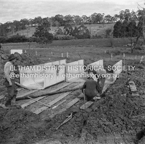
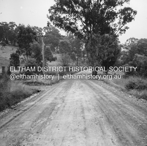
Negative - Photograph, J.A. McDonald, Hurstbridge-Arthurs Creek Road, Aug. 1960
Laying culverts on boards A. Gillies, F. Wood, G. BlairRecord of various Shire of Eltham infrastructure works undertaken during the period of 1952-1962 involving bridge and road reconstruction projects, sometimes with Eltham Shire Council Project Reference numbers quoted. It was during this period that a number of significant improvements were made to roads and new bridges constructed within the shire that remain in place as of present day (2022). In many situations, the photos provide a tangible visible record of infrastructure that existed throughout the early days of the Shire. The album was put together by or under the direction of the Shire Engineer, J.A. McDonald.infrastructure, shire of eltham, 1960-08, a. gillies, f. wood, g. blair, hurstbridge-arthurs creek road, bridge construction, road construction -
 Eltham District Historical Society Inc
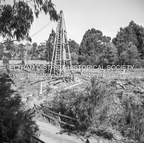
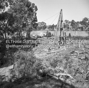
Negative - Photograph, J.A. McDonald, Hurstbridge-Arthurs Creek Road, Aug. 1960
Culvert at Patullo’s CA 34H1 Sec. B, Parish of Greensborough F. Wood Drott and truck Council crane August 1960Record of various Shire of Eltham infrastructure works undertaken during the period of 1952-1962 involving bridge and road reconstruction projects, sometimes with Eltham Shire Council Project Reference numbers quoted. It was during this period that a number of significant improvements were made to roads and new bridges constructed within the shire that remain in place as of present day (2022). In many situations, the photos provide a tangible visible record of infrastructure that existed throughout the early days of the Shire. The album was put together by or under the direction of the Shire Engineer, J.A. McDonald.infrastructure, shire of eltham, 1960-08, hurstbridge-arthurs creek road, bridge construction, bulldozer, cranes, drott, road construction -
 Eltham District Historical Society Inc
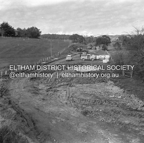
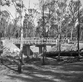
Negative - Photograph, J.A. McDonald, Henley Road at Watsons Creek, Mar. 1961
Old bridge over Watsons Creek 22 March 1961 Cr. Pelling and Contractor WolfRecord of various Shire of Eltham infrastructure works undertaken during the period of 1952-1962 involving bridge and road reconstruction projects, sometimes with Eltham Shire Council Project Reference numbers quoted. It was during this period that a number of significant improvements were made to roads and new bridges constructed within the shire that remain in place as of present day (2022). In many situations, the photos provide a tangible visible record of infrastructure that existed throughout the early days of the Shire. The album was put together by or under the direction of the Shire Engineer, J.A. McDonald.infrastructure, shire of eltham, 1961-03, bend of islands, cr. charis pelling, henley road, henley road bridge, kangaroo ground, oxley bridge, watsons creek, w.e. wolf, bridge construction, road construction -
 Eltham District Historical Society Inc
Negative - Photograph, J.A. McDonald, Henley Road at Watsons Creek, Mar. 1961
Henley Road at Watsons Creek Looking easterly along new alignment, 22 March 1961 C. Browns Excavator Contractor Wolf Cr PellingRecord of various Shire of Eltham infrastructure works undertaken during the period of 1952-1962 involving bridge and road reconstruction projects, sometimes with Eltham Shire Council Project Reference numbers quoted. It was during this period that a number of significant improvements were made to roads and new bridges constructed within the shire that remain in place as of present day (2022). In many situations, the photos provide a tangible visible record of infrastructure that existed throughout the early days of the Shire. The album was put together by or under the direction of the Shire Engineer, J.A. McDonald.infrastructure, shire of eltham, 1961-03, bend of islands, cr. charis pelling, henley road, henley road bridge, kangaroo ground, oxley bridge, watsons creek, w.e. wolf, bridge construction, road construction -
 Eltham District Historical Society Inc
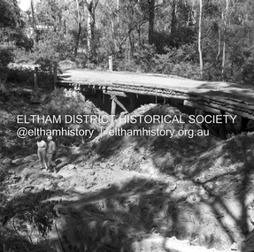
Negative - Photograph, J.A. McDonald, Henley Road at Watsons Creek, Apr. 1961
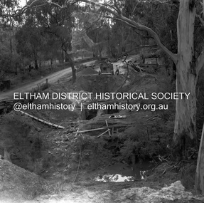
Henley Road at Watsons Creek looking easterly along centreline from west abutment Early April 1961Record of various Shire of Eltham infrastructure works undertaken during the period of 1952-1962 involving bridge and road reconstruction projects, sometimes with Eltham Shire Council Project Reference numbers quoted. It was during this period that a number of significant improvements were made to roads and new bridges constructed within the shire that remain in place as of present day (2022). In many situations, the photos provide a tangible visible record of infrastructure that existed throughout the early days of the Shire. The album was put together by or under the direction of the Shire Engineer, J.A. McDonald.infrastructure, shire of eltham, bend of islands, cr. charis pelling, henley road, henley road bridge, kangaroo ground, oxley bridge, watsons creek, w.e. wolf, bridge construction, road construction, 1961-04 -
 Eltham District Historical Society Inc
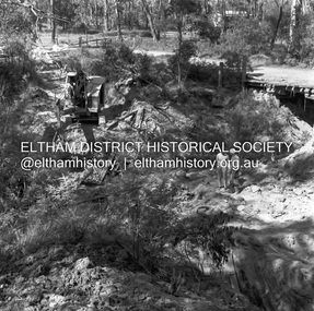
Negative - Photograph, J.A. McDonald, Henley Road at Watsons Creek, Apr. 1961
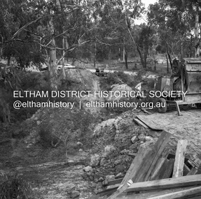
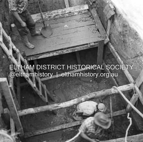
Henley Road at Watsons Creek showing excavation at western pier Rock at contract level, slight underground flow Early April 1961Record of various Shire of Eltham infrastructure works undertaken during the period of 1952-1962 involving bridge and road reconstruction projects, sometimes with Eltham Shire Council Project Reference numbers quoted. It was during this period that a number of significant improvements were made to roads and new bridges constructed within the shire that remain in place as of present day (2022). In many situations, the photos provide a tangible visible record of infrastructure that existed throughout the early days of the Shire. The album was put together by or under the direction of the Shire Engineer, J.A. McDonald.infrastructure, shire of eltham, bend of islands, cr. charis pelling, henley road, henley road bridge, kangaroo ground, oxley bridge, watsons creek, w.e. wolf, bridge construction, road construction, 1961-04 -
 Eltham District Historical Society Inc
Negative - Photograph, J.A. McDonald, Henley Road at Watsons Creek, Apr. 1961
Henley Road at Watsons Creek looking westerly along centreline from east abutment Early April 1961Record of various Shire of Eltham infrastructure works undertaken during the period of 1952-1962 involving bridge and road reconstruction projects, sometimes with Eltham Shire Council Project Reference numbers quoted. It was during this period that a number of significant improvements were made to roads and new bridges constructed within the shire that remain in place as of present day (2022). In many situations, the photos provide a tangible visible record of infrastructure that existed throughout the early days of the Shire. The album was put together by or under the direction of the Shire Engineer, J.A. McDonald.infrastructure, shire of eltham, bend of islands, cr. charis pelling, henley road, henley road bridge, kangaroo ground, oxley bridge, watsons creek, w.e. wolf, bridge construction, road construction, 1961-04 -
 Eltham District Historical Society Inc
Negative - Photograph, J.A. McDonald, Henley Road at Watsons Creek, Apr. 1961
Henley Road at Watsons Creek looking westerly showing west abutment excavation Mid April 1961Record of various Shire of Eltham infrastructure works undertaken during the period of 1952-1962 involving bridge and road reconstruction projects, sometimes with Eltham Shire Council Project Reference numbers quoted. It was during this period that a number of significant improvements were made to roads and new bridges constructed within the shire that remain in place as of present day (2022). In many situations, the photos provide a tangible visible record of infrastructure that existed throughout the early days of the Shire. The album was put together by or under the direction of the Shire Engineer, J.A. McDonald.infrastructure, shire of eltham, bend of islands, cr. charis pelling, henley road, henley road bridge, kangaroo ground, oxley bridge, watsons creek, w.e. wolf, bridge construction, road construction, 1961-04 -
 Eltham District Historical Society Inc
Negative - Photograph, J.A. McDonald, Heidelberg-Kinglake Road, 11 May 1961
Yow Yow Creek bridge 11 May 1961Record of various Shire of Eltham infrastructure works undertaken during the period of 1952-1962 involving bridge and road reconstruction projects, sometimes with Eltham Shire Council Project Reference numbers quoted. It was during this period that a number of significant improvements were made to roads and new bridges constructed within the shire that remain in place as of present day (2022). In many situations, the photos provide a tangible visible record of infrastructure that existed throughout the early days of the Shire. The album was put together by or under the direction of the Shire Engineer, J.A. McDonald.1961-05-11, heidelberg-kinglake road, infrastructure, bridge construction, shire of eltham, yow yow creek -
 Eltham District Historical Society Inc
Negative - Photograph, J.A. McDonald, General; Shire Offices, 1959
Shire of Lilydale, 15 Anderson Street, LilydaleRecord of various Shire of Eltham infrastructure works undertaken during the period of 1952-1962 involving bridge and road reconstruction projects, sometimes with Eltham Shire Council Project Reference numbers quoted. It was during this period that a number of significant improvements were made to roads and new bridges constructed within the shire that remain in place as of present day (2022). In many situations, the photos provide a tangible visible record of infrastructure that existed throughout the early days of the Shire. The album was put together by or under the direction of the Shire Engineer, J.A. McDonald.infrastructure, 1959, buttermans track, crosby property, creeks -
 Eltham District Historical Society Inc
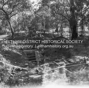
Negative - Photograph, J.A. McDonald, Laidlays Road, Arthurs Creek, April 1962
Bridge over Arthurs Creek Looking east April 1962Record of various Shire of Eltham infrastructure works undertaken during the period of 1952-1962 involving bridge and road reconstruction projects, sometimes with Eltham Shire Council Project Reference numbers quoted. It was during this period that a number of significant improvements were made to roads and new bridges constructed within the shire that remain in place as of present day (2022). In many situations, the photos provide a tangible visible record of infrastructure that existed throughout the early days of the Shire. The album was put together by or under the direction of the Shire Engineer, J.A. McDonald.1962-04, arthurs creek, bridge construction, infrastructure, laidlays road, shire of eltham -
 Eltham District Historical Society Inc
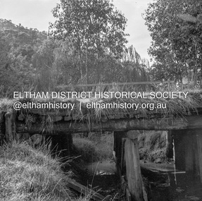
Negative - Photograph, J.A. McDonald, Henley Road Bridge at Watsons Creek, c. May 1962
Completed early January 1962Record of various Shire of Eltham infrastructure works undertaken during the period of 1952-1962 involving bridge and road reconstruction projects, sometimes with Eltham Shire Council Project Reference numbers quoted. It was during this period that a number of significant improvements were made to roads and new bridges constructed within the shire that remain in place as of present day (2022). In many situations, the photos provide a tangible visible record of infrastructure that existed throughout the early days of the Shire. The album was put together by or under the direction of the Shire Engineer, J.A. McDonald.1962-05, bend of islands, bridge construction, henley road, henley road bridge, infrastructure, kangaroo ground, oxley bridge, road construction, shire of eltham, watsons creek -
 Eltham District Historical Society Inc
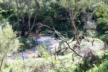
Photograph, Peter Pidgeon, Diamond Creek near Main Road Bridge, Eltham South, 8 Sep. 2021
Evidence of flooding from recent winter and early spring rainBorn Digitaleltham south, diamond creek trail, diamond creek (creek), floods -
 Eltham District Historical Society Inc
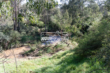
Photograph, Peter Pidgeon, Diamond Creek near Main Road Bridge, Eltham South, 8 Sep. 2021
Evidence of flooding from recent winter and early spring rainBorn Digitaleltham south, diamond creek trail, diamond creek (creek), floods -
 Eltham District Historical Society Inc
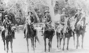
Photograph, Diamond Creek Mounted Scouts; Scoutmaster McWiggan second from right with his brother first on right, 1920s
Photo sourced from J. Sinclair reproduced on p61 of The Diamond Valley Story by Dianne H. Edwards, Shire of Diamond Valley 1979. "During the 1920s Diamond Creek had the only mounted scouts in Australia and only one other troop since, at Alice Springs in the 1940s, has ever used horses. Scoutmaster McWiggan is second from right with his brother first on right."Black and white copy of photo printed on glossy photographic paper 30.5 x 40.5 cm (12 x 16 inch); image size approx. 18.5 x 28 cmdiamond creek mounted scouts, diamond valley story, groups, horse, scoutmaster mcwiggan, scouts -
 Lorne Historical Society
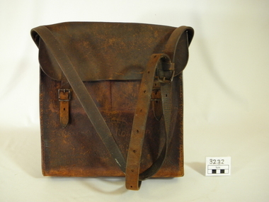
Functional object - Bag, circa1925
... the Govenor of Victoria, Lord Stradbroke, Grassy Creek... Stradbroke, Grassy Creek and "The Springs". Mr W D McKay first toll ...One of the toll bags used to collect tolls on the Great Ocean Road. First "Toll Gate" at Sunnymeade Estate as the road went through land owned by Mr C J Lane. Toll gates followed at "Stradbroke Point",later changed to "Stradbroke Knoll" named after the Govenor of Victoria, Lord Stradbroke, Grassy Creek and "The Springs". Mr W D McKay first toll keeper, then Mr & Mrs Wright. Toll commenced circa 1925 and ended 2nd October 1936. Cars were charged at 2/6 for car and driver and 1/- for each passenger. Motor cycles 2/-. Brown leather bag, with adjustable shoulder strap for carrying. Enclosed with a flap done up by 2 buckles.Hand scratched on front of bag:-"GREAT OCEAN ROAD TRUST".leather bag, toll gates, toll keepers, great ocen road -
 Lorne Historical Society
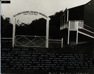
Photograph, Great Ocean Road. Tollgate and house
... Grassy Creek to the Springs at Cathedral Rock in October 1929... Gatekeepers were Mr and Mrs MacKay. They left Grassy Creek ...The toll gate and house was erected at Stradbroke Knoll, Grassy Creek by JC Taylor and sons of Geelong . Construction was completed on Christmas Day 1922. It was moved from Grassy Creek to Cathedral Rock in October 1929 where it stayed until 1936. It was then sold and moved to Lorne. It is the second house on the right in Minapre Street. The Gatehouse keepers at the time were Mr and Mrs Wright. The original Gatekeepers were Mr and Mrs MacKay. They left Grassy Creek with their family on 11 May 1926The GOR Tollgate and house were originally erected by J.C. Taylor and Sons of Geelong, at Stradbroke Knoll, Grassy Creek and construction was completed on Christmas Day 1922. It was moved from Grassy Creek to the Springs at Cathedral Rock in October 1929 where it stayed until 1936, It was then sold and moved to Lorne. It is the second house on the right in Minapre Street. The gatehouse keepers at this time were Mr. & Mrs.Wright. The original gatekeepers were Mr & Mrs Mackay. They left Grassy Creek with their family on 11th May 1926j.c. taylor and sons. gor, tollgate. -
 Lorne Historical Society
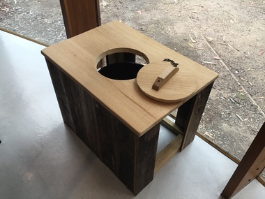
Functional object - Thunderbox, Circa 1930’s
The Great Ocean Road was built by World War 1 returned servicemen. Tolls were collected as sections of the road were completed. The first toll house was at Grassy Creek. It operated from 1922 to 1932 when it was moved to The Springs at Cathedral Rock about 5 km east of Lorne. The thunderbox is believed to have been used here at sometime between 1932 and 1936This is a rare archeological find. Items n this location are often damaged by the action of the sea and salt air. It is intimately associated with the early years of the development of the Great Ocean Road and the daily life of the workers. It is a typical example of the type of toilet used at the time. This reclaimed timber thunder box is enclosed on three sides. There is a circular hole on the top with a wooden handled lid attached by a chain. Inside is a steel can.great ocean road construction, returned sevicemen world war 1, great ocean road toll houses, toilet -
 Halls Gap & Grampians Historical Society
Photograph - B/W, C 1882
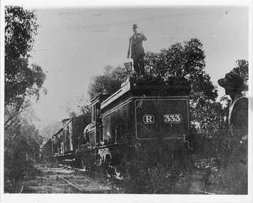
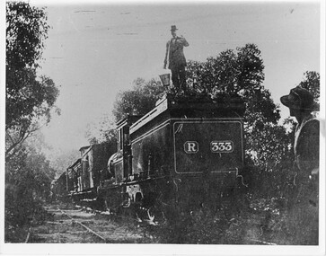
Occasional picnic trains took large groups of visitors to the base of the mountain range & sometimes as far as the quarry. Other journeys terminated at Fyans Creek station on the south side of Mt Dryden. Most trips were Sunday School & Church outings, some on the annual Good Friday picnic. Spring was also a popular timePhoto shows train at siding. Man standing on engine roof with bucket in hand; woman in right hand corner of photo looking on; passenger looking out of open doorway. R333 written on back of engine car. Engine turned back to fronttransport, trains -
 Halls Gap & Grampians Historical Society
Photograph - B/W, C 1882
Occasional picnic trains took large groups of visitors to the base of the mountain range & sometimes as far as the quarry. Other journeys terminated at Fyan's Creek station on the south side of Mt. Dryden. Most trips were Sunday School & church outings - some on the annual Good Friday picnic day. spring was also a popular time.Photo shows train at siding. Man standing on engine roof with bucket in hand; woman in right-hand corner looking on; passenger standing at open carriage door. R 333 written on back of engine car. Engine turned back to front.transport, trains -
 Eltham District Historical Society Inc
Photograph, Liz Pidgeon, Heritage Excursion; Maroondah Aqueduct, 3 September 2016, 3 September 2016
Newsletter No., 229, August 2016 Heritage Excursion - Maroondah Aqueduct Walk - Saturday 3rd September The Maroondah Aqueduct was once a major link in Melbourne’s water supply system. It was built between 1886 and 1891 to transfer water from the Watts River near Healesville to the Preston Reservoir. It was 66 km in length, made up of 41 km of open channel, 10 km of tunnel through hills and 15 km of pipeline across stream valleys known as inverted siphons. The section of the aqueduct through the Eltham area has been abandoned since the 1980s but the open channel has largely been retained. A recreational path follows the aqueduct reserve. For our excursion on 3rd September we intend to walk along the section of the aqueduct adjacent to Allendale Road. This is a section not visited on previous excursions and includes the transition from open channel to the inverted siphon across the Diamond Creek valley. Apart from the aqueduct itself the main feature of the walk is the extensive views across Eltham North and Diamond Creek. Along the way we will talk about the history of the aqueduct and the area. This easy walk is about 3 km return and will take 2 to 2.5 hours. It will start at 2pm at the junction of Allendale Road with Godber Road and Zig Zag Road North, officially Diamond Creek, but on the northern boundary of Eltham. (Melway ref.12 B10). Born Digitalmaroondah aqueduct, eltham north, activities, eltham district historical society, heritage excursion, aqueduct trail, spring -
 Eltham District Historical Society Inc
Photograph, Liz Pidgeon, Heritage Excursion; Maroondah Aqueduct, 3 September 2016, 3 September 2016
Newsletter No., 229, August 2016 Heritage Excursion - Maroondah Aqueduct Walk - Saturday 3rd September The Maroondah Aqueduct was once a major link in Melbourne’s water supply system. It was built between 1886 and 1891 to transfer water from the Watts River near Healesville to the Preston Reservoir. It was 66 km in length, made up of 41 km of open channel, 10 km of tunnel through hills and 15 km of pipeline across stream valleys known as inverted siphons. The section of the aqueduct through the Eltham area has been abandoned since the 1980s but the open channel has largely been retained. A recreational path follows the aqueduct reserve. For our excursion on 3rd September we intend to walk along the section of the aqueduct adjacent to Allendale Road. This is a section not visited on previous excursions and includes the transition from open channel to the inverted siphon across the Diamond Creek valley. Apart from the aqueduct itself the main feature of the walk is the extensive views across Eltham North and Diamond Creek. Along the way we will talk about the history of the aqueduct and the area. This easy walk is about 3 km return and will take 2 to 2.5 hours. It will start at 2pm at the junction of Allendale Road with Godber Road and Zig Zag Road North, officially Diamond Creek, but on the northern boundary of Eltham. (Melway ref.12 B10). Born Digitalmaroondah aqueduct, eltham north, activities, eltham district historical society, heritage excursion, acqueduct trail, spring -
 Eltham District Historical Society Inc
Photograph, Hume and Hovell Monument, Seven Creeks, Euroa (29.12.1824), Spring Excursion, Hume and Hovell's 1824 expedition (Part 2), 26 October 1997, 26/10/1997
... and pleasurable. activities hume and hovell monument Euroa Seven Creeks ...[article by Diana Bassett-Smith in EDHS Newsletter No. 117, November 1997:] MONUMENT HUNTING THE HUME AND HOVELL WAY - Sunday October 26 1997 dawned bright and very warm. Some twenty-five members, complete with picnic baskets, met outside the Eltham Library awaiting the Cobb and Co. large coach which would be taking us on the second leg of our travels along the route of the early explorers Hume and Hovell. Stephen West was our very good driver for the day. He would be guided around the circuitous route by Russell Yeoman who had made a detailed study, not only of the intended route, but of the story of these two explorers. During the trip Russell regaled us with poetry, quotations from the Journals and the History of the Shire of Seymour, "The New Crossing Place" by Martindale, 1982, (now Mitchell Shire due to the recent amalgamations). We headed towards the Hume Highway via Greensborough and Cooper Street and proceeded north to our first stop, noting on the way Monument Hill in the distance which is near Kilmore and, according to Russell, well worth the effort to visit as the view across the valley is magnificent. Past Sunday Creek Valley, Mt Piper and Mt Disappointment, all traversed and noted and named by them. We passed through Tallarook, then onto Seymour where we took photos of the monument telling us that Hume and Hovell had passed through on the 28th of October 1824. We also deviated down Hume and Hovell Road viewing deer and emu farming and the Bellbourie property now a sanctuary. Leaving Seymour behind we travelled up the Avenel Road to the Avenel monument, pyramidal in design of four reducing square blocks with a sharply pointed peak, erected in 1924 in memory of the 1824 exploration. The day was warming up and the countryside showing the dryness of the current drought. A parallel note had been made in their journal too of 1824 of the drought appearance of the country they were traversing. At Seven Creeks, Euroa we stopped for some minutes to check the monument placed 20th November 1924 to commemorate their passage on the 29th December 1824. More photos. Russell had pointed out the abrupt termination of the distant ranges which is noted in their journal. The next monument is beside the road at the entrance to Honey Suckle Creek Caravan Park, Violet Town. The squarish shaped monument some eight feet high is topped with a simple steel cross, and was to mark the date of 28th December 1824 and built for the 20th November 1924. By now it was 12.20 and nearly lunchtime as we drove along the Warranbayne Road to Roach's Road, monument hunting without success. Though there is a large, what appears to be an old timber sign which was hard to read, maybe this was the lost monument. In many of the paddocks hay had been cut and baled or was being cut, what a contrast to the rugged country they had passed through which was smoky from the fires of the natives burning off. By 1.00 pm we were at Benalla and pulled up beside the park where abundant beds of roses filled the air with their scent and the smell of barbecued food twitched the nostrils whilst the cheerful sounds of other picnickers could be heard throughout the park. We left the bus and collected up our picnics, dispersed to the various tables and enjoyed the shade from the various European trees. 2.00 pm and we were on the road again driving along the Benalla, Mansfield, Yea road. The Swanpool monument states that they passed four miles south and returned three miles north. Then we stopped at the Barjarg monument which notes that they camped near this spot. It is again a pyramidal monument and this time topped with a steel arrow indicating their route of the 29th November 1824. Half an hour later we came to another monument, again with a steel arrow marker on top and the plaque dated the 2nd of 12th 1824. Erected on the 12th of 12th 1924. "They blazed the way that we might inherit the land." Another square based and needle topped monument appeared at Yarck near Yea and this plaque records the date of 3 December 1824. Near McGuigans Road Russell related that the expedition had lost a dog but it had found them next day, the dog was apparently torn by a kangaroo. A short while later Russell reminded us here of the problems they encountered in crossing the Goulburn River near Molesworth where banks were high, water deep and wide. "Good coat of grass but quite dry due to drought". At Yea we stopped for afternoon tea and raided the last of our picnics and looked at the monument to their journey of 1824, situated at a corner of the gardens near the bowling green. No photo – we were out of film. We returned home via Kinglake West and Whittlesea past the Yan Yean Reservoir, not full. 5.00 pm back at Eltham we emptied out of the bus and everyone, including Joan Cole, collected their things, Joan also had the major souvenir of the day, a large carp she had picked up from the river bank, her cat was in for a great feast. The day was made so interesting by the informed commentary which Russell provided. His background knowledge of the route and nature of the journey could only have come from many hours of reading and driving the area. Thank you to Russell and to everyone who made the day so informative and pleasurable. Colour photographactivities, hume and hovell, monument, euroa, seven creeks -
 Marysville & District Historical Society
Document (Item) - Report, John F. Waghorn, Yarra Track, Unknown
A report on the history of the Yarra Track by John Waghorn, a local amateur historian.A report on the history of the Yarra Track by John Waghorn, a local amateur historian. John Waghorn was an amateur historian, an authority on the history of Victoria's postal services. He could tell you how mail was delivered in the high country in the 1880s, where the town of Gobur was, or when the overland Melbourne-Sydney mail service began. He admitted that his hobby has got a little out of hand. He had 30 filing cabinets, and indexes of more than 70,000 postal workers over the past 160 years crammed into three rooms at his home. If an ancestor was a postmaster in a Victorian town, he may have been able to reveal the person's occupation, income and working conditions.yarra track, john waghorn, victoria's postal services, wood's point, sydney road, longwood, merton, mansfield, postmasters, bonnie doon, melville merton mansfield, eltham, healesville, marysville, walhalla, melbourne-warburton-wood's point line, loose bags, heidelberg post office, eltham post office, kangaroo ground post office, yarra glen post office, marysville post office, healesville post office, mansfield post office, jamieson post office, gaffney's creek post office, wood's point post office, postal department, george rieck, stockman, jones, beecher, stockman's reward, big river, mary mcdonald, upper yarra river, donovan's creek, cornelius donovan, bridget buggy, matlock, alexandra, william farrell, jordan diggings, new chum, watts river, black spur, narbethong, granton, acheron river, mount strickland, paradise plains, mount grant, mount arnold, jordan goldfields, william robley, robley's spur, big river crossing, great dividing range, cumberland valley, james mcguigan, w elliot, christopher harrison, james marsh, cobb and co, box hill, lilydale, fehrings, koehlers, shaws, bear creek, cairnsville, cumberland creek, walkers, golden bower mine, collins' mountain home hotel, walsh's creek post office, rosa mcveigh, frank barton, hitchins, matthew kennedy, william morris, e r nichols, t woods, tom burchell, peter kerr, henry kuyper, william podlech, george koehler, henry brockmann, henry petty, thomas smith, jacob butchart, john perry, slingsby davis, royal mail hotel, walter gray, john summers, travellers rest hotel, lockington, the oaks, the springs, st clair, thomas crawford, springvale hotel, john sinclair, saint clair hotel, gould, mathews, willie we have missed you hotel, germany, johan fehring, adelaide, linton, ballarat, gunbower, murray river, anna katerina fehring, 1890s depression, land boom, fehring place, fred baker, alf sparke, fehring's hotel, mcveigh's hotel, wood's point mountaineer, l cox, victorian country directories, letson cox, coburg, maria hayes, setson, fitzroy, richmond, john cox, jordan river, jericho, e. norris, le poidevin, newell, o'brien, alhambra, sinclair, parker, ellis, tripp, quin, vernon, thompson, charsley, james fahie, george locke, william chester, chesterville, kirwan, cumberland reserve, blue spruce, e.s. and a bank, selby joyce, selby charles joy, selby joseph joyce -
Marysville & District Historical Society
Document (Item) - Document-Table, Judith Vimpani, Yarra Track Hostelries- Marysville to Woods Point, Unknown
... catherine baker john frederick baker mcmahon's creek oaks ...A document outlining all the hostelries that existed along the Yarra Track between Marysville and Wood's Point.A document outling all the hostelries that existed along the Yarra Track between Marysville and Wood's Point.yarra track, marysville, wood's point, woods point, fernshaw, paradise plains, black spur, mount grant, george edwards, walker family, melbourne, new chum, hit & miss restaurant, mr clifford, michael woods, glen watts, tri bhean hotel, ewen cameron, ewen hugh cameron, thomas barton, butler's wood's point directory, globe hotel, swanston street, mount juliet, ben more & c, jordan district, jefferson's watts bridge inn, matthew jefferson, reefer's hotel, boyle's hotel, william henry johnson, samuel boyle, black spur hotel, fisher's creek, narbethong, fisher's home hotel, black spur inn, frederick fisher, william hodson, wood's point road, acheron river, acheron bridge hotel, john robson, granton, clifford, wilks creek, wilks creek hotel, patrick maloney, steavenson, marysville hotel, australian hotel, junction hotel, the dutchman's restaurant, henry kuyper, william podlech, mount arnold, mount arnold hotel, charles schultz, james toohey, john gleeson, joy burchall, ian newman, henry brockman, belle isle, belle elle, bellell creek, upper yarra, guerin's bridge, bell's hotel, henry petty, celia moran, ruth petty, cumberland creek, cumberland creek store and restaurant, cumberland creek hotel, charles edwin hargreaves, annie hargreaves, urina hargreaves, alice hargreaves, healesville, josiah hargreaves, henderson drysdale, henry whelan, halfway house, thomas smith, svendson, gosling, donovans creek, chesterville, perry's hotel, john perry, perry's coach and horses hotel, edward courtney, scandinavian hotel, the swede's, walker's hotel, jacob burchart, golden fleece, theodore kappler, george koehler's hotel, david walker, millicent walker, elsie jowett, bill walker, big river, royal mail hotel, shaw's, slingsby davies, edwin jones, elizabeth jane parker, sandridge, archibald charles edwin jones, matlock, alexander myers, frank berwick frederick jones, ned jones, jennie jones, sophie milllicent parker jones, thomas shaw, dorothy walker, travellers rest hotel, reefton, summers, john fehring, f fehring, katerina fehring, john christoph blumeyer, anne fehring, john baker, evelyn observer, anna katrina baker, hannah catherine baker, john frederick baker, mcmahon's creek, oaks, the springs, st clair, sinclair's valley, mountain home hotel, neilson, collins, waters, jan emma sinclair, john sinclair, mr cox, peter sinclair, willie we have missed you hotel, spring vale hotel, robert matthews, thomas crawford -
 Glen Eira Historical Society
Document - Melbourne and Metropolitan Board of Works
This file contains five items relating to Caulfield Council Visits with the Melbourne & Metropolitan Board of Works (MMBW) from 1919 to circa 1974: 1/A photo album containing photos from the MMBW ‘visit to the Headworks, Yan Yean Water Supply, Wallaby and Silvery Creeks’ from 28/02/1919 to 03/03/1919, attended by members of the Caulfield City Council. The album contains 13 original black-and-white photographs, 3 of which are of the council members. The album is accompanied by a report by Felicitie Campbell, written 11/2008, about these visits. 2/A publication from the MMBW documenting its review of operations for 1973-1974. The report contains information about water supply, sewerage and drainage infrastructure completed or in progress during this period including infrastructure in Caulfield, Ormond, Carnegie and Bentleigh. 3/A periodical feature from the MMBW titled ‘Living City’, issue no. 16, Spring/Summer 1974. Included in the article titled ‘Program’ is a notice that construction will continue on the Elster Creek drain from Thomas St. to Wheatley Road, McKinnon. The periodical also includes the names of commissioners W. R. Walters from Caulfield and G. R. Bricker from Moorabbin (back cover). 4/2 maps and 1 information booklet from the Thomson Project Open Day attended by Felicite and John Campbell as representatives of the Caulfield City Council. This was an annual MMBW open date. Date unknown. 5/Resarch notes by Kate Aldred about the photo album and Thomson Project Open Day booklet and their links to Felicite Campbell 01/04./2014.koornang road, draper street, hall street, centre road, brewers road, caulfield intercepting sewer, byron street, caulfield park, elster creek, caulfield, carnegie, ormond, bentleigh, thomas street, brighton east, wheatley road, mckinnon, city of caulfield, bricker g. r., walters w. r., caulfield city council, melbourne and metropolitan board of works, hall councillor, murray councillor, murphy councillor, wharington councillor, phillips councillor, blyth councillor, best robert sir, reid doctor, jowett mr., wooley mr., hindle mr., annual reports, water supply structures and establishments, sewerage and sanitation, sewerage establishments, drainage, town planning, business and finance, councillors, mayors, acqueducts, dams and reservoirs, creeks, waterfalls, rivers, construction sites, north road, north road pumping station, cities and towns, campbell felicitie