Showing 285061 items
matching streets,roads,melbourne,map,melway
-
 Ringwood and District Historical Society
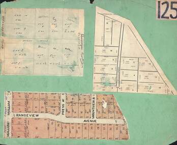
Card, Collage of Residential Subdivision Map Clippings - Ringwood, Victoria - (Undated)
Three maps mounted on green cardboard - Hand-drawn map of residential allotments off Warrandyte Road in Milne Road and Berringa Road Park Orchards. Map with acres roods and perches measurements of allotments in Canterbury Road and Miller Street Heathmont. Clipping from a land sale brochure with street names not existing together in the area - Rangeview Avenue, Press Avenue and Mountview Avenue. -
 City of Greater Bendigo - Civic Collection
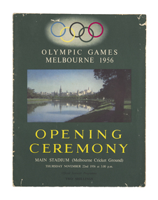
Programme, Melbourne Olympic Committee, Opening ceremony : Olympic Games, Melbourne 1956, main stadium (Melbourne Cricket Ground) : Thursday November 22nd 1956 at 3.00 p.m, 1956
Held in Melbourne from the 22nd November to 8th December, the 1956 Summer Olympics, officially known as the Games of the XVI Olympiad or the Melbourne Olympics were the first held outside of Europe or the USA. This programme is a comprehensive guide to the opening ceremony and includes names of the organising committee and general information about the history of the Games.Colour printed programme. 31 pages, 2 unnumbered pages, illustrated, with maps. Front cover photograph of the Yarra River looking towards Melbourne CBD. Olympic rings at top of page. Stapled at fold.melbourne olympic games, olympic games 1956, city of bendigo tourism -
 Melbourne Tram Museum
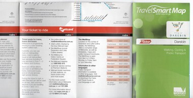
Map, Department of Transport, "TravelSmart Map - Darebin", Jun. 2010
Map - pocket - 28 fold - showing walking, cycling and public transport in the City of Darebin, using a Melway Map base along with public transport information, Metcard, cycling and walking groups. Produced by the Dept of Transport June 2010.trams, tramways, city of darebin, maps, public transport, metcard, metlink -
 Bacchus Marsh & District Historical Society
Map, Coimadai Parish Map, County of Bourke. Circa 1890s-1900s
The cadastral Parish of Coimadai, a subdivision of the County of Bourke, lies directly north of the township of Bacchus Marsh. The date of this map is uncertain. T.F. McGauran the person who made a photo-lithographic copy of the map was in charge of photo-lithography at the Victorian Department of Lands and Survey in the late 19th century until about 1910.A single page paper map showing the map for the Parish of Coimadai in the County of Bourke. A cadastral map showing parish boundaries and land ownership. A rectangle shaped area is missing from the centre of the map due to a tear or deliberate excision. The map is pasted into a bound volume containing 76 maps or plans in total. High resolution digital image stored on BMDHS computer network. Photo-lithographed at the Department of Lands and Survey, Melbourne by T.F. McGauran 26.8.[??] NOTE. Photo litho from L.P showing temporary surveys and occupation of land prepared for departmental use onlybacchus marsh region parish plans, coimadai parish maps, coimadai parish plan -
 Parks Victoria - Mount Buffalo Chalet
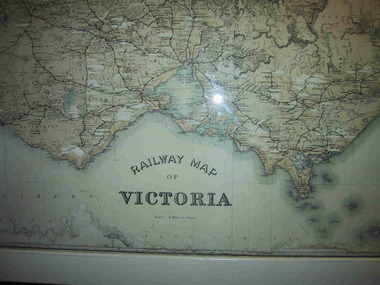
Map, "Railway Map of Victoria"
Large framed map of Victoria, showing Victorias extensive rail network. Printed by Victorian Railways and is one of a number of 'framed pictures, particularly photographs of scenery, which have always been a feature of the Chalet.' (Pg 83. Historica, 2011) This map has been a permanent fixture situated in the hallway alongside the ballroom leading to the ski hire area since the 1950's and most likely earlier. Listed in Draft Inventory of Significant Collection ItemsLarge railway map of Victoria, Melbourne & Ballarat framed in white painted wood. Scale eight miles to one inch. Areas of the map have been whited out.Yes -
 Kew Historical Society Inc
Plan, Melbourne & Metropolitan Board of Works : Borough of Kew : Detail Plan No.1565, 1905
The Melbourne and Metropolitan Board of Works (MMBW) plans were produced from the 1890s to the 1950s. They were crucial to the design and development of Melbourne's sewerage and drainage system. The plans, at a scale of 40 feet to 1 inch (1:480), provide a detailed historical record of Melbourne streetscapes and environmental features. Each plan covers one or two street blocks (roughly six streets), showing details of buildings, including garden layouts and ownership boundaries, and features such as laneways, drains, bridges, parks, municipal boundaries and other prominent landmarks as they existed at the time each plan was produced. (Source: State Library of Victoria). This plan forms part of a large group of MMBW plans and maps that was donated to the Society by the Mr Poulter, City Engineer of the City of Kew in 1989. Within this collection, thirty-five hand-coloured plans, backed with linen, are of statewide significance as they include annotations that provide details of construction materials used in buildings in the first decade of the 20th century as well as additional information about land ownership and usage. The copies in the Public Record Office Victoria and the State Library of Victoria are monochrome versions which do not denote building materials so that the maps in this collection are invaluable and unique tools for researchers and heritage consultants. A number of the plans are not held in the collection of the State Library of Victoria so they have the additional attribute of rarity.Original survey plan, issued by the MMBW to a contractor with responsibility for constructing sewers in the area identified on the plan within the Borough of Kew. The plan was at some stage hand-coloured, possibly by the contractor, but more likely by officers working in the Engineering Department of the Borough and later Town, then City of Kew. The hand-coloured sections of buildings on the plan were used to denote masonry or brick constructions (pink), weatherboard constructions (yellow), and public buildings (grey). MMBW Plan No.1565 is an example of a plan where a number of streets have been created since the area was surveyed, or in other cases renamed. The plan shows those streets that were bordered by Ross Street, Mount Street, Sackville Street and Burke Road. Since 1905, Mawson Street has been created and Mont Albert Road renamed as Dean Street. Named houses on the plan include ‘Tyrol’, ‘Glengorse’, ‘Theodore Villa’, ‘Arncliffe’, ‘Ballynira’ and ‘Hazeldene’. The plan also shows a Wesleyan Church in Sackville Street. In 1883, the Church’s Sunday School celebrated its silver anniversary.melbourne and metropolitan board of works, detail plans, mmbw 1565, cartography -
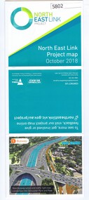 Greensborough Historical Society
Leaflet, North East Link Authority, North East Link: project map October 2018, 2018_10
North East Link Authority was set up to lead development of this project. This map shows the proposed route with major intersections/interchanges. Map, colour text and images.north east link -
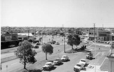 City of Kingston
Photograph - Digital image, Black and white, Roads - Junction of Nepean Highway and South Road, c. 1950
... Roads - Junction of Nepean Highway and South Road ...Junction of Nepean Highway and South Road, Moorabbin - Moorabbin Hotel on right. Shops in centre demolished for road widening in 1980'sBlack and white image of Nepean Highway and South Road junction point of view from Kingston Town HallPrinted in black text a round white sticker: 234 Handwritten in red ink 80% Yellow post it note written in blue ink: CHAP 7 234 / - Nepean Hwy + South Roadnepean highway, south road, moorabbin, moorabbin hotel -
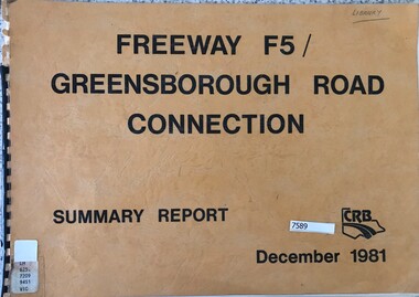 Greensborough Historical Society
Book - Report, Country Roads Board, Freeway F5 / Greensborough Road connection. December 1981, Summary Report, 1981_
... Country Roads Board ...Summary report of the Country Roads Board's 1981 proposals for the F5 Freeway (now Metropolitan Ring Road) between Dalton Road and Diamond Creek Road and the duplication of Greensborough Road (Greensborough By-pass).Historic proposal for roads in the Greensborough area51 pages, text, colour maps. Plastic binding.country roads board, greensborough bypass, metropolitan ring road, greensborough road -
 Merri-bek City Council
Acrylic on watercolour paper, Mandy Nicholson, Cultural Map of Melbourne, 2003
Primarily a painter, Mandy Nicholson also produces ceramics, carvings, murals, prints, designs and children’s clothing. Born in 1975, Nicholson was raised in Healesville and belongs to the Wurundjeri-willam (Woiwurrung language) clan of the Kulin Nation. Mandy’s paintings often represent important cultural rituals and are executed in her distinct graphic style using the traditional motifs of her people blended with contemporary interpretation. Cultural Map of Melbourne shows significant sites across Melbourne. These include scar trees, corroboree trees, stone quarries, bush tucker sites, significant rivers, fresh water wells and traditional campsites. -
 Kew Historical Society Inc
Map, Real Estate Map of Bulleen, Templestowe, Lower Templestowe, Doncaster, North Balwyn
A large undated printed map of Bulleen, Templestowe, Lower Templestowe, Doncaster, North Balwyn showing major and minor roads, waterways and proposed facilities in this area of Melbourne.A useful if undated real estate map that allows viewers to compare current and historic aspects of these areasMap of Bulleen, Templestowe, Lower Templestowe, Doncaster, North Balwyn used by JB Thomson & Co, Real Estate Agents, to identify and record land sales on these. There are some markings on the plan indicating the location and price of lots.subdivision plans, bulleen, templestowe, lower templestowe, doncaster, north balwyn -
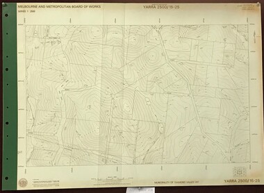 Greensborough Historical Society
Map, Melbourne and Metropolitan Board of Works. Survey Division, MMBW, Yarra 2500 / 15.25. Yarrambat, Black Gully Road, 1978_07
Melbourne and Metropolitan Board of Works. Yarra 2500 [base map] 15.25. Yarrambat, Black Gully Road. Municipality of Diamond Valley 257. Prominent streets include: Black Gully Road, Ironbark Road and Murray Road. MMBW Map in 1:2500 [scale] series. Cream parchment with green tape reinforcing on edges and punched holes on left edge.mmbw, melbourne and metropolitan board of works, shire of diamond valley, yarrambat - maps -
 Whitehorse Historical Society Inc.
Map, Melbourne Metropolitan Area Base Map, 1957?
Sheet 254 of part of the Municipality of Nunawading and part of the Parish of Nunawading, showing roads, block numbers, creeks and contours mostly south of Canterbury Road.Sheet 254 of part of the Municipality of Nunawading and part of the Parish of Nunawading, showing roads, block numbers, creeks and contours mostly south of Canterbury Road. Prep. from State Aerial and Cadastral survey information, August 1957. Scale: 400 ft = 1 inchSheet 254 of part of the Municipality of Nunawading and part of the Parish of Nunawading, showing roads, block numbers, creeks and contours mostly south of Canterbury Road. city of nunawading, cadastral -
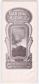
 Marysville & District Historical Society
Map (Item) - Tourist Map, Department of Lands & Survey, Tourist's Map of Narbethong and Marysville Districts Victoria, 1913
A tourist map for the Narbethong and Marysville Districts that was originally produced by the Department of Lands & Survey in 1925.A tourist map for the Narbethong and Marysville Districts that was originally produced by the Department of Lands & Survey in 1925.Reprint of the 1925 Tourist brochure by permission R.E. Holmes Surveyor General By Authority: ALBERT J. MULLETT, Government Printer, Melbourne. Photo Lithographed at the Department of Lands and Survey Melbourne by W.J. Butson/ 26.8.13narbethong, marysville, victoria, department of lands & survey, the acheron valley, warburton, map, tourist map -
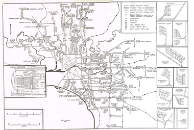 Melbourne Tram Museum
Map, Track plan or track map or layout of the Melbourne system, c1973
Track plan or track map or layout of the Melbourne system showing track layout, crossovers, depots, workshops and route numbers, terminus, substations, Bundy clocks, layout of Preston works. On the rear is a detailed layout of the city area. Shows railway stations but not the station names and rivers. Printed on cartridge paper. No details of to who prepared the plan or the drawing or date. Wattle Park line has been duplicated (Sept 1970), but the Essendon Airport line remains (closed Oct. 1976).trams, tramways, mmtb, track layout, junction, depots, substation, plans, trackwork, route numbers, terminus, map, bundy clock -
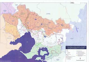 Greensborough Historical Society
Maps, Greater Melbourne Water Authority, Municipality and Registered Aboriginal party Boundaries, 18/07/2018
Shows Melbourne Water and Municipal area boundaries, with boundaries of registered aboriginal parties, in central Victoria.Printed in colour one sideMap reference 20180746aborigines victoria, water supply, melbourne water -
 Melbourne Tram Museum
Document - Memorandum, Melbourne & Metropolitan Tramways Board (MMTB), Parade of RAN personnel through city streets, 8/02/1946 12:00:00 AM
... Parade of RAN personnel through city streets ...Parade of RAN personnel through city streets Friday 8 February 1946 Letter from HS Wootton, Town Clerk, City of Melbourne, describing arrangements for the parade. Letter from W Simpson Assistant Manager to officers concerned. 5 memos from JM Harry, Dist Traffic Supt SS regarding tram arrangements to various inspectors. Memo dated 4th February 1946.Notations written in pencil on several memos.trams, tramways, events, port melbourne, port melbourne depot, hanna st depot, malvern depot, glenhuntly tram depot, camberwell depot -
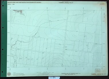 Greensborough Historical Society
Map, Melbourne and Metropolitan Board of Works. Survey Division, MMBW, Yarra 2500 / 14.27. Yarrambat, Youngs Road, 1977_09
Melbourne and Metropolitan Board of Works. Yarra 2500 [base map] 14.27. Yarrambat, Youngs Road. Municipalities of Diamond Valley 257 and Whittlesea 239. Prominent streets include: Youngs Road, Ashley Road and Yan Yean Road. MMBW Map in 1:2500 [scale] series. Cream parchment with green tape reinforcing on edges and punched holes on left edge.mmbw, melbourne and metropolitan board of works, shire of diamond valley, whttlesea, yarrambat - maps -
Port Melbourne Historical & Preservation Society
Pamphlet - South Melbourne - Port Melbourne Historical & Preservation Society, "A walk around Port Melbourne", c. 1980
South Melbourne - Port Melbourne Historical & Preservation Society was in operation from the 1970s for approximately 20 years1980s information pamphlet as a guided walk around Port Melbourne. Produced by the South Melbourne - Port Melbourne Historical and Preservation Society. Map on front cover ; pink paper.built environment, heritage, recreation, south melbourne - port melbourne historical & preservation society -
Port Melbourne Historical & Preservation Society
Document - 2011 Melway Greater Melbourne Street Directory, 2011
... streets ...2011 editions of Melway Greater Melbourne Street Directory Top quarter white, bottom blue background with photo of citybuilt environment, engineering - roads streets lanes and footpaths, natural environment, transport - roads, streets, mapping, greater melbourne -
 Greensborough Historical Society
Map, Map of Greensborough - Jessop's Real Estate, 1930c
This map of Greensborough hung in the office of Cec Jessop's Real Estate office corner Main and Grimshaw Street. Includes a word document listing street name changes from the original map to today, according to Norm Colvin.This map was saved from the building when the business closed.Canvas roll-up map with timber rails top and bottom.greensborough - maps, cecil jessop, greensborough street names -
 Warrnambool and District Historical Society Inc.
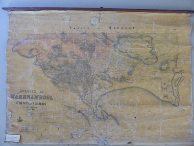
Mao, Borough of Warrnambool, County of Villiers, 1873
This is an early map of the Borough of Warrnambool (1872/3) showing the central town area of Warrnambool and the surrounding district. Reserves, public buildings and some businesses are marked. The map was photolithographed by John Noone, a Melbourne artist and photographer who claimed in 1858 to have the oldest-existing photographic studio in Melbourne. Photolithography was a process first developed in Melbourne. For several years Noone was the official photographer for the Victorian Crown Lands Office and for the Victorian Public Library and Museum. The map has the stamp of the seller of the map – Charles Hider, the well-known stationer and bookseller in Timor Street, Warrnambool. The owner of the map, Henry George Marfell, (1883-1962) was the son of John and Mary Ann Marfell. The Marfells were well-known in Warrnambool as grain merchants and managers of the Warrnambool Co-Operative Milling Company. It is surmised from the writing on the Marfell label that this map was at some stage given by Henry Marfell to the old Warrnambool MuseumThis map of early Warrnambool is of considerable significance, firstly because its original state and early date (1873) make it of antiquarian and historical interest. Also the connection with the names, Charles Hider and Henry Marfell and the old Museum gives it added provenance and interest.This is a wax paper map mounted on cloth. At the top it is attached by nails to a piece of wood and at the top it has a cloth ring for hanging the map. The map is in black shadings on a yellow background. The map is badly creased and coming away from the cloth at the edges and at other various points. There is some red or pink marking or staining on the township area of the map (originally the sold lands on this map were coloured in brown and the reserves, buildings, etc in pink). On the left hand corner there is a piece of paper glued on with some handwriting in ink (Marfell). There is also the stamp of the seller of the map – Charles Hider, stationer and bookseller, of Timor Street Warrnambool‘Early Map of W’bool, H.G. Marfell’ history of warrnambool, charles hider, henry marfell -
 Warrnambool and District Historical Society Inc.
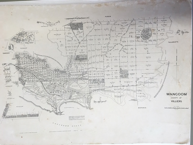
Document: Map, Map Wangoom County of Villiers, 1955
This map contains the names, acreage details and dates of the original property owners of the Parish of Wangoom (County of Villiers), excluding the township of Warrnambool. It also has details of the Crown Lands adjoining the Merri and Hopkins Rivers. This is a most important map as it has details on the original property owners. It is a most valuable research tool and is one of our most-used maps.This is a map, printed in black and white and mounted on cardboard. Where there was intensive land ownership the details have been reproduced in larger print on the margins of the map. There are scuff and dirt marks on the map but it is otherwise in good condition.‘Wangoom, County of Villiers’wangoom, warrnambool, county of villiers -
 City of Kingston
Pamphlet - Colour, Farrow Falcon Press, Printers, Ozone Estate, Bluff Road, Hampton, c.1940
Sales plan for land in the suburb of Hampton (Highett), bounded by Bluff Road, Wickham Road, Peterson Street and June Street. Includes Morley Street, Follett Avenue, and Parrett StreetThe developing urban area of Highett within the City of Kingston. This land sale pamphlet illustrates the subdivision of land within the municipality and the changing demographic of the district as new houses are constructed close to infrastructure.Colour pamphlet advertising for private sale the Ozone Estate, Bluff Road Hampton. Incorporates a map of the estate bordered by Bluff Road, Wickham Road, June Street and Peterson Street including Morley Street, Follett Avenue and Parrett Street.Handwritten in grey pencil on reverse: Ozone Printed in purple ink on front top right-hand corner: Vendors are - Leslie Harcourt MacGowan, Esq / Neerim Road, Caulfield / & / Arthur Alfred Parrett, Esq / 311 Flinders Lane / Melbourneland sales, estate, hampton, highett -
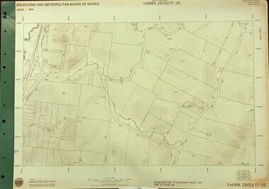 Greensborough Historical Society
Map, Melbourne and Metropolitan Board of Works. Survey Division, MMBW, Yarra 2500 / 17.25. Hurstbridge, 1978_01
Melbourne and Metropolitan Board of Works. Yarra 2500 [base map] 17-26. Hurstbridge. Municipalities of Diamond Valley 257 and Eltham 238. Prominent streets include: Silvan Road and Hurstbridge Road. MMBW Map in 1:2500 [scale] series. Cream parchment with green tape reinforcing on edges and punched holes on left edge.mmbw, melbourne and metropolitan board of works, shire of diamond valley, hurstbridge - maps -
![Borough of Kew - Gazetted Streets [1865-1937]](/media/collectors/550653872162f11fb04854aa/items/59614050d0cdd511a09c84a0/item-media/59614577d0cdd511a09e80c0/item-fit-380x285.jpg) Kew Historical Society Inc
Kew Historical Society IncDocument, Borough of Kew / Gazetted Streets, 1865-1937
... Borough of Kew / Gazetted Streets ...The Melbourne suburb of Kew gained independence from the Boroondara Roads Board in 1860, being declared a Municipality in that year. Kew became a Borough in 1863, a Town in 1910, and a City in 1921. The former City of Kew became part of a newly declared City of Boroondara in 1994. This very fragile document records the following information about streets in Kew - Name, Total Width, Width of Carriageway, Description, Government Gazetted - Year & Page.While the name of a street was formally acknowledged and published in the Victorian Government Gazettes, this document, compiled by a public officer, probably in the Town Clerk's Department, is the earliest known local record listing street names in the Borough, later Town, then City of Kew. The front page indicates that in 1865, the responsibility for an initial 36 streets in Kew was taken over by Council. The final annotation in the document was made in 1937. The document is an important record for researchers seeking to understand the dating of streets in the district.27-page document compiled by officers of the Borough, Town and City of Kew, listing the names of streets taken over by Council, and providing details of their proportions and gazettiing. The document covers the period of 1865 to 1937. Handwritten documentborough of kew, streets -- kew (vic.) -
 Echuca Historical Society
Map, Map of Township - Echuca
Map on white paper that has yellowed. Black print Handwriting is black but faded. In wooden frame behind glass. Printed Survyor's plan for Echuca Township, date 5th March 1855, from the Surveyor General Office. Melbourne March 5th 1855 Plan drawn by P Chauncey. Hand written- This plan is now a Port for the South Australian Steamer Trade - when Hopwood settled here/ it was only a wild bush - he is now throwing a bridge/ at his own cost across this river 200yards wide. signed by Henry Hopwood. Typed on backing paper: Plan of the township of ECHUCA dated March 1855, One month before the first land sales / Autographed by Henry Hopwood in Oct 1955. -
 Kew Historical Society Inc
Photograph, C Stuart Tompkins ARPS, Construction of Stawell and Yarra Streets, 1956
... Construction of Stawell and Yarra Streets ...Yarra Street in the Studley Park section of Kew was subdivided in the 1940s and 1950sSmall black and white photograph looking north-west down Yarra Street, Kew from upper Stawell Street during street construction in 1956. Homes at 32 Stawell Street and 5 Yarra Street are partially visible on left.yarra street (kew) -
Port Melbourne Historical & Preservation Society
Document - CD-ROM, Archive Digital Books Australia, Melbourne & Suburbs Street Directory 1936, 2011
"Melbourne & Suburbs Street Directory 1936" Plastic CD case with white and pale green insert. Policeman image and motorcar.Melbourne & Suburbs Street Directory 1936. Collinsengineering - roads streets lanes and footpaths, 1936, street directory