Showing 302 items
matching the proclaimers
-
 The Beechworth Burke Museum
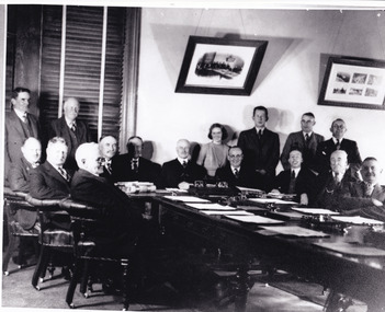
Photograph, Unknown c.1900s
This image depicts a group of local counsellors from the Shire of Beechworth (est. mid to late 1900s). The identities of those within the photo remain unknown. The table and chairs featured in the image were produced in the late 19th century and have been in continual use for more than 100 years. The councellors would likely have convened in the Beechworth Town Hall. A History of Beechworth: Gold was discovered in the May Day Hills district in 1852. A canvas and timber settlement soon developed as prospectors rushed to the area. Over four million ounces of gold was recovered in the first 14 years. Between 1852 and 1857, Beechworth was a gold-producing region and centre of government, boasting many industries and a multicultural population. Beechworth was proclaimed a borough on the 11th of September 1863, a formalisation of the municipal incorporation of the town seven years before. This image is associated with the history of Beechworth; it reveals the identities of local counsellors, persons whose contribution to the Beechworth Shire could otherwise be lost to time. Black and white rectangular photograph, unmounted.beechworth council, indigo shire, local victorian government -
 Flagstaff Hill Maritime Museum and Village
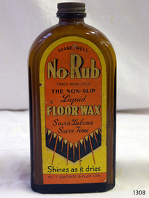
Container - Bottle, J R Alexander & Sons Ltd, c. 1936
This bottle labelled No Rub liquid wax proclaims the wonders of No-Rub, no-slip, and shines as it dries. The bottle still contains some of the liquid floor wax, made by J R Alexander & Sons Limited. The company was registered as a limited company from 1924 to 1975. However, the firm's advertisement and referrals from satisfied Melbourne customers, printed in The Argus, Melbourne, on Mach 19th, 1954, states that it made the first shoe polish, Supreme, in Australia as long ago as 1900. The firm made a range of household cleaning products such as floor wax, shoe polish and fabric starch. The J R Alexander & Sons Ltd. No-Rub liquid wax was advertised in various states of Australia from around 1936 until the 1950s. Later advertisements show sketches of the wax containers, which were round bottles or metal cans. The bottle in our collection is likely to be made around the 1960s.Bottle; brown glass with metal cap and yellow, orange and black label on the front. Flat rectangular-shaped bottle with a short neck and rounded shoulders The bottle has a black metal screw top lid and contents inside. There are inscriptions on the label. The bottle contains No Rub Floor Wax. Made by J R Alexander and Sons, of Adelaide, Melbourne, Sydney and BrisbanePrinted on the label: "SHAKE WELL" "No-Rub" TRADE MARK REGD." "THE NON-SLIP / Liquid / FLOOR WAX / Saves Labour / Saves Time" "Shines as it dries" "NETT CONTENTS 15 FLUID OZS"flagstaff hill, flagstaff hill maritime museum and village, warrnambool, maritime museum, maritime village, great ocean road, shipwreck coast, glass technology, bottle, glass bottle, brown glass, cleaning product, floor cleaner, floor polish, domestic cleaner, no-rub, floor wax, non-slip, flat bottle, bottle contents, liquid wax, j r alexander & sons, household cleaning, cleaning products, zippy starch, zippy window cleaner, liquid floor wax, no rub floor wax, supreme shoe polish, rectangular bottle -
 City of Moorabbin Historical Society (Operating the Box Cottage Museum)
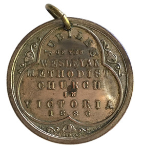
Badge - Jubilee of the Wesleyan Methodist Church Medal, 1886
In 1886 the Wesleyan Methodist Church celebrated the fiftieth jubilee of the establishment of the Wesleyan Methodist Association in Britain. The Association was one of several off-shoots of the Methodist Church, which had been established by John Wesley from the 1730s. Methodism stressed evangelism and a closer association with God. The focus on fiftieth anniversaries by the church originated in Leviticus 25:10: ‘And ye shall hallow the fiftieth year, and proclaim liberty throughout all the land unto all the inhabitants thereof: it shall be a jubilee unto you...’. In 1902 the various off-shoots of Methodism in Australia united to form the Methodist Church of Australasia. In 1977 the church became part of the Uniting Church. The Wesleyan Methodist Church which exists in Australia today is actually a branch of the Wesleyan Methodist Church of America, introduced to Australia during World War II. In 2003 it had almost 100 churches in Australia.Many of the early pioneers in the City of Moorabbin were Methodists.Silver Medal Side one: legend within trefoil; JUBILEE / OF THE / WESLEYAN / METHODIST / CHURCH / IN / VICTORIA / 1886 small floral decorations at each point of trefoil. Side two: Bust of John Wesleycity of moorabbin, wesleyan methodist church, religion, jubilee -
 City of Greater Bendigo - Civic Collection
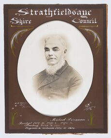
Photograph - Portrait of Councillor Brennan, W H Robinson
The district of Strathfieldsaye was proclaimed in 1861 and named a Shire on the 17th September in 1866. It remained a shire until amalgamation in 1994 when it became part of the City of Greater Bendigo. The shire was located 8 km to the south- east of Bendigo and covered an area of 601 square kilometres and extended from the Calder Highway to the Coliban and Campaspe Rivers. The shire's administration centre was in Strathfieldsaye until 1972 when new offices were opened in Kennington. Councillor Michael Brennan held roles of Shire Secretary and Clark of Works until around 1998 when his son R. B. Brennan was appointed Assistant Secretary and then Shire Secretary to assist his father with the work load during his later years. Michael Brennan remained Clerk of Works until his death at which time his son was appointed to the duties previously held by his father. Framed black and white head and shoulder portrait of Councillor Brennan with hand coloured and drawn detail. Profile to left. Cut oval brown mount decorated with text and flowers. Hand written title top and lower centreStrathfieldsaye / Shire Council / W H Robinson / Photo / Bendigo / J H B Gribble / Michael Brennan / President 1869 - 70. 1871 - 2. 1872 - 3 / Secretary 1882 to 1900 / Engineer & Valuator 1882 to 1902strathfieldsaye shire council, councillor brennan, president of strathfieldsaye shire -
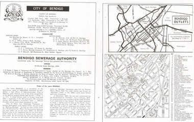 Bendigo Historical Society Inc.
Document - LONG GULLY HISTORY GROUP COLLECTION: CITY OF BENDIGO
Page with the titled City of Bendigo includes when the County was created, proclaimed a Borough, then a City and a name change, the area, population, swellings and Mayoral Allowance. Darling Ward Councillors were: Cr R L Campbell, The Mayor, Cr N C Jeffrey, and Cr J Pearce. Sutton Ward Councillors, Cr M Petersen, Cr R F Turner, and Cr C Stoltz. and Barkly Ward Councillors, Cr P T Tomkinson, Cr C Davies and Cr P Mansell. Bendigo Sewerage Authority Members: T R Flood, C Stoltz, P Tomkinson, R Campbell, R F Turner, A L Roy, K Houlahan, E Knight, J Bowles, M Brennan, H A Moors and V F Moyle. Also mentioned is the Origin of the name Bendigo. There is a small map of Bendigo Outlet roads and another map with services, attractions, churches, etc.bendigo, history, long gully history group, the long gully history group - city of bendigo, cr r l campbell, cr n c jeffrey, cr j pearce, cr m petersen, cr r f turner, cr c stoltz, cr p t tomkinson, cr c davies, bendigo disposals, cr p mansell, bendigo sewerage authority, t r flood, bendigo city council, a l roy, borough of eaglehawk, k houlahan, shire of strathfieldsaye, e knight, shire of marong, j bowles, shire of huntly, m brennan, h a moors, v f moyle, abednego, john wesley, abednego thompson, battling bendigo, richard sherratt, thomas myers, castleton, sandhurst, military college of sandhurst england -
 Ballarat Tramway Museum
Poster - Glass, Poster, Ballaarat Tramway Co. Ltd, 1889
Sheet of glass, cut to a shape, with the Ballaarat Tramway Co. By-laws - original copy, adhered to the one surface of the glass. See also item 783 or details of the By-Laws. proclaimed by the City of Ballaarat April 6?1889 and gazetted April 5 1889. Has 25 different by-laws. See item No. 1 for details of horse tram. Sheet of glass with the by-laws was found in one corner of the horse tram No. 1 when recovered. Sheet of glass was cracked in two locations and the paper of the by-laws has adhered to the glass. There is also a section of glass missing in the top right hand corner of the glass. When salvaged, placed onto a sheet of cardboard and lengths of sticky tape run across the glass and the cracks in the glass to keep it on the cardboard. Since removed from the cardboard and placed on sheets of acid - free board. Handle with care. Not to been used in an exhibition until full conservation treatment carried out.trams, tramways, law and order, by laws, horse trams -
 Kew Historical Society Inc
Plan, J R Mathers & McMillan, 5 Splendid vVlla Allotments,: Segtoune St. & Windsor St., Kew, 1928
Prue Sanderson, in her groundbreaking ‘City of Kew Urban Conservation Study : Volume 2 - Development History’ (1988), summarised the periods of urban development and subdivisions of land in Kew. The periods that she identified included 1845-1880, 1880-1893, 1893-1921, 1921-1933, 1933-1943, and Post-War Development. These periods were selected as they represented periods of rapid growth or decline in urban development. An obvious starting point for Sanderson’s groupings involved population growth and the associated economic cycles. These cycles also highlighted urban expansion onto land that was predominantly rural, although in other cases it represented the decline and breakup of large estates. A number of the plans in the Kew Historical Society’s collection can also be found in other collections, such as those of the State Library of Victoria and the Boroondara Library Service. A number are however unique to the collection.Subdivision plans are historically important documents used as evidence of the growth of suburbs in Australia. They frequently provide information about when the land was sold on which a built structure was subsequently constructed as well as evidence relating to surveyors and real estate and financial agents. The numerous subdivision plans in the Kew Historical Society's collection represent working documents, ranging from the initial sketches made in planning a subdivision to printed plans on which auctioneers or agents listed the prices for which individual lots were sold. In a number of cases, the reverse of a subdivision plan in the collection includes a photograph of a house that was also for sale by the agent. These photographs provide significant heritage information relating house design and decoration, fencing and household gardens.In 1928, five residential allotments bordering Segtoune and Windsor Streets were advertised for sale as part of a subdivision. Four of the blocks faced Segtoune Avenue. The auctioneers proclaimed the advantages of the sites: ‘Situate one minute from the High Street Electric Tram, which now runs direct to Spencer Street via Bridge Road and Flinders Street. Opposite the East Kew Railway Station (Outer Circle Line), which may be reopened In connection with the new Line from Kew to Doncaster; Adjacent lo the Kew Recreation Reserve, Sports Oval, and Swimming Bath; Half Minute from the Shopping Centre of East Kew, Accessible to the State School and Other Educational Centres’. The Harp of Erin Hotel and the route of the Outer Circle Railway line are marked on the plan. The Recreation Reserve and Sport Oval refer to Victoria Park. The Swimming Baths were located on the site of the current Kew Recreation Centre.subdivision plans - kew, segtoune street -- kew (vic.), windsor street -- kew (vic.) -
 Orbost & District Historical Society
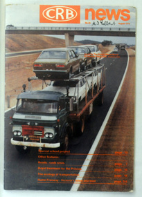
magazine, CRB News, August 1976
By 1910 it had become apparent that there was a need for a central roads authority to take over responsibility from the Board of Lands and Works for the care and management of the main roads of the state of Victoria. Because there was no consistent and systematic policy for road maintenance Victorian roads were in a deplorable condition. At this time the use of the motor car accentuated the demands for better roads. As a result of these needs the Country Roads Act 1912 was proclaimed in 1913 providing for the establishment of the Country Roads Board as a central road authority with responsibility for those roads within the State considered to be main roads. the C.R.B. was responsible for the construction of roads and bridges including the Snowy River road bridges in Orbost. This was a major project involving not only a new bridge over the Snowy River (including Lochiel Lagoon), but other bridges over Ashby’s Gulch and Watt’s Gulch. These new bridges were opened in November 1976 with the unveiling of a plaque on the eastern end of the $2.4M Snowy River Bridge. (ref. May Leatch) This is a useful reference tool on the history of the construction of the Snowy River road bridges.A journal, titled "CRB News" . On the front cover the title is in orange print with No. 33 August 1976 above a coloured photo of a truck carrying two tiers of new vehicles along a main sealed road. It contains information and photos of the construction of the Snowy River road bridges.on front cover - handwritten in black - "M. I. Gilbert"crb-news country-roads-board snowy-river-road-bridges -
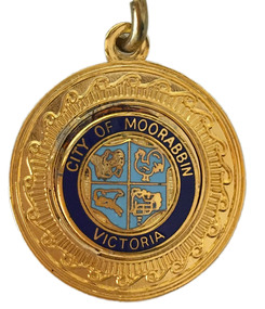 City of Moorabbin Historical Society (Operating the Box Cottage Museum)
Badge - City of Moorabbin Key Chain
“City of Moorabbin” The township of Moorabbin, known as South Brighton until 1909, remained small, with the Plough and Harrow Hotel as its main building. In 1917 Sandringham borough was formed by severance from Moorabbin shire and in 1920 Mentone and Mordialloc were also severed. In the remaining Moorabbin shire the Moorabbin township was still small (1,770 persons), but the shire grew in population during the 1930s. On 10 October 1934 it was proclaimed a city. It existed as a separate municipality until 1995. When local government boundaries were changed in 1994 about half of Moorabbin city was united with Glen Eira city and about half with Kingston city. On 15 December, 1994 the City of Chelsea, parts of the Cities of Mordialloc, Moorabbin, Springvale and Oakleigh were amalgamated to create the City of Kingston by Order of the Governor in Council. On the same day Glen Eira City Council was formed from the City of Caulfield and the remaining part of the City of Moorabbin.Gold Key ring with a dark blue circle surrounding the shield of the City of Moorabbin.City of Moorabbin, Victoria,city of moorabbin -
 City of Moorabbin Historical Society (Operating the Box Cottage Museum)
Programme - Two Programs for Mayoral Functions held in the City of Moorabbin. 1946 & 1953, City of Moorabbin Council, 1946 & 1953
“City of Moorabbin” The township of Moorabbin, known as South Brighton until 1909, remained small, with the Plough and Harrow Hotel as its main building. In 1917 Sandringham borough was formed by severance from Moorabbin shire and in 1920 Mentone and Mordialloc were also severed. In the remaining Moorabbin shire the Moorabbin township was still small (1,770 persons), but the shire grew in population during the 1930s. On 10 October 1934 it was proclaimed a city. It existed as a separate municipality until 1995. When local government boundaries were changed in 1994 about half of Moorabbin city was united with Glen Eira city and about half with Kingston city. On 15 December, 1994 the City of Chelsea, parts of the Cities of Mordialloc, Moorabbin, Springvale and Oakleigh were amalgamated to create the City of Kingston by Order of the Governor in Council. On the same day Glen Eira City Council was formed from the City of Caulfield and the remaining part of the City of Moorabbin.Official functions held in the City of Moorabbin 1946 & 1953Two program cards, one green 1946 and the other cream 1953. The inside lists the entertainment during the reception of the Mayoral functions of the City of Moorabbina) RECEPTION /given by the / MAYOR AND MAYORESS / of MOORABBIN / 1946 b) RECEPTION / given by the / MAYORESS of MOORABBIN / 1953mcc, marriott, ward, coates, city of moorabbin, reception, program cards, entertainment, market gardeners, early settlers, cheltenham, moorabbin, bentleigh -
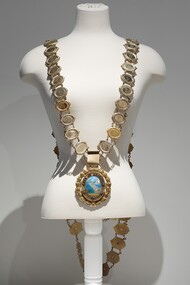 Bayside Gallery - Bayside City Council Art & Heritage Collection
Ceremonial object - Mayoral chain, Lega, City of Brighton Mayoral Chain, 1953
This chain was part of the official regalia worn by the Mayor of the City of Brighton before the amalgamation into Bayside City Council in 1994. The chain was seen as an outward sign of power, authority, and responsibility and was a formal, full-dress type of regalia that was worn by the mayor over their robes at ceremonial functions. The large central drop medallion featured the design of the council seal and the links of the chains detail the name and date of each appointed Mayor. This council seal features the Brighton coastline with a pier extending to the water, a sail boat in the distance and a train on the right of the pier. It was displayed by Council on its flag and letterhead and in municipal buildings and can still be seen on the portico of Brighton Town Hall. The seal was used from 1919, when Brighton was declared a city, until 1970, when an official crest was issued by the British College of Heraldry. Brighton was first incorporated as a borough on 18 January 1859, it became a town on 18 March 1887 and was proclaimed a city on 12 March 1919.9 carat yellow gold and enamel mayoral chain for the City of Brighton. Consists of 61 small oval links, with a scroll listing significant dates in Brighton's history as a centrepiece and a large 'drop' medallion of the City of Brighton seal below. Each oval link has a central plaque inscribed with a mayor's name and dates of their office surrounded by a thin coiled edge and a thick decorative border. The earliest Mayor is W.P. Francis 1918-19 and the latest is K.D. Oliver 1994-95. The links are joined by cable chain and form a long circular chain with two crosspieces of additional links at the back, the upper crosspiece contains four links, while the lower piece contains three links. The chain has a large oval medallion/pendant of the City of Brighton seal which is surrounded by a thin coiled gold edge, a border containing raised lettering 'CITY OF BRIGHTON' above and a Coat of Arms below. This is also surrounded by a coiled edge. The oval piece is then wrapped around with a thick laurel wreath with small berries. The central part of the medallion contains a coloured enamel image of the Brighton coastline with sand in the foreground, a pier extending out into the water, a sailboat in the distance and a train on the right of the pier. The small Royal Coat of Arms of the United Kingdom below includes a coloured enamel shield flanked by a lion and unicorn with a motto inscribed on a ribbon underneath 'DIEU ET MON DROIT'.mayoral chain, city of brighton, lega, ceremonial wear, seal, medallion, mayor, coat of arms, crest, bayside, mayoral regalia -
 Bayside Gallery - Bayside City Council Art & Heritage Collection
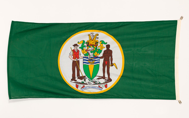
Flag, Evan Evans, City of Brighton flag
The coat of arms on this flag were granted by the British College of Arms in 1970 and represented Brighton City Council's "growing awareness of the importance of formality and correct symbolism in local government". It replaced the council's crest of a pier and yachting scene and was used as council's seal, emblem on its flag and letterhead. The new Coat of Arms, drawn up by the College of Arms in England, depicts the progression from a seaside gardening community to a modern residential city. The prominent forms are on the shield-like coat of arms include waves and a Lymphad (a ship, symbolic of the sea); a market gardener; an aboriginal man; two horns of plenty with abundant fruit and vegetables (the wealth and plenty) and Elster Creek (now Elster Canal). It is underscored by the motto "By their fruits, ye shall know them". Brighton was first incorporated as a borough on 18 January 1859, it became a town on 18 March 1887 and was proclaimed a city on 12 March 1919.Green flag with circular City of Brighton Coat of Arms in the centre. The central circle is white with a yellow edge, with a polychrome coat of arms featuring: the crest which is two cornucopia with fruits and vegetables, above sits a seagull. The mantle above the helmet is in green and gold. The shield is also green and gold with a lymphad (ship) and blue and white waves. The market gardener, holding a hoe, and Aboriginal figure, bearing a boomerang, support the shield and stand upon the compartment which is soil with a representation of Elster creek. A ribbon below contains the motto in blue 'FRUCTU NOSCITUR'.flag, brighton, city of brighton, coat of arms, college of arms, market gardener, aboriginal, elster creek, lymphad, fructu noscitur, armorial bearings, heraldry, cornucopia, by their fruits ye shall know them, motto -
 Wodonga & District Historical Society Inc
Functional object - Seal - Police Office, Belvoir
This seal was used for official police and court documents by the Belvoir Police Office.The initial land survey for the city now known as Wodonga was first undertaken in 1852 by Thomas Wedge - Assistant Surveyor. The new township was called "Belvoir" and was proclaimed by that name in 1852 and again in 1861. The first sale of land in Belvoir was held at Wangaratta on April 28, 1854, when all the allotments surveyed by Thomas Wedge (excepting those set apart for reserves, government and public areas) were offered at auction. Following representations by the Postmaster General on June 23, 1869, the Governor in Council, on July 12, 1869, approved of its Aboriginal name "Wodonga" being restored. The seal was found at the Yackandandah Courthouse by the Circuit Judge, the late Mr. Jim Humphrey. As the Wodonga Historical Society was in recess at that time, the seal was held in trust by the North-East Historical Society in Wangaratta. It was donated to the Wodonga Historical Society in 1987.This item was the official seal of the Belvoir Police office from the beginning of the European settlement of the modern day city of Wodonga, then know as Belvoir. It is one of the earliest relics of that period of history, until its name was changed in 1869.Wood and metal seal bearing the official emblem of the Police Office Belvoir. It would have been used to apply a wax seal to official documents. The seal is mounted in a timber and glass case so that the imprint of the seal can be seen reflected in a mirror mounted in the base of the box.Around the edges of the seal "POLICE OFFICE / BELVOIR"belvoir police, official seal, history wodonga -
 Wodonga & District Historical Society Inc
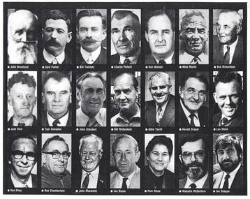
Photograph - Civic Leaders Wodonga 1876 - 1994
Wodonga Shire was created in 1876 when the colonial government agreed to ratepayers' petitions to have their part of the local government district severed from the Yackandandah Shire to form a new municipality. In March 1973 Wodonga was declared as the first Rural City in Australia. This was officially proclaimed by the Governor of Victoria, Sir Rohan Delacombe at an open-air ceremony in Hovell Street following a procession along High Street led by the Victorian Police Band. The first meeting of the held in the open air immediately after the proclamation. In 1994, the Jeff Kennett government restructured local government in Victoria. His reforms dissolved 210 councils and sacked 1600 elected councillors. Commissioners were appointed in their place. Wodonga’s Commissioners were Mel Reid, Des Kelly and Michael Hanson. Reforms introduced created 78 new councils through amalgamations. Democratically elected councillors returned to Wodonga in 1997, with Graham Crapp as Mayor.This item documents the leaders of local government in Wodonga since its inception in 1876 until Local Government reform in 1994.A photo collage representing Shire Presidents and Mayors of Wodonga, including a typed list of names and dates. All Shire Presidents and Mayors of Wodonga from 1876 – 1994 J. Woodland 1876-7, J. Bambrick 1877-78, G. Street 1878-79, W. L. Ferrier 1879-80, T. Reidy 1880-81, J. Bambrick 1881-82, A. Schlink 1882-83, T. Reidy 1883-84, N. P. Newnan 1884-86, J. Bambrick 1886-87, H. Harkin 1887-88, T. Johnston 1888-89, W.C. McFarlane 1889-91, P. Adams 1891-92, J. G. Shields 1892-93, H. Harkin 1893-94, W.C. McFarlane 1894-95, N. P. Newnan 1895-96, J. Bassett 1896-97, R. Morrison 1897-98, G. S. Manns 1898-99, H. Smith 1899-1900, H. Beardmore 1900-1901, G. Leighton 1901-02, J. H. McGeoch 1902-03, H. Beardmore 1903-1904, J. Whan 1904-05, A.E. Müller 1905-06, A. L. Wright 1906-07, J. H. McGeoch 1907-08, H. Beardmore 1908-1910, G. Leighton 1910-11, H. Beardmore 1911-1912, J. H. McGeoch 1912-13, G. Leighton 1913-14, H. Beardmore 1914-1917, S. T. Parker 1917-19, W. Twomey 1919-21, T. Ryan 1921-23, W. Twomey 1923-25, T. Ryan 1925-26, C. F. Pollard 1926-27, W. Twomey 1927-28, C. S. Street 1928-29, K. D. Watson 1929-30, M. Martin 1930-31, R, Richardson 1933-36, T. Ryan 1936-38, M. Martin 1938-39, R, Richardson 1939-41, J. S. Hore 1941-43, K. D. Watson 1943-45, C. F. Pollard 1945-47, C.C. Sheather 1947-48, T. E. Snowdon 1948-49, J. S. Hore 1949-50, G.A.W. Boyes 1950-52, D. J. Schubert 1952-54, V. R. Peard 1954-55, M. E. Morrison 1955-56, M. E. Morrison 1956-57, J. S. Hore 1957-60, D.J. Schubert 1960-61, A.B.S. Collins 1961-62, A. G. Richardson 1962-63, J. S. Hore 1963-65, J. A. Terrill 1965-67, H. W Draper 1967-68, J.A. Terrill 1968-71, *L.E. Stone 1971-74, K.T. Riley 1974-76, H. Draper 1976-77, Rex. Chamberlain 1977-80, H. W. Draper 1980-82, R. J. Macaulay 1982-84, L.O. Boyes 1984-85, **Pamela Stone 1985-86, M. McEachern 1986-87, R.J Macaulay 1987-88, I. Deegan 1988-89, Valentina Gillard 1989-90, R. J. Macaulay 1990-91, L. C. Boyes 1991-92, T. Corcoran 1992-94 *Last Shire President & first Mayor of the City ** First woman Mayor, Widow of L.B. Stonewodonga council, wodonga shire council, civic leaders -
 Warrnambool and District Historical Society Inc.
Original Document, Map: Agricultural area of Ballangeich 1865, 1865
George Eddington arrived in Australia in 1839 and named and established property in 1841 calling the property Ballangeich after a Pass near his home town of Stirling in Scotland. It is situated 151 miles west of Melbourne and to the south of Mortlake and was originally part of the Mortlake shire, which was proclaimed 26th Jan 1864. Nearest streams are the Hopkins Riverand Lyall and Drysdale creek running through good agricultural land. This map relates to the breaking up of large runs which the Victorian government enabled through selection acts of the 1860's. The previously larger runs which were mainly cattle and sheep based were now more open to closer settlement and a greater variety in farming.The lots range in size from approximately 50 acres to around 600 acres.Some areas are set aside for reserves. By 1886 the population of Ballangeich had grown to around 600 with an hotel, three state schools and a church.Tri weekly coaches ran to Colac, Warrnambool and Camperdown providing access to supplies mail and communication. This map is typical of many which were produced in the 1860's in Victoria during a significant period of Victoria's and Warrnambool district history.Rectangular light card paper with black text showing allotments of land The area is coloured in green with scale at bottom right cornerAt the top: Plan of the Agricultural area of Ballangeich 1865 At the bottom left: Prepared by the Board of Lands & Works in accordance with the Amending Land Act 1865 Lands & Survey Office Melbourne 13th April 1865. With signaturehistory of warrnambool, ballangeich, land surveys victoria 1865, lands act 1865 victoria, ballangeich map 1865 -
 City of Ballarat
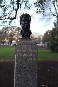
Artwork, other - Public Artwork, Wallace Anderson, Edmund Barton (Prime Ministers' Walk) by Wallace Anderson, c1940
Edmund 'Toby' Barton, Australian politician and judge, served as the first Prime Minister of Australia after the Commonwealth of Australia was proclaimed on 1 January 1901, in office from 1901 to 1903. The Prime Ministers Avenue is a collection of bronze bust portraits of the Prime Ministers of Australia, located at the Ballarat Botanical Gardens in Ballarat, Victoria. The Prime Ministers' portraits are commissioned after the incumbent term of each Prime Minister by the City of Ballarat. The City of Ballarat has taken responsibility for commissioning the busts after funds set aside by politician Richard Armstrong Crouch were exhausted in 2014. Crouch originally donate money to pay for six busts, the first of which was unveiled in 1940. The collection of prime ministers' busts are unique in Australia, representing the only sculptural portrait collection of all past Australian Prime Ministers. The different styles used reflect the unique artistic practices of the selected artists; textures, sizes and features and proportions are used by the artists to interpret the characteristics of each of the subjects.The artwork is of historic and aesthetic significance to the people of BallaratBronze bust cast on granite plinth Edmund Barton Prime Minister 1901-03 first prime minister, australian prime minister -
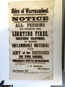 Warrnambool and District Historical Society Inc.
Document, Shire of Warrnambool Fire - Washing-Bridge 1882, 1882
This notice relates to the prohibition of lighting fires,drying clothes or bringing inflamable material near any of the bridges in the shire. Offenders will be prosecuted. With a date of 1882 and the fact that bridges were mostly made of wood, it would have been of concern that the destruction of bridges was not only of great inconvenience but also of considerable expense. But the reality of bridges providing shelter and warmth in the colder months and the ensuring fires and burnt bridges has more than likely precipitated this notice. J W Crawley was shire engineer from 1876 until 1895 and for 10 of those years he trained his son J W Crawley who succeeded his father and served in the position for 40 years.He in turn was succeeded by his son Rolf Crawley in 1935. In 1963 the bridge over the Hopkins Falls at Wangoom was named the Crawley bridge in honour of service to the Shire of Warrnambool by members of the Crawley family. The Shire of Warrnambool was proclaimed in 1863 and covered an area of over 600 square miles. Much of it was incorporated into the Moyne Shire in the 1990's with some being included into the boundaries of City of Warrnambool. This banner is an interesting piece of history. It shows the issues confronting early settlers such as shelter and the chores of daily life but also the importance placed on infrastructure which was slowly taking place around the district. It was in the era of drainage and roadworks and hence bridges were an important part of that infrastructure. The name J W Crawley is one of importance in the Warrnambool district for his service over many years. Rectangular piece of cloth printed in black ink. The back is plain.Shire of Warrnambool By order of J W Crawley Shire Engineer, 13th November 1882. Thos Smith gas Printing Works Koroit Street Warrnambool.warrnambool, shire of warrnambool, bridges of warrnambool shire, j w crawley, warrnambool shire engineer, crawleys of warrnambool -
 Orbost & District Historical Society
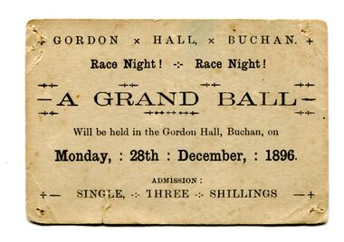
Document - ticket, 1896
Gordon Hall was the first public building in Buchan. European settlement first entered the area in October 1838 and Buchan station was established in January 1839. Free selection after 1868, and a township was proclaimed in 1873 taking its name from the station. The Grand ball was held on race night, Monday 28th December 1896 in the Gordon Hall at Buchan. From the estate of Elsie Cooke. Elsie Cooke was a librarian in Orbost for many years. She was the daughter of John Cooke early Brodribb settler. Elsie Cooke lived all her life in Gippsland,. She was born at Brodribb in 1895 and died in 1970, Elsie Cooke lived at Bruthen for a short time and, in 1937, moved to live with her aunt, Miss Jean Munro. Miss Cooke was Librarian at the Mechanics Institute for many years. Kindness and consideration for other were Miss Cooke’s attributes and she endeared herself to all who knew her. She was a loyal member of the Presbyterian Church and a stalwart of the Ladies’ Guild, an energetic worker for the Municipal Auxiliary and a member of the Red Cross. (ref. Mary Gilbert)This item reflects the recreational / social activities of a remote rural community. A public event such as a grand ball would have been a significant event on the calendar.Small, cream-coloured rectangular card with rounded edges and blank ink. Evidence of pin holes in each four corners and folds/signs of wear. Card is foxing and has small vertical tear in lower left quadrant.+ GORDON x HALL, x BUCHAN. + / Race Night! - Race Night! / A GRAND BALL / Will be held in the Gordon Hall, Buchan, on / Monday, : 28th : December, : 1896. / ADMISSION : / +- SINGLE, THREE SHILLINGS -+grand ball, 1896, gordon hall, buchan, elsie cooke -
 Bendigo Historical Society Inc.
Book - JOAN O'SHEA COLLECTION: 150TH ANNIVERSARY OF BENDIGO BOOKLET, 1850 - 1950's
Joan O'Shea Collection. Buff Coloured Booklet City of Bendigo. 150th anniversary of Bendigo 1850s to 1950s. Image on cover coat of arms for City of Bendigo underneath word progress, left hand side horse, right hand side bullock. History of Bendigo: From Sheep Run to Provincial City in 100 years. Map of Bendigo and Surrounds Railways, Water Courses & Storage, Power, Municipal Boundaries & Land Available for Industry. Municipal District Creation 1855, Borough Proclamation 1863, Proclaimed City 1871, Area: 7992 Acres Population as of last census City of Bendigo 28,722, City of Bendigo and adjacent Urban Areas 36,909. City of Bendigo Map, The Past Prior to 1850. Icons of Bendigo The Bendigo base Hospital,Law Courts & Post Office, Primary Schools, Housing, Industry including Butter Production, Poultry Farming, Livestock Sales & Tomato Growing, Slaughter House & ordnance factory. The Present Recreation Photos: Bendigo Bowling Club, Queen Elizabeth Oval, Municipal Lawn Tennis Courts The Future of Bendigo, Bendigo Photographs From The 1950s,Cambridge Press Bendigobendigo, history, progress of bendigo 1850s on. -
Bendigo Historical Society Inc.
Document - Scout and Guide Coronation Service, 1953
The coronation of Elizabeth II as queen of the United Kingdom and the other Commonwealth realms took place on 2 June 1953 at Westminster Abbey in London. She acceded to the throne at the age of 25 upon the death of her father, George VI, on 6 February 1952, being proclaimed queen by her privy and executive councils shortly afterwards. The coronation was held more than one year later because of the tradition of allowing an appropriate length of time to pass after a monarch dies. It also gave the planning committees adequate time to make preparations for the ceremony. During the service, Elizabeth took an oath, was anointed with holy oil, was invested with robes and regalia, and was crowned Queen of the United Kingdom, Canada, Australia, New Zealand, South Africa, Pakistan, and Ceylon (now Sri Lanka). Celebrations took place across the Commonwealth realms and a commemorative medal was issued. It was the first British coronation to be fully televised; television cameras were not allowed inside the abbey during her parents' coronation in 1937. Elizabeth's was the fourth and final British coronation of the 20th century. It was estimated to have cost £1.57 million (c. £53,571,428 in 2023).Scout and Guide Coronation Service of Thanksgiving. In the presence of His Excellency the Governor, State Chief Scout and Lady George, state president of the girl guides, Adelaide town Hall Sunday 21 June 1953 - four pages.history, bendigo, boy scouts, girl guides -
Port Melbourne Historical & Preservation Society
Film - Video Recording - Digital, I Wish I Had Been There, 28 Jul 2020
The Port Melbourne Historical and Preservation made history on the 28 July 2020 when, because of the COVID-19 pandemic, we hosted our first meeting via Zoom.Digital video recording of PMHPS meeting held via Zoom on 28 July 2020. Eight members spoke on the theme “I Wish I Had Been There …” Margaret BRIDE wishes she had there when Wilbraham LIARDET had ridden up and down Bay Street proclaiming the separation of Victoria from New South Wales. John MAY wishes he was there in 1937 when Port Melbourne and Williamstown Football Clubs swapped players. Sue LEONG wishes she was there in July, 1901 in front of the building where she now lives but previously was a stables and carrier’s business. David RADCLIFFE wishes he was there in March, 1924 when the HMS Hood and the HMS Repulse arrived in Port Melbourne. Beris CAMPBELL wishes she was there in 1974 at Arch TODD's Mayoral Ball at Port Melbourne Town Hall. Garry SMART wishes he was there for the Sandridge Council meeting held at the newly built court house on 23 August 1860. Helen BARRY wishes she was there at the Graham Street railway gates where her grandfather proposed to her grandmother. Lex JOHNSON wishes he was there on the last Saturday in August, 1946 when Port Melbourne took on Coburg at North Port Oval.margaret bride, wilbraham frederick evelyn liardet, wfe liardet, separation, john may, port melbourne football club, williamstown football club, sue leong, knight's transport, david radcliffe, hms hood, hms repulse, beris campbell, archibald (arch) todd, celebations - balls, gary smart, local government - municipal district of sandridge, court house, helen barry, lex johnston, coburg football club -
 Marysville & District Historical Society
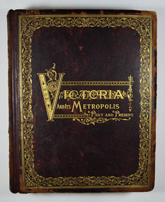
Book - Hardcover book, McCarron, Bird & Co, Victoria and its Metropolis-Past and Present-Volume 2, 1888
A history of the various colonies and districts of Victoria from the time of the discovery of Australia through until 1888.Hardback. Dark brown cover with the title in gold lettering. There is also a border in gold decorating the outer edge of the front cover. The spine is also decorated in gold along with the title and the volume number.non-fictionA history of the various colonies and districts of Victoria from the time of the discovery of Australia through until 1888.melbourne, victoria, pioneers, colonisation, history, fauna, flora, banking, finance, medicine, western district, south-western district, wimmera district, geelong district, ballarat district, avoca district, coliban district, campase district, loddon district, lower goulburn district, upper goulburn district, ovens district, north-east district, gippsland district, mornington district, westernport district, upper yarra district, evelyn district, bourke district -
Glen Eira Historical Society
Book - Local Government Act First Report of the Assistant Commissioner of Roads and Bridges
This file contains 1 item: 1/The Local Government Act, First Report of the Assistant Commissioner of Roads and Bridges, printed by order of the Victorian Legislative Assembly on 08/03/1865. The document is the first annual report of John Steavenson, Assistant Commissioner of Roads and Bridges under s330 of the Local Government Act no. 176 (1863), and relates to transactions which took place from 02/09/1863 to 31/12/1864. The report outlines operations carried out by the Department of Roads and Bridges in this period. In the Glen Eira area this includes: separating electoral subdivisions of single districts (Moorabbin), adding detached portions of territory to road districts and shires (Caulfield), appointing of and altering in polling places, appointing of polling places for ridings of shires and subdivisions of road districts (Moorabbin), preparing and transmitting of forms of books also of pro forma accounts for guidance of local bodies in keeping their accounts, appointment of main roads, construction of a main road, ‘Dandenong’, in the Caulfield and Gardiner districts, proclaiming of Common Toll Roads, names of and security given by Managers of Common Toll Roads. The report also gives some information about the Shire of Caulfield, which contained 24 road districts and 340 rate payers in 8¼ square miles, and the Shire of Moorabbin, which contained 62 road districts and 713 rate payers in 30 square miles.local government act, assistant commissioner of roads and bridges, legislative council, caulfield historical soceity, steavenson john, sullivan j. f. the honourable, caulfield, moorabbin, road districts, point nepean road, nepean highway, dandenong road, princes highway, brown edwin, osher joseph, cosgrove john, ferres john, roads and bridges offices, caulfield roads district, moorabbin roads district, road construction and maintenance, roads and streets, acts of parliament -
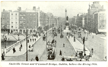 Federation University Historical Collection
Postcard - Postcards - black and white, Coleman & Co, Dublin before and after the Rising, 1916, c1916
The Easter Uprising took place in April 1916 in Dublin and is one of the pivotal events in modern Irish history. At the end of the Easter Uprising, 15 men identified as leaders were executed at Kilmainham Jail. To some, these men were traitors, to others they became heroes. (http://www.historylearningsite.co.uk/1916_easter_rising.htm, accessed 16 April 2014) Organised by seven members of the Military Council of the Irish Republican Brotherhood,[3] the Rising began on Easter Monday, 24 April 1916, and lasted for six days. Members of the Irish Volunteers — led by schoolmaster and Irish language activist Patrick Pearse, joined by the smaller Irish Citizen Army of James Connolly, along with 200 members of Cumann na mBan — seized key locations in Dublin and proclaimed the Irish Republic independent of the United Kingdom. There were some actions in other parts of Ireland: however, except for the attack on the Royal Irish Constabulary barracks at Ashbourne, County Meath, they were minor. With vastly superior numbers and the use of artillery, the British army quickly suppressed the Rising, and Pearse agreed to an unconditional surrender on Saturday 29 April. Most of the leaders were executed following courts-martial, but the Rising succeeded in bringing physical force republicanism back to the forefront of Irish politics. (http://en.wikipedia.org/wiki/Easter_Rising, accessed 16/04/2014) Sackville Street Dublin is now known a O'Connell Street.Seven black and white postcards showing photographic scenes before and after the Rising in Dublin.chatham family archive, chatham, holmes, ireland, dublin, uprising, sackville street, o'connell bridge, citizen army, liberty hall, henry street, nelson's pillar, post office, arnott's, abbey street, ruins, hotel metropole, the rising, easter uprising, easter rebellion, o'connell, chatham family archive, chatham, holmes, ireland, dublin, uprising, sackville street, o'connell bridge, citizen army, liberty hall, henry street, nelson's pillar, post office, arnott's, abbey street, ruins, hotel metropole, the rising, easter uprising, easter rebellion, o'connell -
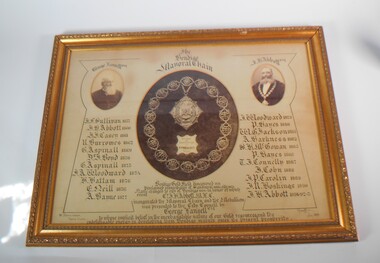 Bendigo Historical Society Inc.
Memorabilia - FRAMED IMAGE OF BENDIGO MAYORAL CHAIN
Large framed item. At the centre a photograph of the Bendigo Mayoral Chain designed and manufactured by F. Prescott, jeweller, Bendigo At the right a photo of George Lansell esq. and on the left a photo of J.H. Abbott esq. A list of Mayor is underneath the two photos, starting from the left J.F. Sullivan 1857, J.H. Abbott 1860, J.J. Casey 1861, R. Burrows 1862, G. Aspinall 1869, J. Boyd 1870, G. Aspinall 1873, J.A. Woodward 1874, H.Hattam 1876, E. Neil 1876, A. Bayne 1877, J.A. Woodward 1879, P. Hayes 1880, W.G. Jackson 1881, A. Harkness 1882, S.H. McGowan 1885, P. Hayes 1886, T.J. Connelly 1887, J. Cohn 1888, J.P. Carolin 1889, J,R. Hoskins 1890, J.H. Abbott 1891-92-95. Under the Mayoral chain the words: Bendigo gold fields discovered 1851. Proclaimed municipality of Sandhurst 1855 and city in 1871. Name changed to City of Bendigo in honor of which event cnr. J.H Abbott inaugurated the mayoral chain and the medallion was presented to the City Council by George Lansell esq. To whose implicit belief in the inextinguishable nature of our gold resource and the indefatigable energy in developing them Bendigo manly owes its present prosperity. July 1893, W. Honeybone Town Clerk and signed by F. Prescott.bendigo, council, mayoral chain, from dudley house stored at bendigo art gallery from 2000, returned to bhs 03/02/2023 -
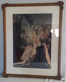 Flagstaff Hill Maritime Museum and Village
Print - Commemorative Portrait, H.M. Queen Elizabeth II, Ca. 1954
This commemorative framed print was a gift presented by Freemason, Worship Brother J. Wishart Junior, who also had the title of Worshipful Master of the Masonic Lodge from 1983-1954. This print was possibly presented by Wor. Bro. J. Wishart to the Masonic Lodge in Warrnambool the year following the coronation of Queen Elizabeth II, just after Wishart completed his term as the Worshipful Master of the Lodge. It is likely that the portrait was also part of the furnishings when one of Flagstaff Hill's village buildings was set up as a 19th century style Masonic Lodge, as shown in the map of the village in 1994 and was activated by a member of the Masonic Lodge. (Before this time the building was a Reference Library, and some time afterwards it was a Reading Library, and is now a Mechanics' Institute.) Australia is part of the British Commonwealth. Respect for the reigning monarchy of the colony of Australia has been shown here since colonisation and continued after Federation. Portraits of the reigning sovereignty have been displayed in public organisations, government departments and clubs over the years. Children in schools have been taught to 'Honour the flag, serve the Queen" (or King) etc. In February 1952 King George VI of England passed away. His daughter was proclaimed Queen, and crowned as H.M. Queen Elizabeth II on June 2nd, 1953, at Westminster Abbey, London. It is interesting to note that on 12th April, 1997, Warrnambool's Masonic Centre in Kepler Street held a 150 years celebration of the settlement of Warrnambool and District. A time capsule was inserted in the 'foundation stone' and one of the items inside it was a Flagstaff Hill Heritage Centre leaflet. The portrait of the coronation of H.M. Queen Elizabeth II and her continued reign of 70 years is significant, as it marks a very special occasion in the history of Britain and its Commonwealth. This portrait is similar to many other portraits of the Queen's coronation and is familiar to Australian citizens of the current generation and the ongoing link to Britain's colonasit6ion of Australia.Print, coloured, framed behind glass. Portrait of H.M. Queen Elizabeth II at her Coronation on June 2nd, 1953. The Queen is seated and wearing a white gown and white-trimmed blue cape. She is wearing a jewelled crown and holds the ceremonial Orb and Sceptre. In the background is Westminster Abbey. The decorative frame is cast composite or plaster. A card provided with the print advises that the print was presented by J. Wishart - it is attached to the reverse.Handwritten in ink on card "H.M.QUEEN ELIZABETH II / PRESENTED BY / WOR. BRO. J. WISHART JNR. / WOR. MASTER 1953-1954."flagstaff hill, warrnambool, maritime village, maritime museum, flagstaff hill maritime museum & village, shipwreck coast, great ocean road, 2-06-1953, westminster abbey, scepter, orb, royal crown, coronation, queen elizabeth ii, hm queen elizabeth ii, royal portrait, h.m. queen elizabeth ii, worshipful brother, worshipful master, time capsule, 19th century style masonic lodge, warrnambool 150 years celebration, coronation of queen elizabeth ii, freemasons, j. wishart, flagstaff hill masonic lodge building, portrait -
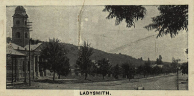 Federation University Historical Collection
Photograph (black & White), Ladysmith - South Africa
Ladysmith is a city in the Uthukela District of KwaZulu-Natal, South Africa. In 1847 after buying the land from the Zulu King Mpande, a number of Boers settled in the area and called it the Republic of Klip River. The Republic was annexed by the British in the same year and on 20 June 1850 it was proclaimed a township called Windsor. In October 1850 the name changed to Ladysmith after Juana Maria de los Delores de Leon Smith, also known was "Lady Smith", the Spanish wife of Sir Harry Smith, the Governor of the Cape Colony. He was also High Commissioner in South Africa from 1847 to 1852. A for was built in 1860 to protect the villagers from the Zulu. During the Second Boer War British commander Lieutenant General Sir George White made Ladysmith his centre of operations for the protection of Natal against the Boer forces. A number of short lived battles were fought for the control of the town. After suffering many casualties the British retreated to Ladysmith. While the British regrouped in the town, Boer forces surrounded Ladysmith. The siege lasted 118 days during one of the most crucial stage of the war. Three attempts by General Sir Redvers Buller to break the siege resulted in defeat for the British forces at the Battles of Colenso, Spion Kop and Vaal Krantz. The Boer forces attempted to break the siege. This led to the Battle of Platrand, or Wagon Hill, south the town. Buller finally broke the siege in February 1900 after defeating the Boers. Sir Winston Churchill, a young war correspondent was present at the Relief of Ladysmith after having been taken prisoner - between Ladysmith and Colenso - and escaping earlier during the war.Individual image from photographed poster of tobacco and cigarette cards.ladysmith, south africa, zulu, boers, republic of klip river, windsor, lady smith, sir harry smith, governor, cape colony, high commissioner, sir george white, natal, siege of ladysmith, sir redvers buller, battle of colenso, battle of platrand, sir winston churchill, wagon hill -
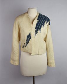 National Wool Museum
Clothing - Jacket, Mrs Jean Inglis, 1988
This jacket is by the prolific spinner and weaver Jean Inglis. It has been woven with a warp of commercially brought wool & a weft of hand spun Corriedale. It is completed in a Swedish lace style of weaving. The highlight of the jacket is the blue section of fabric on the top left shoulder of the wearer, which works down to the bottom right hip. This pattern looks like long thin individual separate sections of fabric stitched to the jacket; however, only one section of fabric has been added. A dying technique has been utilised to give the appearance of multiple sections. This Japanese dyeing technique is called Shibori, “to wring, squeeze or press". It is a manual tie-dyeing technique, which produces several different patterns on fabric. The specific pattern on this fabric is known as Kumo Shibori. It utilises bound resistance. This technique involves folding sections of the cloth very finely and evenly. Then the cloth is bound in very close sections. The result is a very specific spider-like design. This design requires very precise technique. Specific to this jacket, the fabric for the dyed section was made with the same fabric as the rest of the jacket. A section of the excess fabric was concertina wrapped around a 100mm pipe and tied up before dying. This gives the consistent straight blue lines, with no bleed from the dye. The sections were then sewed into the jacket with the occasional sequin added for additional decoration and glamour. The jacket won 1st prize at the 1988 Geelong Show. Jean was assisted by the dress maker Ruth Randell with some of the design and sewing. Jean always found sewing “a bit of a bore”. The jacket also has an attached swing tag. It was added to provide information to the judges at the Melbourne Show on how the jacket was created. It comes complete with Jean’s self-proclaimed terrible handwriting. It was donated to the National Wool Museum in 2021.Cream singled breasted jacket with no overlap. The jacket has no column of buttons for fastening, or lapels. It is designed to be plain, to not draw attention. The jacket is highlighted by the Shibori dyed waves on the top left shoulder of the wearer, which works down to the bottom right hip. This blue dyed section of fabric is dotted with the occasional blue sequin. Internally, the jacket features a white silk lining for comfort. The jacket ends in a straight cut hem, including at the cuffs. The jacket has an attached swing tag. The swing tag is cream with a printed thin black boarder. Within the boarder, handwriting in black ink is found. It has a hole punch in the top left corner of the swing tag for attaching to the jacket.hand spun, hand weaving, textile design, textile production, shibori, kumo shibori -
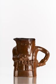 City of Greater Bendigo - Civic Collection
Artwork, other - Bendigo Pottery Toby Jug, Bendigo Pottery, Ned Kelly, c 1977
Established by George Guthrie in 1857 (about 5km north of its current site) and then again seven years later in 1864 after it initially closed, Bendigo Pottery remains one of the most influential and longest running Pottery’s in Australia. Over the years the Pottery has contributed to the growth and development of the district through both its products including building products, table ware and decorative and commemorative war as well as artistically, being responsible for training and supporting many potters locally. The City of Greater Bendigo has had a long history of partnering with Bendigo Pottery and the Civic Collection holds a number of important items within its collection. Ned Kelly is one of Australia's most iconic outlaws. Kelly was born and raised in rural Victoria, the third of eight children to Irish parents. His father, a transported convict, died in 1866, leaving Kelly, then aged 12, as the eldest male of the household. The Kelly's were a poor selector family who saw themselves as downtrodden by the squattocracy and as victims of persecution by the Victoria Police. While a teenager, Kelly was arrested for associating with bushranger Harry Power and served two prison terms for a variety of offences, the longest stretch being from 1871 to 1874. He later joined the "Greta Mob", a group of bush larrikins known for stock theft. A violent confrontation with a policeman occurred at the Kelly family's home in 1878, and Kelly was indicted for his attempted murder. Fleeing to the bush, Kelly vowed to avenge his mother, who was imprisoned for her role in the incident. After he, his brother Dan, and associates Joe Byrne and Steve Hart shot dead three policemen, the government of Victoria proclaimed them outlaws. Kelly died aged 25 at Melbourne Goal after being captured by Police in Glenrowan and sentenced to death. (Source Wikipedia).Brown glazed slip cast jug. Includes details which are iconic to the image of Ned Kelly including face and body armour pistol and gloves. Ned's left arm forms the handle.Verso; NED KELLY / Bendigo Pottery Epsom (stamp) Underside; Bendigo Pottery / Limited / Edition Series / 879 / 3000 / Australiacity of greater bendigo tourism, bendigo pottery -
Ringwood and District Historical Society
Badges, Badges and Coins 1939-45: 50 years of Queen Victoria's Reign; ANZAC Pins, King George and Queen Elizabeth; City of Wangaratta; etc, 1939 - 1945
Many issues - ANZAC DayBadges and coins. Refer photograph. +Additional Keywords: Pratt, G / GibbonTop Row L_R:; Victoria - 50 Years of Reign. Diam 3cm.; RDFA/Time Keeper (2 badges); Plastic 7-pointed badge (2 badges): Palestine-Gallipoli, FRANCE, Egypt, Mesopotamia, North Sea, New Guinea. In Centre: Lest We Forget printed across a map of Australia.; Assorted ANZAC pins/badges (5 badges); Middle Row L-R:; Side 1: King George VI & Queen Elizabeth (5 badges); Side 2: City of Wangaratta. Wangaratta Proclaimed a City.; Bottom Row:; Royal Life Saving Society, Established 1891. Centre: Awarded to G. Gibbon 1945.; Awarded to G Pratt v 1945; Victorian Rifle Association (2 badges); Legacy Badges/Pins (2 badges); Map of Australia on metal pin; Badge: Side 1 Centenary of Victoria 1934. On undeveloped scene embossed)/ Side 2 Centenary of Victoria 1935. (On city skyline embossed) Diam 2.6 cm.; Pavilion Fund Bayswater 1947-1948