Showing 1987 items
matching victoria bridge
-
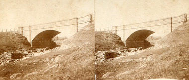 The Beechworth Burke Museum
Photograph - Stereoscopic Photograph, Unknown c1875
... Falls Bridge, in Beechworth, Victoria. Noted for its location... or the Newtown Falls Bridge, in Beechworth, Victoria. Noted for its ...Depicted in the photograph is Newtown Bridge or the Newtown Falls Bridge, in Beechworth, Victoria. Noted for its location, detailed craftsmanship and stonemasonry by Scottish stonemasons the Newtown Bridge was built in the 19th century provincial town of Beechworth (completed in 1875). The bridge was built over Spring Creek, spanning 6.3 meters wide and 24.8 meters tall. Beechworth held a distinct role in the administrative and commercial management of Victoria's north-eastern goldfields, with many objects and structures still well preserved from the towns establishment. The bridge indicates the growth of the town, replacing a previous timber structure as well as its association to the mining activity in the area and the rapid increase in Australia's economy that led to investment and development of roads and railways. The local granite used in the construction of the single arch Newtown Bridge makes the bridge and other buildings made with the granite unique to the area, the honey-toned material distinct to Beechworth. This photograph is historically significant as it provides insight into the industrial development of Beechworth and the surrounding area, contributed to by the goldfields. The photograph further captures the representation of vernacular engineering traditions and Scottish stonemasonry.Two sepia-toned rectangular photographs featuring a bridge in the background printed on matte photographic paper mounted on card.Reverse: 97.2324/ Newtown Bridge/ Beechworthbridge, newtown beechworth, newtown bridge, newtown, beechworth, beechworth falls bridge, beechworth mining district, spring creek, -
 The Beechworth Burke Museum
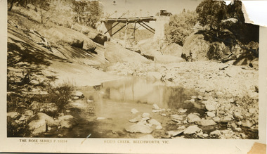
Postcard, Early 1900s
A postcard taken of Reid's Creek in Beechworth, taken in the early 1900s. This image is a representation of early automboile usage in the Beechworth area, with the car crossing the Reid's Creek bridge. Taken in Sepia tone it also has a detailed look of the foundations of the early bridge.Sepia rectangular photograph printed on matte photograph paperObverse The Rose Series P.10534 / Copyright Reid's Creek, Beechworth, Vic Reverse Left Side of Reverse: Published by the Rose Stereograph / Armadale, Victoria Top of Reverse: Post Card /Printed drawing of a rose The “Rose” Series / De Luxe A Real Photograph / Produced in Australia 1997.2607 Tanley Lower Right of Reverse: 2906 automobile, bridge, reid's creek, beechworth, postcard -
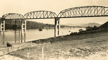 The Beechworth Burke Museum
Photograph
Taken between 1928 and 1930, depicted is the Bethanga Bridge under construction. The Bridge was completed in 1930 and was built to assist residents of the Bethanga district to travel to Albury. Other bridges would become submerged by the backed-up water of the Murray and Mitta Rivers so the Bethanga bridge was built two miles above the Mitta Weir. The Bethanga Bridge was built north of the future Hume Dam which would be completed in 1936. At 2430 feet long, Bethanga Bridge was the longest road bridge in Australia at the time of its completion. The Bridge is 20 feet wide and made up of nine 270 feet long spans. Materials used include ten tons of paint for the steel works; 1600 tons of steel; 900 tons of timber for the decking; and reinforced concrete for the piers. The tender for the construction was awarded to C. Ruwolt Pty. Ltd., engineers who were located on Victoria Street, West Richmond. The contract was awarded for £71,890. It was predicted between 250 and 300 men would find employment on the project. The news was well received by trade unions at the time as there had been a drop in available engineering work.This photograph is historically significant as it depicts the progress of the Bethanga Bridge construction, which was important infrastructure for the area. It is also a good example of methods used in the area to assist in travel over the river prior to the construction of the Hume Dam.Black and white rectangular photo printed on matte photographic paper.Reverse: 1997 3186 / 84-19-3 / This is the bridge. / It is not yet open to traffic / yet. will not be completed / until May next / It is a wonderful bridge the / pillars are 100 feet high. / KODAK PRINT Envelope Obverse: Peterson PHOTO / Hume Weir Envelope Reverse: BMM 84-20-1,2+3. bethanga bridge, lake hume, hume dam, hume weir, murray river, bridge, bethanga, albury -
 The Beechworth Burke Museum
Geological specimen - Feldspathic Sandstone
Feldspathic arenites are sandstones that contain less than 90% quartz, and more feldspar than unstable lithic fragments, and minor accessory minerals.Feldspathic sandstones are commonly immature or sub-mature.These sandstones occur in association with cratonic or stable shelf settings. Feldspathic sandstones are derived from granitic-type, primary crystalline, rocks. If the sandstone is dominantly plagioclase, then it is igneous in origin Sandstone features prominently in public buildings throughout Victoria. Most of the sandstone used as dimension stone in the State came from three sources: the Heatherlie quarry in the Grampians (Silurian), the Bacchus Marsh area (Permian), and the Barrabool Hills near Geelong (Cretaceous).Sandstone features prominently in public buildings throughout Victoria, making this specimen special as it shows the materials used by Victorian building companies. Sandstone can also be crushed, crushed stone is used in the construction of roadways and road structures such as bridges, and in buildings, both commercial and residential. This specimen is part of a larger collection of geological and mineral specimens collected from around Australia (and some parts of the world) and donated to the Burke Museum between 1868-1880. A large percentage of these specimens were collected in Victoria as part of the Geological Survey of Victoria that begun in 1852 (in response to the Gold Rush) to study and map the geology of Victoria. Collecting geological specimens was an important part of mapping and understanding the scientific makeup of the earth. Many of these specimens were sent to research and collecting organisations across Australia, including the Burke Museum, to educate and encourage further study. A feldspar-rich sandstone, a sandstone intermediate in composition between an arkosic sandstone and a quartz sandstone, containing 10% to 25% feldspar and less than 20% matrix material of clay, sericite, and chlorite. Feldspathic arenite containing less than 90 percent of the composition of quartz. Feldspar is the main composition. Feldspathic arenite may contain fragments of unstable rock, and a little amount of other minerals such as mica and heavy minerals. Some feldspathic arenite have pink or red color because of the presence of potassium feldspar or iron oxide. There are also colored light gray to white. These sandstones are usually medium to coarse grained and can contain a high percentage of granules with angular until subangular roundness. The content of the matrix can appear as the rest up to more than 15 percent, and sorting of grains can present as moderate to poorly sorted. Feldspathic sandstones are generally immature in textural maturity. Feldspathic arenite can not be judged from the structure of the sediment. Bedding can emerge from the laminate parallel to the crossbed. Fossils may appear in the layer deposited on the sea. Feldspathic arenites usually appear on the craton or the continental shelf, which can be associated with conglomerate, quartz lithic arenite, carbonate rock, or evaporites. This sandstone may also appear on the succession of sedimentary basins deposited on an unstable or deep sea, and moving arc setting. According to Pettijohn (1963) Arkose make up about 15 percent of all sandstones. Some Arkose formed in situ when the granite and related rocks disintegrate and generate granular sediments. Most of the material feldspathic sandstones derived from primary crystalline granitic rocks, such as granite or metasomatic rocks containing abundant potassium feldspar. Mineral contained in sandstones is mostly a form of plagioclase feldspar derived from quartz diorite or volcanic rock. Feldspar contained on this sandstone comes from arid to cool climates when the chemical weathering process is reduced.sandstone, natural stone, feldspathic sandstone, burke museum, geology, geological, geological specimen -
 The Beechworth Burke Museum
Photograph, Unknown c.1930s
This image shows Bethanga Bridge, which was constructed between 1927 and 1930 in Albury, NSW. The bridge was a necessity due to the building of the Hume Dam (Wier), 1919-1936. Bethanga Bridge is a long, nine-span, riveted-steel, variable depth, Pratt Truss road bridge of nine principal spans of 82 metres and a total length of 752 metres over the flooded valley of the Murray River, now part of Hume Reservoir. Because of its unique location, over the waters of a dam with the border running down the centre of the body of water, the Bethanga bridge is the only built structure shared by both New South Wales and Victoria. It was built 1.6 kilometres upstream of the dam and in 1961 was raised 300mm, with a concrete deck replacing the original wooden deck. The State Rivers and Water Supply Commission of Victoria and the New South Wales Department of Public Works were responsible for the construction works for the Hume Weir under the River Murray Waters Agreement. It is apparent that a similar joint arrangement was made for the construction of the Bethanga Bridge as part of the Hume Weir works.This photograph of the Bethanga Bridge is of historical significance as it showcases the architectural skills of Percy Allen and Vincent Packer. Additionally, it reveals the environmental landscape of the 1920s-1930s, is linked to the Hume Dam and both New South Wales and Victorian heritage. Unmounted black and white rectangular photograph. Reverse: 1997.3196 84-20-3bethanga, bethanga bridge, hume dam, pratt truss, murray river, hume weir, transportation -
 The Beechworth Burke Museum
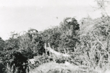
Photograph
This rectangle black and white photograph shows a bush scene with part of a suspension rope and wooden plank bridge visible in the middle of the image. It is likely this suspension bridge was used by the Tannery workers to move between the town and the Ovens Tannery located South-West of Beechworth due to its secluded bush location, the bridge likely spanned the gorge across Spring creek. The tannery itself was located alongside Gimlet Creek, about three kilometres from town, down what is now known as Malakoff and Old Tannery Road but which at the time was remote and accessed through bushland. The Ovens tannery was stablished in 1858 by Matthew Dodd and Hallahan and later Matthew and his brother Thomas Dodd in 1866 who developed it over the years. According to Doyle, 'we have little information about its early operations except the tannery itself comprised four small buildings' by 1870 ‘a small village with gardens of vines and fruit trees surrounded the tannery’ (Woods, 121), and by 1887 the Tannery employed fifteen men. The Ovens tannery was among several new businesses establishing themselves such as a foundry that brought industrial manufacturing alongside the developing township and which strengthened the economic stability of Beechworth after the receding mining surge. According to Woods (p. 121) in the 1860’s the government spent considerable sums to establish several public buildings such as the Benevolent Asylum, the Hospital and Insane Asylum to support those in need of care in the area directly after the Indigo gold rush which had left Beechworth, a fairly remote regional and newly formed township (Gold was first discovered in Beechworth in 1852) with a number of infirm and destitute people in its wake and which due to the support and establishment of these facilities ‘made Beechworth a significant social welfare centre in Victoria’ (Woods, p. 121). The tannery provided employment and connected the regional centre with other parts of Victoria and the wider colonial outposts and would have been a welcome opportunity for those seeking work after gold was no longer a source of income.A good example of the ingenuity of regional settlers to achieve what would have been a difficult and remote construction of a bridge as a means of access. This bridge is evidence of planning and forethought and shows dedication to establishing a life in a remote landscape.Black and white rectangular photograph printed on paperreverse: / 2983 / / BMM2983 /black and white photograph, bush, suspension bridge, rope bridge, tannery, spring creek, ovens tannery, bushland, gimlet creek, matthew dodd, beechworth -
 The Beechworth Burke Museum
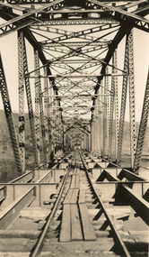
Photograph, c. 1927 - 1930
Taken during the construction of the Bethanga Bridge (1927-1930), this sepia photograph shows a view of the incomplete bridge taken from inside the structure and looking down the span of the bridge from where the photographer stands. The photograph depicts an incomplete deck, with loose-looking wooden planks/panels lain along the centre in groups of three. Once complete, the original decking of the bridge was made of timber before being replaced by cement in 1961 (Victorian Heritage Database).Bethanga Bridge is of historical significance to the Indigo Shire for its associations with the construction of Hume Dam, its associations with the River Murray Waters Agreement and the River Murray Commission, and illustration of the needs and influence of the farming communities along the river in this area - particularly in relation to the building of the Weir. It also represents the collaboration between New South Wales and Victoria on a large infrastructure project, being the only built structure shared by both New South Wales and Victoria due to its location. also reflecting on the Shire's geographical closeness to this neighboring state. This photograph is part of a series that documents the construction of this well-known heritage site of significance to the Indigo Shire. It reflects upon a period of growth and change in the area.Sepia, rectangular photograph printed on matt photographic paper, unmountedReverse: 1997.3190 / Another snap of the bridge. taken on the bridge showing huge steel sides / 84-19-4 / V [in circle] 354 / KODAK PRINTbethanga bridge, hume dam, bridges album, construction, road construction, hume weir -
 Orbost & District Historical Society
display book, 2001-2002
Kevin Parker was born in 1942 in Melbourne and studied Architecture at RMIT and from 1965-1990 worked as a freelance architectural illustrator. He continued this when he moved to Deddick in East Gippsland in 1991. In 2001 -2002 he began working on series of drawings about Mc Killops Bridge and environs for exhibition at Gippsland Art Gallery, Sale Victoria (Oct 2003). These drawings and prints feature McKillop's Bridge an the item is a compilation from a folder usually sold in the Slab Hut (Orbost Visitor Information Centre). A loose-leaf display book of copies of architectural style pencil drawings by Deddick artist, Kevin Parker. There is an introduction by Valerie Auer of Tubbut. The drawings are of McKillop's Bridge.parker-kevin drawings mckillop's-bridge display-book -
 Orbost & District Historical Society
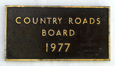
plaque, 1977
The Country Roads Board was the government authority for the construction and maintenance of main roads in Victoria between 1913 and 1983. It was succeeded by the Road Construction authority on 1 July 1983 and later merged with the Road Traffic Authority on July 1 1989 to form the Roads Corporation. James Cameron, an Orbost farming pioneer and Member of the Legislative Assembly, fathered the Country Roads Board. This plaque was possibly removed from a bridge(?) when the name was changed.A heavy rectangular shaped bronze plaque. the background is dark brown and the print and frame bronze coloured. On the back are two round recesses for screwing and attaching the plaque.COUNTRY ROADS BOARD 1977country-roads-board cameron-james -
 Orbost & District Historical Society
pamphlets, Princes Freeway - Orbost Section, 1976
Opened by the Hon. J A Rafferty, Minister for Transport, 25 November 1976, the bridge was the first of four bridges to be built as part of the freeway bypass of Orbost. Construction cost $2.4 million. This construction was an important development along the Princes Highway corridor through East Gippsland. The original highway approached the Snowy River at a very poor alignment, and several serious accidents had occurred at the Orbost end. In times of heavy flood, the highway on both sides of the river had been cut by floodwaters and during the 1971 floods, the highest ever recorded, the river was a mile wide at the crossing. Construction of the bridges commenced in January 1975, with an expectation to open the bridge across the Snowy River as soon as possible. Less than two years later, on 25 November 1976, the bridge across the Snowy River was opened to traffic, allowing the old bridge to be demolished. The remainder of the Orbost Bypass, both the floodplain crossings and the eastern section around the township itself, was declared ‘Princes Freeway’ and opened to traffic in December 1977. (ref http://mrv.ozroads.com.au) The Country Roads Board was the government authority for the construction and maintenance of main roads in Victoria between 1913 and 1983. It was succeeded by the Road Construction authority on 1 July 1983 and later merged with the Road Traffic Authority on July 1 1989 to form the Roads Corporation. James Cameron, an Orbost farming pioneer and Member of the Legislative Assembly, fathered the Country Roads Board. The opening of this Snowy River Bridge was an important development in the accessibility to the township of Orbost.Three coloured Country Roads pamphlets for the 'Princes Freeway - Orbost Section". On the front is a coloured photograph of the new construction over the Snowy River at Orbost. Inside is a program for a ceremony for the opening of the new Snowy River Bridge. There is also a black print map of the project. -
 Orbost & District Historical Society
book, Snowy River Mail as "Mail" Print, Princes Freeway Orbost Section, 2117.1 : 1976 2117.2 : 4.9.2013
... The Snowy River Bridge, Princes Freeway, Orbost, Victoria... gippsland The Snowy River Bridge, Princes Freeway, Orbost, Victoria ...The Snowy River Bridge, Princes Freeway, Orbost, Victoria was opened by the Hon. J A Rafferty, Minister for Transport, 25 November 1976. ‘The bridge was built at a cost of A$2.4 million and is the first of four bridges to be built as part of the 8.4 kilometre freeway bypass of Orbost. Construction of the bridges commenced in January 1975, with an expectation to open the bridge across the Snowy River as soon as possible. Less than two years later, on 25 November 1976, the bridge across the Snowy River was opened to traffic, allowing the old bridge to be demolished. The remainder of the Orbost Bypass, both the floodplain crossings and the eastern section around the township itself, was declared ‘Princes Freeway’. The newspaper article was written by David Jellie as part of the centenary celebrations of Vic Roads/Country Roads on 4.9.2013. David Jellie was the project engineer for the Snowy River Crossing Project.This book and article contain historical information and details about the construction of the bridges on the Orbost section of the Princes Freeway.2117.1 isaA thin paperbook book which contains a map, history and construction details of the Princes Freeway at Orbost. It has a program for the opening ceremony of the snowy River Bridge in 1976. 2117.2 is an article from the snowy River Mail on the history of the highway. It is dated 4.9.2013.In pencil - 20csnowy-river-bridge jellie-david princes-freeway-orbost -
 Orbost & District Historical Society
black and white photograph, first half 20th century
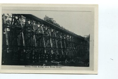
The Stony Creek Trestle Bridge was built in 1916 when the existing rail line from Melbourne to Bairnsdale was extended to Orbost. This 97km Bairnsdale to Orbost extension through rugged terrain was reputed to have been the most difficult rail project undertaken in Victoria. In service for over 60 years the bridge was damaged by bushfire in 1980, with the last train crossing in 1987. At 247m long and 20m high, it is the largest standing bridge of its kind in the State, and is listed on the Register of Historic Sites. Built of red ironbark and grey box timber, it is a fine example of the early engineering skills that utilised the resources and materials found on site.The Bairnsdale to Orbost rail line contains the most varied range of timber & timber composite bridges on any Victorian line. The Stoney Creek bridge is listed on the Victorian Heritage Register for its architectural and historical significance. A black / white photograph of a very tall wooden railway bridge with a train along the top.railway-bridge stoney-creek-bridge east-gippsland-railway -
 Orbost & District Historical Society
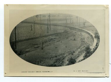
black and white photograph, Vogt. W.S, first half 20th century
In 1912 work was underrway on the Bairnsdale to Orbost railway. It was opened on April 10 1916. The two bridges on the railway viaduct, which crosses the Snowy River floodplain at Orbost, were built from local Southern Mahogany. The bridge on the Bairnsdale end (770m) is now the longest in Victoria. (info. Helen Martin)This item is associated with the history of the Orbost-Bairnsdale railway line and therefore reflects the role that the rail line played in the social and economic history of Orbost.A black / white photograph, oval-shaped on white background. It is of the railway viaduct across the flats at Orbost,.photo caption -"ORBOST RAILWAY BRIDGE, NEWMERELLA E. S. Vogt, Bairnsdale"newmerella orbost-viaduct east-gipsland-railway -
 Orbost & District Historical Society
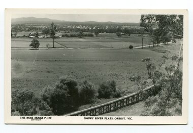
black and white photograph, Rose Stereograph Company, first half 20th century
The two bridges on the railway viaduct, which crosses the Snowy River floodplain at Orbost, were built from local Southern Mahogany. The bridge on the Bairnsdale end (770m) is now the longest in Victoria. Despite various attempts to extend the line, the station stayed on the western side of the Snowy River. (info. Helen Martin)This item is associated with the history of the Orbost-Bairnsdale railway line and therefore reflects the role that the rail line played in the social and economic history of Orbost.A black / white photograph / postcard of the Orbost township in the background and the railway viaduct over the flats in the foreground.photo caption - The Rose Series P.479 copywright SNOWY RIVER FLATS, ORBOST, VIC"east-gippsland-railway orbost-viaduct -
 Orbost & District Historical Society
black and white photograph, early 20th century - 1910?
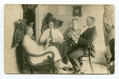
From L-R : Nathan Spielvogel, Hector Young, Percy Watt and George Holden. . Taken on the front porch at Illfracombe in 1908 after the four men had enjoyed a weekend fishing There appears to be a photo hanging on the wall in the background which looks like it could be of a young Marion Watt and the family's dog, a golden retriever In "The Gum Sucker at Home: Bound for Croajingolong 1908" by Nathan Spielvogel, published in Mary Gilbert's Personalities and Stories of the Early Orbost District, 3rd edition, p. 107-116, Spielvogel talks of his trip to Orbost, and fishing with Watt, Bruce and Young aboard Percy Watt's boat, the Maris Stella. Spielvogel's story says Young was the secretary at James & Birds auctioneers and "was one of the builders of the first foot bridge over the Backwater". It says George Holden was a Bank Manager at the Bank of Victoria. (info. from Campbell Watt) This photograph shows Mr Nathan Spielvogel on the left. He was a school teacher at the Orbost State School following Mr Rowe. Nathan Frederick Spielvogel (1874-1956), teacher, writer and historian, was born on 10 May 1874 at Ballarat, Victoria, son of Newman Frederick Spielvogel, pawnbroker, and his wife Hannah, née Cohen. As well as his stories he published a number of books about the history of Ballarat. Spielvogel taught at Orbost for at least a year Nathan Frederick Spielvogel (1874–1956) was a teacher, writer and historian. As a country schoolteacher, he traveled widely in the eastern Australian outback and also made a journey to London. Spielvogel gained distinction as one of the only Australian Jewish writers of his time. Many of his early books were best-sellers. He has an association with the history of Orbost having spent a year as a teacher at Orbost. The Watt family were early Marlo settlers.A black / white photograph / postcard of four men sitting around a small table playing cards. Two of the men have pillows behind their heads. Three are smoking pipes.on back - "On R - N. Spielvogel"spielvogel-nathan-orbost -
 Orbost & District Historical Society
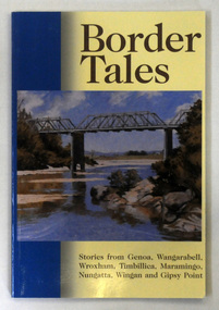
book, Border Tales, 2000
The book was compiled by Peter Allard and Geoff Alves and published by the Genoa Town Committee. Genoa is a small town in East Gippsland, Victoria. It is close to the New South Wales border where the Princes Highway crosses the Genoa River.A paperback book of 120pp titled Border tales : stories from Genoa, Wangarabell, Wroxham, Timbillica, Maramingo, Nungatta, Wingan and Gipsy Point. On the front cover is a coloured picture of the bridge across the Genoa river at Genoa. -
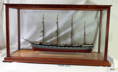 Flagstaff Hill Maritime Museum and Village
Craft - Ship Model, Falls of Halladale
The iron-hulled, four-masted barque, the Falls of Halladale, was a bulk carrier of general cargo. She left New York on August 1908 on her way to Melbourne and Sydney. In her hold, along with 56,763 tiles of unusual beautiful green American slates (roofing tiles), 5,673 coils of barbed wire, 600 stoves, 500 sewing machines, 6500 gallons of oil, 14400 gallons of benzene, and many other manufactured items, were 117 cases of crockery and glassware. Three months later and close to her destination, a navigational error caused the Falls of Halladale to be wrecked on a reef off the Peterborough headland at 3 am on the morning of the 15th of November, 1908. The captain and 29 crew members all survived, but her valuable cargo was largely lost, despite two salvage attempts in 1908-09 and 1910. ABOUT THE ‘FALLS OF HALLADALE’ (1886 - 1908) Built: in1886 by Russell & Co., Greenock shipyards, River Clyde, Scotland, UK. The company was founded in 1870 (or 1873) as a partnership between Joseph Russell (1834-1917), Anderson Rodger and William Todd Lithgow. During the period 1882-92 Russell & Co., standardised designs, which sped up their building process so much that they were able to build 271 ships over that time. In 1886 they introduced a 3000 ton class of sailing vessel with auxiliary engines and brace halyard winches. In 1890 they broke the world output record. Owner: Falls Line, Wright, Breakenridge & Co, 111 Union Street, Glasgow, Scotland. Configuration: Four masted sailing ship; iron-hulled barque; iron masts, wire rigging, fore & aft lifting bridges. Size: Length 83.87m x Breadth 12.6m x Depth 7.23m, Gross tonnage 2085 ton Wrecked: the night of 14th November 1908, Curdies Inlet, Peterborough south west Victoria Crew: 29 The Falls of Halladale was a four-masted sailing ship built-in 1886 in Glasgow, Scotland, for the long distance cargo trade and was mostly used for Pacific grain trade. She was owned by Wright, Breakenridge & Co of Glasgow and was one of several Falls Line ships, all of which were named after waterfalls in Scotland. The lines flag was of red, blue and white vertical stripes. The Falls of Halladale had a sturdy construction built to carry maximum cargo and able to maintain full sail in heavy gales, one of the last of the ‘windjammers’ that sailed the Trade Route. She and her sister ship, the Falls of Garry, were the first ships in the world to include fore and aft lifting bridges. Previous to this, heavily loaded vessels could have heavy seas break along the full length of the deck, causing serious injury or even death to those on deck. The new, raised catwalk-type decking allowed the crew to move above the deck stormy conditions. This idea is still used today on the most modern tankers and cargo vessels and has proved to be an important step forward in the safety of men at sea. On 4th August 1908, with new sails, 29 crew, and 2800 tons of cargo, the Falls of Halladale left New York, bound for Melbourne and Sydney via the Cape of Good Hope. The cargo on board was valued at £35,000 and included 56,763 tiles of American slate roofing tiles (roof slates), 5,673 coils of barbed wire, 600 stoves, 500 sewing machines, 6,500 gallons of oil, 14,400 gallons of benzene, plumbing iron, 117 cases of crockery and glassware and many other manufactured items. The Falls of Halladale had been at sail for 102 days when, at 3 am on the night of 14th November 1908, under full sail in calm seas with a six knots breeze behind and misleading fog along the coast, the great vessel rose upon an ocean swell and settled on top of a submerged reef near Peterborough on the south-west Victoria’s coast. The ship was jammed on the rocks and began filling with water. The crew launched the two lifeboats and all 29 crew landed safely on the beach over 4 miles away at the Bay of Islands. The postmistress at Peterborough, who kept a watch for vessels in distress, saw the stranding and sent out an alert to the local people. A rescue party went to the aid of the sailors and the Port Campbell rocket crew was dispatched, but the crew had all managed to reach shore safely by the time help arrived. The ship stayed in full sail on the rocky shelf for nearly two months, attracting hundreds of sightseers who watched her slowly disintegrate until the pounding seas and dynamiting by salvagers finally broke her back, and her remains disappeared back into deeper water. The valuable cargo was largely lost, despite two salvage attempts in 1908-09 and 1910. Further salvage operations were made from 1974-1986, during which time 22,000 slate tiles were recovered with the help of 14 oil drums to float them, plus personal artefacts, ship fittings, reams of paper and other items. The Court of Marine Inquiry in Melbourne ruled that the foundering of the ship was entirely due to Captain David Wood Thomson’s navigational error, not too technical failure of the Clyde-built ship. The shipwreck is a popular site for divers, about 300m offshore and in 3 – 15m of water. Some of the original cargo can be seen at the site, including pieces of roof slate and coils of barbed wire. The Falls of Halladale shipwreck is listed on the Victorian Heritage Register (No. S255). She was one of the last ships to sail the Trade Routes. She is one of the first vessels to have fore and aft lifting bridges. She is an example of the remains of an International Cargo Ship and also represents aspects of Victoria’s shipping industry. The wreck is protected as a Historic Shipwreck under the Commonwealth Historic Shipwrecks Act (1976). The Falls of Halladale shipwreck is listed on the Victorian Heritage Register (No. S255). She was one of the last ships to sail the Trade Routes. She is one of the first vessels to have fore and aft lifting bridges. She is an example of the remains of an International Cargo Ship and also represents aspects of Victoria’s shipping industry. The wreck is protected as a Historic Shipwreck under the Commonwealth Historic Shipwrecks Act (1976).Model Falls of Halladale, good condition in a glass case. falls of halladale, wright, breakenridge & co of glasgow, californian blue roof slate, warrnambool, shipwrecked-coast, flagstaff-hill, flagstaff-hill-maritime-museum, maritime-museum, shipwreck-coast, flagstaff-hill-maritime-village, shipwrecked-artefact, ships model, 1908 shipwreck, great clipper ships -
 Flagstaff Hill Maritime Museum and Village
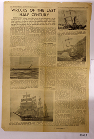
Newspaper - Newspaper clipping, 22-03-1947
Newspaper clippings and a typed sheet regarding shipwrecks in South West Victoria. (1) The first clipping is titled Wrecks of the Last Half Century, page 12 of the Warrnambool Centenary Supplement, The Warrnambool Standard, Saturday, March 22, 1947. The ships mentioned are FREE TRADER, LA BELLA, FALLS OF HALLADALE, CASINO and CARAMBA. (2) The second clipping's main article Divers Find old shipwreck from Geoff Clancy has a handwritten date Circa Jan 30, 1960, and is possibly from a Melbourne newspaper, as it mentions non-local events. It tells of the then-current finding of the 52-year-old wreck of the Falls of Halladale near Port Campbell by skin divers. (3) Type is written 2-page article The Romance of the Clipper Ships by Basil Lubbock sub-title Falls of Halladale. The iron-hulled, four-masted barque, the Falls of Halladale, was a bulk carrier of general cargo. She left New York in August 1908 on her way to Melbourne and Sydney. In her hold, along with 56,763 tiles of unusual beautiful green American slates (roofing tiles), 5,673 coils of barbed wire, 600 stoves, 500 sewing machines, 6500 gallons of oil, 14400 gallons of benzene, and many other manufactured items, were 117 cases of crockery and glassware. Three months later and close to her destination, a navigational error caused the Falls of Halladale to be wrecked on a reef off the Peterborough headland at 3 am on the morning of the 15th of November, 1908. The captain and 29 crew members all survived, but her valuable cargo was largely lost, despite two salvage attempts in 1908-09 and 1910. ABOUT THE ‘FALLS OF HALLADALE’ (1886 - 1908): - Built: in1886 by Russell & Co., Greenock shipyards, River Clyde, Scotland, UK. The company was founded in 1870 (or 1873) as a partnership between Joseph Russell (1834-1917), Anderson Rodger and William Todd Lithgow. During the period 1882-92 Russell & Co. they standardised designs, which sped up their building process so much that they were able to build 271 ships over that time. In 1886 they introduced a 3000 ton class of sailing vessel with auxiliary engines and brace halyard winches. In 1890 they broke the world output record. Owner: Falls Line, Wright, Breakenridge & Co, 111 Union Street, Glasgow, Scotland. Configuration: Four masted sailing ship; iron-hulled barque; iron masts, wire rigging, fore & aft lifting bridges. Size: Length 83.87m x Breadth 12.6m x Depth 7.23m, Gross tonnage 2085 ton Wrecked: the night of 14th November 1908, Curdies Inlet, Peterborough south west Victoria Crew: 29 The Falls of Halladale was a four-masted sailing ship built-in 1886 in Glasgow, Scotland, for the long-distance cargo trade and was mostly used for Pacific grain trade. She was owned by Wright, Breakenridge & Co of Glasgow and was one of several Falls Line ships, all of which were named after waterfalls in Scotland. The lines flag was of red, blue and white vertical stripes. The Falls of Halladale had a sturdy construction built to carry maximum cargo and able to maintain full sail in heavy gales, one of the last of the ‘windjammers’ that sailed the Trade Route. She and her sister ship, the Falls of Garry, were the first ships in the world to include fore and aft lifting bridges. Previous to this, heavily loaded vessels could have heavy seas break along the full length of the deck, causing serious injury or even death to those on deck. The new, raised catwalk-type decking allowed the crew to move above the deck stormy conditions. This idea is still used today in the most modern tankers and cargo vessels and has proved to be an important step forward in the safety of men at sea. On 4th August 1908, with new sails, 29 crew, and 2800 tons of cargo, the Falls of Halladale left New York, bound for Melbourne and Sydney via the Cape of Good Hope. The cargo on board was valued at £35,000 and included 56,763 tiles of American slate roofing tiles (roof slates), 5,673 coils of barbed wire, 600 stoves, 500 sewing machines, 6,500 gallons of oil, 14,400 gallons of benzene, plumbing iron, 117 cases of crockery and glassware and many other manufactured items. The Falls of Halladale had been at sail for 102 days when, at 3 am on the night of 14th November 1908, under full sail in calm seas with a six knots breeze behind and misleading fog along the coast, the great vessel rose upon an ocean swell and settled on top of a submerged reef near Peterborough on south-west Victoria’s coast. The ship was jammed on the rocks and began filling with water. The crew launched the two lifeboats and all 29 crew landed safely on the beach over 4 miles away at the Bay of Islands. The postmistress at Peterborough, who kept a watch for vessels in distress, saw the stranding and sent out an alert to the local people. A rescue party went to the aid of the sailors and the Port Campbell rocket crew was dispatched, but the crew had all managed to reach shore safely by the time help arrived. The ship stayed in full sail on the rocky shelf for nearly two months, attracting hundreds of sightseers who watched her slowly disintegrate until the pounding seas and dynamiting by salvagers finally broke her back, and her remains disappeared back into deeper water. The valuable cargo was largely lost, despite two salvage attempts in 1908-09 and 1910. Further salvage operations were made from 1974-1986, during which time 22,000 slate tiles were recovered with the help of 14 oil drums to float them, plus personal artefacts, ship fittings, reams of paper and other items. The Court of Marine Inquiry in Melbourne ruled that the foundering of the ship was entirely due to Captain David Wood Thomson’s navigational error, not too technical failure of the Clyde-built ship. The shipwreck is a popular site for divers, about 300m offshore and in 3 – 15m of water. Some of the original cargo can be seen at the site, including pieces of roof slate and coils of barbed wire.The newspaper articles are of historical significance, retelling the stories of shipwrecks along the South West coast of Victoria. The Falls of Halladale shipwreck is listed on the Victorian Heritage Register (No. S255). She was one of the last ships to sail the Trade Routes. She is one of the first vessels to have fore and aft lifting bridges. She is an example of the remains of an International Cargo Ship and also represents aspects of Victoria’s shipping industry. The wreck is protected as a Historic Shipwreck under the Commonwealth Historic Shipwrecks Act (1976).Newspaper cuttings with text and photographs (3) relevant to Falls of Halladale, La Bella, Casino, Free Trader and the refurbishing of the Falls of Clyde. Also included is typewritten information about Falls of Halladale. Printed between 1947 and 1972 in Melbourne, Victoria Author of the typed article "The Romance of the Clipper Ships" was Basil Lubbock Handwritten on article "Circa: JAN 30 1960" Headline "Divers find old shipwreck" "Geoff Clancy" "Not salvaged" "Still wedged" "Falls of Halladale" Typed pages: "THE ROMANCE OF THE CLIPPER SHIPS BY BASIL LUBBOCK" "FALLS OF HALLADALE" flagstaff hill, warrnambool, shipwrecked-coast, flagstaff-hill, flagstaff-hill-maritime-museum, maritime-museum, shipwreck-coast, flagstaff-hill-maritime-village, falls of halladale, la bella, falls of clyde, freetrader, casino, coramba, geoff clancy, warrnambool standard january 30 1947, warrnambool centenary supplement 1947, wrecks of the last half century, newspaper article divers find by geoff clancy, the romance of the clipper ships by basil lubbock, free trader, speculant, clipper ship, shipwrecks -
 Flagstaff Hill Maritime Museum and Village
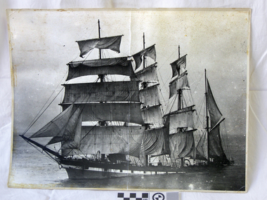
Photograph
The iron-hulled, four-masted barque, the Falls of Halladale, was a bulk carrier of general cargo. She left New York in August 1908 on her way to Melbourne and Sydney. In her hold, along with 56,763 tiles of unusual beautiful green American slates (roofing tiles), 5,673 coils of barbed wire, 600 stoves, 500 sewing machines, 6500 gallons of oil, 14400 gallons of benzene, and many other manufactured items, were 117 cases of crockery and glassware. Three months later and close to her destination, a navigational error caused the Falls of Halladale to be wrecked on a reef off the Peterborough headland at 3 am on the morning of the 15th of November, 1908. The captain and 29 crew members all survived, but her valuable cargo was largely lost, despite two salvage attempts in 1908-09 and 1910. ABOUT THE ‘FALLS OF HALLADALE’ (1886 - 1908) Built: in1886 by Russell & Co., Greenock shipyards, River Clyde, Scotland, UK. The company was founded in 1870 (or 1873) as a partnership between Joseph Russell (1834-1917), Anderson Rodger and William Todd Lithgow. During the period 1882-92 Russell & Co., they standardised designs, which sped up their building process so much that they were able to build 271 ships over that time. In 1886 they introduced a 3000 ton class of sailing vessel with auxiliary engines and brace halyard winches. In 1890 they broke the world output record. Owner: Falls Line, Wright, Breakenridge & Co, 111 Union Street, Glasgow, Scotland. Configuration: Four masted sailing ship; iron-hulled barque; iron masts, wire rigging, fore & aft lifting bridges. Size: Length 83.87m x Breadth 12.6m x Depth 7.23m, Gross tonnage 2085 ton Wrecked: the night of 14th November 1908, Curdies Inlet, Peterborough south west Victoria Crew: 29 The Falls of Halladale was a four-masted sailing ship built-in 1886 in Glasgow, Scotland, for the long-distance cargo trade and was mostly used for Pacific grain trade. She was owned by Wright, Breakenridge & Co of Glasgow and was one of several Falls Line ships, all of which were named after waterfalls in Scotland. The lines flag was of red, blue and white vertical stripes. The Falls of Halladale had a sturdy construction built to carry maximum cargo and able to maintain full sail in heavy gales, one of the last of the ‘windjammers’ that sailed the Trade Route. She and her sister ship, the Falls of Garry, were the first ships in the world to include fore and aft lifting bridges. Previous to this, heavily loaded vessels could have heavy seas break along the full length of the deck, causing serious injury or even death to those on deck. The new, raised catwalk-type decking allowed the crew to move above the deck stormy conditions. This idea is still used today in the most modern tankers and cargo vessels and has proved to be an important step forward in the safety of men at sea. On 4th August 1908, with new sails, 29 crew, and 2800 tons of cargo, the Falls of Halladale left New York, bound for Melbourne and Sydney via the Cape of Good Hope. The cargo on board was valued at £35,000 and included 56,763 tiles of American slate roofing tiles (roof slates), 5,673 coils of barbed wire, 600 stoves, 500 sewing machines, 6,500 gallons of oil, 14,400 gallons of benzene, plumbing iron, 117 cases of crockery and glassware and many other manufactured items. The Falls of Halladale had been at sail for 102 days when, at 3 am on the night of 14th November 1908, under full sail in calm seas with a six knots breeze behind and misleading fog along the coast, the great vessel rose upon an ocean swell and settled on top of a submerged reef near Peterborough on south-west Victoria’s coast. The ship was jammed on the rocks and began filling with water. The crew launched the two lifeboats and all 29 crew landed safely on the beach over 4 miles away at the Bay of Islands. The postmistress at Peterborough, who kept a watch for vessels in distress, saw the stranding and sent out an alert to the local people. A rescue party went to the aid of the sailors and the Port Campbell rocket crew was dispatched, but the crew had all managed to reach shore safely by the time help arrived. The ship stayed in full sail on the rocky shelf for nearly two months, attracting hundreds of sightseers who watched her slowly disintegrate until the pounding seas and dynamiting by salvagers finally broke her back, and her remains disappeared back into deeper water. The valuable cargo was largely lost, despite two salvage attempts in 1908-09 and 1910. Further salvage operations were made from 1974-1986, during which time 22,000 slate tiles were recovered with the help of 14 oil drums to float them, plus personal artefacts, ship fittings, reams of paper and other items. The Court of Marine Inquiry in Melbourne ruled that the foundering of the ship was entirely due to Captain David Wood Thomson’s navigational error, not too technical failure of the Clyde-built ship. The shipwreck is a popular site for divers, about 300m offshore and in 3 – 15m of water. Some of the original cargo can be seen at the site, including pieces of roof slate and coils of barbed wire. The Falls of Halladale shipwreck is listed on the Victorian Heritage Register (No. S255). She was one of the last ships to sail the Trade Routes. She is one of the first vessels to have fore and aft lifting bridges. She is an example of the remains of an International Cargo Ship and also represents aspects of Victoria’s shipping industry. The wreck is protected as a Historic Shipwreck under the Commonwealth Historic Shipwrecks Act (1976).Photograph of Falls of Halladale fully rigged wrecked sailing ship. Written on back. "Bill Kelson 75 Macquarie Ave Padbury 6025" flagstaff hill, warrnambool, shipwrecked-coast, flagstaff-hill, flagstaff-hill-maritime-museum, maritime-museum, shipwreck-coast, flagstaff-hill-maritime-village, falls of halladale -
 Flagstaff Hill Maritime Museum and Village
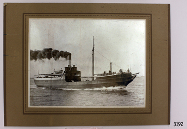
Photograph, after 1890
This photograph was donated by Mrs Nancy Mason, daughter-in-law of the last owner, Arnold Mason, who had been given the photograph by Mr. Mac Fordham, who was Chief Engineer of the SS Edina. Both men had been Engineers in WW I. The configuration of the SS Edina in the photograph is post 1890. ABOUT THE S S EDINA The three masted iron screw steamer SS Edina was built in Glasgow, Scotland, in 1854 by Barclay and Curle. She was adorned with the figurehead of ‘fair maid of Judea’. The many years of service made SS Edina famous world-wide as the longest serving screw steamer. (The term screw steamer comes from being driven by a single propeller, sometimes called a screw, driven by a steam engine.) SS Edina’s interesting history includes English Chanel runs, serving in the Crimean Ware carrying ammunition, horses and stores to the Black Sea, and further service in the American Civil War and later, serving in the western district of Victoria as well as in Queensland and carried gold, currency and gold prospectors Australia to New Zealand. SS Edina had the privilege of being an escort vessel to H.R.H. the Duke of Edinburgh during his visit to Australia in 1867. In March 1863 SS Edina arrived in Port Phillip Bay, Melbourne and was bought by Stephen Henty, of Portland fame, to work the cargo and passenger run from Melbourne – Warrnambool – Port Fairy - Portland. After a short time of working the run from Australia to New Zealand, with passengers and cargo that included gold and currency, she returned to her Melbourne - Warrnambool – Port Fairy run, with cargo including bales of wool produced in the western district of Victoria. The Warrnambool Steam Packet Company purchased SS Edina in 1867; she was now commanded by Captain John Thompson and Chief Engineer John Davies. She survived several mishaps at sea, had a complete service and overhaul and several changes of commanders. In 1870 SS Edina was in Lady Bay, Warrnambool, when a gale sprung up and caused a collision with the iron screw steamer SS Dandenong. SS Edina’s figurehead was broken into pieces and it was not ever replaced. SS Edina was re-fitted in 1870 then was used as a coastal trader in Queensland for a period. She was then brought to Melbourne to carry cargo and passengers between Melbourne and Geelong and performed this service 1880-1938. During this time (1917) she was again refitted with a new mast, funnel, bridge and promenade deck, altering her appearance. In 1938, after more collisions, SS Edina was taken out of service. However she was later renamed Dinah and used as a ‘lighter’ (a vessel without engine or superstructure) to be towed and carry wool and general cargo between Melbourne and Geelong. In 1957, after 104 years, the SS Edina was broken up at Footscray, Melbourne. Remains of SS Edina’s hull can be found in the Maribyrnong River, Port Phillip Bay. [Reference: A Brief Review of Steam Navigation in Victoria; C Dickson Gregory; Centenary Maritime Exhibition catalogue, 1934; published by Shiplovers' Society of Victoria Dandenong, Passengers in History, http://passengersinhistory.sa.gov.au/node/924034 Edina, Victorian Heritage Database VHR S199 http://vhd.heritage.vic.gov.au/shipwrecks/heritage/199 SS Edina, Coastal Trader and Passenger Ship 1853-1938, Museum Victoria Collections, https://collections.museumvictoria.com.au/articles/6227 SS ‘Edina’ – the Longest Serving Screw Steamer in the World, POI Australia, https://poi-australia.com.au/ss-edina-the-longest-serving-steamer-in-the-world/ ]This photograph of the SS Edina is significant for its association with the screw steamer SS Edina. The SS Edina is heritage listed on the Victorian Heritage Database VHR S199. She had endeared herself to the people of Port Phillip Bay as a passenger ferry, part of their history and culture. She played a significant role in the Crimean War, the American Civil War and the gold rush in New Zealand. She also served western Victoria for many years in her cargo and passenger runs. The SS Edina is famous for being the longest serving screw steamer in the world. After spending her first nine years overseas she arrived in Melbourne and her work included running the essential service of transporting cargo and passengers between Melbourne and the western Victoria ports of Warrnambool, Port Fairy and Portland. The SS Edina was purchased in the late 1860’s by local Warrnambool business, the Warrnambool Steam Packet Co. and continued trading from there as part of the local business community. The SS Edina’s original ‘fair maid of Judea’ figurehead was broken to pieces in a collision with another vessel (the SS Dandenong) in a gale off Warrnambool, Victoria, in 1870.Black and White photograph mounted on brown card of SS Edina. Inscription on reverse side. The photograph shows the SS Edina moving under steam power, many people on both the bow and stern and a few people in the centre of the vessel. There are buildings on the shore in the background. The ship's configuration is dated post 1890.warrnambool, shipwrecked coast, flagstaff hill, flagstaff hill maritime museum, maritime museum, shipwreck coast, flagstaff hill maritime village, shipwrecked artefact, barclay & curle, figurehead 'fair maid of judea', centenary maritime exhibition 1934, a brief review of steam navigation in victoria, pleasure steamer edina, trade and travel late 19th and early 20th century, trade melbourne to geelong, screw steamer edina, coastal trader edina, lighter dinah, cargo carrying for cremean war, cargo carrying for american civil war, passenger and trade in western district of victoria, export gold and currency and gold diggers to new zealand, export vessel to h r h the duke of edinburgh, melbourne - warrnambool - port fairy - portland cargo run, warrnambool steam packet company, stephen henty, captain john thompson, chief engineer john davies, lady bay warrnambool, lighter edina, shipping victoria, port phillip bay steamers, steamship great britain, edina, vhr s199 victorian heritage database, photograph of ss edina post 1890, photograph australian screw steamer, pleasure vessel victoria post 1890 -
 Flagstaff Hill Maritime Museum and Village
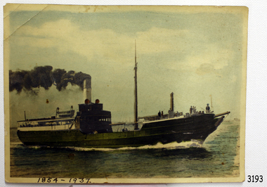
Photograph, Between 1890 - 19-12-1937
This photographic postcard of the SS Edina was taken after the 1890’s due to the style and configuration of the vessel. There is a black and white photograph of the same image also in our Collection (RN 3192). It is most likely that both of the photographs were donated by the same person because the people mentioned in the inscription on the black and white photograph’s reverse side connect with two of the people mentioned in the letter on the reverse of the coloured photograph. * RN 3192; Black & White photograph - inscription: "Donated by Mrs. Nancy Mason, Bay View. Owned by Mac Fordham, Chief Engineer, 'Edina', then given to Mrs. Mason's father-in-law Arnold Mason (both Engineers W.W. I)" The “Arnie” to whom the letter was addressed is likely to be Arnold Mason, Engineer. The author of the letter, “Mac”, is likely to be Mac Fordham, Chief Engineer of SS Edina. The transcribed letter tells of two men who know each other well and have an interest in the Edina. “Mac” mentions that he may be “too old” to be at sea again; this would also support the idea that the older writer would give his photographs to the perhaps younger “Arnie”. * RN 3193 (this photograph) - Transcription of pen and ink script handwriting = = = = = = = = = = = = 19-12-37 No. 1 Flat, “Goodwood Lodge” 196 Lennox Street, Richmond [Victoria] Dear Arnie , Been meaning to write for long time but you know, it’s just the usual routine of the seamen within Bay trades. Had a good trip back from Sydney. Took our time, spent almost a week coming back, rather monotonous in parts in the hill country, too many darn curves, still was a good trip. How are you all keeping? Suppose you’ve moved back to Drummoyne [erettris?], expect you can let the house in Manly easily enough. Noticed they had a strike at Cockatoo [Cockatoo Island NSW]. don’t suppose they pulled the boys out. How is Jack doing? Has [Willie?] commenced training yet, or no! too young, isn’t she? Been a lot of “paper” talk about the “Edina” finishing but nothing official that I’m aware of, but it’s always on the cards I suppose, then I suppose it will be to sea again if I’m not too old. Easy Winter only 3 trips per week, running every day from today until further notice. Trust [Mary?] Is well & all’s well with you too. Best wishes from us both for Xmas & New Year. Cheerio Mac = = = = = = = = = = = = ABOUT THE S S EDINA The three masted iron screw steamer SS Edina was built in Glasgow, Scotland, in 1854 by Barclay and Curle. She was adorned with the figurehead of ‘fair maid of Judea’. The many years of service made SS Edina famous world-wide as the longest serving screw steamer. (The term screw steamer comes from being driven by a single propeller, sometimes called a screw, driven by a steam engine.) SS Edina’s interesting history includes English Chanel runs, serving in the Crimean Ware carrying ammunition, horses and stores to the Black Sea, and further service in the American Civil War and later, serving in the western district of Victoria as well as in Queensland and carried gold, currency and gold prospectors Australia to New Zealand. SS Edina had the privilege of being an escort vessel to H.R.H. the Duke of Edinburgh during his visit to Australia in 1867. In March 1863 SS Edina arrived in Port Phillip Bay, Melbourne and was bought by Stephen Henty, of Portland fame, to work the cargo and passenger run from Melbourne – Warrnambool – Port Fairy - Portland. After a short time of working the run from Australia to New Zealand, with passengers and cargo that included gold and currency, she returned to her Melbourne - Warrnambool – Port Fairy run, with cargo including bales of wool produced in the western district of Victoria. The Warrnambool Steam Packet Company purchased SS Edina in 1867; she was now commanded by Captain John Thompson and Chief Engineer John Davies. She survived several mishaps at sea, had a complete service and overhaul and several changes of commanders. In 1870 SS Edina was in Lady Bay, Warrnambool, when a gale sprung up and caused a collision with the iron screw steamer SS Dandenong. SS Edina’s figurehead was broken into pieces and it was not ever replaced. SS Edina was re-fitted in 1870 then was used as a coastal trader in Queensland for a period. She was then brought to Melbourne to carry cargo and passengers between Melbourne and Geelong and performed this service 1880-1938. During this time (1917) she was again refitted with a new mast, funnel, bridge and promenade deck, altering her appearance. In 1938, after more collisions, SS Edina was taken out of service. However she was later renamed Dinah and used as a ‘lighter’ (a vessel without engine or superstructure) to be towed and carry wool and general cargo between Melbourne and Geelong. In 1957, after 104 years, the SS Edina was broken up at Footscray, Melbourne. Remains of SS Edina’s hull can be found in the Maribyrnong River, Port Phillip Bay. [Reference: A Brief Review of Steam Navigation in Victoria; C Dickson Gregory; Centenary Maritime Exhibition catalogue, 1934; published by Shiplovers' Society of Victoria Dandenong, Passengers in History, http://passengersinhistory.sa.gov.au/node/924034 Edina, Victorian Heritage Database VHR S199 http://vhd.heritage.vic.gov.au/shipwrecks/heritage/199 SS Edina, Coastal Trader and Passenger Ship 1853-1938, Museum Victoria Collections, https://collections.museumvictoria.com.au/articles/6227 SS ‘Edina’ – the Longest Serving Screw Steamer in the World, POI Australia, https://poi-australia.com.au/ss-edina-the-longest-serving-steamer-in-the-world/ ]This photographic postcard with the letter on the revers tell about the SS Edina and are significant for its association with the screw steamer SS Edina. The SS Edina is heritage listed on the Victorian Heritage Database VHR S199. She had endeared herself to the people of Port Phillip Bay as a passenger ferry, part of their history and culture. She played a significant role in the Crimean War, the American Civil War and the gold rush in New Zealand. She also served western Victoria for many years in her cargo and passenger runs. The SS Edina is famous for being the longest serving screw steamer in the world. After spending her first nine years overseas she arrived in Melbourne and her work included running the essential service of transporting cargo and passengers between Melbourne and the western Victoria ports of Warrnambool, Port Fairy and Portland. The SS Edina was purchased in the late 1860’s by local Warrnambool business, the Warrnambool Steam Packet Co. and continued trading from there as part of the local business community. The SS Edina’s original ‘fair maid of Judea’ figurehead was broken to pieces in a collision with another vessel (the SS Dandenong) in a gale off Warrnambool, Victoria, in 1870.Coloured (hand coloured) photographic postcard of SS Edina. Letter on reverse, hand written in pen and ink, from Mac to Arnie, dated 19-12-37 [1937]. The photograph shows the SS Edina moving under steam power, many people on both the bow and stern and a few people in the centre of the vessel. There are buildings on the shore in the background. The ship's configuration is dated post 1890.Hand written in pen on base of front “1854-1957” Hand written on back in blue pen and crossed out “REC 409” Hand written on back in pen ‘EDINA,’ “3173,” “086.2” Hand written letter dated 19-12-37, from Mac to Arnie. Script writing in pen and ink letter on reverse of photograph – see “Context” section for transcription. warrnambool, shipwrecked coast, flagstaff hill, flagstaff hill maritime museum, maritime museum, shipwreck coast, flagstaff hill maritime village, shipwrecked artefact, barclay & curle, figurehead 'fair maid of judea', centenary maritime exhibition 1934, a brief review of steam navigation in victoria, pleasure steamer edina, trade and travel late 19th and early 20th century, trade melbourne to geelong, screw steamer edina, coastal trader edina, lighter dinah, cargo carrying for cremean war, cargo carrying for american civil war, passenger and trade in western district of victoria, export gold and currency and gold diggers to new zealand, export vessel to h r h the duke of edinburgh, melbourne - warrnambool - port fairy - portland cargo run, warrnambool steam packet company, stephen henty, captain john thompson, chief engineer john davies, lady bay warrnambool, lighter edina, shipping victoria, port phillip bay steamers, steamship great britain, edina, vhr s199 victorian heritage database, photographic postcard of ss edina 1854-1957, letter by mac fordham chief engineer ss edina, letter to arnold mason, engineer -
 Flagstaff Hill Maritime Museum and Village
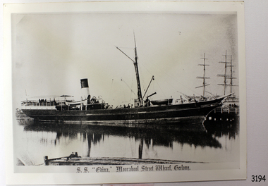
Photograph, S.S. "EDINA," Moorabool Street Wharf, Geelong, c. 1870's - 1930's
This black and white photograph was taken when the SS Edina was as port at the Gellong Wharf in Moorabool Street. The Port of Geelong had many wool sheds alongside the wharf - wool was a major export product. ABOUT THE S S EDINA The three masted iron screw steamer SS Edina was built in Glasgow, Scotland, in 1854 by Barclay and Curle. She was adorned with the figurehead of ‘fair maid of Judea’. The many years of service made SS Edina famous world-wide as the longest serving screw steamer. (The term screw steamer comes from being driven by a single propeller, sometimes called a screw, driven by a steam engine.) SS Edina’s interesting history includes English Chanel runs, serving in the Crimean Ware carrying ammunition, horses and stores to the Black Sea, and further service in the American Civil War and later, serving in the western district of Victoria as well as in Queensland and carried gold, currency and gold prospectors Australia to New Zealand. SS Edina had the privilege of being an escort vessel to H.R.H. the Duke of Edinburgh during his visit to Australia in 1867. In March 1863 SS Edina arrived in Port Phillip Bay, Melbourne and was bought by Stephen Henty, of Portland fame, to work the cargo and passenger run from Melbourne – Warrnambool – Port Fairy - Portland. After a short time of working the run from Australia to New Zealand, with passengers and cargo that included gold and currency, she returned to her Melbourne - Warrnambool – Port Fairy run, with cargo including bales of wool produced in the western district of Victoria. The Warrnambool Steam Packet Company purchased SS Edina in 1867; she was now commanded by Captain John Thompson and Chief Engineer John Davies. She survived several mishaps at sea, had a complete service and overhaul and several changes of commanders. In 1870 SS Edina was in Lady Bay, Warrnambool, when a gale sprung up and caused a collision with the iron screw steamer SS Dandenong. SS Edina’s figurehead was broken into pieces and it was not ever replaced. SS Edina was re-fitted in 1870 then was used as a coastal trader in Queensland for a period. She was then brought to Melbourne to carry cargo and passengers between Melbourne and Geelong and performed this service 1880-1938. During this time (1917) she was again refitted with a new mast, funnel, bridge and promenade deck, altering her appearance. In 1938, after more collisions, SS Edina was taken out of service. However she was later renamed Dinah and used as a ‘lighter’ (a vessel without engine or superstructure) to be towed and carry wool and general cargo between Melbourne and Geelong. In 1957, after 104 years, the SS Edina was broken up at Footscray, Melbourne. Remains of SS Edina’s hull can be found in the Maribyrnong River, Port Phillip Bay. [Reference: A Brief Review of Steam Navigation in Victoria; C Dickson Gregory; Centenary Maritime Exhibition catalogue, 1934; published by Shiplovers' Society of Victoria Dandenong, Passengers in History, http://passengersinhistory.sa.gov.au/node/924034 Edina, Victorian Heritage Database VHR S199 http://vhd.heritage.vic.gov.au/shipwrecks/heritage/199 SS Edina, Coastal Trader and Passenger Ship 1853-1938, Museum Victoria Collections, https://collections.museumvictoria.com.au/articles/6227 SS ‘Edina’ – the Longest Serving Screw Steamer in the World, POI Australia, https://poi-australia.com.au/ss-edina-the-longest-serving-steamer-in-the-world/ ]This postcard of the SS Edina is significant for its association with the screw steamer SS Edina and shows her at one of her trading ports on the Melbourne - Warrnambool - Port Fairy - Portland run. The SS Edina is heritage listed on the Victorian Heritage Database VHR S199. She had endeared herself to the people of Port Phillip Bay as a passenger ferry, part of their history and culture. She played a significant role in the Crimean War, the American Civil War and the gold rush in New Zealand. She also served western Victoria for many years in her cargo and passenger runs. The SS Edina is famous for being the longest serving screw steamer in the world. After spending her first nine years overseas she arrived in Melbourne and her work included running the essential service of transporting cargo and passengers between Melbourne and the western Victoria ports of Warrnambool, Port Fairy and Portland. The SS Edina was purchased in the late 1860’s by local Warrnambool business, the Warrnambool Steam Packet Co. and continued trading from there as part of the local business community. The SS Edina’s original ‘fair maid of Judea’ figurehead was broken to pieces in a collision with another vessel (the SS Dandenong) in a gale off Warrnambool, Victoria, in 1870.Black and White photograph of S.S Edina at the Moorabool Street Wharf, Geelong in calm water that shows the reflection of the steamer. Ship has no sails raised. The funnel has a light coloured base with a dark coloured top. There are people on board the steamer. Other ship masts and people are in the background. In the foreground is a jetty with a small boat beside it and a person inside the boat. There is a title printed along the base of the photograph. c. 1870's to 1930'sPrinted at base of photograph "S.S. "EDINA," Moorabool Street Wharf, Geelong"warrnambool, shipwrecked coast, flagstaff hill, flagstaff hill maritime museum, maritime museum, shipwreck coast, flagstaff hill maritime village, shipwrecked artefact, barclay & curle, figurehead 'fair maid of judea', centenary maritime exhibition 1934, a brief review of steam navigation in victoria, pleasure steamer edina, trade and travel late 19th and early 20th century, trade melbourne to geelong, screw steamer edina, coastal trader edina, lighter dinah, cargo carrying for cremean war, cargo carrying for american civil war, passenger and trade in western district of victoria, export gold and currency and gold diggers to new zealand, export vessel to h r h the duke of edinburgh, melbourne - warrnambool - port fairy - portland cargo run, warrnambool steam packet company, stephen henty, captain john thompson, chief engineer john davies, lady bay warrnambool, lighter edina, shipping victoria, port phillip bay steamers, steamship great britain, edina, vhr s199 victorian heritage database, postcard of ss edina 1870's - 1930's -
 Flagstaff Hill Maritime Museum and Village
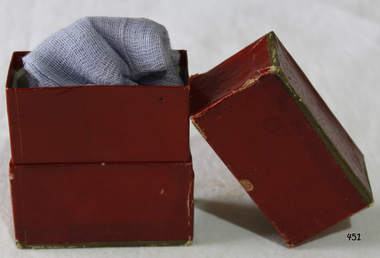
Equipment - Gauze & Box, Early - Mid 20th Century
When used as a medical dressing, woven gauze is usually made of cotton. It is especially useful for dressing wounds where other fabrics might stick to the burn or laceration. Many modern medical gauzes are covered with a perforated plastic film such as Telfa or a polyblend which prevents direct contact and further minimizes wound adhesion. Also, it can be impregnated with a thick, creamy mixture of zinc oxide and calamine to promote healing, as in Unna's boot. (An Unna’s boot is a special gauze (usually 4 inches wide and 10 yards long) bandage, which can be used for the treatment of venous stasis ulcers and other venous insufficiencies of the leg. It can also be used as a supportive bandage for sprains and strains of the foot, ankle and lower leg. The gauze is impregnated with a thick, creamy mixture of zinc oxide and calamine to promote healing. It may also contain acacia, glycerin, castor oil and white petrolatum.) Gauze is also used during procedures involving accidental tooth loss; either the gauze is used to provide pressure as the tooth is moved back into its corresponding socket, or the tooth is wrapped in gauze and placed in milk or saline to keep it alive while the tooth is being transported or prepared for reinsertion. https://en.wikipedia.org/wiki/GauzeAccess to emergency medical help in early settlement days of Victoria could take quite some time, especially in remote areas. From 1888 First Aid Kits and instructions became available for work sites, offices, community groups and individuals, helping to bridge the gap between the accident and the arrival of medical assistance. Gauze was widely used in many medical conditions.Gauze and maroon box with sliding top, purple bandage (gauze) inside. Gold rim top and bottom. None.flagstaff hill, warrnambool, shipwrecked-coast, flagstaff-hill, flagstaff-hill-maritime-museum, maritime-museum, shipwreck-coast, flagstaff-hill-maritime-village, first aid bandages, dressings, medical -
 Flagstaff Hill Maritime Museum and Village
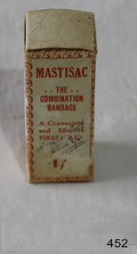
Equipment - Gauze & Box, Flexlock Products, Early - Mid 20th Century
When used as a medical dressing, woven gauze is usually made of cotton. It is especially useful for dressing wounds where other fabrics might stick to the burn or laceration. Many modern medical gauzes are covered with a perforated plastic film such as Telfa or a polyblend which prevents direct contact and further minimizes wound adhesion. Also, it can be impregnated with a thick, creamy mixture of zinc oxide and calamine to promote healing, as in Unna's boot. (An Unna’s boot is a special gauze (usually 4 inches wide and 10 yards long) bandage, which can be used for the treatment of venous stasis ulcers and other venous insufficiencies of the leg. It can also be used as a supportive bandage for sprains and strains of the foot, ankle and lower leg. The gauze is impregnated with a thick, creamy mixture of zinc oxide and calamine to promote healing. It may also contain acacia, glycerin, castor oil and white petrolatum.) Gauze is also used during procedures involving accidental tooth loss; either the gauze is used to provide pressure as the tooth is moved back into its corresponding socket, or the tooth is wrapped in gauze and placed in milk or saline to keep it alive while the tooth is being transported or prepared for reinsertion. https://en.wikipedia.org/wiki/GauzeAccess to emergency medical help in early settlement days of Victoria could take quite some time, especially in remote areas. From 1888 First Aid Kits and instructions became available for work sites, offices, community groups and individuals, helping to bridge the gap between the accident and the arrival of medical assistance. Gauze was widely used in many medical conditions.Gauze and box entitled "MASTISAC?. The Combination Bandage" Bandage is complete with instructions for use inside.Mastisac ‘The combination Bandage. A convenient and effective FIRST AID. Prepared and distributed by Flexlock products, 15 Mills Street, Albert Parkflagstaff hill, warrnambool, shipwrecked-coast, flagstaff-hill, flagstaff-hill-maritime-museum, maritime-museum, shipwreck-coast, flagstaff-hill-maritime-village, first aid, bandages, dressings, medical -
 Flagstaff Hill Maritime Museum and Village
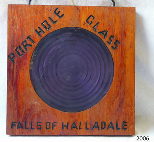
Glass
Falls of Halladale The Falls of Halladale was a four-masted sailing ship built-in 1886 in Glasgow, Scotland, for the long-distance cargo trade and was mostly used for Pacific grain trade. She had a sturdy construction built to carry maximum cargo and able to maintain full sail in heavy gales, one of the last of the ‘windjammers’ that sailed the Trade Route. She was one of the first vessels to include fore and aft lifting bridges, which kept the crew safe and dry in as they moved around the decks in stormy conditions. She was owned by Wright, Breakenridge & Co of Glasgow and was one of several Falls Line ships, all of which were named after waterfalls in Scotland. On 4th August 1908, with new sails, 29 crew, and 2800 tons of cargo, the Falls of Halladale left New York, bound for Melbourne and Sydney via the Cape of Good Hope. The cargo on board was valued at £35,000 and included 56,763 tiles of American slate roofing tiles, 5,673 coils of barbed wire, 600 stoves, 500 sewing machines, 6,500 gallons of oil, 14,400 gallons of benzene, plumbing iron, 117 cases of crockery and glassware and many other manufactured items. The Falls of Halladale had been at sail for 102 days when, at 3 am on the of 14th November 1908, under full sail in calm seas with a six knots breeze behind and misleading fog along the coast, the great vessel rose upon an ocean swell and settled on top of a submerged reef near Peterborough on south-west Victoria’s coast. The ship was jammed on the rocks and began filling with water. The crew launched the two lifeboats and all 29 crew landed safely on the beach over 4 miles away at the Bay of Islands. The postmistress at Peterborough, who kept a watch for vessels in distress, saw the stranding and sent out an alert to the local people. A rescue party went to the aid of the sailors and the Port Campbell rocket crew was dispatched, but the crew had all managed to reach shore safely by the time help arrived. The ship stayed in full sail on the rocky shelf for nearly two months, attracting hundreds of sightseers who watched her slowly disintegrate until the pounding seas and dynamiting by salvagers finally broke her back, and her remains disappeared back into deeper water. The valuable cargo was largely lost, despite two salvage attempts in 1908-09 and 1910. Further salvage operations were made from 1974-1986, during which time 22,000 slate tiles were recovered with the help of 14 oil drums to float them, plus personal artefacts, ship fittings, reams of paper and other items (a list of items held at Flagstaff Hill Maritime Village is included below). The Court of Marine Inquiry in Melbourne ruled that the foundering of the ship was entirely due to Captain David Wood Thomson’s navigational error, not too technical failure of the Clyde-built ship. The shipwreck is a popular site for divers, about 300m offshore and in 3 – 15m of water. Some of the original cargo can be seen at the site, including pieces of roof slate and coils of barbed wire. The Falls of Halladale shipwreck is listed on the Victorian Heritage Register (No. S255). She was one of the last ships to sail the Trade Routes. She is one of the first vessels to have fore and aft lifting bridges. She is an example of the remains of an International Cargo Ship and also represents aspects of Victoria’s shipping industry. The wreck is protected as a Historic Shipwreck under the Commonwealth Historic Shipwrecks Act (1976).Porthole glass secured in wood, with a crack in the glass. Writing on wood "porthole Glass Falls of Halladale."Burnt into the wood are the words "porthole Glass Falls of Halladale."falls of halladale, wright, breakenridge & co of glasgow, californian blue roof slate, warrnambool, shipwrecked-coast, flagstaff-hill, flagstaff-hill-maritime-museum, maritime-museum, shipwreck-coast, flagstaff-hill-maritime-village, shipwrecked-artefact, porthole glass -
 Flagstaff Hill Maritime Museum and Village
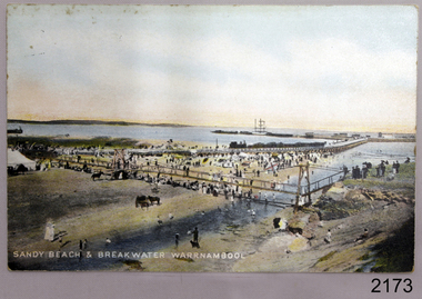
Postcard - Coastal Scene, Joseph Jordan, Sandy beach & breakwater Warrnambool, 1910
The coloured postcard depicts the Port of Warrnambool in the early 1900s. It shows the Breakwater, completed in 1890, the Viaduct, and the Merri River footbridge. There are many people on the sandy river banks, beach and bridge, and some are on the rocks of Middle Island. The printed postcard was made in England and is one of the Jordan Series produced by Joseph Jordan, a renowned photographer in Victoria's Western District.The postcard is locally significant as a record of the early footbridge over the Merri River, and the Viaduct before the space between the pylons was filled it. It shows the use of horses as a means of transportation. The photograph is also associated with Joseph Jordan, a renowned Victoria's Western District photographer.Postcard, coloured, showing the Port of Warrnambool. People are gathered on the sandy beach beside the river and near the river mouth. They are on and below the footbridge, along with several horses. Some are on the rocky Middle Island. There is a white ship in port. There is a jetty on the left, and buildings at the start of the breakwater. An inscription is printed at the bottom of the picture. The picture is one of the Jordan Series. It was printed in England in 1910."SANDY BEACH & BREAKWATER AT WARRNAMBOOL" "JORDAN SERIES" "PRINTED IN ENGLAND" "1910"warrnambool, shipwreck coast, flagstaff hill, flagstaff hill maritime museum, flagstaff hill maritime village, postcard, merri river, footbridge, warrnambool breakwater, breakwater, viaduct, middle island, port of warrnambool, jordan series, printed in england, 1910, joseph jordan, jordan photography -
 Flagstaff Hill Maritime Museum and Village
Document - Navigation Chart, Admiralty Office, Lady Bay and Warrnambool Harbour, 03/04/1871
This Chart titled “Lady Bay and Warrnambool Harbour” was surveyed by Nav. Lieut. H.J. Stanley, of Britain's Royal Navy, in 1870 and printed in April 1871. The chart was made before the Warrnambool Breakwater was built (construction had begun in 1874 and was completed in 1890). The chart includes Directions for entering Lady Bay, Warrnambool Harbour. These are "Vessels entering Warrnambool Harbour must bring the Red Light in sight and steer in with it in line with the upper white Light bearing North, until the Green Light on the Jetty is opened, when steer towards it and anchor. The best anchorage is in 2 ¼ fms [fathoms)] of water, about a cable from ledge off Breakwater rock. Or where convenient, according to draught of water, only endeavouring to anchor as close as possible to Breakwater rock. It is not safe to enter or leave the Harbour in south westerly or Southerly gales.” This chart is significant for its strong connection to the maritime history of Warrnambool Harbour and Lady Bay, and eventually to the Warrnambool Breakwater. The Warrnambool Breakwater is registered as a place of significance on the Victorian Heritage Database (VHR H2024). A copy of the same chart was used to plan several submissions for future changes to the jetty and breakwater. The chart is a historical record of structures existing in 1870; the Warrnambool Jetties, Lady Bay, the leading lights (lighthouses), streets, roads, bridges and many buildings. It also shows the lay of the land and seabed.Canvas chart of Australia, South Coast, Victoria Title: Lady Bay and Warrnambool Harbour Surveyed by Nav. Lieut. H.J. Stanley, R.N., 1870. Magnet Variation, 1870 Published April 3, 1871, by the Admiralty, London. Directions for vessels entering Warrnambool Harbour are printed on the chart. The chart has a lacquer or seal over it.Top of chart has logo "HYDROGRAPHER OFFICE" "Price Eighteen Pence". "Engraved by Edward Weller" Along bottom of Chart: “London… Published at the Admiralty, 3rd April 1871, under the Superintendence of Rear Admiral G.H. Richards, F.R.S. Hydrographer, Corrections July 71” Bottom of chart “Australia South Coast Victoria Lady Bay and Warrnambool Harbour. 2494”flagstaff hill, warrnambool, chart of lady bay warrnambool 1870, warrnambool harbour, cartography, navigation, warrnambool breakwater, 1871, australia – south coast / victoria, lady bay, 1870, nav. lieut. h.j. stanley, r.n, directions for entering warrnambool harbour, hydrographer office, rear admiral g.h. richards, edward weller, port of warrnambool, flagstaff hill maritime museum & village, maritime museum, maritime village, shipwreck coast, map, chart, navigation chart, admiralty chart, breakwater, jetty, pier, vhr h2024 -
 Mission to Seafarers Victoria
Photograph - Photograph, Black and white, Allan Charles Quinn, 30 September 1949
Alan Charles Quinn went to sea at 16 years of age and photographed his work and the places he visited. His collection of photo albums form a pictorial autobiography. The Alan Charles Quinn collection also includes a series of letters written to and from his mother.Black and white photograph of a boats in a harbour in San Francisco. In the background there are hills and the Golden Gate Bridge. The picture shows a large number of small boats and one which is slightly bigger boat. Blue/green ink, handwritten on reverse: "30/9/49 S.F" Handwritten in pencil: "K8/B"san francisco, moorings, boats -
 Phillip Island and District Historical Society Inc.
Financial record, Credit account from J.Kennon & Sons for N. L. Smith, Rhyll, 23 March 1914
... , Richmond and a leather warehouse in Bridge Road. [ Source -Heritage... Street, Richmond and a leather warehouse in Bridge Road. [ Source ...J.Kennon & Sons were known particularly for their use of the chrome tanning process. They were also buyers and exporters of Australian skins and wool.The firm had tanning works,, established in 1863, offices and stores in the vicinity of River Street, Richmond and a leather warehouse in Bridge Road. [ Source -Heritage Victoria https://www.google.com/url?sa=t&rct=j&q=&esrc=s&source=web&cd=&cad=rja&uact=8&ved=2ahUKEwiI7OnmofT_AhUia2wGHXNGCaUQFnoECBQQAQ&url=http%3A%2F%2Fimages.heritage.vic.gov.au%2Fattachment%2F24257&usg=AOvVaw0ER8QGZ-3eW4PAg0VM909h&opi=89978449]HistoricalCream coloured account with details eg product and amount in black ink. Includes a separate piece of paper attached to page, with a recipe for vermin destroyer typed in red ink.Credit account of N. L. Smith, Rhyll, Phillip Island. One bag of Rabbit Weevily. March 23, 1914 J. Kennon & Sons River Street, Richmondn.l.smith rhyll, j.kennon and sons, rabbit poison, account, vermin -
 Phillip Island and District Historical Society Inc.
Photograph, Harry Bradley - Phillip Island Identity
Harry Bradley was a local Identity. Born in Yorkshire, England, 8/4/1916. Joined the Australian Army 19/5/1941 living in Cowes Phillip Island Victoria.Historical491-01: Harry Bradley an Australia Army Portrait - WWII 491-02: Harry Bradley & Ted Walton, very close fishing mates 491-03: Original House of Bradleys, opposite Race Track?? Ford Vehicle. Now Beachcomber Estate 491-04: Harry Bradley working on the 1st Phillip Island Bridge 491-05: Harry Bradley's parents - Father - Edwin and Mother who was killed by a bull 491-06: Harry Bradley - Equal 1st Competition at the Lang Lang Gun Club 491-07: Elsford Guest House - Post Card 491-08: Map of Phillip Island - Post Card Also DVD supplied with 491-01 to 06 on it.As Above with Harry's details listed on 491-01harry bradley, ted walton, edwin bradley, lang lang gun club, elsford guest house, phillip island map