Showing 20102 items matching "were street"
-
 Sunbury Family History and Heritage Society Inc.
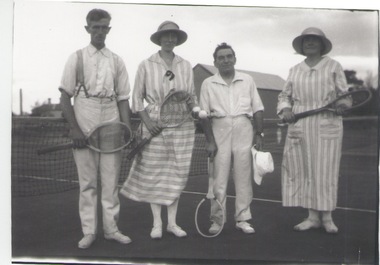
Photograph, c 1920s
... of the courts which were sited in Evans Street, which is now occupied... were sited in Evans Street, which is now occupied ...The four people had gathered to play a tennis match of the courts which were sited in Evans Street, which is now occupied by then Sunbury Shopping Centre adjacent to the railway line.A black and white photograph of two ladies and two men standing in front of a net on a tennis court.tennis, tennis courts -
 Bacchus Marsh & District Historical Society
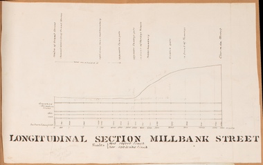
Drawing, Longitudinal Section Millbank Street Bacchus Marsh circa 1905
... 1900s works to improve the drainage of the street were discussed... 1900s works to improve the drainage of the street were discussed ...Millbank Street is a short street located close to the central business and shopping area of Bacchus Marsh. In the early 1900s works to improve the drainage of the street were discussed and planned by Bacchus Marsh Shire Council. This plan is most probably the plan discussed at a Shire Council meeting in April 1905. Single page plan showing a longitudinal section view of MIllbank Street running from Clarinda Street to Grant Street in Bacchus Marsh. The names of Millbank Street property owners, Cain, Shelley, Oliver and Ramsay are marked on this plan. Scale: Vertical 10 feet to 1 inch. Horizontal: 100 links to 1 inch Part of a set of maps which are pasted into a bound volume containing 76 maps or plans in total. High resolution digital image stored on BMDHS computer network. bacchus marsh victoria maps, millbank street bacchus marsh -
 Greensborough Historical Society
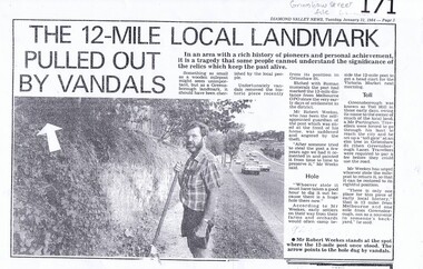
Newspaper clipping, Diamond Valley Leader, The 12-Mile Local Landmark Pulled Out By Vandals, 31/01/1984
... and later theft of a 12 Mile marker from the Grimshaw Street... the Grimshaw Street location were it had stood since the very early ...A newspaper article relating the history, significance and later theft of a 12 Mile marker from the Grimshaw Street location were it had stood since the very early days of settlement of the district. The road marker had been a local landmark. A photocopy of an article fromt the Diamond Valley News.Nilgrimshaw street, melbourne gpo, 12 mile marker, greensborough -
 Galen Catholic College
Galen Catholic College Temporary Home, 1975
... college buildings at College Street were not ready at the start... in 1975 but the new college buildings at College Street were ...Galen Catholic College began operation in 1975 but the new college buildings at College Street were not ready at the start of the school year. College classes were temporarily held at St. Patrick's Hall in the heart of Wangaratta until the building had been completed. These two photos are a vivid record of that time. galen catholic college, galen college, st. patrick's hall, st. patrick's church, temporary campus -
 Greensborough Historical Society
Photograph - Digital image, 49 Grimshaw Steet, 02/05/2013
... These photographs of 49 Grimshaw Street Greensborough were... Street Greensborough were taken in 2013 to show changes over 40 ...These photographs of 49 Grimshaw Street Greensborough were taken in 2013 to show changes over 40 years, based on Ron Reynold’s sketches in the 1973 publication “Greensborough and Greenhills” published by Cypress Books.Digital copy of 2 colour photographs.greensborough and greenhills, grimshaw street greensborough, ron reynolds -
 Kew Historical Society Inc
Plan - Subdivision Plan, J R Mathers & McMillan, Heart of Richmond Estate : Richmond, 1928
... created Hollick, Cole and Kennedy streets were constructed from... created Hollick, Cole and Kennedy streets were constructed from ..."In 1928 the land on the east side of Johnson Street was subdivided in 60 lots for the ‘Heart of Richmond Estate’. The houses in the subdivision, along the east side of Johnson Street, and in the newly created Hollick, Cole and Kennedy streets were constructed from 1928 to 1937." (Source: City of Yarra Heritage Gaps Review One 2013)Portion of subdivision plan pasted on to cardboard. Area includes Johnson Street, Victoria Street, Kennedy Street, Cole Street, Hollick Street, Bennett StreetTitle Certificate Vol.2381, Folio 476130 Phillips, Fox & Masel, 440 Little Collins Street, Melbourne (Local estate agent: Jas. R. Mathers & McMIllan, 136 Cotham Road, Kew)subdivision plans - richmond (vic.), heart of richmond estate -
 Kew Historical Society Inc
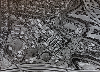
Photograph - Aerial Photograph, Aerial Photograph of Willsmere, circa 1980, c. 1980
... . The doctors residences in Wills street were made of 'Glen Iris... residences in Wills street were made of 'Glen Iris' Olympic Bricks ...This aerial photograph shows the Kew Cottages, and doctors/clergy residences on the north side of Wills Street, before the State Government sold the land for residential development. The doctors residences in Wills street were made of 'Glen Iris' Olympic Bricks. According to neighbours of the time most of the buildings were demolished overnight in the 1980s.Aerial photograph of Willsmere and the Kew Cottages bounded by the Boulevard, the Chandler Highway, Princess Street and Fellows Street. The roundabout at the intersection of Princess Street, Wills Street, and Eglinton Street is at the top left. The Eastern Freeway is at the lower edge of the photograph.kew cottages, eastern freeway, willsmere, yarra river, aerial photographs -- kew (vic), kew boulevard, willsmere mental hospital, kew mental hospital, kew childrens cottages -
 Greensborough Historical Society
Photograph, Grimshaw Street Greensborough, 1976c
... . Greensborough first traffic lights were installed along Grimshaw Street... and Henry Streets, showing Safeway (Woolworths), traffic lights ...South-west corner of Grimshaw and Henry Streets, showing Safeway (Woolworths), traffic lights and BP service station. Greensborough first traffic lights were installed along Grimshaw Street circa 1976.Black and white photograph"Safeway opposite the Greensborough Primary School, traffic lights for school crossing"safeway, grimshaw street greensborough, henry street greensborough -
![Letter - Correspondence - Letter, Bryan Henderson, [Grimshaw Street], 12/11/2022](/media/collectors/4f729f5697f83e03086015b8/items/6602568f792920bfe4defef4/item-media/66067f5c6512b153577249f1/item-fit-380x285.jpg) Greensborough Historical Society
Greensborough Historical SocietyLetter - Correspondence - Letter, Bryan Henderson, [Grimshaw Street], 12/11/2022
... noted was that the streets mentioned were named after founding... to Grimshaw Street. Also noted was that the streets mentioned were ...Letter to Channel 9 regarding origin of Greensborough street names, with particular reference to Grimshaw Street. Also noted was that the streets mentioned were named after founding members of the Greensborough Wesleyan Church in the mid 1800s.Black and white print, colour photograph, with photocopied extract from "Greensborough Uniting Church's first 150 years" grimshaw street, living faith church, grimshaw family -
 Eltham District Historical Society Inc
Photograph, Kenneth Ingram (jnr) and Pam Ingram by the houses at the end of Thomas Street, Eltham, c.1945
... Photo taken at the family home of 19 Thomas Street (since... melbourne Photo taken at the family home of 19 Thomas Street (since ...Photo taken at the family home of 19 Thomas Street (since replaced by a new build). In the background is 22 Thomas Street, the home of Violet Feldbar (nee Teagle), Pam and Ken's aunt, sister to Margaret Rose Ingram. Thmas Street was named after their grandfather, Thomas Teagle and many of the Teagle family homes were in this street.pamela lorraine ingram, pamela thoonen (nee ingram), eltham, house, margaret rose fielding (nee teagle), thomas street, violet feldbauer (nee teagle), kenneth albert ingram, pam thoonen (nee ingram) collection -
 Wodonga & District Historical Society Inc
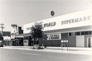
Photograph - Codling Collection 01 - High Street East - Coles Supermarket, 1980s
... was for drivers coming from Stanley Street. Parking meters were... Street. Parking meters were introduced in High Street in 1977 ...Miss Olive Codling was a Foundation Member and a Life Member of the Wodonga Historical Society. Many of her prize-winning photos are held in the Society Collection. She also held a range of roles and committee positions in a wide range of Wodonga community organisations. These included the Horticultural Society, the Wodonga Arts Council, the Wodonga Camera Club and the Wodonga Lapidary Club. This photo collection is significant as it documents how the businesses and buildings in Wodonga have evolved and contributed to community throughout the 20th century.Eastern side of High Street, Wodonga - Coles New World Supermarket opened on Wednesday 18th August 1971. The One Way sign was for drivers coming from Stanley Street. Parking meters were introduced in High Street in 1977 and remained until 1996. Arch Sloman was the first Manager. This location had earlier been occupied by Stiff and Gannon which was demolished to make way for the new supermarket.wodonga businesses, high st wodonga, susan hines, s & e rendich -
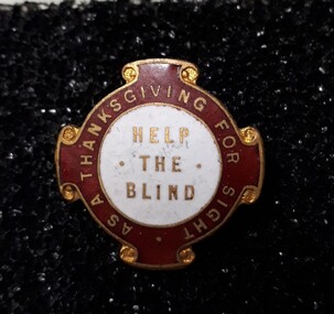 Vision Australia
Badge - Object, Help the Blind badge, 1940-1980
... for the Blind, these badges were sold by street sellers in Melbourne..., these badges were sold by street sellers in Melbourne. "Help the Blind ...To raise funds for the Royal Victorian Institute for the Blind, these badges were sold by street sellers in Melbourne. "Help the Blind" - A red, white and gold badge, circular, with four scroll shapes on the edges. The centre is white, with 'Help the Blind' in gold; the outer area is red with gold edging and words, 'as a thanksgiving for sight'. Some badges have paper numbers on the reverse. Metal pin with red and white enamel, and gold edgingHelp the Blindroyal victorian institute for the blind, badges -
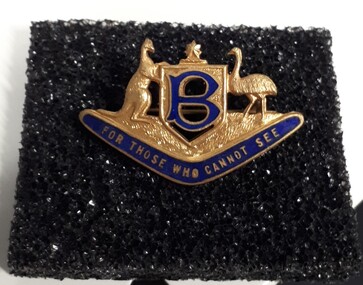 Vision Australia
Badge - Object, For Those Who Cannot See badge, 1940-1980
... for the Blind, these badges were sold by street sellers in Melbourne..., these badges were sold by street sellers in Melbourne. A gold colour ...To raise funds for the Royal Victorian Institute for the Blind, these badges were sold by street sellers in Melbourne. A gold colour Australian coat of arms (Kangaroo and emu beside a shield with a star at the top), sits above a blue enamelled boomerang. In the shield is the letter 'B' in blue enamel. 'For those who cannot see' is written in gold lettering across the boomerang. Metal pin with blue enamel letteringFor those who cannot see royal victorian institute for the blind, badges -
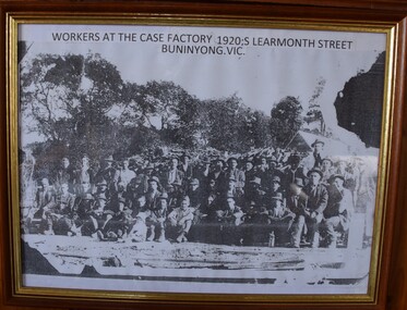 Buninyong Visitor Information Centre
Print - Photograph, Workers at the Case Factory, 1920s Learmonth Street Buninyong, Circa 1900
... at Netherby 606 Warrenheip Street and were involved in the Methodist...) resided at Netherby 606 Warrenheip Street and were involved ...Howards Box factory. The Howard family (owners) resided at Netherby 606 Warrenheip Street and were involved in the Methodist Church, football, bowls and the fire brigade. James Howard owned the factory. he had two sons, Arthur and Charles. Early Buninyong. This is a rare image of early industry. Circa 1900. Framed photocopy of early photograph of workers at the case factory. Approximately 48 employees. Wood pile and trees in background, rail line in foreground.box factory, fruit boxes, factories, industry -
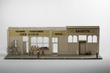 Port Fairy Historical Society Museum and Archives
Mixed media - Model, John Sickler Tailor and Gazette Building, early 1970`s
... were relocated to Gipps Street.... the museum and Archives were relocated to Gipps Street. This model ...This model was part of a panorama of 11 pieces designed from drawings in an 1892 almanac printed by the Port Fairy Gazette. The panorama was used in the Historical rooms in Bank Street on an extended mantle piece before the museum and Archives were relocated to Gipps Street.This model was made as a part of an eleven piece panorama of the streetscape of Port Fairy in 1892. By a local resident.small hand made model of a shop front from the 1892 almanacTailoring Establishment John Sickler Gazette Officemodel, panorama, sackville street, mewkill, almanac, bank street -
 Federation University Historical Collection
Booklet, Ballarat School of Mines, The School of Mines and Industries Ballarat, 1990
... of the Ballarat School of Mines were: Barkly Street (Business and Computer... for the goldfields. In c1990 campuses of the Ballarat School of Mines were ...The Ballarat School of Mines was established in 1870 through initiatives of the Ballarat Mining Board which felt there was a need for such an institution because of the declining number of mine managers for the goldfields. In c1990 campuses of the Ballarat School of Mines were: Barkly Street (Business and Computer Studies, Hairdressing and Horticulture apprenticeships); Agriculture Training Centre at the Ballarat Common, Ring Road; Davey Street (Carpentry and Joinery); Ararat Campus (Business Studies, Electronics, Welding, short courses); Lake Bolac TAFE Centre (Woolclassing, Post-Primary Service Programs); Ararat Prison (Basic Education and Training Programs) Howitt Street (Bricklaying); Ballarat Airport (Motorcycle Rider Training Facility.13 page soft covered promotional book covering the Ballarat School of Mines. The book includes an historical overview, timeline, Inskill, enrolment profile, student support, E.J. T. Tippett Library, Amenities Building, L.F.J. Hillman Recreaton Centre, Hillman, Tippett. There are numerous black and white images.ballarat school of mines, ballarat mining board, peter shiells, shiells, morgan john, john cain, timeline, inskill, small business centre, leoda atkinson, m.b. john -
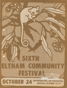 Eltham District Historical Society Inc
Program, Program of Events, Sixth Eltham Community Festival, October 24, 1980 incorporating the Panton Hill Festival, October 18-19, 1980
... , Were Street Theatre, Zettlock..., Were Street Theatre, Zettlock 1980, alan marshall, eltham ...Event program, 81 events, Sat-Sun 18-19 Oct, Wed 22 Oct, Fri 24 Oct-Sun 2 Nov, Tue 4 Nov and Sat 8 Nov and local advertisers Alan Marshall (Pioneers and Painters), Aquapilca, Artist Showcase, Bimbadeen Galley Pty Ltd, Bimbi World, Blondies Fashion Boutique, Briar Hill Timber & Trading, Cheepa Toys, Country Art Store, Debonaire Air Conditioning Pty Ltd, Diamond Valley Drapes, Diamond Valley News, Diamond Valley Photographic Services Pty Ltd, Diamond Valley Windscreens, Don Brown, Eccacentre, Economy Timber & Hardware, Edens Hobbycraft & Art Supplies, Eltham Gallery, Eltham Hardware & Plumbing Supplies Pty Ltd, Eltham Jeanery, Eltham Living and Learning Centre, Eltham Produce Store, Grant Taylor, Grimshaw Motor Cycles, Just Looking Furniture, Kenton Footwear, Lamers Construction Pty Ltd, Leisure Centre, Lovittools, Lower Plenty Sports Centre, Montflora, Montmorency Gospel Chapel, Montmorency Pets, Montsalvat, Para Furnishings, Paul's Sports Store, Pegasus Interiors, Pioneers and Painters, Program, R & S Slocum Floorcovering Pty Ltd, R. & S. Trading, R.F. & D.M. Kidd, Sa Boutique, Skybeam Antennas, Studio Papilio, Style Interiors, The Living Water Bookshop, Todaro Coiffure, Valley Tiffany Lighting, W. Hutchison, Were Street Theatre, Zettlock16 pages, stapled, coloured1980, alan marshall, eltham festival, mal harrop, pioneers and painters -
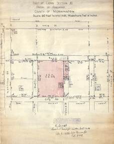 Ringwood and District Historical Society
Document, 1926 Land Survey drawing of the area surrounding 1-5 City Road, Ringwood
... exist, these were Duffy Street (to the west), Evans Street (east... were defined but no longer exist, these were Duffy Street ...Drawing on parchmentHand-drawn survey of what is now 1-5 City Road, Ringwood. Drawn by K Arndt, licensed surveyor, 237 Queen Street, Melbourne Tel 5118 on 25 September 1926. The block of land in question was 2 roods, 21 and 8/10 perches in size. The location was between Haig Street in the north, City Road in the south, Wantirna Road in the west and Victoria Road in the east. The Good Shepherd Retirement Village (Lutheran) now occupies the land. The drawing shows a number of existing weatherboard houses, fences and frontage sizes. A number of named roads were defined but no longer exist, these were Duffy Street (to the west), Evans Street (east) and Victoria Street (further east). Ireland Street still exists in the south. -
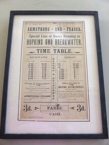 Warrnambool and District Historical Society Inc.
Poster - Armstrong and Fraser timetable, Late 19th Century
... by Armstrong and Fraser.Their stables were in Liebig Street... and Fraser.Their stables were in Liebig Street, Warrnambool next ...This poster is a time table for the coaches operated by Armstrong and Fraser.Their stables were in Liebig Street, Warrnambool next to the Commercial Hotel (The Whalers Hotel today) Armstrong and Fraser commenced business in 1882 and were prominent in Warrnambool at the end of the 19th century and the beginning of the 20th century. The kept as many as 70 horses in their stables and operated a daily timetable for tourists especially those going to the mouth of the Hopkins River and to the breakwater. This poster is of considerable interest as the time table indicates the extensive business of an early coach service in Warrnambool over 100 years ago. The poster comes possibly from the old Warrnambool Museum.This is a sheet of paper containing black printing and handwriting in black ink. It is encased in a black wooden frame with a white cardboard surround and a black border. It has glass protection. There is string and wire at the back for hanging the item . ARMSTRONG* AND * FRASER Special line of buses Running to HOPKINS AND BREAKWATER TIME TABLE (Also other detail re fares, Proudfoot's boating establishment and horses and conveyances) ( Handwriting 87,90, 91 January to March July to Sept. April to June Jany to March) warrnambool, bus timetable, armstrong and fraser -
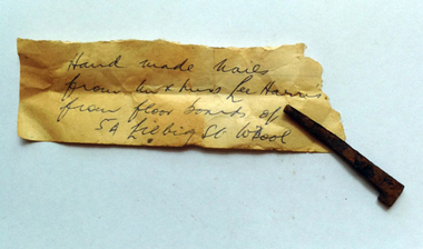 Warrnambool and District Historical Society Inc.
Functional object - Nails Hand made from Liebig St, 19th Century
... the corner of Liebig and Merri Streets, were erected in 1860... These nails were found in the floorboards at 5A Liebig Street ...These nails were found in the floorboards at 5A Liebig Street, the residence of Lee Harris at the time. The nails, being of the 19th century variety, pre-date the present building and must have come from a previous dwelling or perhaps a building associated with the old Shire Offices. The Shire Offices, near the corner of Liebig and Merri Streets, were erected in 1860 and the Shire continued to operate from there until 1936. These nails are of interest as an example of the type of nails used in buildings in Warrnambool in the 19th century. These are 13 iron nails which taper to a point and have a blunt half head. They are all in a rusty condition. nails, 5a liebig street, shire offices, warrnambool -
 City of Kingston
Photograph - Black and white, c. 1958
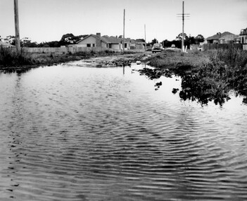
... streets were unsealed and without footpaths and some were dirt... streets were unsealed and without footpaths and some were dirt ...This photograph depicts flooding of Ozone Avenue in Beaumaris, located off Balcombe Road. Roads in the Beaumaris area lacked sufficient drains to clear surface water. In many cases streets were unsealed and without footpaths and some were dirt tracks. Gutters and road surfaces were made of clay and in the wetter months of winter, unsealed roads and tracks became impossible quagmires that were unnavigable for vehicles and pedestrians. In the first decade after World War II there was rapid expansion in construction of new houses in the suburb of Beaumaris. Utilities and infrastructure to support the growth of housing was inadequate and not provided for prior to the development of the area. Without rudimentary drainage, flooding was frequent. Storm water runoff, domestic sullage and septic tank overflow would form large pools and families were sometimes marooned within their homes. The frequent flooding caused isolation and hardship and residents endured difficulties with accessibility to facilities. These disadvantages had the potential to cause social issues for the new residents.Black and white photograph of flooding in Ozone Avenue, Beaumaris. The image shows floodwaters with boggy and rough terrain on an unsealed road with housing in the distance.Handwritten in blue ink: 2124 circled Handwritten in red ink: 80% Handwritten in blue ink on yellow Post-It note: Chap 6. underlined, 2194 Ozone Ave Beaumaris 1958beaumaris, ozone avenue, balcombe road, flooding, roads, infrastructure -
 Vision Australia
Badge - Object, Remember the Blind badge, 1940-1980
... for the Blind, these badges were sold by street sellers in Melbourne..., these badges were sold by street sellers in Melbourne. "Remember ...To raise funds for the Royal Victorian Institute for the Blind, these badges were sold by street sellers in Melbourne. "Remember the Blind" - Blue and white oval badges with the words, 'Remember the Blind' around the edge. The outer oval is narrow, white with gold edges and words. A dark blue oval is in the centre, suspended over the empty space by four curved pieces of metal, with gold edging. Some badges have paper numbers on the reverse. Metal pin with enamel with writingRemember the Blind royal victorian institute for the blind, badges -
![Photograph - Digital image, Rand Street Bridge [Greensborough], 02/05/2013](/media/collectors/4f729f5697f83e03086015b8/items/572af0f12162f118342f250e/item-media/572af1252162f118342f2a1f/item-fit-380x285.jpg) Greensborough Historical Society
Greensborough Historical SocietyPhotograph - Digital image, Rand Street Bridge [Greensborough], 02/05/2013
... These photographs of the Rand Street Bridge were taken... Street Bridge were taken in 2013 to show changes over 40 years ...These photographs of the Rand Street Bridge were taken in 2013 to show changes over 40 years, based on Ron Reynold’s sketches in the 1973 publication “Greensborough and Greenhills” published by Cypress Books. This is a pedestrian swing bridge over the Plenty River between Rand Street and Greensborough Station.Digital copy of colour photograph.greensborough and greenhills, rand street bridge, rand street greensborough, ron reynolds -
 Kew Historical Society Inc
Plan - Subdivision Plan, Jas R Mathers Son & McMillan, East Kew Tramway Estate, 1915
... , and Campbell, Hunter and Wishart Streets. [Hunter and Wishart Streets..., and Campbell, Hunter and Wishart Streets. [Hunter and Wishart Streets ...Pru Sanderson, in her groundbreaking ‘City of Kew Urban Conservation Study : Volume 2 - Development History’ (1988), summarised the periods of urban development and subdivisions of land in Kew. The periods that she identified included 1845-1880, 1880-1893, 1893-1921, 1921-1933, 1933-1943, and Post-War Development. These periods were selected as they represented periods of rapid growth or decline in urban development. An obvious starting point for Sanderson’s groupings involved population growth and the associated economic cycles. These cycles also highlighted urban expansion onto land that was predominantly rural, although in other cases it represented the decline and breakup of large estates. A number of the plans in the Kew Historical Society’s collection can also be found in other collections, such as those of the State Library of Victoria and the Boroondara Library Service. A number are however unique to the collection.The Kew Historical Society collection includes almost 100 subdivision plans pertaining to suburbs of the City of Melbourne. Most of these are of Kew, Kew East or Studley Park, although a smaller number are plans of Camberwell, Deepdene, Balwyn and Hawthorn. It is believed that the majority of the plans were gifted to the Society by persons connected with the real estate firm - J. R. Mathers and McMillan, 136 Cotham Road, Kew. The Plans in the collection are rarely in pristine form, being working plans on which the agent would write notes and record lots sold and the prices of these. The subdivision plans are historically significant examples of the growth of urban Melbourne from the beginning of the 20th Century up until the 1980s. A number of the plans are double-sided and often include a photograph on the reverse. A number of the latter are by noted photographers such as J.E. Barnes.The East Kew Tramway Estate was a subdivision of two separate parcels of land between Adeney Avenue and Normanby Road. The larger section included 54 lots facing Adeney Avenue, Argyle Road, and Campbell, Hunter and Wishart Streets. [Hunter and Wishart Streets were created as part of the subdivision.] A further 17 allotments faced Normanby Road, Hubert and Campbell Streets. [The name of Hubert Street was later to be changed to Cecil Street.] The promotion of the sale referred to the advantages of living between two tram routes, in High Street and Cotham Road. On the plan, quaintly drawn trams mark these routes. Also on the plan is the route of part of the Outer Circle [Railway] Line.east kew tramway estate, subdivision plans - east kew -
 Uniting Church Archives - Synod of Victoria
Photograph - Newspaper cutting, 2 March 1984
... The Gipps Street Wesleyan Methodist Church of 1874... operated by the Collingwood Mission. They were: Sackville Street ...The Gipps Street Wesleyan Methodist Church of 1874 and the adjoining school hall, were built in the Collingwood Flat area - one of the municipality's poorest areas. In 1903, the Collingwood Methodist Mission was established with its headquarters in the Gipps Street Church. Six Methodist Missions were created in inner Melbourne. Three churches were operated by the Collingwood Mission. They were: Sackville Street Collingwood, Elizabeth Street, North Richmond (demolished), and Gipps Street Collingwood (demolished). The Mission operated until approximately 1930. The Wesleyan Church and School in Sackville St. Collingwood was built in 1886 and used as a church for 65 years. It was also part of the Collingwood Methodist Mission before being converted to an industrial/commercial complex. The church was auctioned on 3 March 1984.The cutting gives information about the history of the Church at 25 Sackville St. Collingwood prior to its auction sale on 3 March 1984gipps st. methodist church, les gorrie, collingwood mission, sackville street church, wesleyan -
 Uniting Church Archives - Synod of Victoria
Photograph, undated
... The Gipps Street Wesleyan Methodist Church of 1874... operated by the Collingwood Mission. They were: Sackville Street ...The Gipps Street Wesleyan Methodist Church of 1874 and the adjoining school hall, were built in the Collingwood Flat area - one of the municipality's poorest areas. In 1903, the Collingwood Methodist Mission was established with its headquarters in the Gipps Street Church. Six Methodist Missions were created in inner Melbourne. Three churches were operated by the Collingwood Mission. They were: Sackville Street Collingwood, Elizabeth Street, North Richmond (demolished), and Gipps Street Collingwood (demolished). The Mission operated until approximately 1930. The Wesleyan Church and School in Sackville St. Collingwood was built in 1886 and used as a church for 65 years. It was also part of the Collingwood Methodist Mission before being converted to an industrial/commercial complex. The church was auctioned on 3 March 1984.B & W exterior view of the Sackville St. Collingwood Methodist Mission. gipps st. methodist church, les gorrie, collingwood mission, sackville street church, wesleyan -
 Stawell Historical Society Inc
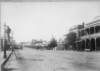
Photograph, Main Street Stawell from front of Town Hall looking East with Mr Richard Miller lighting the gas light on left of photo
... 1901 Acetylene Gas lamps were installed in Main Street... 1901 Acetylene Gas lamps were installed in Main Street. Benzene ...Main Street from front of Town Hall looking East. Mr Richard Miller on ladder to the gas light on left of photo. After 1901 Acetylene Gas lamps were installed in Main Street. Benzene lamps were used for some years. A lamplighter was employed from 1913.B/W Photo With Mr Richard Miller lighting the light on the left and the Town Hall on the Rightstawell streetscape -
 Port Fairy Historical Society Museum and Archives
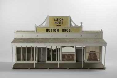
Mixed media - Model, Albion House, early 1970`s
... and Archives were relocated to Gipps Street Port Fairy... Street Port Fairy great-ocean-road This model was part ...This model was part of a panorama of 11 pieces designed from drawings in an 1892 almanac Printed by Port Fairy Gazette. The panorama was used in the History Society rooms in Bank St Port Fairy on an extended mantel piece, before the Museum and Archives were relocated to Gipps Street Port FairyThis model was made as a part of an eleven piece panorama of the streetscape of Port Fairy in 1892. By a local resident of the town.Small hand made 3D model of a shop front from the 1892 AlmanacAlbion House 1854 Hutton Bros.sackville street, model, mewkill, almanac, albion house, bank street -
 Wodonga & District Historical Society Inc
Map - Boorgunyah - "The Town that never was"
... and laid out, and streets were named. This town was to house..., and streets were named. This town was to house the workers ...At the height of the river trade, there was a town surveyed and laid out, and streets were named. This town was to house the workers at the river port of Red Bank when the paddle steamers plied the Murray River as far as Albury, carrying produce such as wool and wheat to the various towns along the river in the 1800s. As the river trade died away, this town never went ahead – one might say, “The town that never was.” A lone gum tree stands on the site today.This item is significant because it documents plans which were made for the early development of Wodonga.A black an white map depicting the proposed location of the township. The map is based on a sketch and is not to scale,early wodonga, boorgunyah - "the town that never was", wodonga heritage -
 Kew Historical Society Inc
Plan, Melbourne & Metropolitan Board of Works : Borough of Kew : Detail Plan No.1565, 1905
... cases renamed. The plan shows those streets that were bordered... that were bordered by Ross Street, Mount Street, Sackville Street ...The Melbourne and Metropolitan Board of Works (MMBW) plans were produced from the 1890s to the 1950s. They were crucial to the design and development of Melbourne's sewerage and drainage system. The plans, at a scale of 40 feet to 1 inch (1:480), provide a detailed historical record of Melbourne streetscapes and environmental features. Each plan covers one or two street blocks (roughly six streets), showing details of buildings, including garden layouts and ownership boundaries, and features such as laneways, drains, bridges, parks, municipal boundaries and other prominent landmarks as they existed at the time each plan was produced. (Source: State Library of Victoria). This plan forms part of a large group of MMBW plans and maps that was donated to the Society by the Mr Poulter, City Engineer of the City of Kew in 1989. Within this collection, thirty-five hand-coloured plans, backed with linen, are of statewide significance as they include annotations that provide details of construction materials used in buildings in the first decade of the 20th century as well as additional information about land ownership and usage. The copies in the Public Record Office Victoria and the State Library of Victoria are monochrome versions which do not denote building materials so that the maps in this collection are invaluable and unique tools for researchers and heritage consultants. A number of the plans are not held in the collection of the State Library of Victoria so they have the additional attribute of rarity.Original survey plan, issued by the MMBW to a contractor with responsibility for constructing sewers in the area identified on the plan within the Borough of Kew. The plan was at some stage hand-coloured, possibly by the contractor, but more likely by officers working in the Engineering Department of the Borough and later Town, then City of Kew. The hand-coloured sections of buildings on the plan were used to denote masonry or brick constructions (pink), weatherboard constructions (yellow), and public buildings (grey). MMBW Plan No.1565 is an example of a plan where a number of streets have been created since the area was surveyed, or in other cases renamed. The plan shows those streets that were bordered by Ross Street, Mount Street, Sackville Street and Burke Road. Since 1905, Mawson Street has been created and Mont Albert Road renamed as Dean Street. Named houses on the plan include ‘Tyrol’, ‘Glengorse’, ‘Theodore Villa’, ‘Arncliffe’, ‘Ballynira’ and ‘Hazeldene’. The plan also shows a Wesleyan Church in Sackville Street. In 1883, the Church’s Sunday School celebrated its silver anniversary.melbourne and metropolitan board of works, detail plans, mmbw 1565, cartography