Showing 1910 items
matching town and country
-
 Rutherglen Historical Society
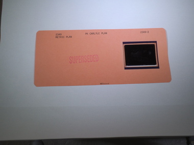
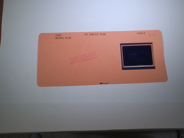
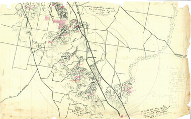
Aperture Card microfilm, Victorian Land Tiltes Office, Parish Plan Carlyle (Superseded)
Town layout of Carlylecard with a single microfilm insertplan, town, boundries, lots, roads -
 Rutherglen Historical Society
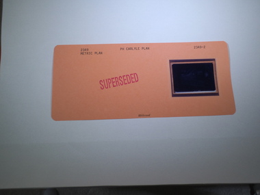
Aperture Card microfilm, Victorian Land Tiltes Office, Parish Plan Carlyle (Superseded)
Town layout of Carlylecard with a single microfilm insertplan, town, boundries, lots, roads -
 Rutherglen Historical Society
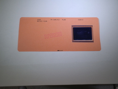
Aperture Card microfilm, Victorian Land Tiltes Office, Parish Plan Carlyle (Superseded)
Town layout of Carlylecard with a single microfilm insertplan, town, boundries, lots, roads -
 Rutherglen Historical Society
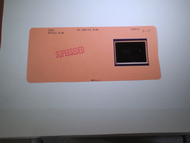
Aperture Card microfilm, Victorian Land Tiltes Office, Parish Plan Carlyle (Superseded)
Town layout of Carlylecard with a single microfilm insertplan, town, boundries, lots, roads -
 Rutherglen Historical Society
Aperture Card microfilm, Victorian Land Tiltes Office, Parish Plan Carlyle (Superseded)
Town layout of Carlylecard with a single microfilm insertplan, town, boundries, lots, roads -
 Rutherglen Historical Society
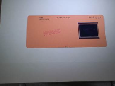
Aperture Card microfilm, Victorian Land Tiltes Office, Parish Plan Carlyle (Superseded)
Town layout of Carlylecard with a single microfilm insertplan, town, boundries, lots, roads -
 Rutherglen Historical Society
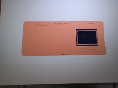
Aperture Card microfilm, Victorian Land Tiltes Office, Parish Plan Carlyle (Superseded), 11/07/2000
Town layout of Carlylecard with a single microfilm insertplan, town, boundries, lots, roads -
 Ballarat Heritage Services
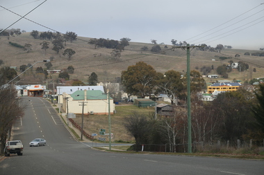
Photograph - Colour, Lisa Gervasoni, Omeo, 2017, 2017
Colour photograph of the Victorian town of Omeo.2017, great alpine road, omeo high plains, omeo, high country, streetscape -
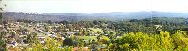 Ballarat Heritage Services
Photograph - Photograph - Colour, L.J. Gervasoni, Daylesford, 1987, c1987
Daylesford is a Central Victorian town.Three colour photographs placed together to make a panoramic view of Daylesford, Victoriadaylesford, spa country, panorama -
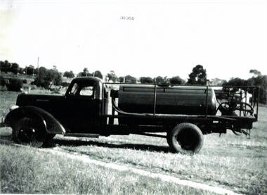 Hume City Civic Collection
Photograph, Water carrier
The Dodge water truck was used in the past by the Sunbury Country Fire members. Country Fire Authority is a volunteer fire fighting organisation attached to many rural towns throughout Victoria and in an important organisation for the state.A black and white scanned photograph with a white border of a fire fighter's water truck. It is parked in a cleared area with a line of trees in the background.water truck, dodge truck, country fire authority -
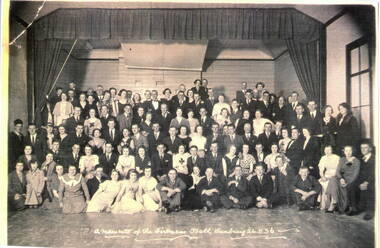 Hume City Civic Collection
Photograph, Fireman's Ball, 26th August 1936
The people were attending the annual Fireman's Ball which was one of the popular events held in Sunbury. Dances and formal balls and other community social events were popular in many towns throughout the country.A black and white photograph of a group of people in fancy dress assembled in a large hall. fireman's ball, sunbury, memorial hall -
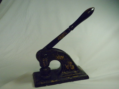 Numurkah & District Historical Society
Functional object - Numurkah Shire Common Seal
THE CONSTITUTION OF MUNICIPALITIES GENERALLY. DIVISION 1. INCORPORATION AND GOVERNMENT OF MUNICIPALITIES AND BOUNDARIES OF DISTRICTS. 8. (1) The inhabitants of every shire borough town and city inhabitants of for the time being subject to the provisions of this Act shall, under corporation. the name of the president councillors and ratepayers of such shire N°-5203 «• '• the mayor councillors and burgesses of such borough the mayor councillors and burgesses of such town or the mayor councillors and citizens of such city as the case may be, be a body corporate with perpetual succession and a common seal with power to break alter and change the same from time to time with the approval of the Governor in Council and shall by such name be capable in law of suing and being sued, of purchasing holding and alienating land, and of doing and suffering subject to the provisions of this Act all such other acts and things as bodies corporate may by law do and suffer. (2) The corporation of ******** Shire Common Seal 54. The common seal of the municipality shall be kept in a box having two locks, of one of which locks the chairman of the municipality shall have a key and of the other of which locks the key shall be kept by the municipal clerk; and the corporate seal shall not be affixed to any document unless the chairman of the municipality and one other member of the council or in the absence of such chairman unless two councillors be present. 91. The Council’s Common Seal (1) The Chief Executive Officer must ensure the security of the Council's common seal at all times. (2) The Council's common seal may only be used on the authority of the Council given either generally or specifically and every document to which the seal is affixed must be signed by the Chief Executive Officer or a senior officer authorised by him or her. (3) Any person who uses the Council's common seal without authority is guilty of an offence. (4) Any person who uses any replica of the council’s seal without authority is guilty of an offence. The Numurkah Shire was amalgamated into the Moira Shire and the seal now redundant. This is the only Numurkah Shire Common Seal in existence.local government, common seal, numurkah -
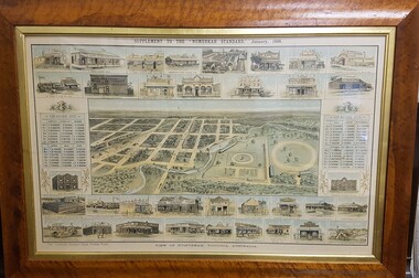 Numurkah & District Historical Society
Map - Print in frame - Numurkah Township 1888, Supplement to the "Numurkah Standard" January 1888 View of Numurkah Victoria Australia
The late Hilda Morieson (very active in early Historical Society) owned the print. It was then passed on to Mary Morieson, then to Rosemary Kennet. It has been passed onto the Historical Society with permission from Ben Morieson, Hilda's grandsonLarge coloured print of supplement to Numurkah Standard 1888. Artist's view/impression of Numurkah streets (map) surrounded by artwork of a number of Numurkah businesses in the town and local district. The print is under glass in a faux-wood-grained framesee photo abovenumurkah standard, numurkah township map, numurkah businesses, 1888, print -
 Wangaratta High School
WHS Speech Night Pamphlet, 1963
Cream slip of paper outlining the program details for the 1963 Wangaratta High School Annual Speech NightWANGARATTA HIGH SCHOOL PROGRAMME ANNUAL SPEECH NIGHT Thursday, December 12th, 1963 7:45pm Wangaratta Town Hall -
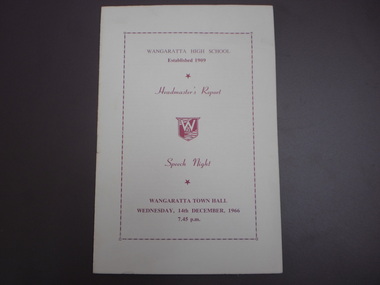 Wangaratta High School
WHS Speech Night Pamphlet, 1966
Cream slip of paper outlining the program details for the 1966 Wangaratta High School Annual Speech NightWANGARATTA HIGH SCHOOL established 1909 Headmaster's Report Speech Night WANGARATTA TOWN HALL WEDNESDAY, 14th DECEMBER, 1966 7:45pm -
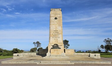 Bayside Gallery - Bayside City Council Art & Heritage Collection
Monument - Memorial, Irwin and Stevenson, Brighton War Memorial, 1927
On 23 July 1922, Brighton City Council adopted the recommendation from a sub-committee that the site for a war memorial be at Green Point, Brighton Beach. Brighton Council invited designs, limited to returned soldier architects and 18 designs were received. The first prize of £30 was awarded to the architecture firm Irwin and Stevenson and the designs were exhibited at the Brighton Town Hall in 1925. The bronze casting, using lost wax technique, was executed by sculptor Mr. Paul Montford, to the design of the architect and the central assemblage was believed to be the largest bronze casting in relief carried out in Australia at the time. The Brighton War Memorial was unveiled by His Excellency the Governor, the Right Honourable Arthur Herbert Tennyson Baron Somers, K.C.M.G., D.S.O., M.C., on Sunday 24th April 1927 in the presence of 4,000 people. The memorial was originally constructed to commemorate those from the City of Brighton who served in World War One but has since been augmented to commemorate those from the municipality of Bayside who have made the ultimate sacrifice during official periods of hostility.War memorial consisting of a sandstone cenotaph, granite base and sandstone terrace situated at Green Point, Brighton. The cenotaph is a truncated obelisk with classical decoration in stone and bronze. The cenotaph bears the Rising Sun badge in bronze relief near its top with bronze lettering running down the cenotaph reading "ERECTED IN HONOUR OF THOSE WHO FOUGHT IN THE GREAT WAR 1914 – 1919". A bronze relief assemblage of crossed weapons, a wreath, the lamp of valour and the Latin phrase "DUCIT AMOR PATRIA" (love of country leads me) sit above the base which is carved with the word "SERVICE". The terrace walls have bronze relief medallions with images of the head of an airman on the left and an infantryman on the right. The back of the cenotaph bears a torch in bronze relief near its top. On the sandstone wall behind the cenotaph are three large bronze plaques that lists the names of those from the City of Bayside who have served in the various conflicts in which Australia has been involved. At the back of the sandstone wall is carved lettering reading "HISTORY GAVE THEM A COMMON FAME. POSTERITY A COMMON MONUMENT" with 1914 carved on the left and 1919 on the right.brighton war memorial, memorial, cenotaph, green point, war memorial, brighton, service, paul montford, irwin and stevenson, rising sun, wreath, weapons, lamp of valour, great war, world war one, honour roll, honour board, roll of honour, ducit amor patriae, brighton beach, city of brighton, leighton major francis irwin, roy kenneth stevenson -
 Buninyong & District Historical Society
Photograph - Original B/W Photograph, Clive Brooks, Buninyong roundabout, cnr Warrenheip and Learmonth Sts, with streetscape of shops on north-east corner, Sept 1993
Roundabout is situated at the centre of the town. Shops in streetscape are a mixture of 1800s and 1900s construction.The streetscape is of historic and social significance, representative of a small country town.Original B/W photograph of roundabout at the corner of Learmonth and Warrenheip Sts, Buninyong. Streetscape of shops on the NE corner. buninyong, roundabout, warrenheip st, learmonth st, streetscape, shops -
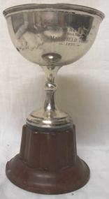 8th/13th Victorian Mounted Rifles Regimental Collection
Decorative object - trophy, 1938 circa
The 20th Light Horse (Victorian Mounted Rifles) was raised in 1920 as part of the 3rd Cavalry Brigade, 2nd Cavalry Division, Citizen Military Forces, with Headquarters at Seymour and depots along the Goulburn Valley from Mansfield to Tocumwal in southern NSW. The regiment was still horse mounted in 1937 when this trophy was awarded to the Mansfield Troop. Fine example of a trophy awarded to a Citizen Military Forces sub-unit drawn from a country town in northeast Victoria prior to WWII. Silver cup with no handles and bakelite base being a trophy for snap shooting in 20th Light Horse Regiment.20th Light Horse Regiment Shoot / Snap Shooting / won by / Mansfield Troop / 1937mansfield, shooting, light horse, 20th -
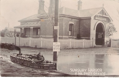 Sunbury Family History and Heritage Society Inc.
Photograph, Sunbury Post Office
The Sunbury Post Office with a residence pictured in the image was the first official post office building in the town. It opened on the corner of Brook and Evans Streets in 1892. Prior to that time postal services were conducted in an office at Sunbury Railway Station. Although the present day post office is still on the Brook-Evans Streets corner, the building has undergone many changes in services and appearances over the years. Like many country towns, the post office offered many services to the residents over the years. short message has been written on the back to a person in Stirling WA.sunbury post office, sunbury railway station, brook street, evans street, post offices -
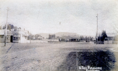 Sunbury Family History and Heritage Society Inc.
Photograph
The post card is an early view of the intersection of Brook and Evans Street looking west and towards Sunbury Station. Mount Holden is in the distance. Chris Christianson's shop is on the LHS of the picture with the post office on the RHS. This image is an early view of Sunbury town centre with the railway station and post office. Like many country towns of this era, The roads have been formed but not surfaced. A sepia photograph in post card format of a view of a town centre showing an intersection and some small buildings with a hill in the distance.TO THE RAILWAY/SUNBURYbrook street, evans street, sunbury railway station, christianson, chris. -
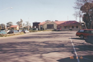 Sunbury Family History and Heritage Society Inc.
Photograph, 25th August 1995
This view of Sunbury Railway Station was taken from the corner of Brook and Evans Streets two years after the station underwent refurbishment and extensions and a carpark was constructed adjacent to the station. The Sunbury & District Heritage Association Inc. has a photograph P0663 of the station taken a century ago from the same place, when Sunbury was a small country town. The contrast between the two images is interesting. A coloured photograph of a streetscape with a weatherboard building in the middle distance,sunbury railway station, brook street -
![Hand-Drawn Map Centred on Myrtleford by Frank Lebbell Frost [ca 1915-1918]](/media/collectors/51d110e42162ef12e06aa06b/items/51fb0bb72162ef156c79aeee/item-media/52a11c442162ef1f0c9c052b/item-fit-380x285.jpg) Beechworth Honey Archive
Beechworth Honey ArchiveHand-Drawn Map Centred on Myrtleford by Frank Lebbell Frost [ca 1915-1918]
This is one of the maps drawn by Frank L. Frost while he was beekeeping in North-East Victoria. This particular map may be reference in the "Wooden" Diary on page 8.Hand-drawn map centred on Myrtleford, Palmerston, Gapstead Road, the Ovens River and the Myrtleford-Wangaratta Road. Shows locations of flowering eucalypts. Scale is 1 mile to 1 inch. Drawn with black pen and grey lead on paper. Names of towns are marked in red pen. hand drawn, hand-drawn, map, myrtleford, palmerston, gapstead, ovens, beekeeping, frost, beechworth honey -
 Beechworth Honey Archive
Hand-Drawn Map Centred on Worouly by Frank Lebbell Frost December 1916
This is one of the maps drawn by Frank L. Frost while he was beekeeping in North-East Victoria. This particular map may be reference in the "Wooden" Diary on page 10.Hand-drawn map centred on Whorouly and showing other towns, including Oxley, Byrne, Edi and Whitfield. Details the local flowering eucalypts. Scale is each red square equals three miles. Drawn with black pen and grey lead on paper. Grid and other features are marked in red.hand drawn, hand-drawn, map, oxley, byrne, whitfield, edi, frost, beekeeping, beechworth honey -
 Beechworth Honey Archive
Hand-Drawn Map Centred on Armstrong by Frank Lebbell Frost Dec 1916
This is one of the maps drawn by Frank L. Frost while he was beekeeping in North-East Victoria. This particular map may be reference in the "Wooden" Diary on page 11.Hand-drawn map centred on Armstrong, a town 6 miles from Ararat. Details vegetation along Great Western Highway. Drawn with black pen and grey lead on paper. Features are marked in red.hand drawn, hand-drawn, map, armstrong, ararat, frost, beekeeper, beechworth honey -
 Beechworth Honey Archive
Map- Eldorado
Compiled from 1971 aerial photography. Printed in 1978.Map shows Eldorado town, Reedy Creek, abandoned gold dredge and Monument Hill. Scale 1:25,000. Printed colour on paper.Map labelled Eldorado. No. 8225-3-4map, eldorado, reedy creek, dredge, monument hill, aerial photography, paper, beechworth honey -
Beechworth Honey Archive
Map- Beechworth
(3x) Map centred on Everton, Beechworth and Eldorado. Map shows Ovens River, Wangaratta- Beechworth Rd., Chiltern- Beechworth Rd., and Ovens Highway. Scale 1:50,000. Back of map white, front is yellow.Albury series R.652 (Beechworth) Two copies have towns shaded red. One copy has locations of dams marked. ca 1974-1975.map, beechworth, everton, eldorado, paper, beechworth honey -
Surrey Hills Historical Society Collection
Work on paper - Ephemera: Theatre program - Miss Hook of Holland, 24 & 26 June 1933, H Bowley, Printer, 192 Canterbury Road, Canterbury, June 1933
"Miss Hook of Holland" is a musical comedy (described as a "Dutch Musical Incident") in two acts, with music and lyrics by Paul Rubens and book by Austen Hurgon and Rubens. It opened at the Prince of Wales Theatre, London, on 31 January 1907, and had a successful run of 462 performances. A synopsis of the plot can be found at https://www.guidetomusicaltheatre.com/shows_m/miss_hook_holland.htm This was one of a number of productions of the Surrey Hills Amateur Operatic Society during the 1930s. The society formed in 1931 and its first production was "The Cingalee", followed in 1932 by "The Arcadians". Other productions were "Princess Ju-Ju", "The Quaker Girl", "The Hook of Holland" and "The Country Girl". Apart its cultural and social importance, the aim of the Society was to raise funds for charity. Mrs Constance Clucas was a driving force behind the productions. A comprehensive account of the society's activities is found in 'A history of Surrey Hills' Sporting clubs and Cultural Groups" by Ken James. This and other programs of the Surrey Hills Amateur Operatic Society provide insight into the cultural life of Surrey Hills in the 1930s.Cream-coloured stapled program printed in brown of a musical comedy in 2 acts. Includes a cast list and committee of the Surrey Hills Amateur Operatic Society, a synopsis of the play, a list of the musical items, photos of Mrs P D Clucas and Mr Norman Lee and a number of ads for local and city businesses."J Hall" signed on back in ink or biro; Norman Lee has signed his photo in ink.camberwell town hall, operetta, miss hook of holland, tanner and monckton, surrey hills amateur operatic society, j c williamson ltd, surrey hills baby health centre, alfred hospital, orthopaedic hospital, surrey hills orchestra, anne's pantry, surrey hall, entertainment, fundraising, musical events and activities, miss cook, mr j colquhoun, h e witchell, a h chenu, norman lee, jean gordon, wilfred darby, jeanette mcdowell, ronald isherwood, howard p denny, miss phyllis heitsch, una v blaikie, howard burnett, jack chapman, winifred broderick, gladys marshall, scyla cocking, harold g brett, harry cocking, aubrey pearce, william morrison, muriel middleton, barbara brigdon, jessie collins, ethel cerini, isabel callaghan, florrie doreian, violet ebbels, jessie fethers, margot gordon, jean robinson, gordon lavender, marjory gordon, grace linford, mollie middleton, eileen middleton, muriel marshall, gladys oliver, mary scragg, beryl scragg, nina sinclair, jean wearne, gladys roberts, rose pearse, jean douglass, jessie powys, mabel thomas, violet abery, roy brian, herbert darby, wilfred harley, robert rowse, jack walker, fred williams, george duncan, mrs g d clucas, mrs p d blaikie, miss w h duncan, mrs g d grover, mrs b collins, miss m harley, mr r cocking, mr h colton, ada walton, mrs c colquoun -
 Brighton Historical Society
Doll, Bead doll, c.1937
Made by the cousin of Brighton local Olga Black. The cousin gave her the doll in 1937, when Olga was around seven years old. Olga Maria Black was born in Melbourne in 1930, the daughter of Ithacan migrants Constantine and Toula Mavrokefalos. Constantine first emigrated to Australia in 1902, returning to Greece circa 1912-13 to serve his home country in the Balkan Wars. Toula's family had left Ithaca for Romania when she was only six months old, but she happened to be visiting the island at the very time that Constantine arrived, fresh from the war. Within three weeks they were married, and when Constantine returned to Melbourne in 1914 his new bride came with him. Constantine had trained as an accountant, but his qualifications were not recognised in Australia. Changing his surname to the Anglicised "Black", he started off working in his older brother Dionysios's cafés before going into business on his own. In 1917 he opened the Paris Residential Café at 54-56 Swanston Street, which offered both dining and accommodation. The business saw some years of success, but did not survive the Great Depression. Constantine died in 1944. Olga's mother Toula learned to sew as a child, while growing up in the Romanian village of Brila. She developed her skills making lace and embroidering items for her trousseau. Some of the linen she embroidered had been woven from flax on Ithaca by her own grandmother, Efstathia. During the Depression, when money was scarce, Toula embroidered at home, doing work for a factory in Flinders Lane. Using a cotton reel, a threepence and a sixpence she created and embroidered designs on hundreds of blouses. Olga spent her preschool days sitting at the table where her mother worked. Toula would involve Olga by allowing her to help choose the colour combinations. Toula lived with Olga in Brighton until her death in 1976. Olga inherited her mother's sewing skills. She re-invented some of Toula’s trousseau nightdresses and skilfully altered other clothing, making dresses which she wore around Brighton for many years.Handmade painted wooden bead doll representing a sailor. Cream coloured body and limbs and pink head. The body is made from one long oval bead and the limbs from small round beads.doll, child's toy, childhood, sailor, olga black -
 Brighton Historical Society
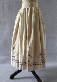
Skirt, late-nineteenth century & 1950s
This skirt belonged to Olga Black, a long-time Brighton resident. The linen used for the skirt were woven by Olga's great-grandmother Efstathia in the late-nineteenth century with flax grown on the island of Ithaca. In the 1950s, Olga made the fabric into a skirt, embellishing it with hand embroidery. Olga Maria Black was born in Melbourne in 1930, the daughter of Ithacan migrants Constantine and Toula Mavrokefalos. Constantine first emigrated to Australia in 1902, returning to Greece circa 1912-13 to serve his home country in the Balkan Wars. Toula's family had left Ithaca for Romania when she was only six months old, but she happened to be visiting the island at the very time that Constantine arrived, fresh from the war. Within three weeks they were married, and when Constantine returned to Melbourne in 1914 his new bride came with him. Constantine had trained as an accountant, but his qualifications were not recognised in Australia. Changing his surname to the Anglicised "Black", he started off working in his older brother Dionysios's cafés before going into business on his own. In 1917 he opened the Paris Residential Café at 54-56 Swanston Street, which offered both dining and accommodation. The business saw some years of success, but did not survive the Great Depression. Constantine died in 1944. Olga's mother Toula learned to sew as a child, while growing up in the Romanian village of Brila. She developed her skills making lace and embroidering items for her trousseau. Some of the linen she embroidered had been woven from flax on Ithaca by her own grandmother, Efstathia. During the Depression, when money was scarce, Toula embroidered at home, doing work for a factory in Flinders Lane. Using a cotton reel, a threepence and a sixpence she created and embroidered designs on hundreds of blouses. Olga spent her preschool days sitting at the table where her mother worked. Toula would involve Olga by allowing her to help choose the colour combinations. Toula lived with Olga in Brighton until her death in 1976. Olga inherited her mother's sewing skills. She re-invented some of Toula’s trousseau nightdresses and skilfully altered other clothing, making dresses which she wore around Brighton for many years.Ankle-length full cream linen skirt with multi-coloured cross stitch embroidery featuring mountains, birds and trees. Fullness is pleated into wide waist band. Left side opening. The fabric widths have been whipped together by hand probably at the time the cloth was woven in the late-nineteenth century. The skirt is machine stitched.skirt, linen, hand woven, embroidery, ithaca, migration, greek diaspora, olga black -
 Brighton Historical Society
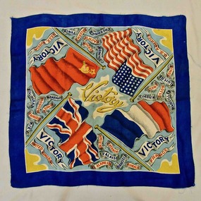
Scarf, Victory scarf, circa 1945
This scarf belonged to Olga Black, a longtime Brighton resident. Olga Maria Black was born in Melbourne in 1930, the daughter of Ithacan migrants Constantine and Toula Mavrokefalos. Constantine first emigrated to Australia in 1902, returning to Greece circa 1912-13 to serve his home country in the Balkan Wars. Toula's family had left Ithaca for Romania when she was only six months old, but she happened to be visiting the island at the very time that Constantine arrived, fresh from the war. Within three weeks they were married, and when Constantine returned to Melbourne in 1914 his new bride came with him. Constantine had trained as an accountant, but his qualifications were not recognised in Australia. Changing his surname to the Anglicised "Black", he started off working in his older brother Dionysios's cafés before going into business on his own. In 1917 he opened the Paris Residential Café at 54-56 Swanston Street, which offered both dining and accommodation. The business saw some years of success, but did not survive the Great Depression. Constantine died in 1944. Olga's mother Toula learned to sew as a child, while growing up in the Romanian village of Brila. She developed her skills making lace and embroidering items for her trousseau. Some of the linen she embroidered had been woven from flax on Ithaca by her own grandmother, Efstathia. During the Depression, when money was scarce, Toula embroidered at home, doing work for a factory in Flinders Lane. Using a cotton reel, a threepence and a sixpence she created and embroidered designs on hundreds of blouses. Olga spent her preschool days sitting at the table where her mother worked. Toula would involve Olga by allowing her to help choose the colour combinations. Toula lived with Olga in Brighton until her death in 1976. Olga inherited her mother's sewing skills. She re-invented some of Toula’s trousseau nightdresses and skilfully altered other clothing, making dresses which she wore around Brighton for many years.Victory scarf with the flags of France, the United Kingdom, USA and the USSR. 'Victory' printed in yellow in the centre surrounded by names of countries and regions.scarf, world war ii, second world war, 1945, olga black