Showing 3157 items matching "south west"
-
 Phillip Island and District Historical Society Inc.
Photograph, Bryant West
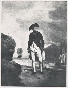
One of a collection of over 400 photographs in an album commenced in 1960 and presented to the Phillip Island & Westernport Historical Society by the Shire of Phillip IslandPhotograph of a painting by F Wheatley National Portrait Gallery, of Vice Admiral Arthur Phillip standing on beach between water and rocks. Small boat with sailor nearby and ship under sail in background.Vice Admiral Arthur Phillip - first Governor of New South Wales. The man after whom Phillip Island was named.local history, photography, photographs, exploration, maritime, governor arthur phillip, arthur phillip, john jenner, bryant west -
 Phillip Island and District Historical Society Inc.
Photograph, Bryant West
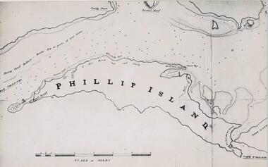
... documents maps phillip island john jenner bryant west Photograph ...One of a collection of over 400 photographs in an album commenced in 1960 and presented to the Phillip Island & Westernport Historical Society by the Shire of Phillip IslandPhotograph of a Map of Phillip Island. The first to show Fort Dumaresq, track to beach and beginning of road to South coast. local history, photography, photographs, exploration, maritime, documents, maps, phillip island, john jenner, bryant west -
 Phillip Island and District Historical Society Inc.
Photograph, Bryant West
... Woolamai looking south east. Photograph Bryant West ...One of a collection of over 400 photographs in an album commenced in 1960 and presented to the Phillip Island & Westernport Historical Society by the Shire of Phillip IslandPhotograph of Cape Woolamai looking south east.local history, photography, photographs, coastline, cape woolamai, phillip island, john jenner, bryant west -
 Phillip Island and District Historical Society Inc.
Photograph, 1910
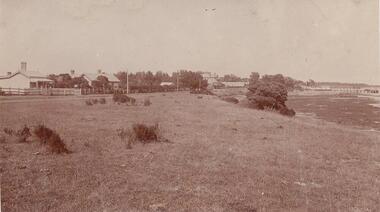
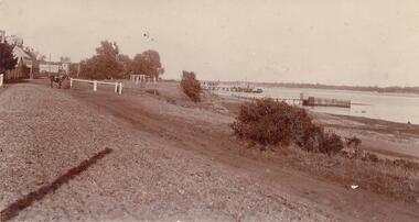
One of a collection of over 400 photographs in an album commenced in 1960 and presented to the Phillip Island & Westernport Historical Society by the Shire of Phillip IslandPhotograph of San Remo looking south along the foreshore showing some houses. Reef exposed by low tide. Jetty in background.local history, photography, photographs, san remo and foreshore, sepia photograph, san remo, foreshore, jetty, john jenner, bryant west -
 Phillip Island and District Historical Society Inc.
Photograph
... west Photograph looking south along the waterfront of San Remo ...One of a collection of over 400 photographs in an album commenced in 1960 and presented to the Phillip Island & Westernport Historical Society by the Shire of Phillip IslandPhotograph looking south along the waterfront of San Remolocal history, photography, photographs, san remo and foreshore, sepia photograph, san remo, waterfront, john jenner, bryant west -
 Phillip Island and District Historical Society Inc.
Photograph, Bryant West
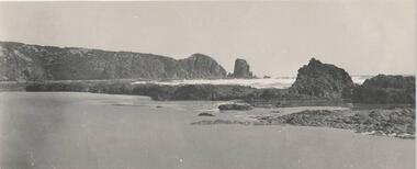
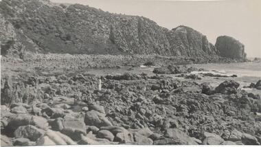
One of a collection of over 400 photographs in an album commenced in 1960 and presented to the Phillip Island & Westernport Historical Society by the Shire of Phillip IslandPhotograph of Rocks and Beach south side of Cape Woolamai.local history, photography, photographs, coastline, rocky beach, reef, cape woolamai, phillip island, reefs, john jenner, bryant west -
 Phillip Island and District Historical Society Inc.
Photograph, Circa 1900
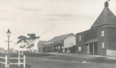
... Island local history photography photographs chicory kiln west's ...One of a collection of over 400 photographs in an album commenced in 1960 and presented to the Phillip Island & Westernport Historical Society by the Shire of Phillip IslandPhotograph looking south of Thompson Avenue, Cowes - depicting first Chicory Kiln and West's Store about 1900.local history, photography, photographs, chicory kiln, west's store, black & white photograph, phillip island, cowes, chicory kilns, thompson avenue cowes, john jenner, bryant west -
 Phillip Island and District Historical Society Inc.
Photograph, Bryant West
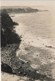
One of a collection of over 400 photographs in an album commenced in 1960 and presented to the Phillip Island & Westernport Historical Society by the Shire of Phillip IslandPhotograph from cliff top of rocky south coastline looking easterlylocal history, photography, photographs, coastline - south coast, south coast, cliffs, south coast phillip island, john jenner, bryant west -
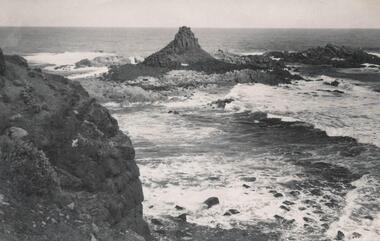 Phillip Island and District Historical Society Inc.
Photograph, Bryant West
One of a collection of over 400 photographs in an album commenced in 1960 and presented to the Phillip Island & Westernport Historical Society by the Shire of Phillip IslandPhotograph of Pyramid Rock looking south from cliff toplocal history, photography, photographs, coastline - rock formation - pyramid rock, coastline, south coast, pyramid rock, john jenner, bryant west -
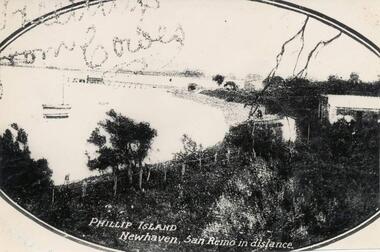 Phillip Island and District Historical Society Inc.
Photograph
One of a collection of over 400 photographs in an album commenced in 1960 and presented to the Phillip Island & Westernport Historical Society by the Shire of Phillip IslandPhotograph of Fowlers Bay, Newhaven, taken looking south-east and showing some moored boats. The Newhaven jetty and San Remo in the background.local history, photography, photographs, fowlers bay, newhaven, black & white photograph, phillip island coastline, fowlers bay newhaven, san remo, john jenner, bryant west -
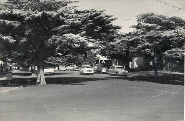 Phillip Island and District Historical Society Inc.
Photograph, 1960
One of a collection of over 400 photographs in an album commenced in 1960 and presented to the Phillip Island & Westernport Historical Society by the Shire of Phillip IslandPhotograph taken in 1960 and looking south along Thompson Avenue, Cowes.local history, photography, thompson avenue, cowes, black & white photograph, thompson avenue cowes, john jenner, bryant west -
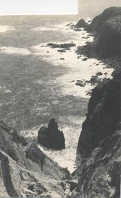 Phillip Island and District Historical Society Inc.
Photograph, Bryant West
... Photograph of Rocky south coast shoreline. Photograph Bryant West ...One of a collection of over 400 photographs in an album commenced in 1960 and presented to the Phillip Island & Westernport Historical Society by the Shire of Phillip IslandPhotograph of Rocky south coast shoreline.local history, photography, photographs, coastline, phillip island, southern coastline phillip island, john jenner, bryant west -
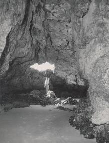 Phillip Island and District Historical Society Inc.
Photograph, Bryant West
One of a collection of over 400 photographs in an album commenced in 1960 and presented to the Phillip Island & Westernport Historical Society by the Shire of Phillip IslandPhotograph inside Forrest Caves South Coast Phillip Island. Man inside looking out. local history, photography, photographs, coastline, caves, phillip island, forrest caves phillip island, john jenner, bryant west -
 Mission to Seafarers Victoria
Letter - Correspondence, My Darling Mum, 23rd April, 1945
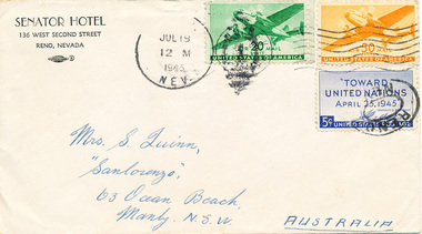
The letter was written by Allen Quinn to his mother. Allen started working as a seafarer when he was 16 years old, and frequently wrote to his mother during his travels. He also created an extensive photograph collection, which corresponds with the letters.The letter is part of an ongoing correspondence between Allan and his mother. This letter mentions the S.S 'Morgenster', the South African ship Allan was working on at the time, and also which he was signed off from because of South African law.Letter addressed to Mrs S. Quinn, "Sanlorenzo", 63 Ocean Beach, Manly, N.S.W, Australia, in three parts. Part 0152.1 Envelope Part 0152.2 Letter Page, 0152.3 Letter Page. Both the envelope and letter were white paper, which is now a yellow-white. The letter begins "My darling Mum, I hope that you have not worried..." and concludes with "Your loving son, Allan...". Printed across the top of 0152.2: SOUTH AFRICAN MARINE CORPORATION, and handwritten beneath: S.S 'Morgenster', 23rd April, Baltimore.Front of envelope: SENATOR HOTEL / 136 WEST SECOND STREET / RENO, NEVADA (printed) / MRS. S. QUINN, / "SANLORENZO", / 63 OCEAN BEACH, / MANLY, N.S.W., AUSTRALIA (handwritten in blue ink). In the top right hand corner are three U.S.A stamps, for the value of 5, 20 amd 50 cents.. In the middle of the top of the envelope is a stamped postmark: JUL 18 / 12 M / 1945 / NEV. Back of envelope: A. QUINN / MV. JOONAWARRA / 61 (indecipherable) STEAMSHIP SO. / SAN FRANCISCO, CAL. U.S.A (handwritten in blue ink).allan-quinn, letter, handwriting, south-africa -
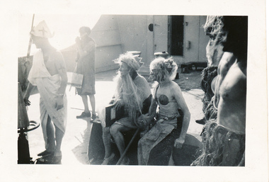
 Mission to Seafarers Victoria
Photograph - Photograph, Black and white, Allan Charles Quinn, Crossing the line on the Ariston, 10 September 1946
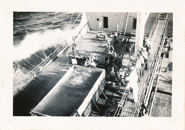
... and worked between Sweden, Central America, North West Indies... central-america north-west-indies south-america equator ariston ...This photograph depicts the ritual of "crossing the line" which marks the point at which a sailor first crosses the equator. Allan worked aboard the M.T. Ariston during 1946 and worked between Sweden, Central America, North West Indies and South America.This photograph is from the Allan Charles Quinn collection which is a collection of letters and photographs depicting life at sea for a young man in the period immediately following World War II.Black and white photograph of the "crossing the line" ceremony aboard the Ariston.Black ink on reverse: Crossing the equator on Ariston/ 10.9.46allan-charles-quinn, crossing-the-line, sweden, central-america, north-west-indies, south-america, equator, ariston -
 Mission to Seafarers Victoria
Photograph - Photograph, Black and white, Allan Charles Quinn, Crossing the line on the Ariston, 10 September 1946
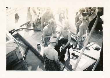
... central-america north-west-indies south-america equator ariston ..."Crossing the line" ceremonies were routinely conducted when a crew member made their first crossing of the equator. This photograph depicts aspects of that ceremony and, as Allan Charles Quinn is the photographer, it is obviously not his first crossing. This photograph was exhibited by the Mission to Seafarers as part of the exhibition "Letters from Abroad" in 2012.This photograph is from the Allan Charles Quinn collection which is a collection of letters and photographs depicting aspects of the life of a young man who went to sea in the period immediately following World War II.Black and white photograph depicting aspect of the "crossing the line" ceremony performed at sea on the Ariston. This ceremony was performed to mark a person's first crossing of the equator.Black ink on reverse: Crossing the equator 10.9.46allan-charles-quinn, crossing-the-line, sweden, central-america, north-west-indies, south-america, equator, ariston, letters-from-abroad -
 Mission to Seafarers Victoria
Photograph - Photograph, Black and white, Allan Charles Quinn, Crossing the line on the Ariston, 10 September 1946
... -the-line sweden central-america north-west-indies south-america ..."Crossing the line" was an important maritime ritual and denoted the first crossing of the equator by a sailor. This photograph has been taken by Allan Charles Quinn and obviously is not his first crossing but depicts aspects of the ceremony, in particular the way in which crew members would dress up to represent King and Queen Neptune. This photograph was exhibited by the Mission to Seafarers as part of the exhibition "Letters from Abroad" in 2012.This is a photograph from the Allan Charles Quinn collection which is a collection of letters and photograph depicting aspects of life at sea for a young man in the era immediately following World War II.Black and white photograph of the "crossing the line" ceremony aboard the Ariston in 1946. Crew members are dressed as King and Queen Neptune.Black ink on reverse: Crossing the equator/ 10.9.46allan-charles-quinn, crossing-the-line, sweden, central-america, north-west-indies, south-america, equator, ariston, letters-from-abroad -
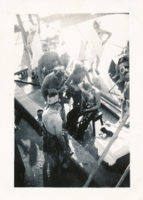 Mission to Seafarers Victoria
Photograph - Photograph, Black and white, Allan Charles Quinn, Crossing the line on the Ariston, 10 September 1946
... sweden central-america north-west-indies south-america equator ...The crossing the ceremony was an important part of maritime lore and marked a sailor's first crossing of the equator. This photograph was taken by Allan Charles Quinn and therefore it is presumably not his first crossing but the photograph does depict aspects of the ceremony.This photograph is from the Allan Charles Quinn collection which is a collection of letters and photographs depicting life at sea for a young man in the period immediately after World War II.Black and white photograph of various members of the crew of the Ariston participating in the "crossing the line" ceremony in 1946.Black ink on reverse: Crossing the equator/ on Ariston/ 10.9.46allan-charles-quinn, crossing-the-line, sweden, central-america, north-west-indies, south-america, equator, ariston -
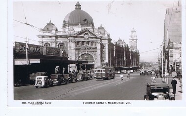 Greensborough Historical Society
Postcard, Flinders Street Melbourne, 1930s
Flinders Street Melbourne, facing west, Flinders Street Station to the south.Rose Series postcardBlack and white photograph, correspondence and address spaces on reverseRose Series P. 210melbourne, flinders street melbourne, flinders street station -
 Greensborough Historical Society
Map, Municipality of Heidelberg Plan No. 480, 17/10/1948
Map shows streets, buildings, river and major drainage easements in area covered by West boundary Sellars Street, North boundary Yando Street & South boundary Grimshaw Street. Adjoins Map No. 481 to East. Black & white map, features marked in green, gradients in red. Scale: 160 feet to 1 inchgreensborough -
 Greensborough Historical Society
Map, Municipality of Heidelberg Plan No. 481, 23/9/1949
Central area of Greensborough, South boundary Grimshaw Street, showing river and buildings in green and gradients in red. Adjoins Map No. 480 to West.Black & white map with features in red and green. Scale: 160 feet to 1 inch.greensborough, grimshaw street greensborough -
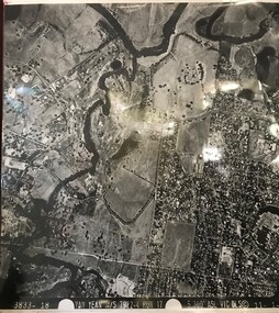 Greensborough Historical Society
Aerial Photograph, Yan Yean M/S 7922 Run 17 No. 3833-18, 1/11/1984
Covers Viewbank area: North boundary Martin's Lane; South boundary Yarra River & Birrarung Park; East boundary east of Plenty RiverLaminated black and white aerial photograph; adjoins 6227 on west sideviewbank -
 Glenelg Shire Council Cultural Collection
Photograph - Photograph - Portland Lifeboat, n.d
Built in 1858 at the Port and Harbour Master's yard in Williamstown Victoria, the Portland Lifeboat was overseen by Harbour Master Charles Ferguson. It is understood to have been constructed from the same moulds used to build the Port Fairy Lifeboat, designed by William White, in 1857. Both boats are similar to the lifeboats designed in England by James Peake and adopted by the Royal National Lifeboat Institution (RNLI) in the UK. The Portland Lifeboat's 9.14 m (30 ft) long hull is double diagonally planked in New Zealand kauri, and many of the planks run from gunwale to gunwale in one piece under the inner keel section. Eucalyptus and oregon were used elsewhere and the local blacksmith made the iron work. The fastenings are copper. There are two flotation or buoyancy tanks at either end, with prominent whaleback style decking. Under the thwarts is a deck with scuppers so that the craft is both buoyant and self draining whenever large waves are taken aboard in rough conditions. The lifeboat was oar-powered with a sailing rig. The original rig was a lug mainsail, but this was replaced with a lug and headsail rig taken from a fishing boat in 1903. The lifeboat was manned by volunteer crews, mostly local fishermen from Portland. They maintained this service until 1915 when the boat was replaced with a new motorised craft. The lifeboat's most outstanding service was to the steamer ADMELLA in 1859 when the ship grounded on a reef off Cape Banks in South Australia, 150 km to the west of Portland. Survivors clung to the rigging in heavy seas for over a week and 89 people lost their lives in the shipwreck. Taken to the scene by the steamer LADY BIRD, the Portland Lifeboat was unable to assist until eight days after the ADMELLA's grounding when the seas abated enough for the lifeboat to manoeuvre close to the ship and rescue the last 19 survivors. Since its retirement in 1915 the lifeboat has been a memorial to those who manned it and those it rescued. For a long period it was on display in the Portland Gardens, first in the open and then under a canopy. In 2008 it was on display inside the Portland Maritime Discovery Centre, still in original condition complete with the rig from 1915. It is one of the oldest vessels of its type in Australia, and the world.Portland LifeboatPhotograph showing the Portland Lifeboatphotography, portland lifeboat, admella -
 Glenelg Shire Council Cultural Collection
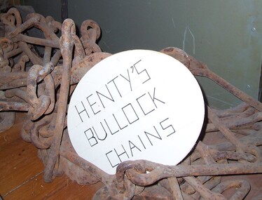
Functional object - Chains - bullock harness, n.d
Thought to be the chains used for the Henty's bullock harness. The Henty family are known as Victoria's earliest European settlers and pastoralists, emigrant squatters who played a defining role in the establishment of Portland and the development of the region's wool trade. Facing challenges as a farmer in early 19th-century England, West Sussex grazier Thomas Henty (1775–1839) turned his sights south to the colonies, where he believed his seven sons would have a brighter future as sheep breeders and wool producers. He had been the first to introduce merino to the south of England, and would do so in the colonies also.Thought to be the chains used for the Henty's bullock harness.Iron chains with fittings for bullock harnesses.farming, rural industry, henty, bullock, chains -
Glenelg Shire Council Cultural Collection
Photograph, n.d
Black and white photo mounted on grey card. Photo taken from middle of intersection of Percy and Julia St's. St. Stephens Anglican Church in centre, fire station, 'Annesley' and Dr. Grier's house in Julia St, west: Plume garage, other shops in Percy St. south.Back: 'B. Vivian' - pencil -
Glenelg Shire Council Cultural Collection
Booklet - Booklet - The Seaside Calls, n.d
Sixteen page booklet, issued by Victorian Railways Publicity and Tourist Services, Melbourne. Information on Victorian seaside towns, from Mallacoota Inlet on the east to the South Australian border in the west.Front: 'VIVIAN' - handwritten, biro, top right. -
 City of Moorabbin Historical Society (Operating the Box Cottage Museum)
Document - Genealogy Chart Henry Dendy (Photocopy), 19 thC
In 1840 Henry Dendy, a farmer in Surrey, England acquired a "Special Survey" from the Commissioners for Land and Emigration which gave Dendy the right to choose land in Port Phillip for the "bargain basement" price of only £1 per acre for 5120 acres, (an area of 8 square miles). The Special Survey also included the right to "the shipment of a worker for every £20 spent on land, whose free passage was paid by the Crown, equalling a total of 100 workers ". Accordingly Dendy sold his English holdings and paid the required £5120 and arrived in Melbourne in February 1841. However by this time land in the new colony was selling for £5 - £40 per acre. Because Henry Dendy possessed the order from the Colonial Office in London he was able to successfully oppose Super-intendant LaTrobe's attempts to alter the price of the land. Dendy appointed Jonathan Were, (an entrepreneur, who had arrived in 1839), as his Manager and who later became a partner. Together, Dendy and Were decided on an area 5 miles south from Melbourne, bounded by North Road, East Boundary Road, South Road and to the west by Port Phillip Bay. Were and Dendy pitched their tents in the area now known as ' Park St, Brighton' and sank a well near the corner of 'St Andrew's St and Wells St'. By 1845 J.B Were and Company had bought almost half of Dendy's land and Were built himself "Moorabbin House" in Were St Brighton made from stone, quarried from local cliffs. It was still standing in 1924. Legend records Moorabbin is named after the Aboriginal word for ' Mother's Milk ' The soil is very fertile and well supplied with water especially in the area called 'East Brighton' - now known as Bentleigh and East Bentleigh - By 1850 the area had developed with numerous market gardens, dairy farms, fruit gardens and vineyards supplying food for the growing population of Melbourne.In 1840 Henry Dendy, a farmer in Surrey, England acquired a "Special Survey" from the Commissioners for Land and Emigration which gave Dendy the right to choose land in Port Phillip for the price of only £1 per acre for 5120 acres. This land was called Brighton in the Parish of Moorabbin, County of Bourke and emigrants developed the land establishing market gardens , dairy and poultry farms that provided the food for the growing population of Melbourne. A photocopy of the Genealogy Chart of the Dendy Family that Henry Dendy brought with him when he emigrated to Melbourne 1841Genealogy signs and descriptionsdendy henry, dendy's special survey brighton 1841, governor gipps, captain lonsdale, super-intendant latrobe, port phillip, melbourne, new south wales, squatters, emmigrants, county of bourke, parish of moorabbin, early settlers, pioneers, market gardeners, dairy farmers, fruit farms, moorabbin, bentleigh, brighton, cheltenham, were jonathan binn, -
City of Moorabbin Historical Society (Operating the Box Cottage Museum)
Document, Henry Dendy family Shield
In 1840 Henry Dendy, a farmer in Surrey, England acquired a "Special Survey" from the Commissioners for Land and Emigration which gave Dendy the right to choose land in Port Phillip for the "bargain basement" price of only £1 per acre for 5120 acres, (an area of 8 square miles). The Special Survey also included the right to "the shipment of a worker for every £20 spent on land, whose free passage was paid by the Crown, equalling a total of 100 workers ". Accordingly Dendy sold his English holdings and paid the required £5120 and arrived in Melbourne in February 1841. However by this time land in the new colony was selling for £5 - £40 per acre. Because Henry Dendy possessed the order from the Colonial Office in London he was able to successfully oppose Super-intendant LaTrobe's attempts to alter the price of the land. Dendy appointed Jonathan Were, (an entrepreneur, who had arrived in 1839), as his Manager and who later became a partner. Together, Dendy and Were decided on an area 5 miles south from Melbourne, bounded by North Road, East Boundary Road, South Road and to the west by Port Phillip Bay. Were and Dendy pitched their tents in the area now known as ' Park St, Brighton' and sank a well near the corner of 'St Andrew's St and Wells St'. By 1845 J.B Were and Company had bought almost half of Dendy's land and Were built himself "Moorabbin House" in Were St Brighton made from stone, quarried from local cliffs. It was still standing in 1924. Legend records Moorabbin is named after the Aboriginal word for ' Mother's Milk ' The soil is very fertile and well supplied with water especially in the area called 'East Brighton' - now known as Bentleigh and East Bentleigh - By 1850 the area had developed with numerous market gardens, dairy farms, fruit gardens and vineyards supplying food for the growing population of Melbourne. dendy henry, dendy's special survey brighton 1841, governor gipps, captain lonsdale, super-intendant latrobe, port phillip, melbourne, new south wales, squatters, emmigrants, county of bourke, parish of moorabbin, early settlers, pioneers, market gardeners, dairy farmers, fruit farms, moorabbin, bentleigh, brighton, cheltenham, were jonathan binn, -
 City of Moorabbin Historical Society (Operating the Box Cottage Museum)
Document - Pedigree of Henry Dendy, c1840 Original ; Copy 1985
This is a copy of the document brought by Henry Dendy to the Colony in 1841. In 1840 Henry Dendy, a farmer in Surrey, England acquired a "Special Survey" from the Commissioners for Land and Emigration which gave Dendy the right to choose land in Port Phillip for the "bargain basement" price of only £1 per acre for 5120 acres, (an area of 8 square miles). The Special Survey also included the right to "the shipment of a worker for every £20 spent on land, whose free passage was paid by the Crown, equalling a total of 100 workers ". Accordingly Dendy sold his English holdings and paid the required £5120 and arrived in Melbourne in February 1841. However by this time land in the new colony was selling for £5 - £40 per acre. Because Henry Dendy possessed the order from the Colonial Office in London he was able to successfully oppose Super-intendant LaTrobe's attempts to alter the price of the land. Dendy appointed Jonathan Were, (an entrepreneur, who had arrived in 1839), as his Manager and who later became a partner. Together, Dendy and Were decided on an area 5 miles south from Melbourne, bounded by North Road, East Boundary Road, South Road and to the west by Port Phillip Bay. Were and Dendy pitched their tents in the area now known as ' Park St, Brighton' and sank a well near the corner of 'St Andrew's St and Wells St'. By 1845 J.B Were and Company had bought almost half of Dendy's land and Were built himself "Moorabbin House" in Were St Brighton made from stone, quarried from local cliffs. It was still standing in 1924. Legend records Moorabbin is named after the Aboriginal word for ' Mother's Milk ' The soil is very fertile and well supplied with water especially in the area called 'East Brighton' - now known as Bentleigh and East Bentleigh - By 1850 the area had developed with numerous market gardens, dairy farms, fruit gardens and vineyards supplying food for the growing population of Melbourne. A copy of a paper chart of the Pedigree of Henry Dendy in a wooden frame with glassPedigree / of the branch of the family / DENDY moorabbin, brighton, henry dend special survey 1841 y, early settlers, pioneers, market gardeners -
 City of Moorabbin Historical Society (Operating the Box Cottage Museum)
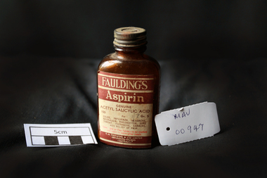
Manufactured Glass, brown bottle 'Fauldings Aspirin', c1950
Francis Hardy Faulding 1816 – 1868 arrived in Sydney 1842. He was a Surgeon on the emigrant ship Nabob. 1845 Francis Hardy Faulding opened his first pharmacy at 5 Rundle Street in Adelaide and the business prospered. In 1867 he formed F.H Faulding & Co with Luther Scammel. as wholesale druggists and manufacturing chemists. Two of the Faulding company's major innovations were the development of a process for distillation of eucalyptus oil, and the development of the test for determining the eucalyptol content of the oil. Faulding's success was founded on eucalyptus oil, which formed the basis of an antiseptic marketed as "Solyptol" In 1868 Francis Hardy Faulding died, aged 52 at his suburban Glen Osmond home in Adelaide. Scammel’s two sons took over the business in 1888 and in 1890 the Company expanded to West Australia, then Sydney, Brisbane and finally, in 1924, Faulding began operations in Exhibition Street, Melbourne, eventually adding wholesale activities. 1986 With a presence in every city, from Darwin to Tasmania. Faulding becomes a truly national company. 2008 Zuelllig Group takes control Focusing solely on pharmaceutical wholesaling and distribution, Hong Kong based Zuelllig Group takes over control of Symbion Pharmacy Services. 2008 Symbion Pharmacy Services exceeds $3 billion with one of the country's largest networks of warehousing systems and service A brown glass, bottle with a metal screw top containing ‘Faulding's Aspirin’ tabletsFront label : FAULDINGS / ASPIRIN / GENUINE / ACETYL SALICYLIC ACID / 100 Gr 5 / for / Colds, .............. / DOSE ........... / F.H.FAULDING & CO LTD / MANUFACTURING CHEMISTS / AUSTRALIApharmacy, medicines, faulding f.h., scammell luther, faulding's aspirin, glassware, bottles, moorabbin, bentleigh, cheltenham, antiseptics, analgesics, pharmaceuticals, south australia, ss nabob, f.h.faulding & co.