Showing 2514 items
matching tower
-
 Federation University Historical Collection
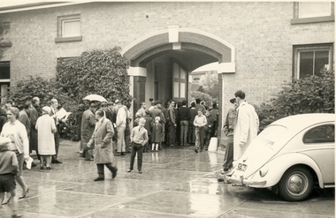
Photograph - Photograph - Black and White, W.G.(Geoff) Little, Open Day at the Former Ballarat Gaol, 1964, 07/03/1964
On 7 March 1964 the Former Ballarat Gaol was opened to the public resulting in a large turnout. These photos were taken during the visit and show various sections, inside and outside, of the gaol. .1) Shows the ground queued up; .2) Front entrance, people starting to move inside; .3) Looking through the bars; .4) view of the curved wall with sentry's walk and guard's tower; .5) Looking through bars to stone wall; .6) Walking down the narrow steps from the top of the wall. This would have been used by guards; .7) Area showing the individual cell doors; .8) People in cell area. An upper level is shown. The gallows is on this level; .9) Stairs leading up to the gallows; .10) Turret above the cell block; .11) Cell area; .12) Cobbled area.Twelve black and white images taken at the open day of the Former Ballarat Gaol, held by the Ballarat Branch of the National Trust on 7 March 1964.ballarat gaol, ballarat school of mines, gaol, bluestone, national trust tours, entrance to gaol, sentry's walk, guard's tower, cells, gallows, stairs to gallows, cobbled area, geoff little -
 Federation University Historical Collection
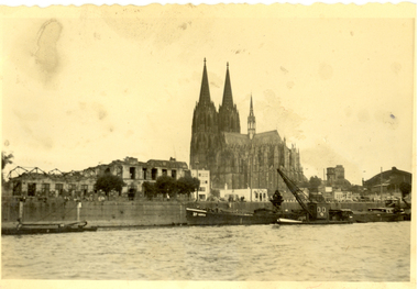
Photograph - black and white, Cologne Cathedral from the Rhine, c1950
Cologne Cathedral is a renowned monument of German Catholicism and Gothic architecture and is a World Heritage Site. It is Germany's most visited landmark, attracting an average of 20,000 people a day. (Wikipedia) Though not targeted itself, the cathedral was very near to the central railway station and suffered fourteen hits by aerial bombs during World War II. Badly damaged, it nevertheless remained standing in an otherwise completely flattened city. The twin spires were an easily recognizable navigational landmark for Allied aircraft bombing deeper into Germany, which may explain why the cathedral was spared. Repairs were completed in 1956. An emergency repair on the northwest tower's base carried out in 1944 using poor-quality brick taken from a nearby ruined building remained visible until 2005 as a reminder of the war, when it was decided to restore the section its original appearance. (Wikipedia) Black and white photograph showing a grand cathedral from a waterway. It is Cologne (Koln) Cathedral from the Rhine. To the left of the photo bombed buildings are evident. The photograph is believed to have been taken by Frank Wright.cologne cathedral, koln, germany, rhine, bombing, world war two, frank wright -
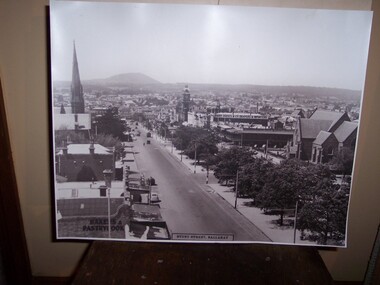
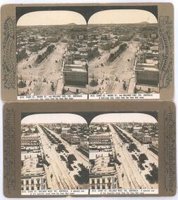
 Ballarat Tramway Museum
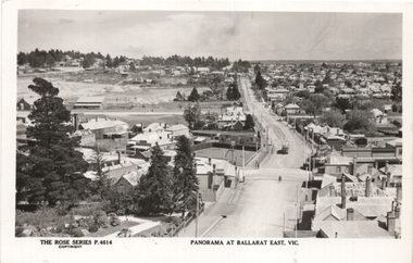
Postcard, Rose Stereograph Co, "Panorama at Ballarat East Vic", c1916
Photo looks west from the Ballarat Fire Station (East) tower, and has a good view looking along Barkly St. Shows the crossing loop between Eastwood and Main St with one tram in the view. Wal has dated the photo as 1914 in his album notes. On rear Wal Jack has written "Looking up Barkly St towards Mt Pleasant. Photo taken from Ballarat Fire Station about 1914-1916 period. Old type tram from Mt Pleasant about to turn into Main St. Note old passing loop behind tram. Loop removed to top of rise in centre background. Old Ballarat East Gardens on left and council yards, showing big tin shed in centre of picture. Locality much altered today." See item 5127 for a digital image.Yields information about the buildings and scene looking west from the Fire Station tower along Barkly St. East BallaratPostcard Black and white - Rose Series No P4614, Divided back. No publishers details on rear.See image 2 for Wal Jack's notes.tramways, trams, esco, ballarat east, barkly st -
 Bendigo Historical Society Inc.
Document - DAVID BANNEAR, THE GOLDFIELDS LANDSCAPE - PROPOSED TALK, 2/11/2023
The goldfields resulted in the almost complete denuding of trees for access to the gold bearing land, for firewood and for the tanning industry. The need for wood further increased with the advent of deep quartz mining that required timbers for shoring up the shafts and tunnels. At some point in time it became necessary for timber to be carted long distances to fulfil the need. Between 1878 and 1884, the government set up 5 nurseries to try and rectify the shortage of native softwoods and encouraged the growth of State plantations and the thinning of trees to encourage growth of those remaining. 1907 - Creswick School of Forestry and Forest Management was started 1919 Establishment of the Forests Commission and the planting of many pine plantations 1924 Establishment of the first fire spotting towers Forest management tasks became a main project for "Susso" recipients during the Great Depression and again for internees during WWII.An 8 page document by David Bannear about the various industries of the Bendigo Goldfields and their effects on terraforming the local environment david bannear, central goldfields -
 Vision Australia
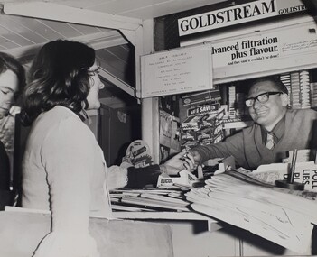
Photograph (item) - Image, Help required for Carols by Candlelight
Carols by Candlelight required the assistance of the general public around Melbourne to sell programs and other items, assist ticket sales and other activities. Various avenues were used to call for this assistance, including the circulation of Help Wanted signs at newsagent kiosks at metropolitan railway stations. In this image, a woman buys something from a newsagent kiosk, whilst another person waits behind her. The newsagent smiles from behind his stack of papers, beside a Life Savers rack and in front of cigarette towers behind him. Above him is an advertisement for Goldstream tobacco. The sign attached slightly over the tobacco advertisement reads: Help Required for Carols by Candlelight commencing 27th Nov. 5 1/4 hours daily. 6 day week inc. Saturday. For 4 weeks. 80 cents per hour. If interested phone Mr Burke 511381.carols by candlelight, royal victorian institute for the blind -
 Parks Victoria - Gabo Island Lightstation
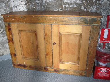
Cabinet
Cupboard is original to Lighthouse. This nineteenth century cedar furnishing has two doors and one internal shelf. It remains in the lighthouse although its original location was probably the lantern room, where similar surviving cabinets are more typically found. It was purpose built for the lighthouse with a curved back to fit the proportions of the tower interior with the wood reputed to have originated from a partition in the assistant lightkeepers’ houses, and the cupboard doors possibly crafted at a different time. Curved cabinets similar to this example can be found at three other early lighthouses investigated by this study. It is possible that these specially designed cabinets were included in the standard complement of furnishings provided to the colony’s lightstations by the Victorian Public Works Department. Other similar cabinets with curved backs remain in the Point Hicks Lighthouse and at Cape Nelson (two examples )and Cape Schanck, which has a curved front as well as back .The Gabo Island cabinet has first level contributory significance for its historic value, uniqueness, provenance to the lightstation and clear association with the functions of the lighthouse lantern room.Two door wooden (cedar) cabinet. One internal shelf, panelled, curved back. Doors are attached. Frame has been stripped, doors are unpainted. -
 Tatura Irrigation & Wartime Camps Museum
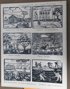
Drawing - Woodcuts, 1943
Camp 3. made by Gudrun and Isolde Frank, camp 3 c.Black and white sketches for calendar. 1943. 6 sketches. 1 - Cloudy sky, with hut and tree to the right and a truck front right; 2 - a guard tower on left hand side, 4 water tanks in Centre and a cloud to the right. front shows some rocks; 3 - Cloudy sky, 2 big trees (one on left and one on right), 3 bare trees in Centre. Across the front are 4 sheep and 4 four posts; 4 - 1 horse in foreground the 3 in back ground with trees in background; 5 - two children picking vegetables with a small hut to the right and a fence in front of 2 trees; 6 - 5 men working in a garden, 1 with wheelbarrow.the number 4 top right hand cornercamp 3, gudrun frank, isolde frank, frank zimmer, camp calendars, templers -
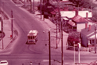
 Ballarat Tramway Museum
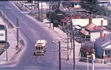
Slide - 35mm slide/s, Glen Mills, Nov. 1970
Agfa plastic mount (blue base, white cover) of a photograph of No. 21 or could be 27 taken from the Ballarat (Ballarat East) Fire Station tower. Photo taken Nov. 1970. Has the sign of the AMPOL service station in the foreground. Has destination of Special. Tram at the intersection of Main St and Barkly Street. One of a set of 20 slides made by the Association of Railway Enthusiast Provincial Tramways film strip. Reference Item 2560 details the ARE Film Strip and provide references to other slides. Photo Glen Mills Slide rescanned at 3200 dpi 25-10-2020, jpg replaced, tiff file retained. This file was scanned in 2003 and may show colour changes."BAS 69" in pencil.tramways, trams, mt pleasant, barkly st, main st, tram 21 or tram 27 -
 Ballarat Tramway Museum
Photograph - Black & White Photograph/s, Victorian Railways, late 1930's (1938?)
Black and White photograph, copy print of Reg. Item 2741, of Sturt St, looking east from the Ballarat City Fire Station tower, late 1930's, possibly 1938. Photo has two trams east bound in the photo, along with a few motor vehicles. In the photo are a street side Garage, a bakery, Golden City Hotel, Town Hall, St. Patricks Church and Harry Davies & Co. Drapers and importers. Has title "Sturt Street, Ballarat". Victorian Railways Photograph - now held by State Library. Original photo will have copyright provisions. Print made by John Phillips c1998 from negative of Reg. Item 2741 on Kodak paper.tramways, trams, sturt st, golden city hotel, st patricks -
 Kew Historical Society Inc
Plan - Subdivision Plan, Bella Vista Estate, 1929
Pru Sanderson, in her groundbreaking ‘City of Kew Urban Conservation Study : Volume 2 - Development History’ (1988), summarised the periods of urban development and subdivisions of land in Kew. The periods that she identified included 1845-1880, 1880-1893, 1893-1921, 1921-1933, 1933-1943, and Post-War Development. These periods were selected as they represented periods of rapid growth or decline in urban development. An obvious starting point for Sanderson’s groupings involved population growth and the associated economic cycles. These cycles also highlighted urban expansion onto land that was predominantly rural, although in other cases it represented the decline and breakup of large estates. A number of the plans in the Kew Historical Society’s collection can also be found in other collections, such as those of the State Library of Victoria and the Boroondara Library Service. A number are however unique to the collection.The Kew Historical Society collection includes almost 100 subdivision plans pertaining to suburbs of the City of Melbourne. Most of these are of Kew, Kew East or Studley Park, although a smaller number are plans of Camberwell, Deepdene, Balwyn and Hawthorn. It is believed that the majority of the plans were gifted to the Society by persons connected with the real estate firm - J. R. Mathers and McMillan, 136 Cotham Road, Kew. The Plans in the collection are rarely in pristine form, being working plans on which the agent would write notes and record lots sold and the prices of these. The subdivision plans are historically significant examples of the growth of urban Melbourne from the beginning of the 20th Century up until the 1980s. A number of the plans are double-sided and often include a photograph on the reverse. A number of the latter are by noted photographers such as J.E. Barnes.Bella Vista (later ‘Malinda’) was a large Federation house designed by the architect Robert Haddon for Abel Hoadley. The house was built in 1902 and occupied the eastern corner of Thomas Street and Cotham Road. It was a single-storey, red brick house, set back from the road, featuring a central tower topped by a pagoda-like red terra cotta roof, on top of which was perched a very large terra cotta dragon. The Bella Vista subdivision of 1929 included Hoadley’s house as well as nine allotments facing Cotham Road and Alfred and Thomas Streets. In 1941, the land on which Hoadley’s house stood was to be further subdivided. Bella Vista is believed to have lasted until it was demolished in the 1980s.subdivision plans - kew, bella vista estate -
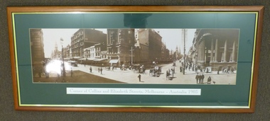 Melbourne Tram Museum
Print - Framed Print, Malvern Framing Gallery, "Corner of Collins and Elizabeth St, Melbourne, Australia 1903", 1997
Framed and glazed photograph of the corner of Collins and Elizabeth Streets Melbourne, looking North East. Wooden frame, brown and gold lining, green card cut to present photograph, with title ""Corner of Collins and Elizabeth St, Melbourne, Australia 1903". Has been lined with brown paper on rear. Two screwed frame hanging supports on either side with four runs of string between them. Has Post Office, Town Hall and Scots Church Towers in the view. One cable car set and one motorised car along with many horse drawn vehicles. Has signed buildings for: Falk Carter & Verner City Hotel M.A Alexander R.H. Alston Blitz's DentistOn rear in black felt pen "$N/XX" and "1997"trams, tramways, melbourne, collins st, cable trams, elizabeth st -
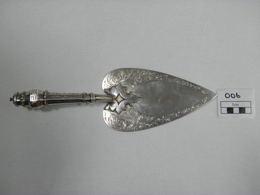 Ballarat Fire Brigade
Trowel, just prior to 01/01/1864
Trowel was presented to Captain Spark by honourable secretary Mr Charles Dyte on 1/1/1864 to lay the foundation stone of the watchtower and belfrey of the Ballarat fire station. Trowel was made by Mr. Bennett of Bridge street and fashioned on the trowel used by Mr. Fraser M.L.C. when laying the foundation stone of the St. Kilda town hallhand engraved sterling silver ceremonial trowel. engraving is floral design on blade. handle is hollow, octaganol with leaf pattern and greek meander patternHallmarked on underside - emu, "WE" (letters), kangarooballarat fire brigade, captain, foundation stone, trowel, colonial silversmith, silver trowel, captain spark, honourable secretary, mr bennet, sterling silver, charles dyte, dyte, spark, 1864, watchtower and belfrey, tower, watchtower, belfrey -
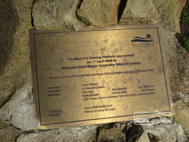 Eltham District Historical Society Inc
Photograph, Liz Pidgeon, Kangaroo Ground War Memorial Park: Plaque, 10 August 2016
Plaque on stone structure acknowledging the Moor-rul viewing platform at Kangaroo Ground War Memorial Park, when it was offically opened on 17 April 2008 with details of names of men and their roles on the advisory committee 2008.Born DigitalNillumbik the Green Wedge Shire The Moor-rul Viewing Platform was opened on 17 April 2008 by Nillumbik Shire Mayor, Councillor Warwick Leeson Kangaroo Ground Memorial Park and Tower of Remembrance Advisory Committee 2008 Covenor: Harry Gilham Councillor: Cr. Warwick Leeson Members: Ken King, Neil Marshall, Alex Melichore Dean Stewart, Dennis Ward, Mick Woiwod John Haines (former member) Nicholas Pelling (former member) Architect: Dennis Ward RAIA ALIA Builder Malcorp Building Services world war 1, war memorials, shire of nillumbik, plaque, moor-rul viewing platform, knagaroo ground, names -
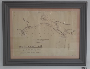 Flagstaff Hill Maritime Museum and Village
Document - Location Chart, The Mahogany Ship, 2007
This chart shows a possible site for the fabled wreck called the 'Mahogany Ship'. Flagstaff Hill’s collection includes other objects that some say could be relics from this Ancient Wreck, (also called the Gold Ship, or the Ancient Vessel). The chart shows the coordinates for the Summits of Griffith Island and of Middle Island. It also has the depths of the sea at various intervals and shows the shore and sand dunes, lighthouses and other reference points. The mystery of the Mahogany Ship began in 1836 when two shipwrecked sealers discovered the remains of an “ancient vessel” in the sand dunes about four miles west of Warrnambool. Since the last recorded sightings in the 1880’s the true origin of the Mahogany Ship has remained one of Australia’s most famous historical mysteries or fables. One of the more recent theories is that the vessel was one of the Portuguese ships exploring the Australian coast in 1522. For over one hundred years searchers have attempted to locate and identify the wreck. The search continues for the tangible evidence which will once and for all establish the Mahogany Ship’s place in Australia’s History.The chart represents the worldwide interest in locating the wreck of the Mahogany Ship. Locating the actual wreck or proving the existence of a Portuguese ship's wreck could change the history of the discovery of Australia. A Mahogany Ship committee was formed to gather and research information about the discovery of the wrecked ship. A large amount of money was offered as a prize for finding the wreck or parts of it. People have written books, painted images, made videos and told tales of the ship but it continues to remain a mystery or even a fable. The chart is significant for its possible link to one of Victoria’s and Australia’s maritime mysteries, the Mahogany Ship (also known as the Ancient Wreck). It is one of very few known relics that could give evidence of the existence and history of the vessel. It is listed on the Victorian Heritage Register S438 as it is one of Victoria’s oldest recorded shipwrecks. The identity of the vessel has the potential to change Australia’s history.A chart in a wooden frame, behind glass. The chart shows the approximate position of the mystery Ancient Wreck, later called the "Mahogany Ship". The chart is a copy and is based on the Admiralty Chart by Lieut. Stanley, dated 1872. Lower left: "THE MAHOGANY SHIP" "LOCALITY PLAN, ENLARGED FROM LIEUT. STANLEY'S ADMIRALTY CHART 1872" "APPROXIMATE POSITION OF WRECK MARKED [symbol of a Portuguese cross]" Other labels on chart: "BELFAST" "PORT FIARY" "GRIFFITHS I" "RIVER MOYNE" "RIVER MERRI" "ARMSTRONG BAY" " GORMANS LANE" "TOWER HILL" "KOROIT" "HELEN ROCK" "WARRNAMBOOL" "LADY BAY" "MIDDLE I" "LIGHT HO." Lower right: "G 410 B" Label on the back; "This chart presented to the Mahogany Ship Committee and Flagstaff Hill by Avis Quarrell, April 2007"warrnambool, shipwrecked coast, flagstaff hill maritime museum, shipwreck coast, mahogany ship, ancient vessel, ancient wreck, portuguese ship, coastal reserve, fabled wreck, gold ship, griffiths island, belfast (now port fairy), koroit, location plan, leuit. stanley, admiralty chart 1872, tower hill, merri river, moyne river, middle island, helen rock, armstrong bay, griffiths land -
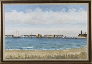 Queenscliffe Maritime Museum
Painting - Oil Painting, Dacre Smyth, 1. 'Queenscliffe' in open shed. 2. 1988 Tall Ships at Queenscliff; Leeuwin, Asgard
Tall Ships at Queenscliff; 'The sail training barquentine "Leeuwin" from West Australia and the Republic of Ireland brigantine "Asgard II" at anchor off Queenscliff prior to the "Arrival Convoy" in Melbourne of a number of the Tall Ships, all bound eventually for Sydney via Hobart for Australia's 1988 bicentenary. The Queenscliff pier with the old lifeboat shed and the Blacklight (Queenscliffe's High Light) alongside the old signal tower are also depicted. Port Phillip Heads in the disctance. By Dacre Smyth 29 Dec 1987.A barquentine or schooner barque is a sailing vessel with three or more masts; with a square rigged foremast and fore-and-aft rigged main, mizzen and any other masts. A brigantine is a two-masted sailing vessel with a fully square-rigged foremast and at least two sails on the main mast: a square topsail and a gaff sail mainsail (behind the mast). The main mast is the second and taller of the two masts.Oil painting in frame of the Leeuwin and Asgard tall ships in Queenscliff 1988.On front: Tall Ships at Queenscliff (LEEUWIN and ASGARD). Hand written on back: Tall Ships at Queenscliff; 'The sail training barquentine "Leeuwin" from West Australia and the Republic of Ireland brigantine "Asgard II" at anchor off Queenscliff prior to the "Arrival Convoy" in Melbourne of a number of the Tall Ships, all bound eventually for Sydney via Hobart for Australia's 1988 bicentenary. The Queenscliff pier with the old lifeboat shed and the Blacklight (Queenscliffe's High Light) alongside the old signal tower are also depicted. Port Phillip Heads in the disctance. By Dacre Smyth 29 Dec 1987'.leeuwin, barquentine, queenscliff, dacre smyth, brigantine -
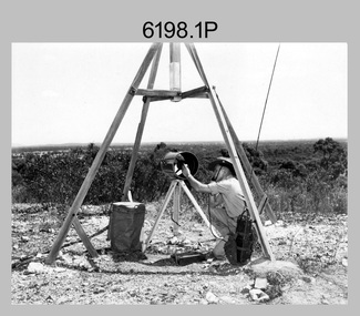 Bendigo Military Museum
Photograph - Royal Australian Survey Corps Electronic Distance Measuring Equipment Demonstration, c1960s
This is a set of five photographs of CAPT James ‘Jim’ Leslie Stedman in the field demonstrating the setup of prisms used as electric distance measurement (EDM) receiver reflectors for tellurometer equipment and the sighting of a large surveyor’s light. This equipment was deployed in establishing mapping and geodetic control operations. The photos were most likely taken in the late 1950s or early 1960s. The tellurometers of this era were man-portable systems that improved geodetic survey efficiencies for rapid network extension and densification replacing triangulation with EDM and theodolite traverse sometimes using Bilby Towers to extend line lengths. Jim Stedman later reached the rank of Colonel, was Director of Military Survey from 1975 to 1978 and was appointed as Colonel Commandant (honorary appointment, Retd) of the Royal Australian Survey Corps from 1978 to 1983. Jim Stedman is demonstrating EDM equipment. See item 6180.16P, photos .14) to .16) for more information and photos of Jim Stedman’s EDM demonstration. This is a set of five photographs of a surveyor in the field demonstrating electric distance measurement (EDM) equipment. c1950s – 1960s. The photographs were printed on photographic paper and are part of the Army Survey Regiment’s Collection. The photographs were scanned at 300 dpi. .1) to .2) - Photo, black & white, c1960s, CAPT Jim Stedman demonstrating the sighting of a large surveyor’s light. .3) to .5) – Photo, black & white, c1960s, CAPT Jim Stedman demonstrating EDM prism equipment. .1P to .5P on back – CAPT Stedman EDM Eqpt.royal australian survey corps, rasvy, army survey regiment, army svy regt, fortuna, asr, surveying -
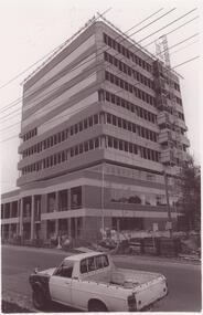 Glen Eira Historical Society
Article - Caulfield Institute of Technology
Four items about the establishment,history and courses provided at this Institute: 1/Research notes (2 pages in all) regarding the renaming of Caulfield Technical School to Caulfield Institute of Technology in 1968 sourced from La Trobe Library Reference Index. Several dates listed. Reference also to article on construction of building in 'Australian Builder' of January 1950. 2/Photocopy of article from 'The Australian Accountant', April 1975. Gives history of C.I.T. and of Business School courses plus photos. (3 pages) 3/Advertising flyer for 'The David Syme Business School at CIT' listing courses for enrolment by 15/12/1978. 4/Undated black and white photograph of building in progress on site of Caulfield Institute/Monash University Caulfield. Noted on reverse'Chisholm Tower', 'Contact June 29, PIC 3 PG3 100% pl2' ie likely taken by photographer for 'Caulfield Contact'.miller j.o. mr. (b.a. b. com. f.a.s.a.), huggan noel, halstead h.j. mr., kurtz david professor, holmes graham, collins mike, chataway graham, erdonmez hassan, gleeson june, voumard lou, coombe jack, caulfield technical college, caulfield technical school, caulfield institute of technology (cit), k.h. boykett building, monash university, dandenong road, caulfield east, victorian education department, school of business, school of applied sciences, school of engineering, school of industrial studies, school of general studies (humanities sociology art and design), technical schools, technical colleges, education, secondary education, mature age students, david syme business school, 'contact' -
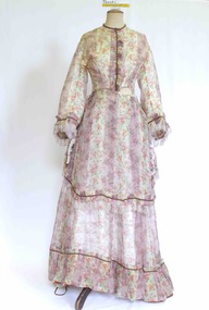 Brighton Historical Society
Clothing - Dress, Day dress, circa 1870
The donor and family of this gown were long-term Brighton residents, and the gowns were held by them as family heirlooms prior to donation to Brighton Historical Society. Originally owned by Elizabeth Emma Adams and Cecilia Elizabeth Adams, it is believed that the dress was brought to Australia by either a half brother, James Smith Adams, or a younger sister, Sophia Charlotte Louisa Adams (later known as Mother Rose Columba Adams). Elizabeth and Cecilia were the daughters of James Smith Adams (a squire, 1780-1860) and Elizabeth Emma McTaggart (1793-1843) of Tower House, Woodchester in Gloucester, a property which Elizabeth later inherited. Originally a monastery, Tower House had been converted into a stately home after the Reformation. According to information originally provided by the donor, both this dress and the dress T0004.3 were made for Elizabeth and Cecilia, to be worn at the young Queen Victoria’s first 'drawing room ball' following the end of court mourning in 1838 for her uncle William IV who died in 1837. In 1838 Cecilia would have been twelve years old and Elizabeth would have been ten years old. It is possible that the dress T0004.3 was worn by one of the girls to this event as it is of appropriate dimensions for a child of that age, although its design is very formal and adult. However, it is unlikely that either of the girls wore this dress at the ball due to the size and styling of the dress. It is likely that the dress belonged to one of the girls, but was worn at a later date. Elizabeth was born on 30 June 1828 at Tower House and died on 1 May 1909. She created a scandal when she eloped with her first husband, Thomas Charles Gardiner at the age of 18. The validity of the marriage was later formally investigate and, while it was confirmed as valid, a second church wedding was subsequently held. Thomas died in 1878. Elizabeth subsequently remarried Reverend R. E. Blackwell, but was widowed again by 1889. Cecilia was born on 17 December 1826 and died in 1902 a spinster recluse in England. At the inquest into Cecelia's death in 1904 it was revealed that she had clearly come from a family of means as her home was filled to the brim with highly valuable goods, many in boxes. She was buried in the family vault at Woodchester. Elizabeth and Cecilia's sister Sophia converted to Roman Catholicism in 1851 and became a nun, taking the religious name 'Rose Columba'. In 1883 Mother Rose Columba led a group of eight to Australia, answering a call for Dominican sisters to nurse the sick in Adelaide. Upon arrival, she founded St. Dominic's Priory and the Church of Perpetual Adoration in North Adelaide, using her inheritance to build the chapel. Elizabeth's second son, George Henry Somerset, who inherited the Adams family estate dropped the 'i' in Gardiner and added the maiden name of his grandmother. Therefore, the family name has now become Gardner McTaggart. These Adams family entries have been updated with information provided by Dr Herbert Gardner McTaggart, great-grandson of George Henry Somerset in April 2016. Mr McTaggart contacted the society after finding our entries online.A hand sewn white purple, pink, green, blue and yellow floral silk chiffon dress from circa 1870. The dress consists of two pieces worn together as a dress. This dress has received a great deal of mending and alteration and so it is difficult to be sure of what constitutes its original state. The following description is of its current state. The bodice has a high neck with a simple shallow band collar, an olive braid and a press stud closure. The bodice fastens down the centre front with ten hook and eyes closures and two sets of ribbon ties . The bodice has three darts providing shaping into the waistline. The bodice finishes at the waist and gently tapers towards the front creating a 'V' line. Down the centre front from the neck to the waist concealing the bodice opening is a pressed pleated ruffle of the dress fabric and a line of olive braid. The dress features pagoda sleeves finished at the hem with pressed pleated ruffle of the dress fabric, a line of olive braid and a silk fringe of 4 cm pale pink and white. The skirt part of the bodice section attaches to the front of the dress with two hooks and eyes on the left hand side of the waist. The fabric drops down to approximately the knees at the front, curving up and splitting on either side over the hip. The edge of this piece is also trimmed with a pressed pleated ruffle of the dress fabric and a line of olive braid. Just below the hip on either side is a large bow of pink, cream, purple and green taffeta. The bodice at the back is shaped with four panels into the waistline. Where it joins the bodice skirt the skirt is pleated, creating fullness. The skirt of the dress ensemble secures at the waist on the left hand side. At the front it has two pleats (that may have been repositioned during repair), and is fully gathered at the back. At the front the dress falls to the floor whilst at the back it is longer to accommodate the bustle and possibly a small train.cecilia elizabeth adams, elizabeth emma adams, 1870s fashion, tower house, woodchester, james smith adams, elizabeth emma mctaggart, mary rose columba adams, sophia charlotte louisa adams -
 Bendigo Historical Society Inc.
Photograph - LA TROBE UNIVERSITY BENDIGO COLLECTION: BENDIGO TEACHERS' COLLEGE STUDENTS
A black and white photograph of 1955 Bendigo Teachers' College Group E students in front of the Lookout Tower. They are - J. McKean, R. McDonald, M. Young, N. Pascall, J. Shadforth, A. Sanders, M. Trimble, B. Slade, R. Rawiller, J. Walker, R. McMillan, B. Parker, J. Wood, M. Rodda, A. Warman, A. Moodie, A. Weeks, I. Tranter, M. Till, M. Rodgers, N. Neale, N. Smith, L. Smale, R. Saunders, M. Wright, L. Reid, J. Scoones, D. Warsnop, B. Stewart, M. Speers, Y. Osborne, E. Plant, D. Wearne, M. Walsh, F. Trengove, P. P'Bree, R. Stacey, M. Peile. See 3320.100bendigo, education, bendigo teachers' college students, la trobe university bendigo collection, collection, bendigo, education, bendigo teachers' college, students, teacher training, tertiary education, photo, photos, photograph, photographs, history -
 Ballarat Tramway Museum
Photograph - Black & White Photograph/s, Rose Stereograph Co, c1905
Yields information about the appearance of the intersection of Sturt and Lydiard St and Sturt St itself looking west, showing the tram track arrangements.Photographic reproduction - sepia coloured of two stereo pair images with details on the sides. Originals made by the Rose Stereoscopic of Melbourne. Printed on A4 size ink-jet printer. Set of two: 1 - Sturt St and the Lydiard St intersection, electric trams looking east from the Town Hall. Shows Mount Warrenheip. Shows the roof of a tram in the bottom edge and a tram in Bridge St. Has the National Mutual building in the view, advertising the Commercial Union Fire (insurance) and Doepel and Chandler. Another building advertiser is "Carlton Ales" Image No. 8112 2 - Sturt St looking west from the Town Hall tower. Has one tram in the distance. Shows the layout of the Sturt St central median strip.trams, tramways, sturt st, lydiard st, stereo photograph, grenville st, esco, bridge st, town hall -
 Ballarat Tramway Museum
Slide - 35mm slide/s, Glen Mills, Nov. 1970
White cardboard mount, 35mm slide, from the Association of Railway Enthusiast's film strip titled "Provincial Tramway Film Strip" of No. 21 or could be 27 taken from the Ballarat (Ballarat East) Fire Station tower. Photo taken Nov. 1970. Has the sign of the AMPOL service station in the foreground. Has destination of Special. Tram at the intersection of Main and Barkly Streets. The film strip notes (Reg. Item 2560), provided the following caption details: "Another 1/2 mile or so saw the "Mt PLEASANT" line turn sharply from the Midland Highway and head towards its terminus in the southern suburbs. - Nov. '70 (Glen Mills)" See image btm2564p.tif for high level scan of image. Stamped on base of slide "11772" and written in ink on top edge "12 Mt Pleasant Line Ballarat"tramways, trams, are, film strip, mt pleasant, barkly st -
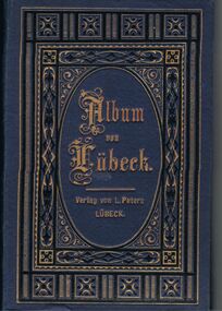 Bendigo Historical Society Inc.
Book - GERMAN HERITAGE SOCIETY COLLECTION: ALBUM VON LUBECK
Item 3. Blue cardboard album with long fold out pages holding 12 photos. The photos are scenic or of buildings of Lubeck. The front cover has a gold and black pattern and the name is imprinted in gold. The photos are numbered. The photos are: 1. Overlooking Lubeck, 2. Lubeck from the Cathedral Tower, 3, Lubeck Harbour, 4. Market Square, Lubeck, 5. Holsten Gates: St Mary's Church; St Peter's Church, 6. Holy Ghost Hospital, Lubeck, 7. Cathedral, Lubeck, 8. Broad Street and Town Hall, Lubeck, 9. Burg Gates, Lubeck, 10. Holsten Gates, Lubeck, 11. St Jacob's Church, Lubeck, 12. Interior of St Mary's Church, Lubeck.L Petersbooks, collections, buildings of lubeck, german heritage society collection - album von lubeck, l peters -
 Glen Eira Historical Society
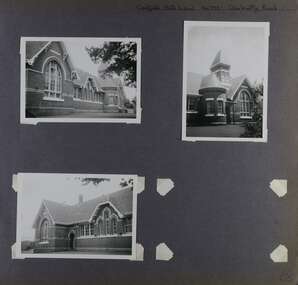
Album - Album page, Caulfield State School, No 773, Glen Huntly Road, Circa 1972
This photograph is part of the Caulfield Historical Album 1972. This album was created in approximately 1972 as part of a project by the Caulfield Historical Society to assist in identifying buildings worthy of preservation. The album is related to a Survey the Caulfield Historical Society developed in collaboration with the National Trust of Australia (Victoria) and Caulfield City Council to identify historic buildings within the City of Caulfield that warranted the protection of a National Trust Classification. Principal photographer thought to be Trevor Hart, member of Caulfield Historical Society. Most photographs were taken between 1966-1972 with a small number of photographs being older and from unknown sources. All photographs are black and white except where stated, with 386 photographs over 198 pages.From: Glen Eira Heritage Management Plan (1996) by Andrew Ward and Associates Caulfield State School No. 773 is important at the State level as the first of similar designs for small schools prepared by the Education Department under H.R. Bastow at Little Bendigo (1878), Glen Waverley (1880), Ascot (1882), Sandringham (1885) and Carlsrich (1892)·. It is a representative example of the Department's Gothic Revival designs, distinguished, however, by the semicircular treatment of the master's office, which compares with Portland (1879), Queensberry St Carlton (1880) and Footscray (1881). It has local significance as the earliest surviving Government School in Caulfield and as a centre for education from 1877, comparing with St. Mary's Jubilee School (qv) of 1887. The Caulfield State School of 1877, the horse tramway of 1889 and subsequently the electric trams were all events confirming the importance of Glenhuntly Road and the fledgling community of "Camden Town" wherein the City's commercial centre has its origins.Page 68 of Photograph Album with three exterior photographs (two portrait and one landscape) of one side of Caulfield State School with a fourth photo missing from the page.Hand written: Caulfield State School No. 773 Glenhuntly Road [top right] / 68 [bottom right] trevor hart, glen huntly road, caulfield state school, caulfield primary school, gothic revival, schools, caulfield south, arched window, tower, 1870's, camden town, red brick, curved windows, terracotta tiles, master's office, education, primary school, glenhuntly road, h r bastow -
 Glen Eira Historical Society
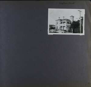
Album - Album page, Hopetoun Street, Circa 1972
This photograph is part of the Caulfield Historical Album 1972. This album was created in approximately 1972 as part of a project by the Caulfield Historical Society to assist in identifying buildings worthy of preservation. The album is related to a Survey the Caulfield Historical Society developed in collaboration with the National Trust of Australia (Victoria) and Caulfield City Council to identify historic buildings within the City of Caulfield that warranted the protection of a National Trust Classification. Principal photographer thought to be Trevor Hart, member of Caulfield Historical Society. Most photographs were taken between 1966-1972 with a small number of photographs being older and from unknown sources. All photographs are black and white except where stated, with 386 photographs over 198 pages.HO35 Hopetoun Private Hospital, Part of 2 - 6 Hopetoun Street in the City of Glen Eira From Victorian Heritage Database citation for Hopetoun Private Hospital https://vhd.heritagecouncil.vic.gov.au/places/43647 as at (21/10/2020) "Melrose" is of regional importance as a surviving and substantially intact example of a large villa residence designed by the noted Melbourne architect, Charles Webb. Its importance is enhanced by the use of unusually fine cast iron balustrading. As a surviving large villa designed by Charles Webb, it compares with his own home "Farleigh" (1865), in Brighton whilst the tower compares with his first home "Chilton" (c.l853)Page 88 of Photograph Album with one landscape photograph of a double storey mansion.Handwritten: Hopetoun Street [top right] / 88 [bottom left]trevor hart, elsternwick, hopetoun street, melrose, hospital, private hospital, victorian, charles webb, cast iron lacework, villa residence, tower, verandah, cars, curved windows, balcony, decorative brackets, cast iron work, mansions, architects -
 Eltham District Historical Society Inc
Photograph, Entrance to Shire of Eltham Memorial Park, Garden Hill, Eltham-Yarra Glen Road, Kangaroo Ground, c.1923
View to south-east from Shire of Eltham Soldiers' Memorial Park showing the carriageway from the road to top of Memorial Park. Accompanying notes state that the entry gate was put in place in May 1921. Eltham and Whittlesea Shire Advertiser and Diamond Creek Valley Advocate Fri 21 May 1920 p 2 reported: Kangaroo Ground Memorial Park "It was decided to arrange for a working bee on Saturday, 29th inst., for the purpose of forming and gravelling the track leading to the Park, and of carrying out other necessary works." A history summary of the Shire of Eltham Soldiers’ Memorial Park • The summit at Garden Hill was a popular tourist lookout and picnic spot from the 1880s. Virtually the entire Shire of Eltham and beyond could be viewed from this location. • A local farmer, Mr Walter A. D. Wippell is credited as being the first to propose the idea of a war memorial park and offered £50 towards the purchase of the land. • The earliest public reference to this project is to be found in the local Advertiser newspaper edition of August 9th, 1918. A report of the August Council meeting records the Eltham Shire President, Cr. Robert White, saying: "some time back it was proposed that the Council obtain and place on an Honour Board in the Council Chamber [at Kangaroo Ground] containing names of the lads who had enlisted. Just recently however, it had been suggested that a more fitting memorial would be the obtaining of a piece of land on the summit of Garden Hill, Kangaroo Ground, and the formation of a memorial park in which a monument could be erected to represent the whole of Shire. If a couple of acres could be obtained a gentleman had promised to donate 50 pounds, and another one would fence it, and other contributions, he was sure, could be obtained." • Councillors were favourable of the proposal and the President, Shire Secretary and Shire Engineer were deputised to wait on Messrs Mess Bros. (the owners of the Garden Hill farm) and ascertain if they would gratuitously give the land. The Mess Bros. land adjoined the farm/stud of Mrs Fanny White (Cr Robert White’s mother), daughter of Andrew Harkness who established their property on Garden Hill around 1846. • Access to the land came in February 1919 when several Councillors and the Shire Engineer surveyed the actual two acres of '5 chains along the road and 4 chains deep'. The Engineer volunteered his services free to do this task. The Mess brothers however demanded £100 per acre but eventually agreed to take £50 per acre. • Entry from the Kangaroo Ground-Yarra Glen road was seen to be a problem and Mrs. White, who owned the land beside the park, was asked to donated a triangle of her property to allow this access. • By September 1919 returned soldiers were employed by the Shire and volunteers were called to clear the hilltop by ploughing up the rocks and clearing the area, the fencing was put into place and in May 1921 the Council erected three gates, within an archway, at the entrance to the drive and pathway to the summit. • Public subscriptions were sought through the Advertiser newspaper to beautify the site. The views of the Curator of the Melbourne Botanical Gardens were sought as to the ‘class of ornamental trees most suitable for planting in the Park area”. • The Memorial Park or Shire of Eltham Soldiers’ Memorial Park was officially opened by Mr. W.H. Everard, M.L.A., 3 September 1921. • In 1922 plans were made to place a War Memorial in the Park. Funds were donated by the Council of £250 and a challenge to the community, to match this money with contributions was met. • On Anzac Day 1923, 1,000 people gathered on the summit in the park for a memorial service. A much smaller group of about 50 people gathered around a newly constructed cairn and flagstaff in the afternoon of Anzac Day 1924 amidst rain and a squally southerly wind, the morning service being cancelled. • A meeting for those interested in establishing a War Memorial monument within the park was held in January 1924 and the Eltham Shire War Memorial League was formed and a design competition decided upon. • The Shire of Eltham War Memorial tower was built in 1926 at a cost of £1,023 and 5 shillings with locally quarried stone donated by Dr Ethel and Professor William Osborne. It was formally known as the ‘Shire of Eltham War Memorial’ and was unveiled on 11 November 1926. The large bronze inscription above the entrance to the tower states: SHIRE OF ELTHAM WAR MEMORIAL THESE MEN DIED FOR THEIR COUNTRY 1914 IN REMEMBRANCE THIS TOWER WAS BUILT 1918 • The Caretaker’s hut was built in 1927 with left over from the tower construction. • A returned soldier was appointed to act as caretaker for the memorials. Tiny Carrol, a huge man, was the first caretaker and lived in the stone hut. There was a push to have alterations made at one stage to provide additional rooms for a married caretaker but was rejected. • A new Caretaker Cottage was built in 1951 at a cost £2,500. The cottage had been subjected to raids by thieves three times during construction until a guard from the Returned Servicemen’s League was posted until its opening. • The War Memorial tower was re-dedicated by Sir Dallas Brooks on 8 November 1951, unveiling new bronze plaques containing the names of those who fell during the Second World War. Sir Dallas also officiated the opening of the new Caretaker’s Cottage. • A toilet block was built in 1965. • A further dedication of the Shire of Eltham War Memorial tower took place 11 November 2001 to recognise the men who fell in subsequent campaigns up to and including Vietnam. • Four land titles are involved: o The purchase of the two acres from owners Ruth Gosling, Alexander Mess, James Johnson Mess and Joseph Mess is recorded in two actions, the first being the payment of £100 for the two acres, the second showing that the Shire of Eltham did not get a transfer of title until 14th January 1952. o The access land donated by Mrs. Fanny White is dated 26 February 1924. A further need to widen the entry came after the deepening of the road cutting and another land donation was given by Sir Herbert Gepp, title dated 15th May 1952. This would have been about the time he sold off the former White ‘Garden Hill’ property. o The land reserve to increase the area and possibly allow a circuit road to be put in place on the western side of the park was purchased by the Shire of Eltham, title dated 16th February 1973. Rare photograph of the entrance to the Shire's Memorial Park during early stages of development prior to the erection of the Shire of Eltham War MemorialSepia photograph printed with white border with slight crack lower left hand corner and three significant vertical cracks fanning from lower centre edge to upper edge Digitally enhanced version to minimise impact of crackseltham-yarra glen road, entrance gate, garden hill, kangaroo ground, shire of eltham memorial park, shire of eltham war memorial, kangaroo ground war memorial park -
 Ringwood and District Historical Society
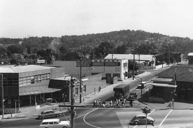
Photograph, Ringwood Street at corner of Maroondah Highway Ringwood - 1969
Black and white photograph of Ringwood St. at corner of Maroondah Highway, 1969. Old post office on right and Loughnans Hill in background. (2 images)Written on back of one photograph (MHW 52): "Dec 1969, Ringwood Street. Taken from clock tower. Old P.O. on right corner. New P.O. occupies vacant block in Ringwood Street." Typed under second photograph (MHW 52a): "Ringwood St at cnr of Maroondah Hwy, 1969. Old Post Office on right and Loughnans Hill in background. The vacant block on Ringwood St can be seen where our 4th Post Office now stands. Old telephone exchange and site of new one can be seen at corner of Charter St. Dec 1969." -
 Bendigo Historical Society Inc.
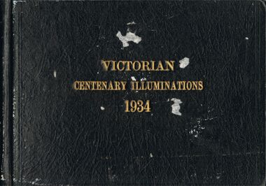
Photograph - VICTORIAN CENTENARY ILLUMINATIONS 1934
Photo album, brown hard cover, writing in gold leaf ' Victorian Centenary Illuminations 1934' Contains black and white images of Melbourne, taken at night. Includes, south bank of Yarra, Princes Bridge, Collins Street, Flinders Street, Elizabeth Street, Shrine of Remembrance, St. Kilda, Swanston Street, Hawthorn War Memorial, State Electricity Commission Head Office, Electricity supply Building, Electricity Commission and Port Authority buildings, South Melbourne Town hall, Hotel Windsor, Parliament House, Town hall, Fire Brigade building, State Savings Bank, National Bank, Melbourne town hall, Bank of Australia, Port Authority Building, Steam Tower. All the photographs in this album pertain to the City of Melbourne, and have NOT been scanned.cottage, miners, melbourne, melbourne, centenary -
 Bendigo Historical Society Inc.
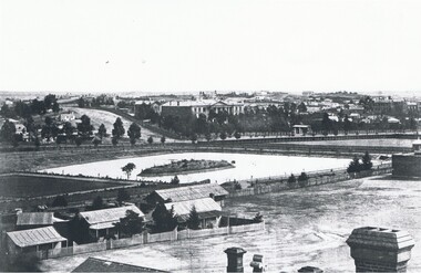
Photograph - LANDSCAPE VIEW OF BENDIGO
Black and white photograph. In foreground, roof and chimneys. Row of 3 small weatherboard houses with verandah, picket fences. 1 small and 1 larger building behind. Lake or dam with small island centre, stone brick wall with lookout tower at corner ( Bendigo gaol ) at right centre distanc,e large building. Benevolent Asylum. Many other buildings in distance. James Lerk 11.2.2000 ' view from the Corporate High School, Benevolent Asylum in centre' Unknown BHS member 5.11.1999 ' lower dam ( site of present tennis courts, Park Road, pumped out C 1926' Written on back of photo 'Bendigo Victoria 1860's, Sandhurst North view 100 miles north from Melbourne. C. Nettleton, Victorian Views'C. Nettleton ?place, landscape view, bendigo -
 Bendigo Historical Society Inc.
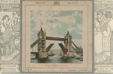
Postcard - GLADYS DEAN COLLECTION: POSTCARD, 1906 - 1908
Postcard with raised 8.5cm x 8.5cm coloured silk image of Tower Bridge London. Image has printed words 'Patent' and 'Fab Card' either side of a printed coat of arms at the top and letters W.N.S.B. bottom left corner and 'Series V No 40' bottom right corner. Image is attached to printed 14cm x 9cm black and white printed card. The words 'Fab Card' and 'The Art Patchwork Series' appear on the card either side of the image. Printed drawings of 1. two women, one seated sewing and one standing sewing and 2. two women standing examining a cloth, appear either side of the image. On reverse card is addressed to Miss G Dean McKenzie St Golden Square Victoria Australia.W N Sharpe Sole Publisher Bradfordpostcard -
 Bendigo Historical Society Inc.
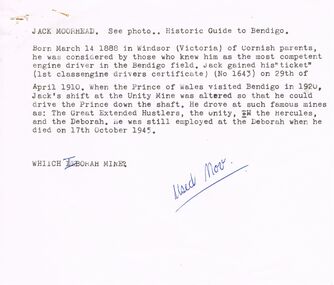
Document - VARIOUS ARTICLES FOR NEWSLETTER ('MARUNARI?) FOR NOVEMBER
Various articles for Newsletter ('Marunari??) for November???? 1. Re Jack Moorhead (''the most competent engine driver in the Bendigo field'') with handwritten copy of same; 2. 3 pages of handwritten notes for inclusion in the newsletter - various topics; 3. ''The Canons (sic) on Camp Hill'' - history of the Lookout Tower site and flag post, cannons and statue - semi-nude lady - which was damaged in storm and later removed. Source of information for this item attributed to Misses D and D Davenpor, London and the Bendigo Advertiser; handwritten notes re this same article. 4. ''Boys will be boys'' by Mr A Richardson - article based on Annual Report of the Secretary for Mines and Water Supply, 1885 re 11 year old lad who fell down mine; handwritten notes on same article.document, names of bendigo pioneers, jack moorhead.