Showing 12613 items matching " development"
-
 Eltham District Historical Society Inc
Document - Folder, Eltham Cemetery, Mt Pleasant Road, Eltham, Vic, 2009-2010
Initially collated by Harry Gilham regarding the history of the cemetery and various developments and artworksarthur munday, cemetery gates, chappel terrace, eltham cemetery, gravedigger, james orford, justus jorgensen, lena cooper skipper, lily agnes jorgensen, mervyn g. skipper, svend erik kroyer-pedersen, vaults -
 Greensborough Historical Society
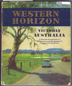
Book, Australian Publicity Council, The Western horizon of Victoria Australia, 1960c
A glossy publicity publication for the state of Victoria.111 p., illus. (some col.), maps.non-fictionA glossy publicity publication for the state of Victoria.victoria - history, western district (vic.), melbourne - history -
 Greensborough Historical Society
Newspaper Clipping, Traffic a concern, 19/03/2014
Concerns are raised over the 38-apartment development at 4 Poulter Avenue Greensborough.News clipping, black text.poulter avenue greensborough, michael karagiannis, land development -
 Greensborough Historical Society
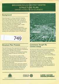
Pamphlet, Shire of Diamond Valley, Greensborough District Centre, Structure Plan, 1988_
This was issued in 1988 calling for comments regarding the proposed development of the Greensborough Centre in 1988.This pamphlet has pictures of Greensborough as it was in 1988 and 4 concept plans for the proposed development.A 6 page folded pamphlet with green print on a glossy yellow paper.Nilgreensborough centre, 1988, diamond valley shire, lend lease -
 Greensborough Historical Society
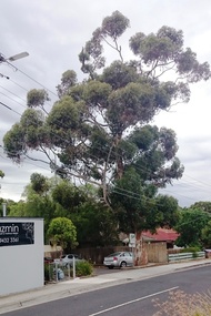
Photograph - Digital image, Marilyn Smith, Tree, Poulter Avenue and Main Street, 20/10/2016
This established tree in Poulter Avenue Greensborough is at risk from development of the surrounding properties.Established trees such as this have been removed as the area is developed.Digital copy of 3 colour photographspoulter avenue greensborough -
 Greensborough Historical Society
Newspaper Clipping, Herald Sun, Estate offers buyers a fair deal, 24/04/2010
This article advertises a new residential development "Fairview" in Bridge Inn Road Mernda.News clipping, text and colour image.mernda, bridge inn road mernda -
 Eltham District Historical Society Inc
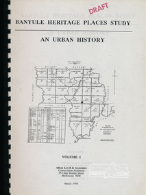
Book, Banyule City Council, Banyule Heritage Places Study - An Urban History, Volume 1 prepared by Allom Lovell & Associates, 1998 March
Describes the broad patterns of development across Banyule in the post-European contact period, 92 p, 30 cmbanyule history, greensborough history, montmorency history, heidelberg history, ivanhoe history -
 Moorabbin Air Museum
Document (item) - Commonwealth Aircraft Corporation Technical Order CAC Avon Sabre Mk30 Mk31 Mk32 modifications Mod. No
Development of the CAC Sabre Mk.30 Mk.31 Mk.32 ModificationsHandwritten notes on the envelopes with the modification number -
 Geelong Cycling Club
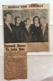
GACC Club Records
Information provided regarding the formation and development of GACC over the period 1926 to 1960s.Points to the importance of cycling in the community during this period.GACC Club Records 1926-1970, including formation of GACC 1926. Newspaper articles including proposed Belmont Common Velodrome 1960s and farewell to John Hine.john hyne; gacc; club records; -
Tatura Irrigation & Wartime Camps Museum
Book, Caniambo-Gowangardie-Tamleugh, 1985
Written to record the history and development of 3 neighbouring district in North East Victoria.Brown cover, white writing. 3 sketches of old buildings in green on front cover. Designed by Ian Cole. 131 pages.rural victoria, caniambo, gowangardie, tamleugh, victorian towns -
 Robin Boyd Foundation
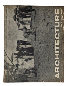
Journal, RAIA, Architecture in Australia, Vol. 48, No.4, Dec-59
This issue is devoted to Canberra - the development of Canberra, the existing city, the next stage and an editorial.architecture, australian architecture, walsh st library -
 Peterborough History Group
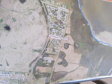
Plan - Moyne Shire Council Aerial photograph, Department of Sustainability and Environment, January 2018
View shows development at the time and showing the town boundary using Vicmap InformationSignificant in that it provides a record of the current state of development of the town. Also, a view of the estuary at that time.A3 size copy of an aerial view of the majority of the town with street names mentioned. curdies river inlet, peterborough, aerial view -
Peterborough History Group
Peterborough Foreshore Committee Records
Records about the running of the Foreshore Reserve, including the playground and the development of the Caravan Park.Significant as it includes information about the establishment, maintenance and running of the caravan park, including a list of names of bookings in 1958. Also information about the construction of the river boat ramp and the town playground. Correspondence about a request by the Foreshore Committee to include land to the west of Peterborough but which was subsequently adopted by National Parks. It is interesting to note the names of Committee members and the changes over time. Storage box containing various documents pertaining to the running of the Foreshore Committee including cheque book, copies of correspondence, receipts and financial records.peterborough, great ocean road, camping, curdies river -
National Wool Museum
Book, The Manufacture of Wool Carpets
"The Manufacture of Wool Carpets" International Wool Secretariat Development Centre, Ilkley, 1984..sheep - new zealand, international wool secretariat, carpet -
Moorabbin Air Museum
Document (Item) - Draft of Speech Regarding the Potential of Aviation Developments in the 1970s, Speakers Notes
The speech, drafted in January 1968, was looking forward to the 1970s as a decade of "exciting developments" -
 Whitehorse Historical Society Inc.
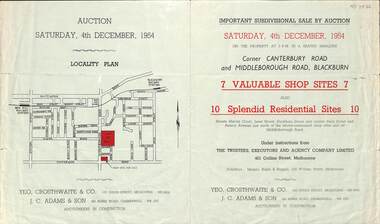
Pamphlet - Auction Flyer, Yeo, Crosthwaite & Co, Corner Canterbury Road and Middleborough Road, 4th December 1954
A green folded pamphlet advertising the sale of by auction of a shop and residential sites on the corner of Canterbury and Middleborough Roads, Blackburn on Saturday, 4 December 1954.A green folded pamphlet advertising the sale of by auction of a shop and residential sites on the corner of Canterbury and Middleborough Roads, Blackburn on Saturday, 4 December 1954.non-fictionA green folded pamphlet advertising the sale of by auction of a shop and residential sites on the corner of Canterbury and Middleborough Roads, Blackburn on Saturday, 4 December 1954.canterbury road blackburn, beck street, middleborough road blackburn, marion court, amery avenue, janet street, duckham street -
 Lakes Entrance Historical Society
Photograph - Bairnsdale Methodist church and hall Bairnsdale Victoria, K Scarce, 1989
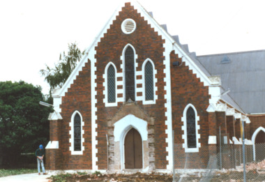
Sold for site development after amalgamation of Methodist and Presbyterian to become Uniting Church Colour photograph taken at start of demolition of Bairnsdale Methodist church and hall Service Street Bairnsdale Victoria. Also two colour photographs at various stages of demolition. historic buildings -
 Kiewa Valley Historical Society
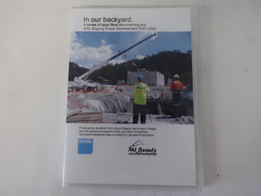
DVD - AGL Bogong Power Development & 6 DVDs with students contributions, In Our Backyard
Students from Mt Beauty Secondary College produced this set of 3 DVDs re the development of AGL's Bogong Power Development 2007-2009. This was an addition to the Kiewa Hydro Electric Scheme built by the SECV in the 1950s. The information covers many aspects of the Development which is of interest as well as being educational for the students. The request re the SECV Adit Shaft was to assist with the information board beside the shaft on the Gorges Walk on the West Kiewa River. DVDs were a digital means of passing on information to an audience and enabled multiple copies to be made. The Kiewa Hydro Electric Scheme is in the Kiewa Valley producing clean energy for Victoria. The Bogong Power Development increased the production of electricity in line with more clean energy and gave locals employment and students an insight into its construction and issues. The technical aspect of using DVDs to present this knowledge was also part of the education for the local students. x3 DVDs with hard clear plastic box cover. The cover has a photo on the front with the title typed above it and production details below along with the AGL logo and its Mt Beauty logo.On the back the details (title and content) for each of the 3 DVDs is given. DVD Stories: 1, 2, 4, 7 & 8 and DVD "AGL Photos West Kiewa - In response to letter re photos of Adit Shaft. July 2013"bogong power development project, mt beauty secondary college 2007-2009, agl -
 Kew Historical Society Inc
Plan, Melbourne & Metropolitan Board of Works : Borough of Kew : Detail Plan No.1590, 1905
The Melbourne and Metropolitan Board of Works (MMBW) plans were produced from the 1890s to the 1950s. They were crucial to the design and development of Melbourne's sewerage and drainage system. The plans, at a scale of 40 feet to 1 inch (1:480), provide a detailed historical record of Melbourne streetscapes and environmental features. Each plan covers one or two street blocks (roughly six streets), showing details of buildings, including garden layouts and ownership boundaries, and features such as laneways, drains, bridges, parks, municipal boundaries and other prominent landmarks as they existed at the time each plan was produced. (Source: State Library of Victoria)This plan forms part of a large group of MMBW plans and maps that was donated to the Society by the Mr Poulter, City Engineer of the City of Kew in 1989. Within this collection, thirty-five hand-coloured plans, backed with linen, are of statewide significance as they include annotations that provide details of construction materials used in buildings in the first decade of the 20th century as well as additional information about land ownership and usage. The copies in the Public Record Office Victoria and the State Library of Victoria are monochrome versions which do not denote building materials so that the maps in this collection are invaluable and unique tools for researchers and heritage consultants. A number of the plans are not held in the collection of the State Library of Victoria so they have the additional attribute of rarity.Original survey plan, issued by the MMBW to a contractor with responsibility for constructing sewers in the area identified on the plan within the Borough of Kew. The plan was at some stage hand-coloured, possibly by the contractor, but more likely by officers working in the Engineering Department of the Borough and later Town, then City of Kew. The hand-coloured sections of buildings on the plan were used to denote masonry or brick constructions (pink), weatherboard constructions (yellow), and public buildings (grey). Surveyed by the Board of Works in 1903 and published in 1904, Plan No.1590 shows development north of Cotham Road. While this plan includes built structures in Mary Street, Cotham Road, High Street, Park Hill Road, Kent Street, Ridgeway Avenue, and Ermington Lane (now Ermington Place), only part of this section was notated and coloured in this contractor’s copy. Numerous houses, large and small are named on the plan: ‘Cholula’, ‘Belper’, ‘The Uplands’, ‘Spring Grove’ facing Cotham Road; ‘Marion’ facing Kent Street; and ‘Kia Ora’ facing Ridgeway Avenue.melbourne and metropolitan board of works, detail plans, mmbw 1590, survey plans - borough of kew, cartography -
 Ringwood and District Historical Society
Newspaper, Scrapbook Clipping, Library Collection, Ringwood, Victoria
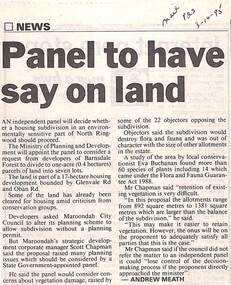
Newspaper Clipping from "The Mail", 3-10-95. P23. By Andrew Meath. Panel to have Say on LandAn independent panel will decide whether a housing subdivision in an environmentally sensitive part of North Ringwood should proceed. The Ministry of Planning and Development will appoint the panel to consider a request from developers of Barnsdale Forest to divide one acre (0.4 hectares) parcels of land into 7 lots -
 Eltham District Historical Society Inc
Photograph, Peter Pidgeon, 22 Luck Street, Eltham, 11 February 2018, 11/2/2018
Development application 252/2017/03P: Use and development of the land for 8 three storey townhouses (revised to 7) Land sold 20 Dec 2107 for $1,515,000 - https://www.realestate.com.au/sold/property-residential+land-vic-eltham-201972410 Previously $140,000 June 1994 and $165,500 Oct 1988 Born digital image (6)eltham, luck street, streets, houses -
 Bendigo Military Museum
Administrative record - International Map of the World (IMW) 1:1 Million Scale - H Ureta, Circa 1964, MR H Ereta, Post 1964
This document records the history of the International Map of the World (IMW) at 1:1Million Scale. Mr H. Ereta, Chief of the Cartographic Section of the United Nations Department of Economic Development and Social Affairs gave a lecture on the IMW and described the history and development of the map series in post 1964. This document is a copy of that lecture. 7 x Foolscap pages of typed text, stapled and two hole punched, Paper is dis-coloured.royal australian survey corps, rasvy, fortuna, army survey regiment, army svy regt, asr, imw -
 Ringwood and District Historical Society
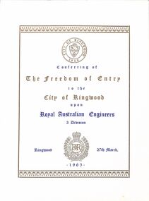
Booklet, Ringwood City Council, City of Ringwood - Freedom of Entry book for Royal Australian Engineers 3 Division, including history of the Division, 1965
Buff coloured book referring to the freedom of entry to the City of Ringwood being granted upon Royal Australian Engineers 3 Division, including how the ceremony originated for granting freedom of entry and order of ceremony.; History of the Royal Australian Engineers 3 Division 1948-1965 and history of the development of Ringwood. -
 Bendigo Historical Society Inc.
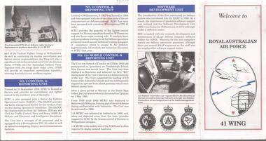
Document - RAAF RADAR REUNION COLLECTION: WELCOME TO ROYAL AUSTRALIAN AIR FORCE 41 WING
Small information booklet titled: Welcome to Royal Australian Air Force 41 Wing, Chapters are The air defence ground environment - No.41 Wing, a brief history - No.2 control and reporting unit - No.3 control and reporting unit - No.114 mobile control and reporting unit - software development unit.military, airforce, raaf radar -
Port Melbourne Historical & Preservation Society
Document - CD-ROM, Albert DAVIES scrapbook, AMS imaging, 1927 - 1932
Original scrapbook was given to Mr Bill PHILLIPS by Mr DAVIES' daughter after the death of her parents. Janet BOLITHO arranged for scanning and CD to be produced, with no restrictions on use.CD containing scans of 135 pages of a scrapbook compiled by Albert (Bert) DAVIES from approximately 1927- 1932. Main topics covered are Port Melbourne Council elections; housing development on Fisherman's Bend; the lagoon infill; Depresion relief; industrial and union issues; and the campaign for an airport on Fisherman's Bendlocal government, fishermans bend, politics, sandridge lagoon, state government victoria, albert (bert) davies, bill phillips, local government - city of port melbourne, depression, societies clubs unions and other organisations, transport - aviation and aerodrome -
Port Melbourne Historical & Preservation Society
Archive - BayLinks, Ian McKAY Archive, 1985 - 1992
These papers document Ian McKAY's involvement in the above. Filed & indexed by J BOLITHO.Ian McKAY key documents and themes - BayLinks, concept plan for Port Phillip Boulevard, info sheet from Swallow & Bain Street Residents Association, material about ESS, Port Melbourne Citizens Action Group, a response to the Bayside Development project, National Trust submissions (1985-92).public action campaigns, local government - city of port melbourne, town planning - proposals shelved - bayside, melbourne harbor trust - port of melbourne authority, ian mckay, janet bolitho -
 Bendigo Historical Society Inc.
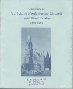
Book - KEN HESSE COLLECTION: CENTENARY OF ST. JOHN'S PRESBYTERIAN CHURCH FOREST STREET, BENDIGO
A small blue soft covered book titled, 'Centenary of St. John's Presbyterian Church Forest Street, Bendigo 1872-1972.' This is an historical record of the establishment and development of the Presbyterian Church in Bendigo. Bendigo, 1972. 24pgs. Item part of the Mr. Ken Hesse Collection donated by Mr. James Lerk.church, history, presbyterian church forest st bendigo, ken hesse collection, collection, bendigo, religions, christianity, organisation, history, st. john's church bendigo, presbyterian church -
 Bendigo Historical Society Inc.
Document - LA TROBE UNIVERSITY BENDIGO COLLECTION: BENDIGO TEACHERS' COLLEGE HISTORY
Two typed sets of notes 'Bendigo Teachers' College 1926-1931' and 'A Chronological History of the development of Bendigo Teachers' College.' These notes are part of Ms. J.C. Burnett's collection in her preparation for her book 'History of Bendigo Teachers' College, 1926-1973.' This book was published by Cambridge Press in 1973.bendigo, education, bendigo teachers' college history, la trobe university bendigo collection, collection, bendigo, education, tertiary education, history, bendigo teachers' college, ms. j.c. burnett, book, history of bendigo teachers' college 1926-1973, teacher training -
 Bendigo Historical Society Inc.
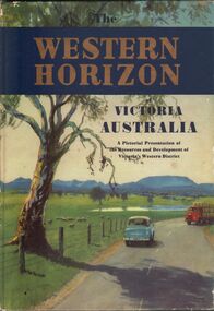
Book - AILEEN AND JOHN ELLISON COLLECTION: THE WESTERN HORIZON
The Western Horizon of Victoria Australia. A pictorial presentation of the resources and development of Victoria's western district. Australian publicity council, 405 Collins Street, Melbourne. The book has 112 pages. On the inside title a dedication: to Brian with best wishes for your 17th birthday from the Rogers, 22/05/59.books, atlases, western victoria -
 Ballarat Tramway Museum
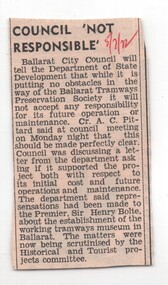
Newspaper, The Courier Ballarat, 'Council not responsible', 5/07/1972 12:00:00 AM
Newspaper clipping from The Courier, Ballarat, 5/7/1972, about the Ballaarat City Council telling the Department of State Development, that while it is putting no obstacles in the way of the BTPS, it will not accept any responsibility for its future operation or maintenance. Mentions Cr. A Pittard, the Historical and Tourist Projects Committee of Council.In red ink top right hand corner '5/7/72'trams, tramways, city of ballaarat, museum establishment, a. pittard