Showing 2360 items
matching orchards
-
 Ballarat Tramway Museum
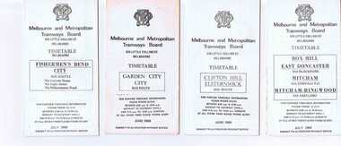
Ephemera - Timetable/s, Melbourne and Metropolitan Tramways Board (MMTB), Set of 14 MMTB Melbourne bus timetables, 1969
Set of 14 MMTB timetables for various bus routes, dated July 1969. Generally includes Sat and Suns, Good Friday and Christmas day as well as weekdays, unless noted otherwise. Also includes a map of the route, detailed time points, sections, connecting services, fares, and organisation address - 616 Little Collins St. Melbourne. Have been folded into eight or ten portions. All on white paper unless noted otherwise. Items shown with an # - have a sticker modifying timetable information details on the front page. Items shown with a % are larger size sheets of paper, folded into 10. 1155.1 - Clifton Hill - Elsternwick # .2 - Garden City - City # .3 - Fishermen's Bend - City .4 - Box Hill - East Doncaster via Blackburn, Mitcham via Donvale PO and Mitcham - Ringwood via Eastland .5 - Warrandyte via Templestowe, via East Doncaster, Donvale PO - City % .6 - Warrandyte, Park Orchards Ringwood .7 - Williamstown Rd., Footscray Railway Station, Ballarat Rd # .8 - Latrobe University, Northland, West Heidelberg - City # % .9 - Deer Park, Sunshine Park, Sunshine, Footscray - City # .10 - as above, but for Saturdays and Sundays on pink paper # .11 - Box Hill, Heidelberg, Templestowe .12 - Box Hill, North Blackburn .13 - East Kew, Box Hill, Doncaster .14 - Bullen, North Kew - City # % Images of a sample of documents added 16-11-2013. mmtb, timetables, melbourne -
 Eltham District Historical Society Inc
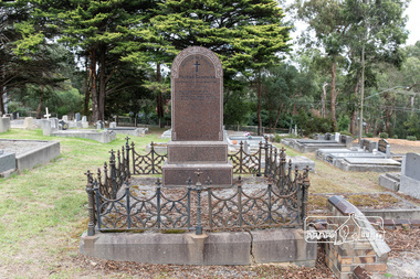
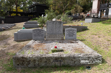
Photograph, Peter Pidgeon, Grave of John and Mary Murray, Eltham Cemetery, Victoria, 5 April 2021
Irish-born John Murray and his wife Mary (daughter of Thomas Sweeney) married in 1849 and settled in Eltham North. John and Mary were amongst the earliest inhabitants of Eltham. John was a farmer and their block of about 80 acres, called ‘Laurel Hill’, was on the eastern side of the Diamond Creek, extending east to beyond Zig Zag Road. It was later extended southward by the purchase of a further 60 acres. He is recorded as a supporter on the petition for a school in Eltham and he served on the National School Board of the Eltham school. John died in 1867 and is buried in Eltham Cemetery with Mary and with two of their grandchildren. Their eldest son Johnnie inherited the property. Then in about 1902 his younger brother James purchased about 50 acres on the western side of the Diamond Creek immediately opposite Laurel Hill, extending west to slightly past Wattletree Road. Eltham North Reserve now lies just beyond the southern boundary. James built a family home on top of the hill on the northern boundary, together with a dairy and milking shed and a food cellar. It is thought that the barn with stables was already there. When Johnnie died in 1912, the two properties (though severed by both the creek and the railway line) effectively merged. The land was worked as an orchard with apples, pears, quinces, and possibly apricots and peaches. Later it became a dairy farm. By 1986, almost all the land had been sold off for residential subdivision and the house had been condemned as unfit for habitation. John's grandson Jim retained a small portion of the land and built a new house. He kept the old one as a storage shed, but it was demolished after he died in 1993. The very old barn is still standing. Located in the Roman Catholic section In Memory of John Murray Who died Dec. 1867 aged 50 years Also his wife Mary Murray Who died 7th Sep. 1909 aged 76 years And of their grandchildren Thomas and Mary Ellen DrainBorn Digitaleltham cemetery, gravestones, john murray, mary ellen drain, mary murray, thomas drain -
 Eltham District Historical Society Inc
Photograph, Fay Bridge, Ruins beside the Diamond Creek at Wattle Glen, 13 October 2016
The newly constructed Diamond Creek Trail from Diamond Creek to Wattle Glen completed in February 2021 winds around these ruins just pass the high transmission power lines near Herberts Lane and Collard Drive From Jean Verso, Nillumbik Historical Society, 15 April 2021 William Wandless Herbert bought the surrounding 100 acres in 1852. He was a native of Northumberland and the Scottish Borders who arrived in Melbourne in 1847. The house on the top of the mound would have been built not long after he bought the land; the farm was named "Greenhills". He married Elizabeth Wilson, daughter of John Wilson who had been in Diamond Creek since about 1846. Their first child was born in 1854 so there would be some form of dwelling from about that time. They had eight children who all survived to a good age. His will describes the house as part stone and part wood and of four rooms. Nillumbik Historical Society (NHS) believe it was one of the earliest if not the earliest house, in this part of the district. The remains of the stone house foundations are on top of the mound (photos on the VHD page) and the barn walls are on the north and to the east side of the mound. NHS is not sure how much or which part of the surrounding area was covered by the barns but they were large enough to hold dances after the race meetings that were held in the late 1880's on the adjacent creek flats. It would make sense with the lay of the land that they covered some of the ground to the north and east and used for farm storage, packing sheds for their apple and pear orchards and also for supporting the Nillumbik Gold Mine the family worked to the north up the gully. The path that comes down the gully and runs into the trail goes past the mine site which was on the west side of the gully a couple of hundred metres up from the flats. Heritage Victoria link for the site - https://vhd.heritagecouncil.vic.gov.au/places/12203fay bridge collection, 2016-10-13, diamond creek, diamond creek trail, ruins, wattle glen, william wandless herbert, greenhills, elizabeth wilson -
 Eltham District Historical Society Inc
Photograph, Eltham Christian School, severely damaged by a deliberate fire, 10 October 1989, 1989
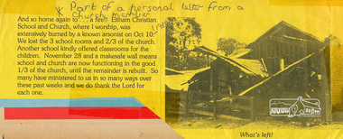
Part of a personal letter from a church member printed on yellow paper with a black and white photograph. Transcription: "And so home again to .. a fire!! Eltham Christina School and Church, where I worship was extensively burned by a known arsonist on Oct 10 (1998). We lost tthe 3 school rooms and 2/3 of the church. Another school kindly offered classrooms for the children. November 28 and a makesafe wall means school and church are now functioning in the good 1/3 of the church, until the remainder is rebuilt. So many have ministered to us in so many ways over these past weeks and we do thank the Lord for each one." The Stokes family settled in this area of Eltham in the 1940s and were associated with the Eltham Christian Church. In the 1970s this church had met in temporary premises in Eltham. Lots of the original 1920s subdivision remained south of Nyora Road and a number of these lots were utilized for the Eltham Christian School, which was established by the Eltham Christian Church in 1981. The school operated on this site until 2000. The premises were owned by the Nillumbik Community Church who were in operation till November 2010 when the Eltham Baptist Church commenced a lease arrangement until the site was purchased by them in April 2012. The building is constructed of brick and timber with a balcony on two sides that looks over an expanse of grass. Sources: STOKES ORCHARD – AN INCOMPLETE HISTORY February 28, 2015 http://www.elthamhistory.org.au/ Australian Christian Church Histories - Eltham Baptist Church http://www.churchhistories.net.au/church-catalog/eltham-vic-baptist/ From a magnetic spiral bound photo album featuring a series of photographs (some cropped) with captions relating to the staff, students and activities of the Eltham Christian School which operated as part of the Eltham Christian Church at Nyora Road, Eltham. See also entries for each photograph.Typed letter printed on yellow paper with a black and white photographeltham christian school, nyora road, fire damage -
 Surrey Hills Historical Society Collection
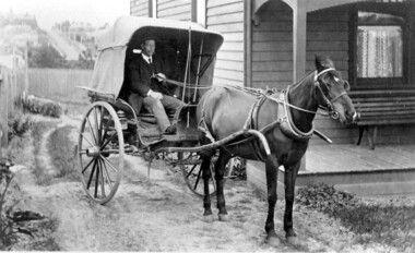
Photograph, Horse and buggy at 44 Guildford Road Surrey Hills, 1913
Jocelyn Hall indicated in notes that the gentleman could possibly be an estate agent. This was confirmed by a grandson of the original owners. (REF: Email 1/8/2020) The original photos is thought to have been a publicity photo for the real estate agency. Carl Theodore Offszanka (1874-1944) was born in Germany. He is listed in electoral rolls at 44 Guildford Road from 1915, occupation furrier, with his wife Ida (nee Schade, 1882-1963), also born in Germany. They were married in Victoria in 1908. In later electoral rolls at the same address are Erna Helena (b 1913; d 1996) and Maria Eliese (b 1910; m Benedict Francis Rieusset in 1936). Both daughters are listed as typists. Also listed is Bernard George (b 1914; d 1987) who in later electoral rolls is described as a process worker. He served in the AIF in the Second World War. Not listed is Carl Bernard b 1909. The Offszanka family lived at 44 Guildford Road from 1913 until post-1980; they came to Surrey Hills from Richmond. Their home was called 'Westfalia' (ref: 1919 electoral roll), presumably after the region in NW Germany. It is not known when Carl and Ida migrated from Germany. This home has had a 2nd storey added to it in late 1990s. According to a family descendant (REF: Email 1/8/20 from grandson) Carl Theodor Offszanka purchased the home in 1913 for £616. He also purchased the adjoining vacant block of land at 42 Guildford Road and ran a large orchard on it before later selling it. This appears to have been between 1920-1930. The family continued to occupy the house until after 1980 when Erna Helena and Bernard George are listed in the electoral rolls. Our property register lists Erna Helena Offszanka as the last member there. She died on 5 May 1996. The Offszanka family occupied this home from its beginning for over 70 years. Such long-term occupancy by one family is unusual.Black and white photo of a ? dark-stained timber Edwardian home at 44 Guildford Road, Surrey Hills. A hooded buggy is located in the rough driveway at the side of the house. A gentleman in a hat and with a moustache is seated in the buggy. A tall building can be seen in the far distance and a street leading up the hill from Canterbury Road.edwardian style, houses, guildford road, horse drawn vehicle, carl theordore offszanka, miss ida schade, mrs ida offszanka, miss edna helena offszanka, miss marie elsie offszanka, mr bernard george offszanka, estate agent, mr carl bernard offszanka, westfalia -
 Wooragee Landcare Group
Photograph, 5 September 2004
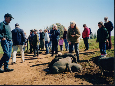
This photograph was taken at Samaria Farm on Sunday the 5th of September when Wooragee Landcare Group took a bus trip to the Tatong area (near Benalla) to look at land use on small farms. The day trip was organised to observe land use on small farms as well as a social event for the Group. Samaria Farm at the time was a nine-hectare property located in northeast Victoria, near Mount Samaria, 130 km Northeast of Melbourne. The photograph features several pigs believed to be the breed called Large Black. The Large Black Pig breed is a traditional, heritage breed that was first imported to Australia from the UK in the early 1900's. It is believed to have originated from the Old English Hog of the 16th and 17th Centuries. The first reference to them in the Australian Pure Bred Pig Herd Book was in 1912. They are a black pig with lop ears and were prized for their superior milking and mothering abilities and soon became popular with early Dairy Farmers who fed them whey from separated milk as part of their butter making process. They proved economical to keep and, being excellent grazing pigs, were also used to pick up windfall fruit in orchards. Their black colouring also enabled them to withstand the hot Australian summers and avoid sunburn which combined with their hardiness and docile temperament made them highly suitable for free-range pork production, however Large Black pigs tend to get very fat and were not suitable for intensive farming so were often crossed with other breeds for pork production. They are now quite rare as a pure breed having been on the edge of extinction for some time. They were rescued in the early 1990s by a rare breeds farmer in the Yarra Ranges. These days they are also the focus of a small conversation effort with six registered breeders currently in Australia. For biosecurity reasons there are no imports of live pigs or pig semen permitted into Australia. This photograph shows a group of people attending one of the events that Wooragee Landcare Group has organized within the educational framework of promoting best land management practices for all types of land uses and ensuring sustainability, in addition to encouraging community interaction via social events. The Large Black pig breed is significant because of their role in early Victorian farming. They are now quite rare as a pure breed having been on the edge of extinction for some time. These days they are the focus of a small conversation effort with six registered breeders currently in Australia. For biosecurity reasons there are no imports of live pigs or pig semen permitted into Australia. Wooragee Landcare Group is important to local community landcare and environmental management practices.Colour rectangular photograph printed on paperObverse: WAN NA EONA2N2. ANN+ 3 4240/ (No. 17) 370samaria farm, wooragee landcare, wooragee landcare group, tatong, benalla, black pigs, large black, traditional breed, heritage breed, pigs, lop ears, free range pork production, early victorian farming -
 Whitehorse Historical Society Inc.
Book, Vermont and us, 2000
... Orchards ...Vermont resident, Joan Nethercote writes on Vermont, families, life and anecdotes, with photos.Vermont resident, Joan Nethercote writes on Vermont, families, life and anecdotes, with photos.Vermont resident, Joan Nethercote writes on Vermont, families, life and anecdotes, with photos.nethercote, joan, nethercote, viv, livermore family, vermont, ballantyne, janet, winswood, vermont, public utilities, giles family, tilson, clive, tilson, clive (mrs), webster family, mckeon, thomas (rev), mckeon hall, cuttle family, wills family, d'arcy family, sport, schools, churches, transport, orchards, scout groups, world war 1939-1945, st lukes anglican church, vermont -
 Eltham District Historical Society Inc
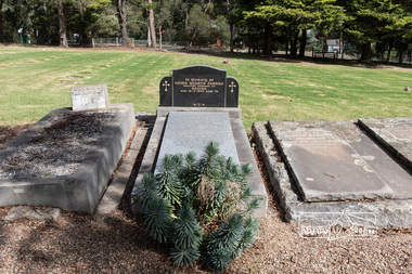
Photograph, Peter Pidgeon, Grave of Patrick Carrucan, Eltham Cemetery, Victoria, 5 April 2021
Whilst the three original Carrucan pioneers and their spouses are all buried at Eltham, only one gravestone (that of Patrick Carrucan) exists. Like many of the poor farmers of these early times, their graves were not marked with any permanent stone monuments and have deteriorated to become unmarked graves over the years. Patrick Carrucan, born in 1831 in Ireland, was the second oldest son of Patrick and Bridget Carrucan. He married Mary O'Brien in Ireland in 1856 before migrating to Australia, accompanied by Mary’s father, to join his sister Bridget Coleman in Eltham who had migrated in 1853. Patrick and Mary purchased a farm at the corner of Dalton and Bible Streets, initially living in a hut. After a few years, a more substantial house was built with assistance from Mary's father, who then returned to Ireland. The farm gradually prospered, with cattle, poultry and an orchard. Patrick and Mary had ten children (Bridget, Michael, Susan, Patrick, Thomas, Mary Anne, Catherine, Margaret, Frances and Annie) and lived in Eltham for the rest of their lives. In later years, the Sweeney and the Carrucan families intermarried, as did most of the old Catholic farming families of the Eltham District. Patrick died 6 October 1894 aged 63, reputedly from a broken back after being run over by his own bullock cart. Mary died in 2 Nov 1927 aged 90. They, together with other family members, are buried in a family plot in Eltham Cemetery, though only Patrick is recorded on the gravestone. Patrick's gravestone was in such disrepair that Betty Erickson (nee Carrucan) paid to have a new one erected in the late 1970s. Unfortunately, this gravestone, like the original, only honours Patrick Carrucan and does not record the other family members buried in this family plot. Betty wrote in 1989 "our people were farmers; the Sweeneys well-educated and prosperous, the Carrucans on a somewhat less favoured scale, but solid workers and providers." Patrick Carrucan Who departed this life 6 Oct. 1894 Aged 63 yearsBorn Digitaleltham cemetery, gravestones, patrick carrucan -
 Eltham District Historical Society Inc
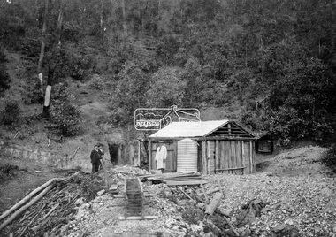
Negative - Photograph, Queenstown (St. Andrews); One Tree Hill Mine, c.1925
L-R: Mr. O. Müller and Mr. John Nink, owners and Mr Müller's son Photograph reproduced on p36 of 'Pioneers & Painters' Gold was discovered on One Tree Hill in 1854. The site has been worked intermittently until fairly recent times (Christmas Hills Past and Present (Yarra Glen & District Historical Society, 2004) ) Advertiser (Hurstbridge, Vic. : 1922 - 1939), Friday 14 November 1930, page 1 ________________________________________ QIJEENSTOWN Death of Mr. John Nink One of the oldest and highly-respected settlers in the person of Mr. John Nink, aged 61 years, passed to his rest on November 10 at his residence, Peach Grove, Queenstown North; after suffering from what is known as miners' complaint. The late Mr. Nink has lived in the district practically all his life and died at the home formerly occupied by his father; Some years ago he conducted a peach orchard, which was one of the sights of Queenstown. He was recently engaged in mining at One Tree Hill with Mr. Otto Muller. He took an active part in public affairs, and was a trustee of the mechanics' institute, recreation ground and cemetery trust. He had a happy disposition, was very hospitable and always merry, which made for him friends all over the district. He leaves a wife, and was the father of Alice (Mrs. Christian), Charles, Robert, William and Minnie (deceased); and the brother of Joseph: (deceased), Henry, Johanna (Mrs. Tonge), Frederick, Mary (Mrs. Antonie) and Robert. His relatives have the sympathy of a large circle of friends in their sad bereavement. The remains of deceased yere interred in Smith's Gully cemetery on Wednesday, and his popularity was shown by the large cortege, amongst the mourners being ex-Cr. Zerbe !(Doncaster), Messrs. Carlyle. Exton, Harris (Kinglake), Birch (Christmas Hills), P. J. McMahon (shire secretary), Crs. Hewitt and Ryan (North Riding), and Cr. D. Murphy (Whittlesea shire). The funeral service was conducted by the Rev. Father Lande (Diamond Creek), and the funeral arrangements were in the hands of Messrs. Apps and Sons.This photo forms part of a collection of photographs gathered by the Shire of Eltham for their centenary project book,"Pioneers and Painters: 100 years of the Shire of Eltham" by Alan Marshall (1971). The collection of over 500 images is held in partnership between Eltham District Historical Society and Yarra Plenty Regional Library (Eltham Library) and is now formally known as the 'The Shire of Eltham Pioneers Photograph Collection.' It is significant in being the first community sourced collection representing the places and people of the Shire's first one hundred years.Digital image (x2) 4 x 5 inch B&W Neg (x2) B&W Print 20 x 25 cm B&W print 9 x 12.5 cmsepp, shire of eltham pioneers photograph collection, queenstown, john nink, o. muller, one tree hill mine, hut, gold mining, one tree hill, goldmining, pioneers and painters, st. andrews, otto johan muller, otto johann müller -
 Kew Historical Society Inc
Plan, Melbourne & Metropolitan Board of Works : Borough of Kew : Detail Plan No.1569, 1905
The Melbourne and Metropolitan Board of Works (MMBW) plans were produced from the 1890s to the 1950s. They were crucial to the design and development of Melbourne's sewerage and drainage system. The plans, at a scale of 40 feet to 1 inch (1:480), provide a detailed historical record of Melbourne streetscapes and environmental features. Each plan covers one or two street blocks (roughly six streets), showing details of buildings, including garden layouts and ownership boundaries, and features such as laneways, drains, bridges, parks, municipal boundaries and other prominent landmarks as they existed at the time each plan was produced. (Source: State Library of Victoria)This plan forms part of a large group of MMBW plans and maps that was donated to the Society by the Mr Poulter, City Engineer of the City of Kew in 1989. Within this collection, thirty-five hand-coloured plans, backed with linen, are of statewide significance as they include annotations that provide details of construction materials used in buildings in the first decade of the 20th century as well as additional information about land ownership and usage. The copies in the Public Record Office Victoria and the State Library of Victoria are monochrome versions which do not denote building materials so that the maps in this collection are invaluable and unique tools for researchers and heritage consultants. A number of the plans are not held in the collection of the State Library of Victoria so they have the additional attribute of rarity.Original survey plan, issued by the MMBW to a contractor with responsibility for constructing sewers in the area identified on the plan within the Borough of Kew. The plan was at some stage hand-coloured, possibly by the contractor, but more likely by officers working in the Engineering Department of the Borough and later Town, then City of Kew. The hand-coloured sections of buildings on the plan were used to denote masonry or brick constructions (pink), weatherboard constructions (yellow), and public buildings (grey). This plan covers parts of Sackville Street, John Street, Thomas Street and Cotham Road, and includes several very large houses in Sackville Street. Job Smith built ‘Berrington’ in about 1888-90 for himself, and ‘Pomeroy’ (now ‘Merridale’) in 1885 for James Mickleburgh. ‘Heathfield’ was built in 1888 for Henry Eeles, and was one of many fine homes in Kew, Hawthorn and surrounding suburbs designed by prolific architect John Beswicke; it later became “La Verna” and was a Franciscan monastery. Similarly, in Cotham Road, we can see ‘Bella Vista’ (now demolished), and ‘Charleville’, with its double-storeyed arcade frontage, built in 1889 for Charles Donaldson whose family occupied it until 1939. This was renamed ‘Ross House’ by the second owner, Dr. Thomas King, and then substantially restored in the 1960s by the Stillwell family, well known as car drivers and dealers. Bella Vista (later ‘Malinda’) was originally designed by the architect Robert Haddon and built for Abel Hoadley, inventor of the Violet Crumble Bar and many other delicious delicacies. He began by manufacturing jams and pickles in South Melbourne using fruit from his own orchard in East Burwood.melbourne and metropolitan board of works, detail plans, mmbw 1569, cartography -
 Glen Eira Historical Society
Album - Album page, Ripponlea, 192 Hotham Street, Circa 1972
... orchards ...This photograph is part of the Caulfield Historical Album 1972. This album was created in approximately 1972 as part of a project by the Caulfield Historical Society to assist in identifying buildings worthy of preservation. The album is related to a Survey the Caulfield Historical Society developed in collaboration with the National Trust of Australia (Victoria) and Caulfield City Council to identify historic buildings within the City of Caulfield that warranted the protection of a National Trust Classification. Principal photographer thought to be Trevor Hart, member of Caulfield Historical Society. Most photographs were taken between 1966-1972 with a small number of photographs being older and from unknown sources. All photographs are black and white except where stated, with 386 photographs over 198 pages.From Victorian Heritage Database citation for Rippon Lea H0614 https://vhd.heritagecouncil.vic.gov.au/places/427(as at 23/10/2020) Rippon Lea was commenced in 1868 by Frederick Sargood, a most successful politician and merchant. He was born in England in 1834 and arrived in Melbourne in 1850. He soon joined his father's wholesale soft goods firm, spending some time as its manager on the goldfields. Sargood entered the Legislative Council in 1874. He was Victoria's first Minister for Defence in 1883. Sir Frederick Sargood was created CMG. In 1885 and KCMG in 1890 as a reward for his contribution to public life. He died suddenly in 1903. Rippon Lea was designed by the leading firm of architects, Reed and Barnes. Joseph Reed had travelled in Europe in 1863, including northern Italy. When he returned he introduced the use of polychromy. While not the first examples, Rippon Lea and the Independent Church in Collins Street were the best and set a fashion which became a distinctly Melbourne style, particularly used for houses and churches. Its popularity was possible because of the new availability of different coloured bricks. Reed's fine Lombardic Romanesque details soon became debased by others. As Sargood's family grew and his fortunes prospered, Rippon Lea was extended to include 33 rooms - a complete mansion. The cast iron porte cochere and the northern conservatory were added in 1897. The architects were Taylor and Fitts. The ballroom was added in 1882 and remodelled in 1889. Many alterations have changed the interior and exterior during the ownerships of Benjamin Nathan and later his daughter Mrs Louisa Jones in the 1930s and are in their own right of significance. Sir Thomas Bent owned the property from 1903 until 1911 but never lived there. He subdivided much of the land. The original garden dates from about 1868, and it seems that William Guilfoyle of the Botanic Gardens was involved. It was redesigned in a more natural style in the 1880s by Sargood and his head gardener, Adam Anderson. The lake, waterfalls, fernery, hill and grotto are balanced by mighty deciduous trees and conifers. These are interspersed with, but never dominated by Australian species such as eucalyptus and other exotics. The sinuous drive with its carefully prepared approach to the house is notable. The original vegetable gardens, orchard and outer paddocks no longer survive. The shade house is important as the largest known in Australia and possibly the world. Its curved plan and form of construction are particularly notable. It was built about 1884.Page 90 of Photograph Album with five photographs (one landscape and 4 portrait) of Ripponlea - two different views of the front entrance to the mansion, one of the front gates and two different views of the main residence.Handwritten: "Ripponlea" 192 Hotham Street [top right] / North [under top left photo] / Neg 255 Dec 1972 MAIN DRIVE [under bottom left photo] / Neg 238 8 OCT 1966 [under middle right photo] / 88 [bottom right]trevor hart, elsternwick, mansion, hotham street, frederick sargood, reed and barnes, cast iron porte cochere, conservatory, 1860's, 1890's, ballroom, 1880's, benjamin nathan, louisa jones, thomas bent, sir thomas bent, william guilfoyle, adam anderson, lake, grotto, shade house, portico, ripponlea, victorian, sir frederick sargood, architects, polychrome bricks, lombardic romanesque architectural style, rippon lea, taylor and fitts, land subdivisions, gardens, drives, vegetable gardens, orchards -
 City of Moorabbin Historical Society (Operating the Box Cottage Museum)
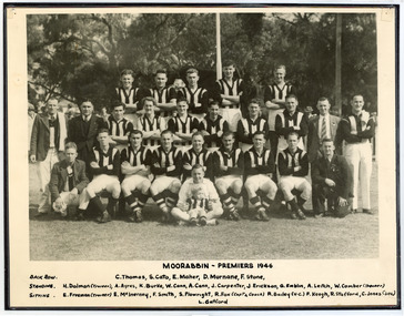
Photograph - Black & White Moorabbin Football Club Premiers 1946, c1946
... orchards ...Moorabbin played initially in the Federal Football League, making their debut in 1909 and competing until 1950. The club wore a black and white jumper like Collingwood. During this time the club won 12 premierships, including winning all six premierships staged over the nine years between 1940 and 1948 (the competition was in recess from 1942 until 1944) Moorabbin had a comparatively brief but quite successful stint in the Victorian Football Association between 1951 and 1963. The club won premierships in 1957 and 1963, and managed a highly impressive overall success rate of 62.5%. However, there was a sensational aftermath to the 1963 flag as Moorabbin fell foul of the VFA after agreeing to sell its ground to VFL club St Kilda. After a bitter wrangle the eventual upshot was that the Moorabbin committee voted 19-2 to disaffiliate from the Association. Before joining the VFA Moorabbin had spent four highly successful decades as a member of the Federal Football League and its precursor the Federal Football Association. During its debut season in the VFA the club played its home matches at Cheltenham, but the development of a new ground in Moorabbin had been a condition of entry. By 1952 that new ground, Moorabbin Oval, was ready, and over the ensuing eleven seasons it would become one of the most difficult grounds in the VFA for visiting teams to win at. Prior to entering the VFA Moorabbin enjoyed premiership success in the Federal Football League on a dozen occasions, including four times in succession between 1945 and 1948.. The Moorabbin name is now used by the Moorabbin Kangaroos Football Club in the Southern Football League. The club was originally known as Moorabbin West Football Club, taking on the new name from 2003. Moorabbin Football Club was established 1909 and was very successful playing in the Federal Football League, Victorian Football Association. Sadly was removed from the Linton St. Oval 1963, after winning the Premiership, by Moorabbin City Council and St Kilda VFL team took over.Black & White photograph showing Moorabbin Football Club 1946 Premiership in Federal Football LeagueMOORABBIN - PREMIERS 1946 / Back Row C.Thomas, S.Cato, D.Murnane, F.Stone, / Standing - H.Dolman (trainer), A.Ayers, K.Burke, W.Cann, A.Cann,J.Carpenter, J.Carpenter, J.Erickson, G.Emblin, A.Leitch, W.Comber (trainer) / Sitting - E.Freeman (trainer) E.MxInerney, F.Smith,S.Plowright, R.Fox (Captain Coach) R.Bailey (vice.Captain)F.Keogh, R.Stafford, C.Jones (Secretary)moorabbin football club, victorian football association, victorian football league, moorabbin kangaroos football club, st kilda football club, linton oval moorabbin, north melbourne football club, smith j l, smith mary ann, stanley helen, chaff cutter, horse drawn carts, toll gates brighton, motor cars 1900, steam engines, early settlers, bentleigh, parish of moorabbin, city of moorabbin, county of bourke, moorabbin roads board, shire of moorabbin, henry dendy's special survey 1841, were j.b., bent thomas, o'shannassy john, king richard, charman stephen, highett william, ormond francis, maynard dennis, market gardeners, vineyards, orchards, sport -
Whitehorse Historical Society Inc.
Document, Motor Cycle Climb and mud bash|A Walk down memory lane|An early glimpse of Royton Street, 1994
... Orchards ...Hartwell Motor Cycle Club.Hartwell Motor Cycle Club. The East Burwood section of its run comprised Holland road, Burwood Road and Ely Road. It was very steep and muddy. Description of a walk along Burwood Road to Middleborough Road in 1929 - 30. History of Royton Street, East Burwood and its neighbourhood from the 1930's to the present.Hartwell Motor Cycle Club. motor cycles, hartwell motor cycle club, holland road, burwood east, eley road, burwood east, burwood east state school no 454, royton street, burwood east, walford family, orchards, cooinda court, burwood east, market gardens, east burwood methodist church, french, joseph a, black, roy, rescheck family, french, harry w, crow, ernie, mclean, leckie, newbigin family, royton street, burwood east, no 30, hele family, french family, carrol family, tally ho post office, walford family -
 Eltham District Historical Society Inc
Opening of Meruka Childcare Co-operative, Meruka Park, 5 Meruka Dr, Eltham, April 1994
In 1919 J.B. North, a violinist with the then Melbourne Symphonic Orchestra, and Monsieur Leon Lambert, a French architect, who later designed the Glaciarium Ice Skating Rink, purchased three available farms, Looker's, Wright's and Taylor's, approximately 60 acres, the area running along the creek and being bordered by the present day Ryans Road, Karingal Drive and Sherbourne Road. The farms were used for orchards and market gardens. Leon Lambert designed and built two homes on the farm site, one for the North family, ‘Tralford’, and the other, ‘Glen Ellen’, for himself and his wife. The homes were considered as "brother and sister" and they each included in their design an identical bay window in the main living area. "Glen Ellen" originally comprised kitchen, lounge room, inglenook, dining room, bath room and sleepout. Although the home has been extended over the years, much of the original architecture has been retained including timber panelling and three fireplaces. The land was subdivided in approximately 1966 with "Glen Ellen" retaining approximately one half acre of land fronting Meruka Drive. The property then passed from the Charleston family to Gerald and Margaret Sutton in 1976 and again was sold in 1980 and lastly sold again in 1994. The Norths named their house 'Tralford'. According to Marjorie North, the name Meruka was suggested by Alan Gardner and so was apparently not used by the North family. The name appears to be of Indian origin and its connection with the land is not known. ‘Tralford’ stayed in the North family for many years. Eltham Council acquired the house to create Meruka Park. The house was used for some years by the Council as a community arts facility and as emergency accommodation. It fell into disrepair and was demolished about 1990. The Meruka Child Care Centre has been built on the site and incorporates some of the architectural features of the old house. The Co-op was opened in April 1994. The original drive flanked by large old cypress trees remains. These trees are considered to be of local heritage significance and for this reason Meruka Park is covered by a Heritage Overlay under the Nillumbik Planning Scheme. Part of the park has been preserved as habitat for rare local flora. LL's house, named ‘Glen Ellen’, remains in a well-preserved state and fronts Meruka Drive.cr pam sladden, eltham, meruka child care co-operative, meruka house, meruka park -
 Eltham District Historical Society Inc
Opening of Meruka Childcare Co-operative, Meruka Park, 5 Meruka Dr, Eltham, April 1994
In 1919 J.B. North, a violinist with the then Melbourne Symphonic Orchestra, and Monsieur Leon Lambert, a French architect, who later designed the Glaciarium Ice Skating Rink, purchased three available farms, Looker's, Wright's and Taylor's, approximately 60 acres, the area running along the creek and being bordered by the present day Ryans Road, Karingal Drive and Sherbourne Road. The farms were used for orchards and market gardens. Leon Lambert designed and built two homes on the farm site, one for the North family, ‘Tralford’, and the other, ‘Glen Ellen’, for himself and his wife. The homes were considered as "brother and sister" and they each included in their design an identical bay window in the main living area. "Glen Ellen" originally comprised kitchen, lounge room, inglenook, dining room, bath room and sleepout. Although the home has been extended over the years, much of the original architecture has been retained including timber panelling and three fireplaces. The land was subdivided in approximately 1966 with "Glen Ellen" retaining approximately one half acre of land fronting Meruka Drive. The property then passed from the Charleston family to Gerald and Margaret Sutton in 1976 and again was sold in 1980 and lastly sold again in 1994. The Norths named their house 'Tralford'. According to Marjorie North, the name Meruka was suggested by Alan Gardner and so was apparently not used by the North family. The name appears to be of Indian origin and its connection with the land is not known. ‘Tralford’ stayed in the North family for many years. Eltham Council acquired the house to create Meruka Park. The house was used for some years by the Council as a community arts facility and as emergency accommodation. It fell into disrepair and was demolished about 1990. The Meruka Child Care Centre has been built on the site and incorporates some of the architectural features of the old house. The Co-op was opened in April 1994. The original drive flanked by large old cypress trees remains. These trees are considered to be of local heritage significance and for this reason Meruka Park is covered by a Heritage Overlay under the Nillumbik Planning Scheme. Part of the park has been preserved as habitat for rare local flora. LL's house, named ‘Glen Ellen’, remains in a well-preserved state and fronts Meruka Drive.eltham, meruka child care co-operative, meruka house, meruka park, cr. peter graham, peter staples, richard allen, sheryl garbutt, bill penrose -
 Eltham District Historical Society Inc
Opening of Meruka Childcare Co-operative, Meruka Park, 5 Meruka Dr, Eltham, April 1994
In 1919 J.B. North, a violinist with the then Melbourne Symphonic Orchestra, and Monsieur Leon Lambert, a French architect, who later designed the Glaciarium Ice Skating Rink, purchased three available farms, Looker's, Wright's and Taylor's, approximately 60 acres, the area running along the creek and being bordered by the present day Ryans Road, Karingal Drive and Sherbourne Road. The farms were used for orchards and market gardens. Leon Lambert designed and built two homes on the farm site, one for the North family, ‘Tralford’, and the other, ‘Glen Ellen’, for himself and his wife. The homes were considered as "brother and sister" and they each included in their design an identical bay window in the main living area. "Glen Ellen" originally comprised kitchen, lounge room, inglenook, dining room, bath room and sleepout. Although the home has been extended over the years, much of the original architecture has been retained including timber panelling and three fireplaces. The land was subdivided in approximately 1966 with "Glen Ellen" retaining approximately one half acre of land fronting Meruka Drive. The property then passed from the Charleston family to Gerald and Margaret Sutton in 1976 and again was sold in 1980 and lastly sold again in 1994. The Norths named their house 'Tralford'. According to Marjorie North, the name Meruka was suggested by Alan Gardner and so was apparently not used by the North family. The name appears to be of Indian origin and its connection with the land is not known. ‘Tralford’ stayed in the North family for many years. Eltham Council acquired the house to create Meruka Park. The house was used for some years by the Council as a community arts facility and as emergency accommodation. It fell into disrepair and was demolished about 1990. The Meruka Child Care Centre has been built on the site and incorporates some of the architectural features of the old house. The Co-op was opened in April 1994. The original drive flanked by large old cypress trees remains. These trees are considered to be of local heritage significance and for this reason Meruka Park is covered by a Heritage Overlay under the Nillumbik Planning Scheme. Part of the park has been preserved as habitat for rare local flora. LL's house, named ‘Glen Ellen’, remains in a well-preserved state and fronts Meruka Drive.eltham, meruka child care co-operative, meruka house, meruka park, cr. john cohen -
 Eltham District Historical Society Inc
Opening of Meruka Childcare Co-operative, Meruka Park, 5 Meruka Dr, Eltham, April 1994
In 1919 J.B. North, a violinist with the then Melbourne Symphonic Orchestra, and Monsieur Leon Lambert, a French architect, who later designed the Glaciarium Ice Skating Rink, purchased three available farms, Looker's, Wright's and Taylor's, approximately 60 acres, the area running along the creek and being bordered by the present day Ryans Road, Karingal Drive and Sherbourne Road. The farms were used for orchards and market gardens. Leon Lambert designed and built two homes on the farm site, one for the North family, ‘Tralford’, and the other, ‘Glen Ellen’, for himself and his wife. The homes were considered as "brother and sister" and they each included in their design an identical bay window in the main living area. "Glen Ellen" originally comprised kitchen, lounge room, inglenook, dining room, bath room and sleepout. Although the home has been extended over the years, much of the original architecture has been retained including timber panelling and three fireplaces. The land was subdivided in approximately 1966 with "Glen Ellen" retaining approximately one half acre of land fronting Meruka Drive. The property then passed from the Charleston family to Gerald and Margaret Sutton in 1976 and again was sold in 1980 and lastly sold again in 1994. The Norths named their house 'Tralford'. According to Marjorie North, the name Meruka was suggested by Alan Gardner and so was apparently not used by the North family. The name appears to be of Indian origin and its connection with the land is not known. ‘Tralford’ stayed in the North family for many years. Eltham Council acquired the house to create Meruka Park. The house was used for some years by the Council as a community arts facility and as emergency accommodation. It fell into disrepair and was demolished about 1990. The Meruka Child Care Centre has been built on the site and incorporates some of the architectural features of the old house. The Co-op was opened in April 1994. The original drive flanked by large old cypress trees remains. These trees are considered to be of local heritage significance and for this reason Meruka Park is covered by a Heritage Overlay under the Nillumbik Planning Scheme. Part of the park has been preserved as habitat for rare local flora. LL's house, named ‘Glen Ellen’, remains in a well-preserved state and fronts Meruka Drive.eltham, meruka child care co-operative, meruka house, meruka park, rob hauser -
 Eltham District Historical Society Inc
Opening of Meruka Childcare Co-operative, Meruka Park, 5 Meruka Dr, Eltham, April 1994
In 1919 J.B. North, a violinist with the then Melbourne Symphonic Orchestra, and Monsieur Leon Lambert, a French architect, who later designed the Glaciarium Ice Skating Rink, purchased three available farms, Looker's, Wright's and Taylor's, approximately 60 acres, the area running along the creek and being bordered by the present day Ryans Road, Karingal Drive and Sherbourne Road. The farms were used for orchards and market gardens. Leon Lambert designed and built two homes on the farm site, one for the North family, ‘Tralford’, and the other, ‘Glen Ellen’, for himself and his wife. The homes were considered as "brother and sister" and they each included in their design an identical bay window in the main living area. "Glen Ellen" originally comprised kitchen, lounge room, inglenook, dining room, bath room and sleepout. Although the home has been extended over the years, much of the original architecture has been retained including timber panelling and three fireplaces. The land was subdivided in approximately 1966 with "Glen Ellen" retaining approximately one half acre of land fronting Meruka Drive. The property then passed from the Charleston family to Gerald and Margaret Sutton in 1976 and again was sold in 1980 and lastly sold again in 1994. The Norths named their house 'Tralford'. According to Marjorie North, the name Meruka was suggested by Alan Gardner and so was apparently not used by the North family. The name appears to be of Indian origin and its connection with the land is not known. ‘Tralford’ stayed in the North family for many years. Eltham Council acquired the house to create Meruka Park. The house was used for some years by the Council as a community arts facility and as emergency accommodation. It fell into disrepair and was demolished about 1990. The Meruka Child Care Centre has been built on the site and incorporates some of the architectural features of the old house. The Co-op was opened in April 1994. The original drive flanked by large old cypress trees remains. These trees are considered to be of local heritage significance and for this reason Meruka Park is covered by a Heritage Overlay under the Nillumbik Planning Scheme. Part of the park has been preserved as habitat for rare local flora. LL's house, named ‘Glen Ellen’, remains in a well-preserved state and fronts Meruka Drive.eltham, meruka child care co-operative, meruka house, meruka park, irene bogle -
 Eltham District Historical Society Inc
Opening of Meruka Childcare Co-operative, Meruka Park, 5 Meruka Dr, Eltham, April 1994
In 1919 J.B. North, a violinist with the then Melbourne Symphonic Orchestra, and Monsieur Leon Lambert, a French architect, who later designed the Glaciarium Ice Skating Rink, purchased three available farms, Looker's, Wright's and Taylor's, approximately 60 acres, the area running along the creek and being bordered by the present day Ryans Road, Karingal Drive and Sherbourne Road. The farms were used for orchards and market gardens. Leon Lambert designed and built two homes on the farm site, one for the North family, ‘Tralford’, and the other, ‘Glen Ellen’, for himself and his wife. The homes were considered as "brother and sister" and they each included in their design an identical bay window in the main living area. "Glen Ellen" originally comprised kitchen, lounge room, inglenook, dining room, bath room and sleepout. Although the home has been extended over the years, much of the original architecture has been retained including timber panelling and three fireplaces. The land was subdivided in approximately 1966 with "Glen Ellen" retaining approximately one half acre of land fronting Meruka Drive. The property then passed from the Charleston family to Gerald and Margaret Sutton in 1976 and again was sold in 1980 and lastly sold again in 1994. The Norths named their house 'Tralford'. According to Marjorie North, the name Meruka was suggested by Alan Gardner and so was apparently not used by the North family. The name appears to be of Indian origin and its connection with the land is not known. ‘Tralford’ stayed in the North family for many years. Eltham Council acquired the house to create Meruka Park. The house was used for some years by the Council as a community arts facility and as emergency accommodation. It fell into disrepair and was demolished about 1990. The Meruka Child Care Centre has been built on the site and incorporates some of the architectural features of the old house. The Co-op was opened in April 1994. The original drive flanked by large old cypress trees remains. These trees are considered to be of local heritage significance and for this reason Meruka Park is covered by a Heritage Overlay under the Nillumbik Planning Scheme. Part of the park has been preserved as habitat for rare local flora. LL's house, named ‘Glen Ellen’, remains in a well-preserved state and fronts Meruka Drive.eltham, meruka child care co-operative, meruka house, meruka park, cr bob manuell, matthew rodscholler -
 Eltham District Historical Society Inc
Opening of Meruka Childcare Co-operative, Meruka Park, 5 Meruka Dr, Eltham, April 1994
In 1919 J.B. North, a violinist with the then Melbourne Symphonic Orchestra, and Monsieur Leon Lambert, a French architect, who later designed the Glaciarium Ice Skating Rink, purchased three available farms, Looker's, Wright's and Taylor's, approximately 60 acres, the area running along the creek and being bordered by the present day Ryans Road, Karingal Drive and Sherbourne Road. The farms were used for orchards and market gardens. Leon Lambert designed and built two homes on the farm site, one for the North family, ‘Tralford’, and the other, ‘Glen Ellen’, for himself and his wife. The homes were considered as "brother and sister" and they each included in their design an identical bay window in the main living area. "Glen Ellen" originally comprised kitchen, lounge room, inglenook, dining room, bath room and sleepout. Although the home has been extended over the years, much of the original architecture has been retained including timber panelling and three fireplaces. The land was subdivided in approximately 1966 with "Glen Ellen" retaining approximately one half acre of land fronting Meruka Drive. The property then passed from the Charleston family to Gerald and Margaret Sutton in 1976 and again was sold in 1980 and lastly sold again in 1994. The Norths named their house 'Tralford'. According to Marjorie North, the name Meruka was suggested by Alan Gardner and so was apparently not used by the North family. The name appears to be of Indian origin and its connection with the land is not known. ‘Tralford’ stayed in the North family for many years. Eltham Council acquired the house to create Meruka Park. The house was used for some years by the Council as a community arts facility and as emergency accommodation. It fell into disrepair and was demolished about 1990. The Meruka Child Care Centre has been built on the site and incorporates some of the architectural features of the old house. The Co-op was opened in April 1994. The original drive flanked by large old cypress trees remains. These trees are considered to be of local heritage significance and for this reason Meruka Park is covered by a Heritage Overlay under the Nillumbik Planning Scheme. Part of the park has been preserved as habitat for rare local flora. LL's house, named ‘Glen Ellen’, remains in a well-preserved state and fronts Meruka Drive.eltham, meruka child care co-operative, meruka house, meruka park, cr pam sladden, mandy press -
 Melton City Libraries
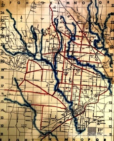
Map, Mount Cottrell Fire group, Unknown
"In 1966, the Mount Cottrell Fire Brigades Group was formed as a way of consolidating the smaller groups around Melton, Rockbank, Toolern Vale, Sydenham, Truganina and Werribee. Its headquarters were established at the home of Ernest ‘Bon’ and Edna Barrie in Ferris Road, Melton. Captain Bon Barrie was a member of the Melton Fire Brigade and elected group and communications officer of the new Mount Cottrell Brigades Group". Fire Brigade Meeting 14th September held at Rockbank Formation a new Group in Region 14 Present: R/O H Rothsay, Assistant R/O R Orchard Tru? G Summerton Purpose of Group The pooling of the equipment in the area should be co-ordinated under one leader. The Brigade and private equipment should be co-ordinated under one leader. Formation was carried unanimously. To be called Mt Cotterill Group. Rockbank nominated Captain E W Barrie elected, Secretary K Watt Toolern Vale. Names listed C/O K L McNaughton Anakie Group COO/O R B Chirnside Lieut J Richmond Capt E Gillespie Toolern Vale Eddie L/ T S Atkin Stan L/T B Storey Bert Sec K Watt Keith Capt E W Barrie Melton Bon L/T K Gillespie Keith A Gillespie Arthur L/T G Lunson George L/T J Robinson Jeff Capt A Marquand Truganina Alan L/T I Cowie Ian Sec T Gard Tom Capt G Harrison Rockbank a/ps G Harrison N Harrison N Fisher a/ps S Hirt Melton Steve Pres M Chomley Sydenham Capt S Hughes Stan Capt L Waterson Werribee Lex Res/o J Hanson G/O S Cooper Bacchus Marsh Syd P/GO W Lidgett Wal Pro/O D Dunton G/O T Healy R C [Mt Macedon] Tom Reg Sec G Douglas Hand written notes of Edna Barrie Typed by Wendy Barrie Maps of the Mt Cottrell Fire groupemergency services, maps -
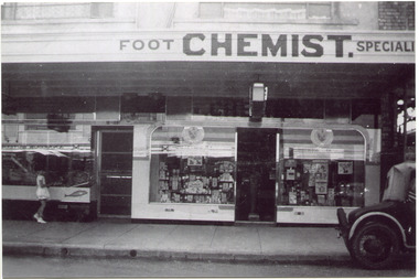 City of Moorabbin Historical Society (Operating the Box Cottage Museum)
Photograph, Black & White, Mr Moore's 1st Chemist Shop Centre Road, Bentleigh c1930, c1930
... orchards ...Early settlers in the Parish of Moorabbin, County of Bourke, established market gardens and farms in the area of Henry Dendy's Special Survey 1841 Brighton. Small communities grew near Churches & Schools and shops and businesses were established. Following the opening of the Railway line from Caulfield to Mordialloc 1881 the shops and business moved from the Tucker Road /Centre Road ( East Brighton ) East Bentleigh area to be close to the transport. Shops, businesses and housing developed along Centre Road between Thomas Street and Jasper Road. Mr Arthur Moore established his 1st shop in 395 Centre Road c1930 and later moved along the road to a site next to Coles Variety Store.Following the opening of the Railway line from Caulfield to Mordialloc 1881 the shops and business moved from the Tucker Road /Centre Road East Bentleigh area to be close to the transport. Shops, businesses and housing developed along Centre Road between Thomas Street and Jasper Road. Mr Moore established his 1st shop in 395 Centre Road c1930 and later moved along the road to a site next to Coles Variety Store.Black & White photograph of Mr Arthur Moore's 1st Chemist Shop, 384 Centre Road Bentleigh c 1930 back Handwritten information unsignedbentleigh shopping centre c1930, east brighton, railway line caulfield -mordialloc 1881, chemists, pharmacy, moore's moorabbin shire, smith j l, smith mary ann, stanley helen, smith vic, smith harry redvers, chaff cutter, horse drawn carts, toll gates brighton, motor cars 1900, steam engines, early settlers, bentleigh, mckinnon, parish of moorabbin, city of moorabbin, county of bourke, moorabbin roads board, shire of moorabbin, henry dendy's special survey 1841, were j.b., bent thomas, o'shannassy john, king richard, charman stephen, highett william, ormond francis, maynard dennis, market gardeners, vineyards, orchards -
 Bendigo Historical Society Inc.
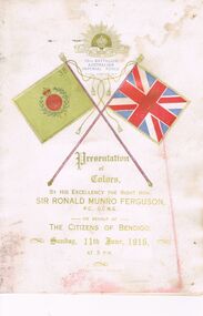
Book - AUSTRALIAN COMMONWEALTH MILITARY FORCES 38TH BATTALION AIF PRESENTATION OF COLOURS JUNE 11, 1916, 11th June, 1916
Card and Paper Booklet Australian Commonwealth Military Forces 38th Battalion Australian Imperial Force. Presentation of Colours by His Excellency The Right Hon. Sir Ronald Munro Ferguson, P.C. G.C.M.G. Governor-General and Commander in Chief of the Commonwealth of Australia, on behalf of The Citizens of Bendigo Sunday June 11, 1916 at 3pm. Regimental Staff: Lieut-Colonel C.H. Davis Commanding; Major R.O. Henderson 2nd in Command; Captain A. Fraser Adjutant; Captain J.M. McCusker Medical Officer; Captain R.M. Marks Quartermaster, Captain W.N. Gunson Chaplain; R.S.M. Warrant Officer P.S. Spark; R.Q.M.S Warrant Officer P.J. Telfer Orderly Room Sergeant H.W. Joseph; Band Sergeant J.J. Coe; Armourer Sergeant A.Runting. On Parade with Colours:- Lieut, F.E. Fairweather King's Colours; Lieut, J.H. Moore Regimental Colour. Companies Present (A. Company) - Captain G.V. Lansell, O.C; Captain R.E. Trebilcock; Lieut F.E. Fairweather; Lieut, L. Lipshut; Lieut, W.J. Collins 2nd Lieut C.H. Peters. (B Company) Captain L.L. Smith, O.C; Captai, E.F. Moore; Lieut, H. Dench; Lieut, E. W. Latchford; 2nd Lieut, F.C. Morrison; 2nd Lieut, F.R.B. Martin. (C: Company) Major G. Hurry, O.C., Captain J. Akeroyd; Lieut, R.D. Tyres; 2nd Lieut, J.L. Whitehead; 2nd Lieut W. Maxwell; 2nd Lieut H. McColl. (D Company) Captain A.J.A. Maudsley O.C.; Captain H.F. Selleck; Lieut J.H. Moore; 2nd Lieut W.L. Bogle; 2nd Lieut W. Williams; 2nd Lieut A.L. Reid. (Reinforcements) 1st/38th Lieut W.H. Orchard, O.C.; Machine Gun Section 2nd Lieut J.B. O'Donnell. T.E. Green, Hon. Secretary.bendigo, clubs, australian imperial force 38th bat -
 Eltham District Historical Society Inc
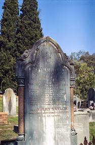
Negative - Photograph, Harry Gilham, Grave of Abraham and Ann Taylor, also Mary Taylor, Eltham Cemetery, Victoria, Sep 2009
Abraham Taylor was born 20 October 1811 in Derrycarn, Drumcree Parish, County Armagh, Ireland, the son of Richard William Taylor and Annie Abraham. He married Ann McClelland on 19 February 1852 in Dumcree. They emigrated to Australia arriving in Geelong aboard the Ann Thompson on Christmas Day, 1852. His younger sisters Mary and Martha and brother William John all having separately preceded them in 1851 and 1852. Abraham and Ann settled in Little Eltham, Abraham was recorded as being 40 years of age and Ann, 36. They made their home and living as an orchardist and gardener where they had three sons, William John (1853 Little Eltham), Richard (1855 Eltham) and Robert David (1857 Eltham), tow of whom became Councillors of the Shire of Eltham; William (1890-1911) and Robert David (1911-1920). In June 1871, Abraham Taylor, Eltham gardener, applied for a 120-acre allotment half a mile northeast of the Research Gully Hotel on June 30, 1871. A license was issued to him January 30, 1872, for 114 acres, being Allotment 8, Section 18, the balance of 6 acres being retained for reserve. He built on the land a two roomed dwelling of slabs and palings. He and his family lived there or at their 6 ½ acre Eltham property, which was used for orchard and garden as a residence. In January 1875 a lease issued to Abraham Taylor for the land one chain wide each side at the gully named ‘Wet Gully’ was excluded. In August 1881 Abraham Taylor paid up all fees and applied for a Crown grant. He vainly requested that the grant be issued to his son, Robert David Taylor, Eltham however the grant was in fact issued to Abraham Taylor, Eltham, gardener. Abraham died at home on June 1, 1890. He was greatly respected by all who knew him. His sister Mary predeceased him 1873and is also buried at Eltham cemetery. Wife Ann died at home 1 September, 1893 and was buried with him. In Loving Remembrance of Abraham Taylor Who died June 1st 1890 Aged 80 years Also Ann Taylor Wife of the above Who died September 1st 1893 Aged 75 years Also Mary Taylor Who died September 22nd 1873 Aged 45 yearsRoll of 35mm colour negative film, 6 stripsKodak GC 400-9eltham cemetery, gravestones, abraham taylor, ann taylor, mary taylor -
Eltham District Historical Society Inc
Document - Folder, Mann, John and Violet and family
John Mann arrived from Forfar, Scotland, on the clipper packet "Ellen Stuart" in 1857 and rented a farm "Overton" at Janefield. Soon after he met Melbourne-born Violet McKimmie, whose parents had a property near Darebin Creek. They married on 25 September 1862, John 26 and Violet 19. In 1874 John selected a block on Arthurs Creek and built a slab and bark hut (still standing in 1984) and called their farm "Carseburn" after John's parish in Scotland. They had seven children: John, Jane, Christine, David, Walter, James and Violet. John was drowned in the Yarra in May 1875 and Violet struggled to meet the lease commitment. She wrote to her brother-in-law David Mann in New Zealand who came to her aid, and on 10 September 1876, they married at the Victorian Free church, Smith Street, Collingwood. They improved the farm and built a three-room house. in July 1883 they bought neighbouring land from Ann Welsh. With David, Violet had four more children: Robert, William and twins Thomas and Henry. In 1883, David died and was buried in the same grave as his brother in Preston Cemetery. The twins also died, Thomas just before and Henry just after their father. the children assisted with the farm and orchard, the business including crops, a dairy herd, Carseburne sheep, and breeding horses. Violet died at Yan Yean in 1925, aged 83. A grandson of John Mann, James Mann, lived in Henry Street, Greensborough and had given a talk at the Whittlesea Historical Society in 1983 on his family. Descendant Lindsay Mann was part of a creative writing group that published a book including a short story "The Mountain Tramway" is loosely based on his childhood and stories he was told then but was planning to write his family story. Contents Newspaper article: "Tragedy couldn't stop this pioneer", Diamond Valley News, 31 January 1984, story of Mann family. Newspaper article: "Tracing the history of ordinary. people," Diamond Valley News, 29 July 1986, story of Mann family, researched by descendant Lindsay Mann who grew up at the Mann property She-Oak at Yan Yean and has numerous family records. Newspaper article: "A realist who captures light," Diamond Valley News, 29 July 1986, David Moore, a realist painter had been working from a studio at Montsalvat and his exhibition of work from that period was to open 1 August 1986 at the Victorian Artists Society Galleries.Newspaper clippings, A4 photocopies, etcjohn manan, violet mann nee mckimmie, clipper packet "ellen stuart", forfar scotland, darebin creek victoria, arthurs creek victoria, "overton" at janefield, "carseburn" at arthurs creek, jane mann, christine mann, david mann, walter mann, james mann, violet mann, victorian free church smith street collingwood, ann welsh, robert mann, william mann, thomas mann, henry mann, preston cemetery, carseburne sheep, yan yean cemetery, lindsay mann, david moore, montsalvat -
 Ringwood and District Historical Society
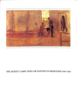
Book, Helen Tolpliss, The Artists Camps: Plein Air Painting In Melbourne 1885-1898, 1984
Image of a Charles Conder painting on front of soft covered book titled The Artists' Camps: Plein Air Painting In Melbourne 1885-1898. FOREWORD by Margaret Plant - Department of Visual Arts, Monash University. The paintings of the 'Heidelberg school" are the best loved group of works in Australian art. The affection is linked in the national mind with a recognition that the authentic Australian landscape had been discovered and colonial bonds broken. The painting activity of the 1880s and 1890s was by no means confined to Heidelberg. Helen Topliss painstakingly presents the variety of sites around Melbourne, in the bush and on the coast, reconstructing their original character and the history of their accessibility. The major figures are well known — Roberts, McCubbin, Streeton and Conder — but there were a number of 'minor' artists associated with the various painting spots that have been too long neglected. A research programme is here initiated in the hope that some of these figures might be more fully returned to us. The restoration of the sites provokes a more extensive roll-call of artists involved in the plein air phenomenon. Various expressions of nationalism in the late nineteenth century have been accorded attention: the painters contributed in varying degrees. But it is, finally, the quality of the painting, the freshness, the particularity of nuance, the calculated aesthetic angles that have governed response and inspired affection. The elegant relaxation themes of many of the paintings have in fact been overlooked in the intellectualization of the quest for 'national identity'. The orchards and the beaches, the ladies promenading a la mode on the beach at Mentone or in the grasses of Box Hill are as important to our artistic tradition and social history as the shearers of rams. -
 The Beechworth Burke Museum
Photograph, c1885
This carte de visite was taken of Hiram Crawford in fire brigade uniform taken by Stewart & CO., Melbourne. Hiram Crawford was Captain of the Beechworth Volunteer Fire Brigade for twenty-five years. Hiram arrived in Australia at the age of 21 in August 1853. He mined for short time at Back Creek Bendigo, then went to the Ovens where he sought gold in Spring Creek, Buckland and 3 Mile. After moving to Albury for 18 months he married Anna, moved to Woolshed and was there for two years mining gold. After discovering his fortune he formed Crawford and Co. Coaching Lines in Beechworth in late 1856. It was this company which became the longest surviving coaching business in the State of Victoria. Hiram and Anna had two daughters. Anna died in March 1862 and in May Hiram left from Melbourne to return to the United States on a visit. Hiram married Martha Foster during this visit and returned to Australia in March 1863. With his coach line established, and leaving it under management, he moved around the north east of Victoria establishing and building shops and the Star Hotel and Theatre in Chiltern in 1866. In 1869 he moved to Melbourne for a few years in which time he built the Eastern Arcade in Bourke Street. In 1876 the family returned to Beechworth for a few years eventually moving to Everton where Hiram grew hops, tobacco, fruit trees and established the largest lemon orchard at that time in Australia. Hiram spent a considerable amount of his time helping to develop the North East of the State not only in his private endeavours but as a public figure. Among his many achievements a few are listed - Councillor, Mayor of Chiltern and Beechworth, President of the Shire on two occasions, Director of many mining companies, Inaugural Chairman and Director of the Beechworth Gas Company roles he held for over 20 years, Foundation member of Beechworth Pottery, Committee member of the Beechworth Hospital, Captain/Superintendent of the Vol. Fire Brigade for over 20 years, Foundation, Life member of and on the State Fire Brigade Board for many years, President of the North Eastern Railway League in Chiltern On a personal level Hiram was involved in lodges including St. Johns #14, Beechworth. and had several grazing properties in the Ovens area. He had the Forest Park Hotel at Carboor, the Creamery at Carboor, and grazing land on which the Milawa Creamery was built during his ownership. He was a committee member for 3 committees duirng the 1888 International Exhibition in Melbourne. Hiram had many voyages around the world studying irrigation, hop growing, tobacco growing and drying. During his retirement in Melbourne Hiram purchased many properties in the Elsternwick area and acted as an Estate Agent. After the death of his second wife Martha, Hiram married for the third time in 1912 to Sophia Maude Heatley. Crawford and Co continued until 1921. [Taken from HighCountryHeritage.com.au]Black and white reproduction of a studio portrait of Hiram Crawford in fire brigade uniform, printed on gloss photographic paper and bordered with a white frame.Badge on uniform sleeve reads: CAPTAIN / BVFB Obverse: AB/ Stewart & CO./ Melbourne Reverse: Hiram Collection/ BMM2435burke museum, emergency services, beechworth, carte de visite, black and white, fire brigade, hiram crawford, stewart & co., melbourne. -
 Eltham District Historical Society Inc
Photograph, Peter Pidgeon, Graves of George and Janet Bird and family, Eltham Cemetery, Victoria, 5 April 2021
George Bird was born in England in 1845 and arrived in Australia in 1856 as a child of assisted migrants. Soon afterwards he came out to Eltham to live with his uncle George Stebbings, working for him as bricklayer's assistant in building, amongst others, Shillinglaw Cottage and the Anglican and Methodist Churches in Eltham. He later purchased 72 acres at the eastern end of Pitt Street (bounded by Eucalyptus Road, Mount Pleasant Road and present-day Rockliffe Street) and established the property ‘View Hill’, which was worked as a mixed farm and orchard (including berries). In 1878 he married Janet Kilpatrick, who had emigrated from Scotland. They had ten children, three of whom died in infancy. The wedding in 1904 of their eldest surviving daughter Sarah (‘Sis’) to Edward Pepper appears to have been quite a society event. George was a staunch Methodist and was a Church Steward and a Sunday School Superintendent in about 1890. Janet died in 1915 and George died in 1920 (though his gravestone says 1921). George's will stated that his property was to be divided between all his children in equal shares. This necessitated subdivision of the View Hill property, which took place progressively between 1922 and 1926. One son, George Hugh Bird, operated a drapery store in Main Road (near Bridge Street) in around 1915. Later, in the 1920s, he ran a greengrocer's shop (also selling confectionery) in Main Road opposite Eltham Station. It was the first shop in Eltham to have plate glass windows. At the same time, his brother Reg had a grocery store on the station side of Main Road. George and Janet are buried together in a family plot in Eltham Cemetery. Several descendants are also buried in the cemetery. In Loving Memory Of George Bird Died 5 December 1921 aged 76 years And his beloved wife Janet Bird Died 5 Sept 1915 aged 57 years Also their children William James Bird Died 25 Feb 1888 aged 8 years Mary Jane Bird Died 8 Oct 1891 aged 7 years Pte Edwin John Bird Killed in action in the Great War 11 Aug 1918 aged 30 years Buried in France And on the base stone George Hugh Bird Died 26 Feb. 1965. Aged 79 years Arthur Andrew Bird Died 25 Mar. 1970 Aged 75 years To the left In Loving Memory of Dr. J. R. (Roger) Bird 1927 2001 Son of Arthur & Helen (nee Lyon) Bird Husband of Betty Father of Janet & Alison Grandpa of Evan & Helen Scientist & Gentleman To the right In Loving Memory of Harold Edwin Bird OAM 1922 - 2015 Son of Arthur & Helen (nee Lyon) Bird Husband of Yvonne Father of Estell & Russell In our hearts Forever moreBorn Digitaleltham cemetery, gravestones, arthur andrew bird, arthur bird, edwin john bird, george bird, george hugh bird, harold edwin bird, helen bird (nee lyon), j. r. (roger) bird, janet bird (nee kilpatrick), william james bird, yvonne bird -
 Eltham District Historical Society Inc
Photograph, Peter Pidgeon, Grave of Guido Quarto Fabbro, Eltham Cemetery, Victoria, 5 April 2021
Guido Quarto Fabbro was born 21 August 1891 at Treppo Grande in the far northeast of Italy, the son of Giacomo Fabbro and Anna Geruzzi. Regina Moretti was born 6 March 1893 at Treppo Grande, Italy, the daughter of Giovanni Battista Moretti and Maria Teresa Coletti. Guido and Regina married about 1917 and they had two sons, Giacomo (John c.1918) and Maurie (c.1920). In 1925 Guido Fabbro departed his homeland from Genoa, arriving in Fremantle, Western Australia in June, travelling 3rd class aboard the ship, Caprera. Regina and their two boys followed a year later along with other family members arriving in Fremantle from Genoa 4 July 1926 aboard the Moncalieri. The Fabbro arrived in Eltham in 1933 and purchased a block of land from William West on the western side of Falkiner Street, extending to Ely and Porter Streets which had formerly been part of the West family orchard and dairy farm. As there was no fencing dividing the two properties, West served notice on Guido in December 1934 to bear half of the cost of £6. When payment was not forthcoming, West sued Guido in the Eltham Court in January 1935. Guido failed to appear and was not represented, and costs were ordered in West’s favour. Guido and Regina built a large Italianesque house on their property. The original 1860s cottage was relocated to the back of the block and was rented out (once to Alistair and Margot Knox). Guido also purchased land extending to the Diamond Creek on the eastern side of Falkiner Street and on the eastern side of Bell Street (opposite Eltham High School). The riparian soil was suitable for market gardening: Guido grew mainly tomatoes, but also pumpkins, cauliflowers, cabbages, peas, beans, lettuce, beetroot and zucchinis. Even the land surrounding the house was used. The produce was carted to Melbourne overnight for sale at the market. Guido died in 1970 and is buried in Eltham cemetery. Regina died 1986. She and their son John Patrick (Giacomo) Fabbro who died in 1984 are also buried at Eltham Cemetery. Guido’s son Maurie continued in his father’s footsteps until 2007, principally growing artichokes in later years. He died in 2009. The land on the eastern side of Falkiner Street now forms part of a Council reserve called “Barak Bushland”, the land on the western side having been sold off for residential subdivision. The Bell Street land is now public open space managed by Nillumbik Shire Council and called “Fabbro Fields”. There have been recent proposals to develop the site for sporting purposes or as a dog park or community garden. In Memory of Guido Quarto Fabbro Beloved husband of Regina Died 15-3-1970 aged 79 R.I.PBorn Digitaleltham cemetery, gravestones, guido quarto fabbro, regina fabbro