Showing 4515 items
matching farm
-
 Kew Historical Society Inc
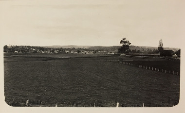
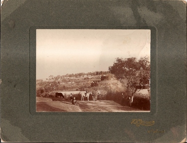
Photograph - Farmland, near Bruthen or Swan Reach, 1926
Henry Beater Christian (1886-1962) , was a descendant of one of the earliest settler families in Kew. Employed at the Kew Asylum as a 'public servant', he was a skilled amateur photographer, photographing numerous scenes in Kew and on his travels around Victoria. The majority of his photographs date from 1916 to 1929. His finest photographs are housed in two photograph albums. Digital copy of a photograph from page 31 of the 47-page photograph album containing 261 gelatinous silver images, loaned by Diane Washfold with permission given to digitise and hold a copy in our collection. John Chapman has written in 'Bushwalking Clubs - A Brief History', about the establishment in Victoria of the first bushwalking club in 1888, and the popularisation of bushwalking during the interwar period. Henry Christian's 'walks' appear to have been undertaken solely or with a companion/s. This black and white photo is part of a group of six photos taken on an 18 kilometre walking trip between Bruthen and Swan Reach in East Gippsland in 1926. The route of the walk followed the Tambo River. The photographer focusses the camera view on the township in the distance with farms in the foreground."BRUTHEN TO SWAN REACH 1926"henry beater christian (1886-1962), landscape photography, christian-washfold collection, photograph albums, bushwalking, bruthen, swan reach, tambo river, east gippsland -
 Charlton Golden Grains Museum Inc
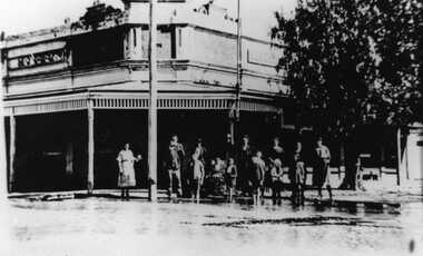
Photograph, 1923 Flood - Telegraph Hotel, Armstrong Street Charlton, c. 1923
1923 Flood, Telegraph Hotel, Armstrong Street, Charlton, Victoria1923 flood - Telegraph Hotel, Armstrong Street Charlton. Obituary: Charlton 100 years ago 18-02-1922 - 24/02/1922. Mr Francis Gilbert Livingstone passed away at Castlemaine on 14th ins. He was a very well known & highly respected old resident of Charlton & Narrewillock. Until October last he held the license of the Telegraph Hotel and was a familiar figure in his wheel chair under the shade trees at land at Narrewillock, where he farmed until failing health compelled him to give up the strenuous work of those early pioneering days, and in 1892 he took the license of the Telegraph Hotel which he retained until recently. He was 61 years of age.flood, telegragh hotel, charlton, livingstone -
 Bendigo Military Museum
Photograph - PHOTOGRAPH, FRAMED WW1, Wayne Eels, C.2008/09
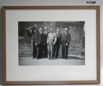
The Grinton Collection. Photo taken at a 38th Bn reunion at Bert Grintons Farm Myers Flat near Bendigo. Left to Right in photo; Jack Grinton, Fred Lehmann "MM", Dick Verso, Bert Grinton "DCM" , ..........Poppin. "Jack Grinton No. 1038," 38th Battalion - Refer Cat No. 1280 for his service history. "Bert Grinton DCM, No. 5024" - Refer Cat No. 1320 for his service history. Photograph - framed. Photograph - black and white photograph on paper depicts an informal group, full length portrait of six men. Background - wall of stone and timber building. Frame - timber, light varnish finish, Perspex front, cardboard backing."Single photos Group 2 (end of show): 38th Battalion Reunion".framed accessories, camera on the somme, ww1, 38th bn, grinton -
 Warrnambool and District Historical Society Inc.
Documents, Letter: 30 July 1917 To Gladys from 3117 Pte SO Miller, pre 30 July 1917
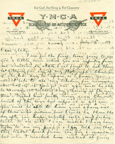
Original correspondence from SO Miller to Gladys Holmes, Bakery, Byaduk written from abroad in July 1917. 3117 Pte Stanley Owen Miller was born in London, England. He worked at the McGillivray farm, Byaduk. Enlisted 8th January 1917 and served with the 38th Battio - 7th Reinforcements and embarked on the HMAT A70 Ballarat. Killed on 7th June 1917 at Villiers Bretonneux, France, aged 20. Original correspondence envelope and two page letter written by an Englishman to Gladys Holmes of the Bakery, Byaduk. When working on the McGillivray farm at Byaduk in 1917 he enlisted in the A.I.F. One of fourteen items of documents gifted, all correspondence from abroad to Byaduk residents. 001804.1 - 001804.1R: Envelope- Y.M.C.A. branded issue, black ink postmark and 1d red stamp 001804.2-001804.3R Two sheets of Y.M.C.A. paper, buff with central black YMCA logo, 'For God, For King & For Country' with "HM FORCES ON ACTIVE SERVICE' superimposed on reversed machine guns and two red and blue Y.M.C.A. logos written in blue ink on both sides. 001804.9.-.001804.9R: small black and white photograph of a soldier with 11 lines of handwritten descriptive text on the reverse. 001804.1 -1R: Y.M.C.A. envelope handwritten 'On active service abroad' addressed to Miss G. Holmes/Byaduk (Bakery)/Via Hamilton/Victoria/Australia. Red 1d pRE Reverse- Byaduk/Byaduk/M Miss G.I. Holmes 001804.2- 001804.3R: Three pages of blue ink handwriting on Y.M.C.A. letter paper. Abroad/ Dear Gladys....I remain yours S.O.Miller.gladys holmes, so miller, 3117, hmat a70 ballarat, villiers bretonneoux, byaduk memorial hall, honour board, ww 1, letter, y.m.c.a., photograph, diet sheet, villers bretonneux, byaduk memorial hall honour board, england -
 Eltham District Historical Society Inc
Document - Folder, Warrandyte Bushfire Relief, 1962
Following the January 1962 bushfires in Warrandyte, affected land holders and residents made application for financial assistance. These records are a small part of more than 1,300 applications made at the time. Contents include: Approximately 200 applications for assistance which include details of property, residence (holiday, farm holding, main residence), residents and property loss Approximately 500 Council responses for each application Miscellaneous correspondencePovides a clear description of property ownership, type, size, holdings and people at the timeapplication form, assessments, bushfire relief, eltham shire council, north warrandyte, scan - tbd, victorian bushfires - 1962, warrandyte -
 Greensborough Historical Society
Photograph, Willis Vale 1906, taken from the hill, 1906_
'Willis Vale' home of the Partington family is shown in this photograph as well as the area now known as Partington's Flat. The area was owned and farmed by the Partington family from the 1870s. The derelict Willis Vale house was destroyed in 1964 when a fire originating from North Plenty Gorge - Kurrak Road - lit by two teenage boys - made its way several kilometres down to Partington's Flat Greensborough.Photograph shows an early view of Greensborough in 1906.Professional photograph in sepia mounted on dark green card. Shows Greensborough township in background with Willis Vale homestead in centre. On back: A.M.Partington Greensborough 1906.willis vale, partington family, greensborough, alan partington -
 Greensborough Historical Society
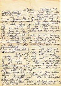
Notes - Digital Image, Cherel Sartori, Notes on conversation with Claude Amiet 1992, 1992_
Notes of Cherel Sartori's conversation with Claude Amiet in 1992 at Kell's Cottage. The house was built 1917, at 112 Henry Street Greensborough by William Mitchell on the 60 acre dairy farm owned by Ethel and Walter Kell. This collection of photographs was copied by Cherel Sartori (who owned the house from 1990-2000), following a visit by Claude Amiet who lived in the house as a child in the early 20th century.Digital copy of handwritten noteskell's cottage, claude amiet, cherel sartori -
 Eltham District Historical Society Inc
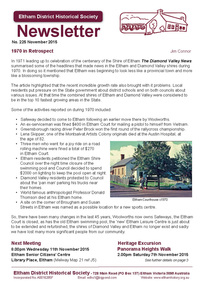
Newsletter, Newsletter, No. 225 November 2015
Contents: • 1970 in Retrospect by Jim Connor • November Meeting - A Virtual Eltham Literary Tour • ANZAC Centenary interpretive signage • November Excursion - Panorama Heights Walk • Young History • Book Review - Montmorency - The Farm on the Plenty by Jim Connor • Our new banner and the Eltham Festival • A Lively Researcher from Research by Adrian Jones • Our Christmas Function • ....and also • Contacts for the Eltham District Historical Society The Shire of Eltham Historical Society was formed in October 1967. The first newsletter of the Society was issued May 1978 and has been published continuously ever since on a bi-monthly basis. With the cessation of the Shire of Eltham in late 1994, the Society's name was revised to Eltham District Historical Society and this name first appeared with issue No. 103, July 1995. The collection of the Society's newsletters provides a valuable resource on the history of the Society's activities, office bearers and committee members, guest speakers and subjects of historical interest pertinent to the former Shire of Eltham and the Eltham District.A4 photocopied newsletter distributed to membersnewsletter, eltham district historical society, shire of eltham historical society -
 Warrnambool and District Historical Society Inc.
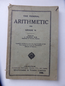
Book, The Federal Arithmetic, Early 20th century
This is a Grade V Arithmetic book used by George Bonnett at Allans Forest School. The Bonnett family farmed in the Mepunga area on the Childers Cove Road. The Allans Forest State School, number 1086, was established in 1871 and closed in 1993. The first Head Teacher was Mr Bradhurst. The school closed in 1903 and re-opened in 1905 as a half-time school with Mepunga East and in 1908 it resumed as a full time school. This book is significant because it was used by George Bonnett at the Allans Forest State School and is a memento of both the Bonnett family of Mepunga and the Allans Forest State School, a school no longer existing. It is also of antiquarian interest as an example of arithmetic school text books used early in the 20th century. This is soft cover book of 128 pages. The cover is grey with black print and black lines around the edges of the front cover. The book has a prefatory note, arithmetical exercises and advertisements for other school text books published by Whitcombe and Tombs. The cover is torn and soiled and partly ripped away. There is handwriting in black ink on the first page.‘George H. Bonnett, Allans Forest State School’bonnett family, mepunga allans forest state school history of warrnambool -
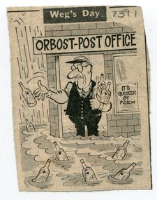 Orbost & District Historical Society
newspaper clippings, February 1971
These articles were compiled by Mary Gilbert who was the first curator of the Orbost Museum and a prominent historian / teacher in Orbost. The 1971 floods at Orbost were the worst on record. At Jarrahmond the river rose to a height of 11 metres and on the flats spread to one and a half kilometres wide. Considerable damage was done to railway infrastructure, roads and farms. More information from the APRIL, 2008 newsletter by John Phillips. (see orbosthistory.com.au)These articles are contemporary records of a significant historical event in Orbost.A manila folder containing black / white newspaper clippings from various publishers. They all relate to the 1971 floods in Orbost. (Details of contents in catalogue 735-900)floods-orbost-1971 -
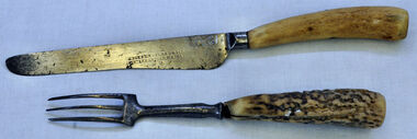 Orbost & District Historical Society
knife and fork, Joseph Rodgers & Son
The Tabbara Sawmill was located at Brodribb River, at the lower Snowy River estuary. In the early 1900’s bow saws and broad axes were used to selectively log the forest. Ox driven carts pulled the logs to the Snowy River; the logs were floated downstream to the steam powered mill. The PS Curlip steamboat, transported the timber to growing townships, for schools, houses and farms. The mill closed in 1903. Knife and fork with steel blades and bone handles..Knife - Joseph Rodgers & Son Cuttlers to her Majestyknife fork cutlery domestic-item rodgers-joseph -
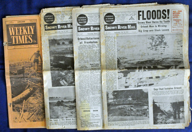 Orbost & District Historical Society
newspapers, February, March 1971
The 1971 flood was the the worst flood on record. At Jarrahmond it was at least 11 metres and up to one and a half kilometres wide on the flats causing enormous damage to the flood plain. Records say that "The brown floodwater stain in Bass Strait could be seen from passing airliners." Considerable damage was done to railway infrastructure, roads and farms. More information from the APRIL, 2008 newsletter by John Phillips. (see orbosthistory.com.au) These newspapers are contemporary records of a significant local event.Four newspapers relating to the floods in 1971. They contain news articles and photographs of the floods in Orbost in early 1971. 2556.1 is the Weekly Times dated 3.3.1971 and has an orange cover. 2556.2 is a Snowy River Mail dated 17.2.1971. 2556.3 is a Snowy River Mail dated 10.2.1971. 2556.4 is a Snowy River Mail dated 3.3.1971.floods-orbost-1971 snowy-river-mail weekly-times newspapers -
 Glen Eira Historical Society
Document - ROSEMONT, KOOYONG ROAD, 112A, CAULFIELD NORTH
Two items about this property, both 110 and 112 Kooyong Road: 1/Photocopied carbon copy about 110 Kooyong Road, which is situated in the grounds of ‘Rosemont’ farm. Includes details of former residents to 1985. Photocopied black and white photo by Carol Stals, c.2013. 2/Two photocopied colour photos of ‘Rosemont’, 112 Kooyong Road, taken by Carol Stals, c.2013.kooyong road, caulfield north, rosemont farm, howitt. godfrey dr, howitt alfred, henderson garnet w, henderson m. m miss, haskin joseph, anstee w. e, holst edward, balaclava road, howitt street, rosemont street, bullock h miss, landells rosalind -
 Whitehorse Historical Society Inc.
Mixed media - Doll House Verandah, Yvonne Fitzmaurice, Doll House Veranda, 1974
Hand-made child's doll's house. Built by Mrs Yvonne Fitzmaurice and finished in 1979. This house was built as a 1:12 scale and is a model of a Californian house called Peppercorn farm. House was built by Yvonne and her family and took a period of three years. A lot of the furniture is handmade and the rest is collected from various shops. Catalogued books, manuals, repair kits etc used when building the house.The white painted verandah has a brass plate beside the door with the name Susan Fitzmaurice. In front of the door is a door mat and the veranda has a white hanging seat and a timber flower box with flowers."Susan Fitzmaurice" name on front of building. Date on plaque on top of front wall. Contents: - flower box with flowers, wooden swing, door mat. -
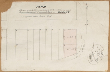 Bacchus Marsh & District Historical Society
Map, Plan showing relative positions of the Gisborne road formation and Mr. Cosgrove's land in Darley. 1907
No background information about the roadworks referred to in this plan has been found. The portion of land referred to as 'Cosgroves' in this plan is located close to the present day Darley Park Recreation Park in Darley, near Bacchus Marsh. The land indicated appears to be close to the corner of Grey Street and Gisborne Road. James Cosgrove who died in 1923 aged 65 owned a farm of 52 acres in this area of Darley.Single page map showing a proposed deviation of the Gisborne road in Darley and its position relative to land owned by Mr. Cosgrove. The land owned by Cosgrove is shaded in pink. No scale indicated. Part of a set of maps which are pasted into a bound volume containing 76 maps or plans in total. High resolution digital image stored on BMDHS computer network. Signature (illegible), Eng, Bac Marsh Shire, 30/9/07bacchus marsh roads and streets, darley victoria maps -
 Linton and District Historical Society Inc
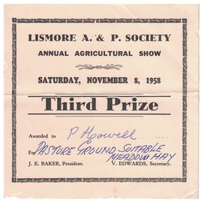
Prize Certificate, Lismore A. & P. Society Annual Agricultural Show, Third Prize, P. Howell, 1958
Awarded at the Lismore A. & P. Society Annual Agricultural Show to Percy (Ronald Percival) Howell of Mannibadar, for Pasture Ground Suitable Meadow Hay. Event was held on Saturday, November 8th, 1958. Percy (Ronald Percival) Howell farmed Corriedale and Merino sheep on his property at Mannibadar. His sons were Ray, Ron and Mervyn (who was killed in action in the last days of World War II).Cream cardboard prize certificate with black printed text. Text: " LISMORE A. & P. SOCIETY / ANNUAL AGRICULTURAL SHOW / SATURDAY, NOVEMBER 8, 1958 / Third Prize. "lismore a. & p. society, percy (ronald percival) howell, prize certificates, prize ribbons, rural activity, lismore a & p show -
 Warrnambool and District Historical Society Inc.
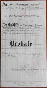
Document - William J Osborne Probate 1900Document, 1900
Tait collection: item 48 of 62 This is a document giving details of the Will and Probate of William James Osborne, a Tallangatta farmer who died in 1896 at the age of 59. His death place is given as Tower Hill. A William Osborne is listed as a Wangoom farmer in 1856, a farmer at ‘Thompson’s Old Farm’ in Allansford in 1866 and a farmer at Winton Farm on the Allansford Road near Shipley in 1869 but these references may be to William Osborne’s father as there is mention of a William Osborne, Junior at that time. William James Osborne left real estate to the value of £560 and personal estate to the value of £81 to his wife, Hannah. The lawyer who drew up this document was Ernest Chambers who had legal offices in Warrnambool, Koroit and Port Fairy at the end of the 19th century and the beginning of the 20th century. He was in possession of this document and it has passed down to successive lawyers occupying the legal premises in Kepler Street where it was located in 2014 (former premises of the law firm of Mackay Taylor). This document is of interest as it gives details of the Will and Probate of William James Osborne, a farmer in the Allansford area in the 19th century. This is a cream-coloured piece of parchment paper folded in two to make four pages. Three of the pages have handwritten material in brown ink and the pages are not ruled. A seal of the Supreme Court of Victoria is attached with a green ribbon and there is one red stamp of the Master in Equity of the Supreme Court. The document is somewhat stained but legible. The document gives details of the Will and Probate of William Osborne of Tallangatta in the County of Heytesbury. He died in 1896. In the Supreme Court of the Colony of Victoria in the Probate Jurisdiction in the Will of William James Osborne late of Tallangatta in the County of Heytesbury in the Colony of Victoria Farmer deceased. ernest chambers, warrnambool lawyer, william james osborne, tallangatta, tait collection -
 Kiewa Valley Historical Society
Wash Board Glass, mid 1900s
This washboard is relatively "young" in that the timber has not "aged," however it could have been used by a rural family to wash "delicate" clothing which could not be placed within a large family washing machine or "copper". This type of washboard i.e. glass washboard, was used extensively during the war periods, 1914 to 1918 and 1939 to 1945 when corrugated metal was in scarce supply. Rural areas were the last sectors in Australia where washboards where, through necessity( droughts and lack of domestic water), used up until the late 1900s. This lingering usage was due to the fact that rural properties, on the whole, had water supplies sourced from farm dams and be the ones whose priority feed was targeting crops and farm animals before clothes and other domestic requirements. In the two millennium however, most rural areas are well stocked with water supplies and the very strict edict of conserving water, especially during droughts, of earlier times is not so critical.The Kiewa Valley although well supplied by rivers, streams and artesian water does occasionally through severe drought lack of water for farm domestic washing requirements.This washboard is made of a wooden frame and glass insert (corrugated on one side and smooth on the other). The washboard glass panel is contained within the wooden frame by routered grooves. The frame extends beyond the glass to form two legs below the glass insert and a hand grip above it. This hand grip allows for one hand to hold the washboard firmly upright and one hand to rub clothes vigorously (up and down) against the glass ridges.This action combined with a soap and water based freeing agent loosen any dirt particles which can be rinsed off. The appearance of this washboard is basic but does not detract from its effectiveness. The lack of "wear and tear" on the wooden frame suggest limited use. The construction suggests good workmanship even though there is no manufacturer's logo to be found on it.hand washing, household washing, domestic clothes washing, laundry -
 Otway Districts Historical Society
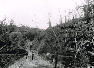
Photograph, Brucker, Powneys Cutting being excavated, c.1902, c.1902
Because of the vast quantity of piles for harbour works Pettit Bros. of Geelong arranged for an addition siding to be installed at Ferguson on the north side of the station in 1913. They then laid a tramway in a northerly direction along the original alignment of Charley's Creek road to the top of Powneys Cutting, 1.8 km from Ferguson, where a log winch was sited. This powerful winch hauled carefully selected piles from the north-west. Jim Facey and Jim, Ted and Tom Cashin formed a partnership to log an area along the Charley's Creek Road six kilometres from Ferguson, operating full-time from 1934. After leasing three Crown sites and cutting them out the partners shifted logging operations to Powneys farm, which they had purchased, and laid a log trail into the farm. The old road reserve was also purchased, and the log tram continued along the road reserve for one kilometre to Powneys Cutting. Logs were winched up to the tramline and despatched to the mill along the falling grade of the road.B/W. 201mm x 268mm. Powneys Cutting being excavated by four men, two men on either side of the slope, and a horse at the end of the line, in c.1902.ferguson; powneys cutting; tramways; powneys farm; pettit; jim facey; jim cashin; ted cashin; tom cashin; charley's creek road; -
 Orbost & District Historical Society
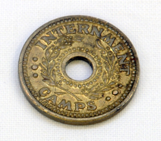
coin, Arendsen & Sons, WW11
For security reasons, tokens were used in Australian WW11 Internment Camps. They were introduced in 19433 to replace the paper canteen coupons. This token was used at the internment camp at Bete Bolong just outside Orbost during WW11. This camp was established in 1943 and was there until 1946. The internees had been transferred from the camp at Murchison East to provide farm labour. The coin was given to Lindsay Thomson when he was a student.This token was used at the Bete Bolong POW camp from 1943-1945. This camp housed Italian POWs, some of whom remained/returned after the war to settle in Orbost.An internment camp coin. This is a one penny coin token with a hole in the centre. It is made of brass.ONE PENNY INTERNMENT CAMPStoken ww11 bete-bolong internment-camp -
 Lara RSL Sub Branch
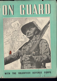
Book, On Guard with the Volunteer Defence Corps
Krithia, Quinn's Post Lone Pine, The Nek, Hill 971, SAri Bair, Chunuk Bair, Hill 60, Fromelles, Ypres, Messines, Menin Road, Broodseinde, Polygon Wood, Paschendalle, Strazeele, Pozieres, Moquet Farm, Bullecourt, Villes Bret, Hamel, Mont St. Quintin, Peronne, Hindenburg Line, Romani, Magdhaba, Rafa, Gaza, Beersheba, Jerusalem, Jericho, Es Salt, Amman, Megiddo, Sharon, Damascus.2 x On Guard with the Volunteer Defence Corpsvolunteer defence force in wwii, europe -
 Greensborough Historical Society
Newspaper Clipping - Digital Image, Cherel Sartori, Funeral notices for Claude Amiet 1998, 20/01/1998
Death notices collected by Cherel Sartori's following the death of Claude Amiet in 1998. Kell's Cottage was built 1917, at 112 Henry Street Greensborough by William Mitchell on the 60 acre dairy farm owned by Ethel and Walter Kell. This collection of photographs was copied by Cherel Sartori (who owned the house from 1990-2000), following a visit by Claude Amiet who lived in the house as a child in the early 20th century.Digital copy of funeral and death noticeskell's cottage, claude amiet, cherel sartori -
 Kiewa Valley Historical Society
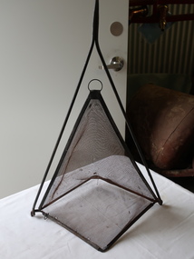
Handmade Tool - Insect Cover or Sieve or Fishing Net or yabby trap
Flies are plentiful and a problem especially in Australia's summer. Farms were a breeding ground for flies that bred in cow manure. Fly-wire was used to keep flies away from food as well as light cloth covers. Farmers could use this sieve to fill with sand etc. to sort the sizes and also to use for eg. wheat to sort the grain. Yabbies are trapped in the creek or river by leaving food in the net for the yabby to crawl into.Food covers were used by residents of the Kiewa Valley especially as many of them were dairy farmers. Farmers often made their own tools for a purpose such as sieving or for the family catching yabbies to eat or for fun.Tall triangular steel fly wire cover with a steel handle and frame. or The frame can be held in order to fill the sieve or to empty it. or the frame can hold bait for yabbiesfood cover, fly-wire, flies, sieve, handmade tool -
 Warrnambool and District Historical Society Inc.
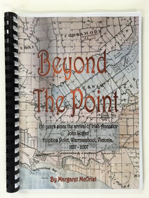
Booklet, Beyond the Point, 2007
This book was written in 2007 by Margaret McOrist to mark the 150th anniversary of the arrival in the Warrnambool area of John Logan. It is a sequel to a 1991 book, ‘Clotted Cream and Mangels’ which told the story of John Logan and his wife Mary Gardner. They lived at Hopkins Point, Warrnambool and the book, ‘Beyond the Point’ tells the story of the Logan descendants. When the farm land was sub-divided and sold the nearby beach was named ‘Logans Beach’. This book is of considerable interest as it tells the story of the descendants of important early settlers, John Logan and Mary Gardner. The area where they first settled is now of major interest as Logans Beach (named for the Logan family) is the well-known whale watching area. Southern Right Whales return to this beach each year and the females calve and remain up to three months at this beach, making it an important ‘whale nursery’. This is a soft cover book with black plastic ring binding and clear plastic sheets covering the front and back paper covers. The front cover has a reproduction of an 1891 map of Warrnambool and district with the title of the book and other information superimposed on the map. The back cover is black. The book has 101 pages and contains information on the Logan families who lived at Tooram in Allansford and their descendants. There are many black and white and colour photographs, diagrams, maps and family trees. Front Cover: ‘Beyond the Point, 150 years since the arrival of Irish ancestor, John Logan, Hopkins Point, Warrnambool, Victoria, 1857-2007, by Margaret McOrist’. john logan and mary gardner, hopkins point, logans beach, tooram, history of warrnambool -
 Bendigo Historical Society Inc.
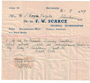
Financial record - Invoice from F.W. Scarce General Storekeeper Raywood, 1949
The McCormick name in farm machinery dates back to Cyrus McCormick, who produced the first successful reaper in 1831. McCormick's company was one of the pieces that eventually became International Harvester. International renamed their new 10-20 and 15-30 tractors as McCormick-Deering in 1923. The McCormick-Deering name was used on standard (wide) front tractors for the next three decades, until it was phased out in favor of the International name.Joan Filbey Collection: Invoice from F.W. Scarce General Storekeeper Phone 14 Raywood.Agent for Goldsbrough Mort General Agencies A/cs. Strictly Monthly. 1 Item McCormick-Deering 10-20 Tractor Steel Wheels sold as reconditioned 325 pound by Bray and Sinclair, Kent Street Ascot Vale. Receipt stamps attached with the writing: Received above payment, F W Scarce 16/8/49history, bendigo, mccormick-deering tractor, raywood, f.w. scarce, joan filbey collection -
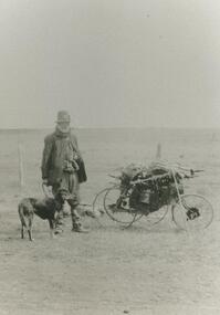 Lake Bolac & District Historical Society
Black and white photograph, Swagman
Swagman, travelling through the Lake Bolac district. These 'swaggies' often had regular, seasonal 'runs' which they would follow, returning to the same hamlets and farms at the same time every year to ask for minor chores in order to earn a meal or to obtain some flour, tea and sugar. After both wars, the numbers of swaggies increased as returned soldiers, who couldn't settle to (or couldn't find) regular employment, took to the roads.lake bolac, swagman -
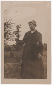 Rutherglen Historical Society
Photograph - Image, c1890
Margaret Ellen Holloway was born in 1864 at Indigo via Rutherglen. She married William Hugh Hooke in 1892. Their children were : Allan b 1893, Ida Mary b 1895, Normal b 1896 KIA 1916 WW1, Maxwell b 1902 and Violet b 1904. The orchard that Margaret is photographed in is the family orchard and farm belonging to relatives being the Mills and Holloway families. The orchard was south of Barnawartha. Photograph of Mrs Hooke (nee Holloway) in an orchard.Written on back: "Mrs Hooke nee Holloway"hooke family, holloway family, margaret holloway, margaret hooke -
 Melton City Libraries
Photograph, Wendy, Bon and Peter Barrie, c.1948
Sections of the property from the Ferris Rd to the Toolern Creek were compulsorily acquired for the construction of the Melton By Pass road to become the Western Freeway. The freeway plan divided the original 1911“Darlingsford” farm. The section of the Ferris Rd 70-acre paddock belonging to Bon became the Freeway and roundabout. The construction to the west passed over the paddocks and the internal track along the fences connecting the Barrie brothers to the original Homestead at the Toolern Creek. Wendy, Bon and Peter Barrie entering Ferris Road from houselocal identities -
 Phillip Island and District Historical Society Inc.
Photograph Album, Kodak, Phillip Island Cemetery, c 1990
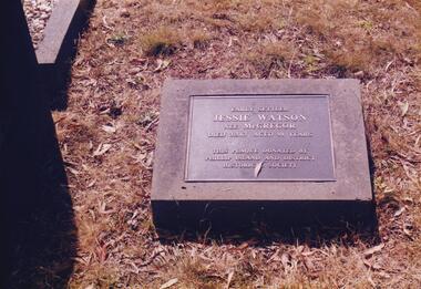
The Album was compiled by Nancy McHaffie late 1990's, with the assistance of Edith Jeffery's, with her book "Garden of Memories" and extensive knowledge of Phillip Island. The Cemetery lies back from the road and is surrounded by Manna Gums, rare Peppermint Gums, Blackwoods and other native trees. In all 25 acres of land were set aside as Crown Land in the land settlement of 1868. There are 6.2 acres of wetlands near the cemetery entrance.466-36: Jessie Watson was a daughter of the McGregor family who came to the Island in the very early days. Their selection was one of the most exposed areas on the Island. Jessie was married for a brief period and continued, with her brother Charlie, to work the family farm. Jessie was a hard worker and died in 1963 aged 98. The Plaque on her grave was donated by the Phillip island & District Historical Society. 466-37: Malcolm Sutherland. Malcolm died age 8 years while on a holiday on Phillip Island. His father was Dr. Alexander Sutherland who conducted his own school "Carlton College" Melbourne. Dr Sutherland was also appointed to the Melbourne Public Library committee for the papers taken to England by Governor La Trobe in May 1894. Malcolm was the only son of Alexander & Lizzie Sutherland.phillip island cemetery, malcolm sutherland, jessie watson nee mcgregor, nancy mchaffie, edith jeffery -
 Phillip Island and District Historical Society Inc.
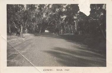
Photographs, 1940's
Seven photographs from a collection of 33 donated by Leonie Brennan. Photographs belonged to Edward (Ted) Sands, hairdresser.Photograph 215-10. Phillip Island Tourist Road (Cowes to Newhaven) in 1940, showing mature eucalypt trees on both sides of the road. Photograph 215-11. Car and tent possibly on a foreshore area on Phillip Island. The car was owned by "Roy". Photograph 215-12. Phillip Island Hotel in Walpole Street, Cowes. Photograph 215-13. Newhaven Boys Home showing farm buildings. Photograph 215-14. Bayview Guest House, The Esplanade, Cowes, with distinctive front fence. Photograph 215-15. The Chapel at Newhaven Boys Home, Phillip Island. Photograph 215-16. The Alvina ferry with passengers on board. Photograph 215-17. Very dark photograph of shops in Cowes. One with sign showing ice-creams and a Grocer Shop next door.Four photographs with "Cowes" month and 1940.main tourist road, phillip island, camp site phillip island, phillip island hotel cowes, hotels, guesthouses cowes phillip island, bayview guesthouse cowes, newhaven boys home phillip island, newhaven boys home chapel, the alvina, ferries, shops at cowes phillip island, mr edward (ted) sands, leonie brennan