Showing 2265 items
matching map collections
-
 Friends of Ballarat Botanical Gardens History Group
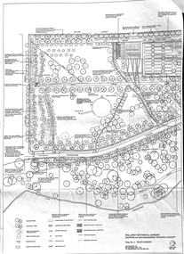
Work on paper - Ballarat Botanical Gardens Master Plan, Final Draft 1995, 1995
This is the "Final Draft" of the Ballarat Botanical Gardens Masterplan in 1995.This document gives some insight into how the Ballarat Botanical Gardens have developed since 1995.There are 6 pages of print and 5 mapsThe City of Ballarat logo is in the centre of p.1.doctor john garner, john garner, john garner collection, friends of ballarat botanical gardens, ballarat botanical gardens, masterplan, gardens, ballarat, drawings -
 Friends of Ballarat Botanical Gardens History Group
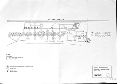
Work on paper - Ballarat Botanical Garden Conservation Analysis and Policy, Volume 1, December 1994 and 2002, December 1994 and April/May 2002
The work entitled Ballarat Botanical Garden Conservation Analysis and Policy was prepared for the City of Ballarat.The pages selected give some perspective on the policy and planning of the Ballarat Botanical Gardens in the recent past.14 pages printed on both sides with black and white pictures and one map. Pages are not numbered consecutively; a selection has been made from the work cited in the name and title."Joan" is printed in blue biro in the top lefthand corner of the title page. [Presumably Joan Garner, President of the FBBG].ballarat botanical garden, conservation analysis and policy, city of ballarat, allom lovell & associates pty ltd., conservation architects, john patrick pty.ltd., landscape architects, friends of ballarat botanical gardens, john garner, doctor john garner, john garner collection, gardens, ballarat -
 Falls Creek Historical Society
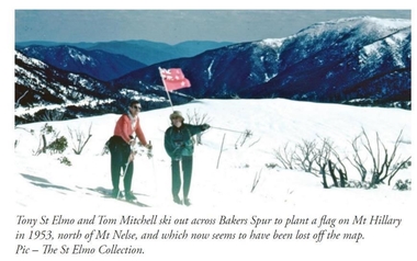
Photograph - Tom Mitchell and Toni St. Elmo plant flag at Mt. Hillary
Tom Mitchell was a strong supporter of trans-Tasman ski competitions and in the early 1950s visits between local clubs became common. In 1953 a team from New Zealand visited Falls Creek for the first time. This was only a few months after Edmund Hillary and Nepalese Sherpa Tenzig Norgay became the first climbers confirmed to have reached the summit of Mount Everest. Toni St. Elmo, supported by Tom Mitchell proposed that a peak on the Bogong High Plains northwest of Mt. Nelse should be named Mt. Hillary in honour of the New Zealander's success. He also suggested a ceremony should be held during the visit of members of the New Zealand Ski team to Australia in September 1953. This image from the St. Elimo Collection held by the Falls Creek Historical Society, represents the planting of a New Zealand flag on the mountain during the ceremony.This image is significant because it is part of the St. Elmo Collection which documents early pioneers of Falls Creek and their outstanding contribution to skiing in Australia.A coloured image of two skiers carrying a New Zealand flag across the High Plains.Beneath the image: Tony St Elmo and Tom Mitchell ski out across Bakers Spur to plant a flag on Mt Hillary in 1953, north of Mt Nelse, and which now seems to have been lost off the map. Pic - The St Elmo Collection.tom mitchell, st. elmo collection, toni st. elmo, sir edmund hillary -
 Bass Coast Shire Council - Art Collection
Photograph - MAP Photos Wonthaggi, Various Photographers
Australia58 Photos -
 Bacchus Marsh & District Historical Society
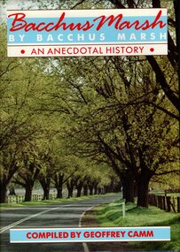
Book, Bacchus Marsh by Bacchus Marsh: an anecdotal history, 1986
Bacchus Marsh by Bacchus Marsh is an anecdotal history of the town and district of Bacchus Marsh. It is a collection of memories of 49 residents recorded in oral history interviews and then adapted into a written record. Most of the interviewees had lived in Bacchus Marsh for many decades and are from a variety of occupations and backgrounds. The oldest interviewee was born in 1890 and the youngest was born in 1938. The interviews were conducted by Geoffrey Camm who then transcribed them and edited them for this publication. A black and white photographic portrait of each interviewee accompanies each chapter. The book includes maps and an index of individual and family names. Publication citation: Camm, Geoffrey, compiler, Bacchus Marsh by Bacchus Marsh: An anecdotal history, Bacchus Marsh, Vic. : Shire of Bacchus Marsh in conjunction with ; Melbourne: Hargreen Publishing, 1986. 392 pages.non-fictionBacchus Marsh by Bacchus Marsh is an anecdotal history of the town and district of Bacchus Marsh. It is a collection of memories of 49 residents recorded in oral history interviews and then adapted into a written record. Most of the interviewees had lived in Bacchus Marsh for many decades and are from a variety of occupations and backgrounds. The oldest interviewee was born in 1890 and the youngest was born in 1938. The interviews were conducted by Geoffrey Camm who then transcribed them and edited them for this publication. A black and white photographic portrait of each interviewee accompanies each chapter. The book includes maps and an index of individual and family names. Publication citation: Camm, Geoffrey, compiler, Bacchus Marsh by Bacchus Marsh: An anecdotal history, Bacchus Marsh, Vic. : Shire of Bacchus Marsh in conjunction with ; Melbourne: Hargreen Publishing, 1986. 392 pages.bacchus marsh, bacchus marsh history, biographies, anecdotes -
 Bacchus Marsh & District Historical Society
Map, Bacchus Marsh Township and Nearby Districts Maps Volume
... in the carriage of their duties. This collection of maps are significant ...This volume of maps is believed to have been compiled by staff at the Shire of Bacchus Marsh and was presumably used to inform and assist Shire staff and Councillors in the carriage of their duties.This collection of maps are significant due to their rarity as many of them are unique maps made for local purposes in the Bacchus Marsh region. They are also of strong research value containing a wide variety of information including landholders, land sales, infrastructure, such as roads, bridges, public, commercial and private buildings, houses, land use, and geographic features over multiple decades from the late nineteen century into the middle part of the twentieth century.One bound volume of maps comprising cadastral maps, (indicating property owners and land boundaries), land plans and real estate auction plans and advertising material, and other maps indicating major infrastructure like proposed roads and irrigation areas. Most of the maps and plans are of Bacchus Marsh and nearby areas but some maps are of nearby towns such as Melton, Ballan and Blackwood. The volume comprises 52 pages. Most pages have a single map or plan pasted onto it but some contain 2 or 3 different maps. There are 81 maps in total. Map 1 Liquidators Sale 1896. Map 2. Woodside Estate Sale 1913. maps, maps bacchus marsh, maps bacchus marsh region -
 The Beechworth Burke Museum Research Collection
Card (Series) - Index Card, George Tibbits, William Street, Beechworth, 1976
George Tibbits, University of Melbourne. Faculty of Architecture, Building and Town & Regional PlanningIndex system that support the research for Beechworth : historical reconstruction / [by] George Tibbits ... [et al]Arranged by street names of BeechworthEach index card includes: street name and number of property, image of property, allotment and section number, property owners and dates of ownership, description of the property according to rate records, property floor plan with dimensions.beechworth, george tibbitsbeechworth, george tibbits -
 The Beechworth Burke Museum Research Collection
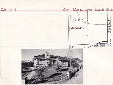
Card (Series) - Index Card, George Tibbits, Cnr Kars & Last Streets, Beechworth, 1976
George Tibbits, University of Melbourne. Faculty of Architecture, Building and Town & Regional PlanningIndex system that support the research for Beechworth : historical reconstruction / [by] George Tibbits ... [et al]Arranged by street names of BeechworthEach index card includes: street name and number of property, image of property, allotment and section number, property owners and dates of ownership, description of the property according to rate records, property floor plan with dimensions.beechworth, george tibbitsbeechworth, george tibbits -
 The 5th/6th Battalion Royal Victoria Regiment Historical Collection
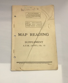
Booklet - Book, Map Reading No. 13 1942, 1942
Military guide to map readingBook made of yellowed paper with black print. It is bound by two staples and has three holes punched into the left side for storage in a ring binder. There is a crease that runs from the bottom left to the top right of the cover.wark vc club, military manuals, ww2, regimental property -
The 5th/6th Battalion Royal Victoria Regiment Historical Collection
Book, Manual of Map Reading, Photo Reading and field Sketching 1929, 1929
Pam with brown card cover. Has a Royal coat of Arms located above the title. Has several fold out maps, many of which protude from the book. On a number of the 160 pags there are diagrams which are printed in limited colour.J.G.Bowe is hand written at the top right hand corner in black ink.regimental property, wark vc club, inter war, manual -
 The 5th/6th Battalion Royal Victoria Regiment Historical Collection
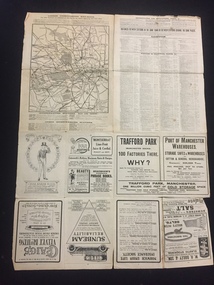
Map, Britain and Underground Railways, July 1919
Used by Australian Soldiers whilst on leave after WW1.Reversible map made of paper. One side has a map of Britain and Ireland printed in colour, the other has a map of the London underground as well as several advertisements. there are small tears along the fold lines.wark vc club, regiment property -
 The 5th/6th Battalion Royal Victoria Regiment Historical Collection
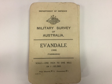
Map, Military Survey of Australia. Evandale (1939) (Tasmania), 1939
Fabric backed colour map, with card cover that folds into a small book. Scale one inch= one mile.military, survey, map, tasmania, ww2, wark vc club -
 The 5th/6th Battalion Royal Victoria Regiment Historical Collection
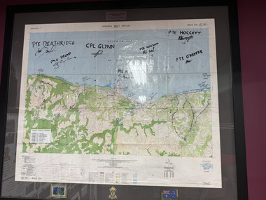
Map - Honiara Map, Honiara West Special used by members of 5/6
Honiara West Special signed by 7 members of 5/6 RVR who were deployed on Operation AnodeThe Map is framed in the glass frame withe the Operation Anode patch, Australian Flag and 5/6 unit symbol displayed below the Map. It has been signed by 7 members of 5/6, each member's PMKey is also displayed on the Map -
 Mont De Lancey
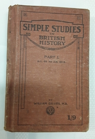
Book, William Gillies, M.A, Simple Studies in British History Part 1, 1920
A simple study in British History for secondary school students with a fold out map of the British Empire at the time - published in 1920. There is a list of the dynasties and kings and queens and a table of Periods in British History which can be referred to.A small tan cloth covered hardcover book with the title: Simple Studies in British History Part 1 B.C. 55 to A.D. 1603 printed in black lettering on the front cover with the publisher, a round publisher symbol and 1/9 at the bottom. The title is printed on the spine. This is a Second Course of Reading in British History by William Gillies, M.A. Inside, opposite the title page, is a foldout map of the British Empire throughout the world, showing the empire in red. Black and white illustrations and photographs are included. At the back is included three other history titles. It is quite damaged and worn through use. Pp.168.non-fictionA simple study in British History for secondary school students with a fold out map of the British Empire at the time - published in 1920. There is a list of the dynasties and kings and queens and a table of Periods in British History which can be referred to.great britain - history, history, textbooks -
 Melton City Libraries
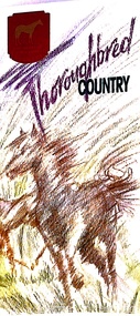
Pamphlet, Thoroughbred Country, c.1985
"Melton has a long and celebrated history of horse breeding and racing. Draught horses were a crucial aspect of life in the early days of European settlement, and were heavily depended upon for both transport and agricultural labour. Peppercorn trees at the corner of Station and Brooklyn roads have been associated with a horse trough installed there to provide a drink to workhorses carting produce to the chaff mills and railway station south of Melton.20 Breeders, trainers and harness drivers in the area later became such an influential force in the equine industry that this came to be a defining aspect of the district’s identity and reputation.Pioneer of the Victorian horse racing industry and early Rockbank squatter William Cross Yuille was one of the earliest importers of stud racehorses in the district in the 1850s. A leading sports editor and writer, Yuille established bloodstock auctioning agency W. C. Yuille & Co. and was involved in the compilation of the first Australian Stud Book, which ensures the integrity of thoroughbred breeding in Australia. According to early Melton chronicler Alexander Cameron, horse races were first organised in the area by Rockbank farmer William Keating. Keating owned racehorses of his own, and many brought horses from Melbourne for the events, which ‘drew large gatherings’.22 Melton Racing Club meetings were held on the Exford Estate with the permission of H. W. Staughton, who built a small wooden grandstand in 1882. Other early races and sports meetings are said to have been held in the vicinity of the current-day Melton golf course.23 An 1884 article reported that Melton’s ‘race programme … equals any put forth by country towns of far greater size’. Ernest Clarke was another important figure in the early horse racing industry in Melton. He established the Melton Stud in 1902, which bred numerous successful racehorses. Perhaps most notably The Welkin, one of the most famous stallions in Australian horse racing in the early twentieth century. The Welkin sired Gloaming, bred by Clarke at the Melton stud in 1915 and one of Australia’s greatest champion racehorses. During a long and prestigious career in both Australia and New Zealand, Gloaming achieved a triumphant 57 wins out of 67 starts and won a record amount of prize money. Ken Cox purchased the Stockwell Stud in Diggers Rest in 1957 and developed it into one of the largest and most renowned thoroughbred breeders in Australia. With its top-class facilities, international design standards and scientific methods, Stockwell became ‘the flagship of the Victorian breeding industry’.26 As well as racing studs, numerous trotting tracks were established on the flat plains around Melton in the 1960s.27 Other studs to play a leading role in the development of Melton as thoroughbred country were Cornwall Park and Merrywood at Toolern Vale, St John’s Lane Stud at Diggers Rest and Birchwood, Teppo Park and Dreelburn in the far north-east of the shire, near Sunbury. By 1985, thoroughbred horse breeding was such big business in Melton that the shire council adopted the slogan ‘The Heart of Thoroughbred Country’, which was used throughout its promotional material.29 But the slogan contained deeper meaning and was not just about Melton’s great equine industry and thoroughbred champions, the council explained: ‘“Thoroughbred Country” should be seen as a new concept of Melton, as a place where people can achieve the “Thoroughbred” ideal, excellence in all aspects of life’. The aim of the council in promoting ‘The Heart of Thoroughbred Country’, was ‘to instil in present and future residents the feeling that this is a place that is better than others. A place to be proud of’. In 1988, Melton’s champion reinsman Gavin Lang won his 176th race of the season, claiming the national harness racing record for the most wins in a single season.The following year, the first Melton Plate was held at Moonee Valley Racecourse, cementing the district’s importance in the harness racing industry. The inaugural winner was Victorys Phil, owned by local Danny Mullan. By the 1990s, Melton had earned the title of the ‘Home of Harness Racing in Victoria’. State-of-the-art, world-class harness racing facility and entertainment complex Tabcorp Park opened in Melton in 2009. In 2011, the Shire of Melton was home to over 140 registered trainers and over 1,200 horses. The municipality’s continuing leadership and influence in the industry today is a testament to the skills, talents and leadership of the local community over its history".Shire of Melton pamphlet of a map and information of the equine industry in Meltoncouncil -
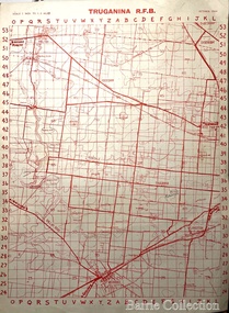 Melton City Libraries
Map, Truganina R.F.B, 1964
... to the Truganina Fire Brigade Truganina R.F.B Map Barrie Collection ...The Mount Cotterill Group encompassed the Rural Fire Brigades of Melton, Rockbank, Sydenham, Toolern Vale, Truganina, and Werribee and later Diggers RestMap belonging to the Truganina Fire Brigade emergency services -
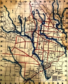 Melton City Libraries
Map, Mount Cottrell Fire group, Unknown
... Fire group Mount Cottrell Fire group Map Barrie Collection ..."In 1966, the Mount Cottrell Fire Brigades Group was formed as a way of consolidating the smaller groups around Melton, Rockbank, Toolern Vale, Sydenham, Truganina and Werribee. Its headquarters were established at the home of Ernest ‘Bon’ and Edna Barrie in Ferris Road, Melton. Captain Bon Barrie was a member of the Melton Fire Brigade and elected group and communications officer of the new Mount Cottrell Brigades Group". Fire Brigade Meeting 14th September held at Rockbank Formation a new Group in Region 14 Present: R/O H Rothsay, Assistant R/O R Orchard Tru? G Summerton Purpose of Group The pooling of the equipment in the area should be co-ordinated under one leader. The Brigade and private equipment should be co-ordinated under one leader. Formation was carried unanimously. To be called Mt Cotterill Group. Rockbank nominated Captain E W Barrie elected, Secretary K Watt Toolern Vale. Names listed C/O K L McNaughton Anakie Group COO/O R B Chirnside Lieut J Richmond Capt E Gillespie Toolern Vale Eddie L/ T S Atkin Stan L/T B Storey Bert Sec K Watt Keith Capt E W Barrie Melton Bon L/T K Gillespie Keith A Gillespie Arthur L/T G Lunson George L/T J Robinson Jeff Capt A Marquand Truganina Alan L/T I Cowie Ian Sec T Gard Tom Capt G Harrison Rockbank a/ps G Harrison N Harrison N Fisher a/ps S Hirt Melton Steve Pres M Chomley Sydenham Capt S Hughes Stan Capt L Waterson Werribee Lex Res/o J Hanson G/O S Cooper Bacchus Marsh Syd P/GO W Lidgett Wal Pro/O D Dunton G/O T Healy R C [Mt Macedon] Tom Reg Sec G Douglas Hand written notes of Edna Barrie Typed by Wendy Barrie Maps of the Mt Cottrell Fire groupemergency services, maps -
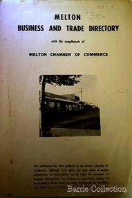 Melton City Libraries
Booklet, Melton Business and Trade Directory, c.1965
BUSINESS TRADE AND DIRECTORY MAP NORTH of High Street RALIEGHS Road - Early settlers Oliver Reierson ( Norwegian) Raliegh SHEBLER Court Auguste EMIL Court Jongebloed Family residence “Hemlich” ALEXANDRA Street Coronation King, Queen Alexandra - 1903 O’NEILS Road Farmer OLDERSHAW Road CORR Grove Early landowner, Teacher at the Common School – Denominational Churches, 1850’s Wesleyan (Methodist) BRYAN Court 1850’s resident renamed from earliest town site - Flat HURLEY Street Early settler and farmers - CHESNEY Road was named Minns, due to duplication altered to Chesney (Minns) SOUTH of High ALKEMADE Drive. Family name ARNOLD Court Family BARRIES Road Charles Ernest Barrie “Darlingsford” 1911 Residence KILPATRICKS Road became Barries Road west of Station Road BLACKWOOD Drive Alexander, Early settler CALLANAN Drive Surveyor early LUBY Court John Luby - Crown Grant Land title KERWIN Street Michael - Crown Grant land title (deleted due to Freeway)Pamphlet of Melton Businesses and map of the townlocal identities, misc., council -
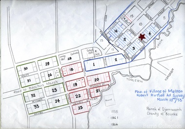 Melton City Libraries
Map, Plan for the Village of Melton, 1853
... Melton Town 1853 Plan Plan for the Village of Melton Map Barrie ...Site of early village Section numbers 1 - 17 Later became the Flat known as the Common Robert Russell – Surveyor Pinkerton, Sherwin, Bryan, Pyke, Yuille, CollyerMelton Town 1853 Plancouncil -
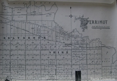 Melton City Libraries
Map, Parish of Derrimut, 1931
... Council Map of the Parish of Derrimut Parish of Derrimut Map ...Map of the Parish of Derrimutcouncil -
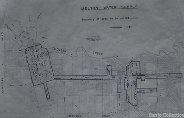 Melton City Libraries
Map, Melton Water Supply, Unknown
... Melton Water Supply Map Barrie Collection ...The development that had arguably the greatest impact in encouraging population growth in the shire during this period, was the establishment of a reliable water supply for the district. This had been a major concern of the local community for over 100 years, since the Melton township was first founded. Despite various schemes over the years to create a reliable water supply, the district was still dependent on bores, wells and tanks when the Melton Waterworks Trust was established in 1961 to address Melton’s water woes. With the opening of the Djerriwarrh Dam in December 1963, the shire’s residents finally had access to a reticulated water supply.Map shows the boundary of the area where the water will be serviced in the towncouncil -
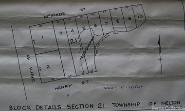 Melton City Libraries
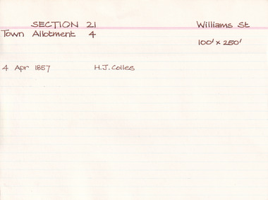
Map, Block details section 21 Township of Melton, 1965
... details section 21 Township of Melton Map Barrie Collection ...In 1861, Mary Dowling and John Luby obtained Crown Grant land on the corner of Smith and McKenzie Street Melton.Section 21 is covers the block of Smith, Henry and McKenzie Street Meltoncouncil -
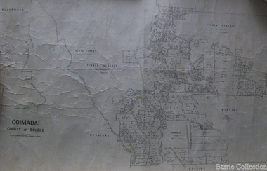 Melton City Libraries
Map, Coimadai County of Bourke, 1911
... Council Town Plan of Melton Coimadai County of Bourke Map Barrie ...Town Plan of Meltoncouncil -
 Tarnagulla History Archive
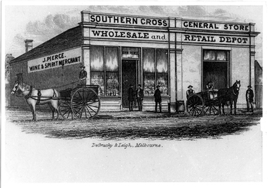
Photographic copy of lithograph: Pierce's Southern Cross Store, Tarnagulla, Pierce's Southern Cross Store, Tarnagulla, circa 1850 to 1871
Murray Comrie Collection. John Pierce's Southern Cross General Store, a wholesale grocer and spirit merchant was put up for sale after Pierce's death in 1871. It was later incorporated into the Flour Mill complex. De Gruchy & Leigh was a publishing and printing firm operating in Melbourne and regional Victoria from the late 1850s until the mid 1860s. The company published almanacs and guidebooks as well as prints (portraits, views and genre scenes), maps and architectural plans (Source: National Portrait Gallery, Canberra). This is a copy created from another item in the collection - a printed piece of paper which was either a packing label or receipt form used at the company or a brand label for bottles, perhaps for wine made by the proprietor. Copy probably made by Murray Comrie in the 1970s. Monochrome photographic copy of a lithograph. Depicts a building with glass front windows and signage stating 'J. Pierce Wine & Spirit Merchant' and 'Southern Cross General Store, Wholesale and Retail Depot'. In front of building on road are two horses hitched to carts and men standing on cart and in front of store. This store was located on the south-eastern corner of Commercial Road and King Street. The building was later incorporated into the flour mill complex.tarnagulla, commerce, shops, stores, shopping, food, alcohol, horses, transport, buildings, commercial road, main street, john pierce, southern cross general store -
 Tarnagulla History Archive
Pages from a book: Poseidon Alluvial Gold Mine, Tarnagulla, Poseidon Alluvial Gold Mine, Tarnagulla, circa 1916
Murray Comrie Collection. Pages from a book (unknown), this excerpt titled 'Poseidon Alluvial Gold Mine, Tarnagulla' by O.A.L. Whitelaw, Field Geologist. Includes a map (also extracted from the book) with title 'Poseidon Alluvial Gold Mines'. Map of the mines entire workings, above and below ground. tarnagulla, poseidon, mine, mining, gold -
Tarnagulla History Archive
Brochure: Golden Triangle Bicycle Rides, Golden Triangle Bicycle Rides, circa 1990s
Donald Clark Collection. A brochure for Golden Triangle Bicycle Rides published by the Shire of Bet Bet. Includes information and a map. tarnagulla, dunolly, shire of bet bet, tourism, maps, cycling, travel, touring, paths -
Tarnagulla History Archive
Prospectus: Reef Mining NL - Tarnagulla Gold Project, Reef Mining NL - Tarnagulla Gold Project, circa 1995
Donald Clark Collection. A cardboard folder with colour image of poppethead on cover and title 'Prospectus: Reef Mining NL - Tarnagulla Gold Project'. Contained inside are maps and mining reports and other information about the Tarnagulla Gold Project.tarnagulla, gold, mining, reef mining nl -
 Melton City Libraries
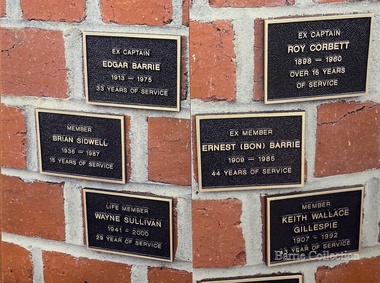
Photograph, Melton Fire Brigade Memorial Wall, 2013
Ernest W (Bon) Barrie, 1909 – 1985 Melton Fire Brigade (and predecessor Bush Fire Brigade) Apparatus Officer, 1945 - 1953 Captain, 1951 - 1965 Mt Cotterill Fire Brigades’ Group Elected Group Officer, on the formation of the Group, 1967. As Group Communications Officer he operated the VL3 LY base radio station from home on a 24 hour basis for fire brigades of Melton, Rockbank, Sydenham, Diggers Rest, Toolern Vale, Truganina and Werribee. With his brother Edgar, he built the first Melton Fire Truck. It was housed on the family property until a fire station was constructed in the Melton township. Recipient of the Queens Medal, 1979 Recognised for 44 years of service on the Melton Fire Brigade Memorial Wall Plaque, dedicated May 2013 Mt Cotterell Fire Brigades G H Q and aerial was erected at No 17 - 19 First Avenue in 1974 at the home of Edna and Bon Barrie. Previously the Mt Cotterell Group VL3LY communication headquarters occupied their h ome in Ferris road at its inception in 1967. The First Avenue headquarters and map room, with radio equipment was also housed at the residence. It was operated with an additional cable connection to Fireman Wayne Sullivan (Deputy C/O) who resided at the rear in Kurrajong Cr.Section of the Melton Fire Brigade Memorial wall with brigade members who have passed away while as members. emergency services, local identities -
 Melton City Libraries
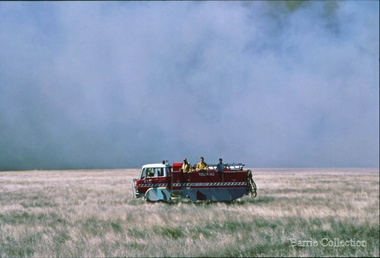
Photograph, Burning Off, Unknown
Many of the brigade and group base radios were situated in private residences and operated primarily by fire fighters wives who held the position of Communications Officer, either registered as a brigade member or informally. Edna Barrie was never registered as an operational brigade member but operated informally as an assistant to her husband Bon. She was however a member of the Melton Fire Brigade Ladies Auxiliary from its inception in 1968, a non-operational position. Edna kept up to date with radio procedure following the 1967 handbook; preparing maps, plotting compass points and taking notes on weather forecasts from the SA Border and Western District. Daily notes were taken in anticipation of fire warnings. These log books and daily radio traffic were incidental to the regular radio schedules. Emergency turnouts noted, burning off times and predicted location of smoke. In the summer fire season all TBF (total fire ban days were recorded.)CFA burning off dry grassemergency services -
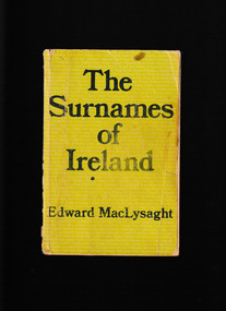 The Celtic Club
Book, Edward MacLysaght, The Surnames of Ireland, 1978
A collection of more than 4000 Irish family names and their county association.Bib, map, p.304.non-fictionA collection of more than 4000 Irish family names and their county association.geneology - irish, local history - ireland